A Fundamental Study of Overall Conservation of
Terrestrial and Freshwater Ecosystems in a
Montane Region of Western Sumatra :
Vegetation, Land-use, and Water Quality
著者
NAKANO Kazutaka, WATANABE Toshiharu, USMAN
Rustam, Syahbuddin
journal or
publication title
南海研紀要
volume
8
number
2
page range
87-124
URL
http://hdl.handle.net/10232/15694
A Fundamental Study of Overall Conservation of
Terrestrial and Freshwater Ecosystems
in a Montane Region of Western Sumatra:
Vegetation, Land-use, and Water Quality*
Kazutaka NAKANO**, Toshiharu WATANABE***, Rustam USMAN****,
and Syahbuddin****
Abstract
For a fundamental study of nature conservation in a region with the headwaters of big rivers in the humid tropics, surveys of vegetation, land-use, and water quality were made around the relatively small lakes of Diatas, Dibaruh, and Talang, in the volcanic highlands of the Province of West Sumatra. Owing partly to the relatively high population density, the area of the natural forests, most of which are legally protected, has decreased to less than one-third of the total area of the terrestrial parts of the catchment basins. Much more than half of the terrestrial area of the basins of both Lake Diatas and Lake Dibaruh is classified as actually cultivated or abandoned upland fields plus residential districts. Most abandoned fields, whose area is far more than that of actually cultivated ones, are covered dominantly by bracken (Pteridium aquilinum). The application of chemical fertilizers has become a normal process during the cultivation in both the upland and wet paddy fields.
The evaluation of the water quality in the lakes using a biological index based on diatom assemblage as well as the results of the measurements of transparency and the standing crops of phytoplankton led to a conclusion that
* A contribution to the Project of Sumatra Nature Study partially supported by Japan Society for the Promotion of Science.
The Kagoshima University Rasearch Center for the South Pacific, 21-24, Korimoto l-chome,
Kagoshima 890, Japan.
Department of Biology, Faculty of Science, Nara Women's University, Kita-uoya-nishi-machi,
Nara 630, Japan.
* * * * Department of Biology, Faculty of Mathematices & Natural Sciences, Andalas University, Air
88 Nakano et al.: Study of Conservation in a Montane Region in Sumatra
neither Lake Diatas nor Lake Dibaruh were eutrophicated as a whole. Some symptoms of eutrophication, however, were also, at least, partially confirmed by means of the values of the index. The results of the analyses of chemical factors and plankton flora there correspond with those symptoms and can be explicated without contradiction when we take other physical factors of the water of the lakes and their inflows into consideration. In addition, the water quality of Lake Dibaruh, which is mostly encircled by very steep slopes, is worse than that of Lake Diatas despite more favorable conditions of the former in regard to the factors of the load of pollutants and lake depth. The above-mentioned phenomena suggest that the eutrophication in both Lake Diatas and Lake Dibaruh is closely connected with the severity of the erosion of surface soil and runoff which contain
the nutrients derived from chemical fertilizers. Therefore, the restoration of natural
forests in the abandoned fields is necessary to abate the soil erosion and the runoff around the two lakes. The results of a quantitative investigation have demonstrated the strong possibility of the natural reversion of the vegetation in those abandoned fields to the forest stage if no fires occur there.
Key words : Conservation, Vegetation, Land-use, Water quality, Sumatra.
Introduction
It is commonly accepted among ecologists that tropical forests, especially rain
forests, play an extremely significant role in maintaining a globally ecological stability and abundant gene resources. In this sense, conservation or proper management of such ecosystems is greatly beneficial to humankind. We here place stress on the distinction between nature conservation and preservation. The concept of nature conservation does not necessarily prohibit human activities, including economic ones, in an area. It should promote harmony between natural processes and human activities although the attitude giving priority to the former will, in the long term, bring the people in the area satisfactory returns. Therefore an area for nature conservation may contain some untouchable nature reserves.
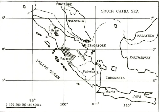
The island of Sumatra is located in such a region as tropical rain forests should flourish and extends both north and south of the equator (Fig. 1). The total area of Sumatra and the adjacent islets is more than 470,000 km2 (Anonymous,
1983).
Sumatra had been relatively developed and commercially exploited among the large islands in the domain of the Dutch East Indies (BLINK, 1926). In recent years, this trend appears to be accelerated. Quite often, economic development and exploitation results in the deterioration of natural conditions. So that we appreciated the worth of beginning a fundamental study for conservation and proper
Fig. 1. Map of Sumatra and its adjacent regions. The chain lines represent the boundary lines of countries ; and dotted lines, boundary lines of the provinces in Sumatra. The area with the slashes shows the territory of the Province of West Sumatra, whose capital city is Padang.
management in a montane region of the Province of West Sumatra which had been one of the political centers in this large island since the fourteenth century until the Dutch invasion in the nineteenth century (LOEB, 1972). Under such political circumstances, the people of this province had already developed an intensive mode of agricultural production on the basis of wet paddy fields and had become an economically and commercially advanced region of this large island in the old times (SCHOLZ, 1977).
Nature conservation of a montane region is closely connected with the fact that it contains many heads of streams. Maintaining those heads is a prerequisite for the conservation of water systems.
Taking the above-stated respects into account, we selected a survey area for
our intensive study. Furthermore, inasmuch as the construction of a resort district
is being embodied in our study site (Anonymous, 1982), our study has also a significance as an environmental pre-assessment before the development of the resort. We have never seen such a comprehensive study of nature conservation as this one insofar as Sumatra is concerned.
90 Nakano et al.: Study of Conservation in a Montane Region in Sumatra
Geographical Background
The area of our study is the catchment basins of three relatively small lakes neighboring on one another, Lake Diatas, Lake Dibaruh (or Dibawah), and Lake Talang including the ponds close to the last of the three. The location of the study area is shown by Figs. 1 and 2. The latitude of the northernmost part of the area is 1°S and the longitude of 101°E is approximately 30 km east of it. Those lakes which are about 45 km to the ESE of Padang, the capital city of the Province of West Sumatra, are in the Barisan Mountains, which devides the water systems of the large island of Sumatra into those flowing toward the Strait of Malacca and those flowing toward the Indian Ocean (Fig. 1).
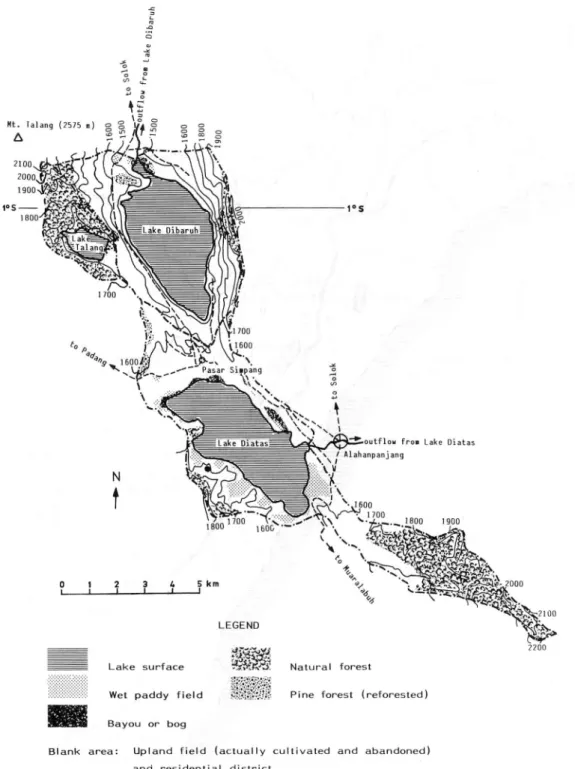
Both Lake Diatas and Lake Dibaruh originated from the valleys which were formed by the graben (VERSTAPPEN, 1973) along the mountains, while Lake Talang and another adjacent pond are considered to be the former craters of the active volcano (VAN PADANG, 1953), Mt. Talang, whose summit (elevation, 2,575 m) is out of our study area (Fig. 3). All the topographical data of this study are based on the maps with the scales of 1/40,000 (Anonymous, 1943), 1/50,000 (Anonymous, 1984a and 1985), 1/100,000 (Anonymous, 1961 and 1962), and 1/1,000,000 (Anonymous, 1974a).
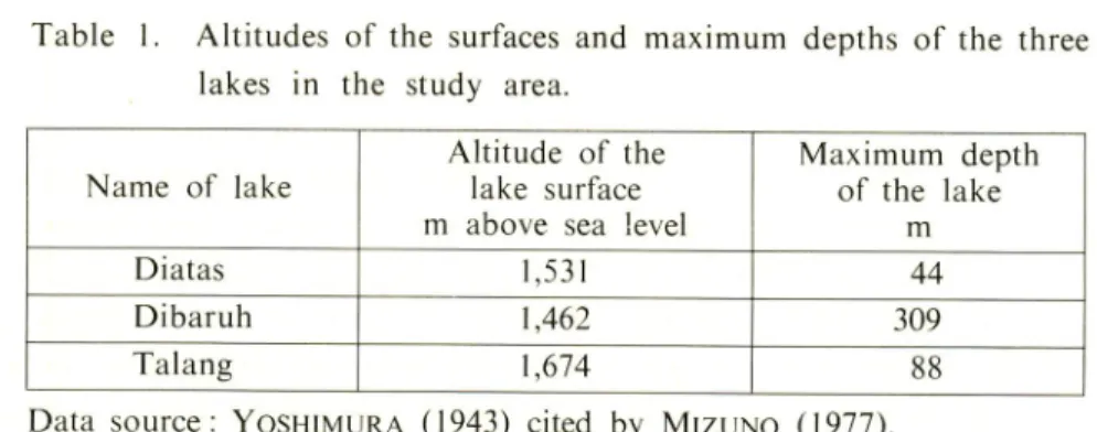
The altitudes of the surfaces and maximum depths of the three lakes are shown in Table 1. The maximum depths of the lakes appear to reflect the topography of the catchment basins of the respective lakes (Fig. 3). Lake Diatas is encircled mainly by gentle slopes, whereas Lake Dibaruh is surrounded by very steep ones (Fig. 8-3) except for the northernmost part (Fig. 8-4) from which a stream flows out of this lake. Lake Talang is encircled mostly by moderately steep slopes (Fig. 8-5).
The areas of the lakes, catchment basins, and terrestrial surfaces in the respective catchment basins are summarized in Table 2. The first two of the three were directly evaluated from the appropriate topographic maps and planimetry using a Planimex 25 manufactured by the Japan Regulator Co. Ltd., Japan. The surface area of the terrestrial part of each catchment basin was roughly estimated on the basis of the three-dimensional topographical model and the planimeter.
Water from Lake Diatas is the source of the Hari River and that from Lake Dibaruh is the source of the Kwantan River, both of which flow into the Strait
of Malacca (Fig. 2). The catchments of the two lakes are very important because they contain the headwaters of two representative rivers in Sumatra. Lake Talang
has no outlet.
The soil covering our study area comes mainly from volcanic ash (Anonymous, 1974b) from eruptions of Mt. Talang. However, the small plain on the southeastern coast of Lake Diatas (Fig. 3) is covered by alluvial soil (Anonymous, 1974b).
NORTH SUMATRA
INDIAN OCEAN
BENGKOLU *-' *\
Fig. 2. Map of the Province of West Sumatra proper. The broken lines represent the lines of the provincial boundaries ; and the thick line in the Province of West Sumatra is the divide which separates the water systems in Sumatra into those that flow to the Indian Ocean and those that flow to the Strait of Malacca. The capital letters of alphabet stand for the lakes in this province : A, Lake Maninjau ; B, Lake Singkarak ; C, Lake Dibaruh (or Dibawah) ; and D, Lake Diatas. The small letters express the volcanoes in this province: a, Mt. Malintang; b, Mt. Ophir (or Talamau); c, Mt. Singgalang ; d, Mt. Merapi ; e, Mt. Sago (or Malintang) ; f, Mt. Talang; and g, Mt. Kerinci.
92 Nakano et al. : Study of Conservation in a Montane Region in Sumatra
Lake surface
Wet paddy field
Bayou or bog
sagas
SfiSSyS! Natural forest
Pine forest (reforested)
Blank area: Upland field (actually cultivated and abandoned)
and residential d i s t r i c t
Fig. 3. Simplified topography and landscape map of the study area. The contour lines are every 100 m.
The chain lines denote the watersheds of the catchment basins of the three lakes, Lake Diatas,
Lake Dibaruh, and Lake Talang. The broken lines show the main motoring roads. The open circles represent the market towns in and near the study area and their sizes imply the comparable degrees of the commercial activities there. The closed circle presents the location of the sampling site for the quantitative study of the vegetational succession in abandoned fields.
Table 1. Altitudes of the surfaces and maximum depths of the three lakes in the study area.
Name of lake
Altitude of the
lake surface
m above sea level
Maximum depth of the lake m Diatas 1,531 44 Dibaruh 1,462 309 Talang 1,674 88
Data source: Yoshimura (1943) cited by Mizuno (1977).
Table 2. Areas of the lake surfaces, the whole catchment basins, and the terrestrial surfaces in the catchment basins of the three lakes.
Name of lake
Area of lake surface
km2
Area of the whole catchment basin including that of
lake surface*
km2
Area of the ter
restrial surface in the catchment basin** km2 Diatas 12.3 41.8 32.6 Dibaruh 11.2 29.3 21.1 Talang 1.2 6.1 5.4 Total 24.7 77.2 59.1
Projection area in topographic maps.
On the basis of a three-dimensional model of topography.
The meteorological data were obtained from records measured at the station on the eastern coast of Lake Diatas. Only the daily maximum and minimum temperatures were measured. So that the data on the mean daily temperature are unreliable. Because it is located close to the equator, there is no seasonal variation of temperature. According to firsthand records from 1983 to 1985, the daily maximum and minimum temperature ranges were between 22° and 26 °C and between 10° and 16 °C, respectively.
The mean annual precipitation for the six years from 1978 to 1983 is slightly less than 2,500 mm and the relatively dry season means June, July, and August (Pusat Studi Lingkungan Hidup Universitas Andalas, 1984). Even in July, the driest month, the monthly rainfall, 82 mm, surpasses the monthly evaporation, 62 mm (Pusat Studi Lingkungan Hidup Universitas Andalas, 1984).
94 Nakano et al.: Study of Conservation in a Montane Region in Sumatra
Population
Two methods for the estimation of the population in each catchment basin were adopted. The first is based on the 1980 census and other official data related to the population change. However, some problems exist because those official data merely informs us of the populations of respective administrative villages around the lakes, and the territories of some of those villages extend
beyond those catchment basins: In addition, the values of official data are always
less beyond permissible errors than those told by the village chiefs. The second method used the total village population (P) and the total house number (H) as reported by the chief of a village, and the number of houses (h) in the part included in a catchment basin of a lake to estimate the population in the catchment (p) as in the following equation :
P=-H--n-We actually counted h in this equation one by one. Although this second method is, of course, not accurate because neither P nor H is necessarily accurate, it is much better than the first, since the population in the catchment basins can be precisely estimated. Nevertheless, concerning the populations of a few villages whose territories are entirely in the catchment basins, we could not but depend on only the official data.
The result of the estimation of the populations in 1985 was as follows: 6600, 5100, and 20 individuals in the catchment basins of the Lake Diatas, Lake Dibaruh and Lake Talang, respectively.
Using the data in Table 2, we calculated the average population density of the terrestrial part of the catchment basin of every lake as follows: roughly 205 individuals/km2 for that of Lake Diatas, 240 for Lake Dibaruh, and 4 for Lake Talang.
According to the 1980 census, the average population density for the whole
island of Sumatra plus the adjacent islets was 59 individuals/km2 and 68 for
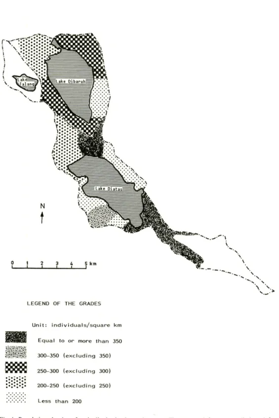
the Province of West Sumatra (Anonymous, 1983). So that the above-calculated values of the population density in the catchment basins of Lake Diatas and Lake Dibaruh are far more than both of the values of Sumatra and the province. The population density of every inhabited district excluding the protected forests (Fig. 3) in the northwest and southeast of our study area is exhibited in Fig. 4. This figure suggests that the standard deviation of the population density around Lake Diatas is larger than that around Lake Dibaruh.
Attention should be paid to the fact that many of the districts with very steep slopes around Lake Dibaruh are rather densely populated (Figs. 3 and 4).
VV.'v^."-::
0 1 2 3 4 5k
1 I I I
LEGEND OF THE GRADES
Unit: individuals/square km
WSmmX Equal to or more than 350
•''."• 300-350 (excluding 350)
250-300 (excluding 300)
•:•:•:• 200-250 (excluding 250)
•'.'.'.•'.•'. Less than 200
Fig. 4. Population density of each district in the study area. The protected forests are eliminated from
the districts for the calculation. The chain lines denote the boundaries of the catchment basins
96 Nakano et at ; Study of Conservation in a Montane Region in Sumatra
Moreover, those slopes are intensively farmed with the application of fertilizers, as will be described later. The district close to the northern coast of Lake Diatas is most densely populated, approximately 450 individuals/km2. This is partly due to the commercial activities at the town, Pasar Simpang shown in Fig. 3.
Vegetation and Land-use
1. General description
Fig. 3 is a simplified map of the topography and landscape of our study area. The elements of landscape are here classified into the following : lake surface, natural forest, reforested pine (Pinus merkusii) forest, bayou or bog, wet paddy field, cultivated or abandoned upland field plus residential district, and the market
town.
The natural forests in the northwestern and southeastern parts of this area are legally protected (Anonymous, 1978). According to Hotta et al. (1984), the genera of the arboreal species often found in the forest around Lake Talang are
Lithocarpus, Castanopsis, Litsea, Ficus, Ardisia, and Syzygium, most of which
floristically characterize the montane forests in Southeast Asia (OHSAWA et al.,
1985).
Besides these protected foresets with relatively large areas, remnant forests are
found on the ridges east of Lake Dibaruh and southwest of Lake Diatas. The
total areas of those natural forests were calculated to be slightly less than 16 km2 (projection area) and 18 km2, respectively, directly from the original maps for Fig. 3 and from the earlier mentioned three-dimensional topographical model. This indicates slightly more than 20 % and approximately 30 %, respectively, of the total projection area of the whole catchment basins and the total surface area of the terrestrial part in those catchment basins (Table 2).
In the bayou around the outlet of Lake Dibaruh, two species of grass, which are utilized for matting and baskets, are grown. The one whose local name is began could be indentified as Eleocharis dulcis. However, the other which is very tall and locally called salua could not be identified because we could not collect the flowers. Nevertheless, we consider it of the genus Scirpus. Anyhow, both the bayous around the outlets of Lake Dibaruh and Lake Diatas and the bogs on the coast of the latter are predominantly covered by the plants belonging to the family, Cyperaceae. A number of plants collected in the bog on the northern
coast of Lake Diatas could be identified as Eriocaulon truncatum, Lipocarpha
chinensis, Cyperus pumilus, Fimbristylis sp., Scirpus mucronatus, Rhynchospora sp., Spathoglottis plicata, Emilia sonchifolia, Sida sp., Dicranopleris (Gleichenia) linearis,
Paspalum sp., Eleusine sp., Xyris indica, Borreria ocymoides, Sacciolepis sp., and
Because of the topographic feature around Lake Dibaruh, its catchment basin has very few wet paddy fields, their total area is estimated at less than 10 ha. On the other hand, the catchment basin of Lake Diatas has roughly 200 ha of wet paddy fields according to the original map for Fig. 3 and our field surveys. The almost flat lands along the northern coast of Lake Diatas appears to be suitable for the cultivation of wet paddy. They, however, lack water for paddies, since they can only depend on direct rainfall for their water supply. So that the rice production in such fields fluctuates in accordance with the socio-economic conditions. Recently, partly because rice production in the whole province increased faster than the rate of its total population (Anonymous, 1981 and 1984b), most of such unfavorable paddy fields in the lands along the northern coast of Lake Diatas were changed into dry fields or abandoned.
At any rate, rice production even in the catchment basin of Lake Diatas
does not suffice for self-sufficiency owing to the small ratio of paddy fields to the population in the catchment, namely, 0.03 ha/individual. In addition, rice yields are low owing to the unfavorability of the climatic conditions for rice production ; no hot season with the daily maximum temperature constantly above
25 °C and no distinctly dry season.
In this highland region, multiple^cropping
in the paddy fields cannot be found. rice
A good overview of agricultural geography of this highland was reported by SCHOLZ (1977). As he stated, the agriculture in our study area is characterized by crops fit for a relatively cool climate, such as Irish potato, cabbage, onion including tuber shallot (in Indonesian, bawang merah), and the sweet calabash
(Passiflora maliformis).
These crops are commercially favorable in the tropics
because they are comparatively scarce in the lowlands of the tropics. Until the 1960s, the northern part of the lands around Lake Dibaruh had been utilized for the cultivation of sugarcane or coffee (Anonymous, 1969 and 1970). However, socio-economic changes discouraged such land-use.
Far more than half of the total land surface area of the catchment basins of the three lakes are classified, in Fig. 3, into actually cultivated or abandoned upland fields plus residential districts. In the horticultural systems there, on the basis of the data (KAMALUDDIN et al, 1979) that, in this province, potato production needs 10 units per ha of full-time labor input throughout a cultivation period and the interview information that most of other horticultural crops there require more labor input for commercial production than potato, the maximum area which a household can manage at a time is estimated to be less than 0.5 ha
including their kitchen gardens directly around their houses. Based on this rough
estimation and on the total number of farmers in the catchment basins, we conclude that the largest possible area that can actually be cultivated is less than 8.5 km2 even if the area of sugar cane fields, of which farmers can manage larger areas than vegetable fields, is taken into account. This value is equal, at most, to
98 Nakano et al. : Study of Conservation in a Montane Region in Sumatra
Fig. 5. Typical scene of the abandoned fields in the study area. The dominant species
of the herbland is Pteridium aquilinum (bracken).
a quarter of the blank area in Fig. 3. A great part of the blank area shown in Fig. 3 is the abandoned upland fields which appear barren or devastated. The conspicuous species there are Pteridium aquilinum (bracken), Chromolaena
odorata (Eupatorium odoratum), and notorious Imperata cylindrica. At sites where
fires occur regularly and often, Imperata cylindrica becomes dominant. Generally, however, the most predominant of the above-mentioned three is bracken (Fig. 5). With the increased use of chemical fertilizers, chiefly triple superphosphate (TSP), secondly urea, and some potassium chloride (KCL) and compound fertilizers, multiple or sequential cropping is becoming more common among the farmers in this region. The diffusion of sequential cropping in the area, especially in
the villages around Lake Dibaruh, seems to be problematic, since those lands
are on extremely steep slopes, sometimes at inclines of as much as 35°, and are left nearly bare for a long time and tilled with hoes many times, as a consequence, soil erosion is more serious there although those lands are often completely or incompletely terraced.
In spite of the diffusion of sequential cropping, shifting cultivation is partly maintained in some districts which have comparatively moderate population density and unfavorable conditions for horticulture and mass-transportation. The fallow
periods are not necessarily short, often more than a decade. Although much
land is left unused for a long time, the natural succession of vegetation does
not appear to proceed smoothly. The fallow vegetation rarely reaches the bush
stage, much less the forest stage. The chief factor preventing the vegetational succession in such abandoned fields is certainly the frequent occurrence of fires during the relatively dry season. It is also probably true, however, that the serai
stage would extend for many years, sometimes far more than a decade, without the occurrence of fires.
Before the farmers used fertilizers, the herbs in the abandoned fields were
frequently made use of as the ash source for the actually cultivated fields nearby
after they were reaped and carried into the latter. At the present time, however,
this process is becoming obsolete.
As SCHOLZ (1977) mentioned, the grazing
pressure is not very great. According to the data which each village chief collected for his official report in 1983, the estimates of total numbers of cattle, carabaos, and ponies kept in the catchment basin of Lake Diatas are slightly less than 200. a little more than 200, and about 20, respectively. Concerning the catchment basin of Lake Dibaruh, because of its scarcity of paddy fields, the number of carabao is smaller, although some are kept as power source for pressing the juice from sugar canes. Most of those domestic animals do not graze unattended, but mainly feed on reaped grass. Keeping those animals does not seem to be one of the main causes retarding the process of vegetational succession there. In this region, no plow is used at upland fields.
All the fires seem to be due to human neglect or intention. When the farmers re-utilize the abandoned fields, they burn the reaped and dried plants. Sometimes, such fires escape from the controlled fields. They regularly burn, on a small scale, the abandoned fields to accelerate the regrowth of grass which is soft and
nutritious as fodder.
In most cases, however, these causes for burning the fields
do not seem to entail hazardous consequences on a large scale.
Qne of the noteworthy reasons to burn the fields is for maintaining the trails
in the herbland. The most efficient method to maintain those trails is to burn
the vegetation along them. The inhabitants never intend to burn the whole herbland.
Nevertheless, not infrequently in a comparatively dry season, the fires along the
trails are not brought under control and occasion hazardous consequences on a
large scale, since such trails stretch over large areas.
The resort district is planned to cover the zone between Lake Diatas and
Lake Dibaruh (Anonymous, 1982).
Moreover, taking advantage of the cooler
climate of this highland, in 1986, a Franco-Indonesian joint corporation was,
on the eastern coast of Lake Diatas, building more than 80 green houses, as the
first stage, for the production of vegetable seeds which would be entirely exported
from Padang Airport to countries in the temperate zones.
This project, when
even its first stage has been successfully completed, will probably cause a great
quantity of chemical fertilizers to find their way into the lake. Such developmental
projects as mentioned here are beginning to be seen in this study area.
2. A case study of the vegetational succession in abandoned fields A study and quantitative analysis on whether the apparently barren land can naturally revert to forest or not was made as follows:
100 Nakano et al.: Study of Conservation in a Montane Region in Sumatra
i. Sampling site and procedure
For this study, 4 sampling plots (nos. 1-4) in the abandoned fields shown by the closed circle in Fig. 3 were selected. The sampling of vegetation using several 2mX2m quadrats in each of Plots 1-4 took place in January, 1985. All 4 Plots were in a 300mX200m area.
The field of Plot 1 was abandoned in August, 1984, five months before sampling. This old field of less than 0.1 ha and on a 30° west-to-north facing slope with an incline of about 25° at an altitude of 1,600 m above sea level had been used as a sweet calabash orchard since the mid 1970s and was changed into an Irish potato field in October, 1983. During the 10 months from October 1983 to August 1984, the farmer applied a small quantity of TSP and had three potato harvests before abandonment.
The field of Plot 2 was abandoned in 1980, three-to-four years before sampling. This old field of 0.1-0.2 ha and on a 40° north-to-east facing slope with an incline of slightly more than 30° at an altitude of 1,600 m above sea level had been used as a ginger field for a few years in the late 1970s and was changed into a potato field for a little more than half a year. The farmer had two potato
harvests before abandonment.
Plot 3 was in an apparently semi-permanet herbland of tall bracken with tall Chromolaena odorata. According to an old man living at the hamlet at the foot of the subridge where the sampling site is situated, the vegetation there had remained as it was for nearly three decades and rarely caught fire, although it might have undergone a light and non-destructive fire in 1978. Plot 3 is located on a 20° north-to-west facing slope with an incline of about 25° at an altitude of 1,650 m above sea level.
Plot 4 was in an old field of 0.1-0.2 ha. This old field was abandoned eight-to-nine years before sampling and was used as a tobacco field for one harvest. No fertilizer was applied there. It is located on a 20° north-to-east facing slope
with an incline of about 20° at an altitude of 1,610 m above sea level. The
vegetation of this old field was at the bush stage including arboreal species. This old field also reportedly underwent a light and non-destrutive fire approximately three years before the sampling time.
The live above-ground biomass of every species in each quadrat was estimated. The disposition of the quadrats was determined randomly except for Plot 2 where a systematic method for disposition was adopted because the vegetation there appeared quite simple.
The oven-dry weight of a minor species at each quadrat was measured for the determination of above-ground biomass after the whole sample of the species at respective quadrat had been kept in an oven at 80 °C for three days. Regarding species with great quantities at a quadrat, first the fresh weight of the whole sample of the species collected from the quadrat was measured immediately after
sampling, secondly both the fresh and oven-dry weight (80 °C for three days) of roughly one quarter as much as the whole sample were measured and lastly the dry weight of the whole sample of the species was calculated using the ratio of the dry weight to the fresh weight of the species.
Most species of the terrestrial plants collected during the surveys were identified with the type specimens of the herbarium at Andalas University in Padang. Some species, however, were identified with those of Herbarium Bogoriense in Bogor, West Java. Concerning the Latin names of those plants, we generally followed WILLIS (1985) and BACKER and VAN DEN BRINK (1963-1968).
In order to investigate the differences of the light conditions between Plots 3 and 4, relative light intensity was measured at the three levels of 10, 90, and 150 cm above the ground surface in the respective plant communities on cloudy days in March and April, 1986. The measuring points in the communities were determined at random. The light intensity was measured using a lux-meter (Topcon
IM-3) manufactured by Tokyo Kogaku Co. Ltd., Japan.
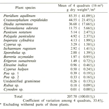
Table 3. Quantitative analysis of species composition of the plants (above the ground surface) in 4 quadrats (2m X2m each) in the old field, Plot 1, 5 months after abandonment; the dates of sampling, January 9 and 10, 1985.
Plant species Mean of 4 quadrats (16 m2)
g dry weight*/m2 Pteridium aquilinum 85.35 41.09%) Crassocephalum crepidioides 44.55 21.45%) Diodia sarmentosa 36.68 17.66%) Chromolaena odorata 11.75 5.66%) Panicum notatum 5.14 2.47%) Polygala paniculata 4.92 ' 2.37%) Imperata cylindrica 4.13 ' 1-99%) Cyperus sp. 3.29 1.58%) Ischaemum rugosum 2.92 1.41%) Sporobolus sp. 2.88 1.39%) Borreria ocymoides 1.97 0.95%) Erigeron sumatrensis 1.49 0.72%) Eleusine indica 0.96 0.46%) Cyperus halpan 0.50 0.24%) Poa sp. 1 0.39 0.19%) Poa sp. 2 0.33 0.16%) Unidentified gramineae 0.26 0.13%) Rubus sp. 0.18 0.09%) Cynodon sp. 0.01 0.00%) Total 207.70 (100.01%)
Coefficient of variation among 4 quadrats, 33.4^ Excluding withered parts of those plants.
102 Nakano et al.: Study of Conservation in a Montane Region in Sumatra
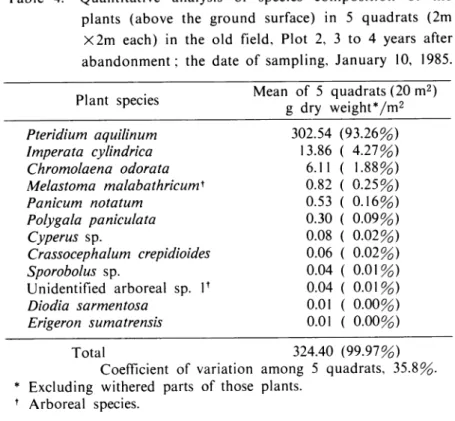
Table 4. Quantitative analysis of species composition of the
plants (above the ground surface) in 5 quadrats (2m
X2m each) in the old field, Plot 2, 3 to 4 years after abandonment; the date of sampling, January 10, 1985.
_. . Mean of 5 quadrats (20 m2)
Plant sPecles
gdry weightym*
Pteridium aquilinum 302.54 (93.26%) Imperata cylindrica 13.86 ( 4.27%) Chromolaena odorata 6.11 ( 1.88%) Melastoma malabathricum* 0.82 ( 0.25%) Panicum notatum 0.53 ( 0.16%) Polygala paniculata 0.30 ( 0.09%) Cyperus sp. 0.08 ( 0.02%) Crassocephalum crepidioides 0.06 ( 0.02%) Sporobolus sp. 0.04 ( 0.01%) Unidentified arboreal sp. V 0.04 ( 0.01%) Diodia sarmentosa 0.01 ( 0.00%) Erigeron sumatrensis 0.01 ( 0.00%) Total 324.40 (99.97%)
Coefficient of variation among 5 quadrats, 35.8%. * Excluding withered parts of those plants.
f Arboreal species.
ii. Quantitative data
Tables 3-6 quantitatively demonstrate the species compositions on the basis of above-ground biomass at Plots 1-4. Bracken were becoming the distinctly dominant species at Plot 1 even five months after abandonment (Table 3) and accounted for more than 90 % of the total above-ground biomass in three to four years after abandonment (Table 4). The number of species found in the quadrats appears to decrease in a few years after abandonment (Tables 3 and 4). In most cases, however, it seemed to increase again in several years (Tables 5 and 6). At Plot 4, the vegetation was physiognomically changing from the serai stage into a thicket (Table 6) where arboreal species accounted for much more than 70 % of the total above-ground biomass and the growth of bracken
appeared to be gradually decreasing. It should be noted that the dominant species
at Plot 4, Melastoma malabathricum, is usually regarded as one of the fire-resistant species. This suggests that Plot 4 had also undergone some fires, though not destructive, as the informants told us. It is noticeable that the vegetational succession to a secondary forest was proceeding there despite the fires. However, the recovery rate of above-ground biomass at Plot 4 extremely slow compared with other similar data obtained in the humid tropics in the rest of the world (UHL, 1987).
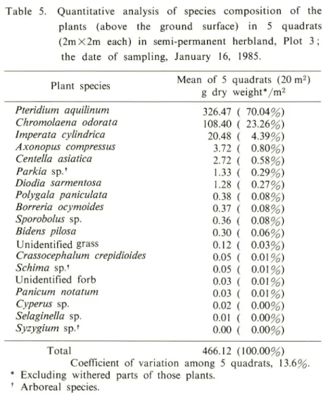
Table 5. Quantitative analysis of species composition of the plants (above the ground surface) in 5 quadrats (2mX2m each) in semi-permanent herbland, Plot 3;
the date of sampling, January 16, 1985.
Plant species Mean of 5 quadrats (20 m2)
g dry weight*/m2 Pteridium aquilinum 326.47 70.04%) Chromolaena odorata 108.40 23.26%) Imperata cylindrica 20.48 4.39%) Axonopus compressus 3.72 0.80%) Centella asiatica 2.72 0.58%) Parkia sp.f 1.33 0.29%) Diodia sarmentosa 1.28 0.27%) Polygala paniculata 0.38 0.08%) Borreria ocymoides 0.37 0.08%) Sporobolus sp. 0.36 0.08%) Bidens pilosa 0.30 0.06%) Unidentified grass 0.12 0.03%) Crassocephalum crepidioides 0.05 0.01%) Schima sp.t 0.05 0.01%) Unidentified forb 0.03 0.01%) Panicum notatum 0.03 0.01%) Cyperus sp. 0.02 0.00%) Selaginella sp. 0.01 0.00%) Syzygium sp.* 0.00 0.00%) Total 466.12 (100.00%)
Coefficient of variation among 5 quadrats, 13.6%. * Excluding withered parts of those plants.
f Arboreal species.
(Table 5) although its relative value of the above-ground biomass is somewhat lower than that at Plot 2. However, it seems noteworthy that Chromolaena odorata has become a quantitatively important species there and has partially surpassed the bracken in height. In a few quadrats, the tallest plants were C. odorata. This phenomenon appears to indicate the beginning of growth retardation of the bracken there. Attention should be paid that the value of the coefficient of variation of the above-ground biomass at Plot 3 is smaller than similar ones at any other plots (Tables 3-6). This implies that the distribution of above-ground biomass there is more spatially even.
Table 7 shows the matrix of the values of percent similarity of the species compositions (GOODALL, 1982) and their inverses between any two of Plots 1-4 on the basis of Tables 3-6. This table demonstrates that the vegetation of Plot 4 is strikingly different from that of any other plots, especially Plot 2. This conclusion can be visually displayed by Fig. 6. For such purpose, the inverse of percent
104 Nakano et al.: Study of Conservation in a Montane Region in Sumatra
Table 6. Quantitative analysis of species composition of the plants (above the ground surface) in 5 quadrats (2mX2m each) in the old field, Plot 4, 8 to 9 years after abandonment; the dates of sampling, January 22 and 23, 1985.
Plant species Mean of 5 quadrats (20 m2)
g dry weight*/™2 Melastoma malabathricum1 416.74 ( 34.79%) Unidentified arboreal sp. 2f 230.01 ( 19.20%) Rhodoleia champion^ 197.32 ' 16.47%) Pteridium aquilinum 174.04 |' 14.53%) Chromolaena odorata 63.86 1' 5.33%) Vaccinium sp. t 38.78 1' 3.24%) Sacchamm spontaneum 21.59 l' L80%) Axonopus compressus 21.58 ( 1.80%) Dicranopteris linearis 7.61 ( 0.64%) Asplenium sp. 1 5.81 ( 0.49%) Diodia sarmentosa 4.80 ( 0.40%) Diospyros sp.t 4.58 ( 0.38%) Asplenium sp. 2 3.45 ' 0.29%) Unidentified arboreal sp. 3* 1.65 { 0.14%) Timonius stipulobus1 1.33 1I 0.11%) Imperata cylindrica 1.28 1' 0.11%) Poa sp. 3 0.99 |' 0.08%) Lobelia angulata 0.63 l' 0.05%) Sporobolus sp. 0.48 : 0.04%) Centella asiatica 0.35 ( 0.03%) Cyperus sp. 0.22 ' 0.02%) Nephrolepis sp. 0.16 lI 0.01%) Breynia sp.t 0.16 |! 0.01%)
Unidentified arboreal sp. 4f (seedlings) 0.10 1' 0.01%)
Panicum notatum 0.08 |' 0.01%)
Tree seedlings (various spp.V 0.07 |; 0.01%)
Panicum repens 0.06 1' 0.01%)
Lycopodium complanatum 0.01 1' 0.00%)
Zingiber officinale 0.01 i: 0.00%)
Polygala paniculata 0.00 1' 0.00%)
Total 1197.75 (100.00%)
Coefficient of variation among 5 quadrats, 69.4%. * Excluding withered parts of those plants.
1 Arboreal species.
similarity rather than the original index seems to be more useful. The inverse can present a quantitative index which expresses the difference of the species compositions between the two plant communities.
Table 7. Matrix of percent similarities of the species compositions and their inverses (figures in the parentheses) between the
sampling plots on the basis of the
above-ground biomass. Plot no. 1 2 3 4 1 45.26% (2.21) 49.28% (2.03) 20.45% (4.89) 2 76.30% (1.31) 16.81% (5.95) 3 21.12% (4.73) 4
Table 8. Comparison of the relative light intensity between the plant communities at Plots 3 and 4; the dates of measuring, March 30 and April I, 1986.
Plant community ~~~~~—-—_____(no. of measuring "-—--^^Doints) Measuring " "~—-~ height in the community Plot 3 (43) Plot 4 (41) mean+s. d. (range) mean + s. d. (range) 150 cm above ground surface 32.8% ±20.8 (6.0-89.5%) 26.0%+13.8 (4.6-55.4%) 90 cm above ground surface 8.0%+ 5.4 (2.2-25.4%) 10.1%+ 7.0 (1.4-32.0%) 10 cm above ground surface 2.1%+ 1.3 (0.3- 6.1%) 2.4%+ 1.7 (0.3- 6.7%)
greatly different from that of Plot 2 despite some signs of vegetational succession mentioned above. In order to examine what factors hindered the advancement of the vegetational succession at Plot 3, the light conditions in the plant communities at Plot 3 and 4 were investigated. Table 8 embodies the results of this investigation. The data in this table do not seem to indicate a sharp difference in the light
106 Nakano et al.: Study of Conservation in a Montane Region in Sumatra
Fig. 6. Visual representation of the quantitative differences in the species compositions of vegetation between the sampling plots. The figures in circles are the plot nos. The figures beside the lines connecting the plot nos. are the inverses of the values of percent similarity between any two plots. The distances between any two plots are almost proportional to the values of the inverses of the percent similarity on the basis of above-ground biomass. The arrows indicate the order (from the least to the most) of the above-ground biomass at the respective plots.
conditions between the two plant communities. No statistcally significant differences in the three pairs of mean values of relative light intensity between the two plant communities were found. Furthermore, the maximum value of relative light intensity at the community floor may be more important than the mean value when we consider the conditions for the advancement of vegetational succession, since a seedling can grow at an extraordinarily favorable spot regarding light conditions. In this respect, the maximum value of the relative light intensity at 10 cm above ground level of Plot 3, more than 6 %, is considered to be enough for a tree seedling to grow even though slowly. In conclusion, the light factor cannot be regarded as crucial one of the unknown factors to hinder the vegetational succession
Water Quality
We here report the results of the water quality evaluation of the three lakes, their inflows, and their outflows using the numerical evaluation method, which has been developed by WATANABE et al. (1983, 1984, 1985, 1986b, and 1986c), on the basis of the epilithic diatom assemblage (Diatom Assemblage Index—DAIpo).
1. Materials and methods
During the surveys for this study, samples of attached algae were collected from the upper surfaces of submerged stones in the riffles of streams and the
sides of submerged substrata close to the lake coasts. A survey was made at
the 14 points shown in Fig. 7 from December 7 to 9, 1984. Concerning Lake
Talang, additional samples were obtained on September 21 and 22, 1985.
Samples were carried to the laboratories of Andalas University and Nara Women's University, and each was cleaned with sulfuric acid and potassium permanganate and mounted in Caedax.
The samples were examined using a microscope with Normarski accessories under 1000X oil immersion. Each taxon was photographed for identification. Counting 400 diatom frustules were carried out with respect to each slide in order to determine the percent relative abundance. Species were identified on the basis of the descriptions by HUSTEDT (1927-1966, 1930, 1936, 1937-1939, 1939, and
1942), K.RAMMER (1982), KRAMMER and LANGE-BERTALOT (1986), PATRICK
and REIMER (1966 and 1975), GASSE (1986), CLEVE-EULER (1951-1955), SCHMIDT (1874-1959), FOGED (1971, 1976, 1978, and 1984), WATANABE et al. (1986a), HARTLEY (1986), and VAN LANDINGHAM (1967-1979).
A numerical and biological index to indicate the degree of organic pollution of flowing water has been developped by WATANABE et al. (1985, 1986a, and 1986b), and has been applied to the lentic environment by WATANABE and
KANECHIKA (1986). This index (DAIpo) can be calculated by the following
equation :
m n
DAIpo = 100 - S Si - 1/2 I Ej
1=1 j-l
where (jt Si = sum of relative abundance values (%) of saprophilous taxa from 1 to m ; f Ej = sum of relative abundance values (%) of eurysaprobic taxa from 1 to n. The maximum value of DAIpo is 100 which represents the most oligotrophic condition.
In this study, the water quality at each sampling point is expressed in the DAIpo marks based on the species component of the assemblage of attached diatoms there. Some methodological problems which arose in this study are as follows :
108 Nakano et al. : Study of Conservation in a Montane Region in Sumatra
a. The comparison of water qualities of the three lakes between one and another is one of the purposes of this study. However, the DAIpo marks obtained from the samples from the lake coasts show merely littoral water qualities. In order to obtain the representative value of the water quality of a lake, it is necessary to collect the samples from offshore substrata (WATANABE, 1976; HlGO and WATANABE, 1978). In this study, we could actually find no offshore substratum
with periphyton in those lakes. In such cases, this difficulty was solved by regarding
the DAIpo value in the outflow as the representative value of the lake water. b. A few tropical diatom taxa occurred abundantly at some sampling points. Ecological knowledge of these taxa in connection with organic water pollution
is not yet obtained.
It can be considered that the taxa which are frequently
found in close proximity to one another react similarly to the water environment
(WATANABE et al, 1986b and 1986c). Based on this idea, we studied the ecological
characteristics of the tropical taxon compared with those of the dominant taxon of which something is known. Consequently, we regarded the six taxa, Cymbella ruttneri, Cym. muellerii, Cym. sumatrensis, Denticula vanheurcki, Den. pelagica, and Synedra rumpens var. fragilarioides as the saproxenous taxa.
2. Results
i. Physico-chemical features and phytoplankton
Table 9 shows the physico-chemical features of the two lakes obtained by the staff of Pusat Studi Lingkungan Hidup Universitas Andalas (1984). SAKAMOTO (1966) provided the range of nitrogen contents from 0.5 to 1.3 ppm for eutrophic lakes. In regard to phytoplankton flora, Aulacoseira granulata var. angustissima is dominant in Lake Dibaruh, whereas, in Lake Diatas, Synedra rumpens is dominant followed by Aulacoseira granulata var. angustissima. Aulacoseira granulata var. angustissima occurs abundantly in eutrophic lakes in Japan, for instance, Lake Suwa, Lake Mikata, Lake Koyama, and the southern basin of Lake Biwa. Synedra
rumpens is widely distributed in abundance in oligotrophic to eutrophic lakes Table 9. Physico-chemical features of Lake Diatas and Lake Dibaruh.
Lake Diatas Lake Dibaruh
August November August November
pH 7.40-7.70 7.85-7.90 7.30-7.45 7.75-7.85 Transparency (m) 6 5.5 6.3 5.8 BOD (ppm) 1.00-1.60 1.00-1.60 2.00-3.20 1.20-2.80 COD (ppm) 2.80-3.41 2.83-3.79 4.26-6.37 4.33-5.96 T —N (ppm) 2.07-2.42 0.70-0.90 1.40-1.72 0.90-0.93 T-P (ppm) 0.19-0.20 0.19-0.20 0.18-0.20 0.18-0.21
Table 10. Relative abundance of each taxon in attached diatom assemblage of Lake Diatas, outflow, and inflow, and DAIpo value at each sampling point. Sampling point Achnanthes lanceolata (Breb.) Grun. var. lanceolata Ach. minutissima Kutz. var. minutissima Amphora montana Krasske Aulacoseira granulata var. valida (Hust.) Simonsen Brachysira vitrea (Grun.) R. Ross Cymbella gracilis (Rabh.) Cl. Cym. microcephala Grun. Cym. minuta Hilse ex Rabenh. Cym. muellerii Hust. var. muellerii Cym. sinuata f. ovata Hust. Cym. sumatrensis Hust. Cym. turgida Greg. Denticula pelagica Hust. Den. vanheurcki Brun. var. vanheurcki Epithemia adnata (Kutz.) Breb. var. adnata Epi. sorex Kutz. var. sorex Fragilaria construens (Ehr.) Grun. var. construens Fra. fragilarioides (Grun.) Choln. Fra. pinnata Ehr. var. pinnata Fra. pinnata var. lancettula (Schum.) HUST. Gomphonema clevei Fricke Gom. parvulum (Kutz.) var. parvulum Gom. vibrio var. maior Gom. vibrio var. pumilum (Grun.) R. Ross Navicula adnata Hust. Nav. atomus (Kutz.) Grun. var. atomus Nav. bryophila J. B. Petersen Nav. cryptocephala var. exilis Grun. Nav. cryptotenella Lange-B. Nav. elginensis (Greg.) Ralfs var. elginensis Nav. erifuga Lange-B. Outflow 7.5 0.4 1.9 2.3 13.6 0.8 2.6 7.9 1.1 4.9 1.5 11.7 12.1 0.8 7.2 3.8 Inflow 2 2.0 0.7 1.4 4.8 39.8 8.2 Lake 3 4 5 6 7 z > 4.2 -20.2 5.5 4.8 > o -1.1 0.8 -21 _ _ 3.4 1.7 -C£ 5.8 -11.2 58.5 23.3 -1.2 -o -0.6 0.6 0.8 9.3 o 1.1 — 5.1 3.0 10.6 o 3 CD 5.8 -0.6 -< -7.3 -o" 21.6 -12.7 13.7 -. -2.8 -(£ 1.6 0.6 1.7 -2.6 2 1.6 -3 1.1 10.6 2.2 0.4 24.2 fa 3 5.3 3.0 5.6 7.6 0.9 73 -0Q# o' 3 _ 4.8 _ _ _ 3* GO C 40.0 -2.2 -3 1.8 0.6 0.6 1.1 1.1 0.4
Navicula exigua Greg. -. -0.6 -Nav. gregaria Donk. var. gregaria -1.7 0.5 -Nav. lanceolata (Ag.) Kutz. -0.4 Nav. menisculus Schum. -3.0 -Nav. minima Grun. -10.2 1.6 12.7 0.6 -Nav. minuscula Grun. -1.1 -Nav. pseudobryophila Hust. -0.3 -Nav. pupula Kutz. var. pupula -0.3 -Nav. radiosa Kutz. var. radiosa -1.1 -1.7 3.0 1.3 Nav. schoenfeldii Hust. -0.6 -Nav. schroeterii Meister -0.3 -Nav. seminulum Grun. -9.5 -Nav. terminata Hust. -0.4 -Nav. thienemannii Hust. -0.6 -Nav. veneta Kutz. -6.7 -2.2 Nav. vitabunda Hust. -0.7 -0.6 -Nitzschia amphibia Grun. 0.4 -1.6 1.2 -Nit. archibaldii Lange-B. -0.3 -Nit. baccata Hust. 0.4 -1.7 1.3 -Nit. frustulum (Kutz.) Grun. -1.4 2.6 66.7 1.7 -Nit. kuetzingiana Hilse -1.7 -Nit. palea (Kutz.) W. Sm. -18.0 -6.2 -Nit. paleacea Grun. -0.6 -Nit. subacicularis Hust. 0.4 -5.6 -Nit. tenuis W. Sm. -0.5 -Opephora martyi Herib. -0.5 -1.7 0.4 -Pinnularia interupta W. Sm. -0.3 -Rhopalodia parallela (Grun.) O. Mull. var. parallela -0.6 0.4 2.2 Synedra fasciculata (Ac) Kutz. -0.4 -Syn. rumpens var. fragilarioides Kutz. 13.2 -4.5 2.5 7.0 Syn. ulna (Nitz.) Ehr. 2.6 -Syn. ulna var. claviceps Hust. 0.8 -Syn. ulna var. danica (KUTZ.) V. H. I.I -Syn. sp. 1.1 -~ -DAIpo 81 31 65 47 69 90 94
Table 11. Relative abundance of each taxon in attached diatom assemblage of Lake Dibaruh, outflow, and inflow, and DAIpo value at each sampling point.
Sampling
point
Outflow Inflow LakeSpecies
8 9 10 11 Achnanthes exigua Grun. -0.4 Ach. lanceolata (Breb.) Grun. var. lanceolata -1.3 -Ach. minutissima Kutz. var. minutissima 7.1 0.8 13.1 7.2 Amphora montana Krasske -3.4 -Amp. ovalis var. pediculus (Kutz.) V. H. -1.3 -Aulacoseira distans (Ehr.) Simonsen -1.1 Aul. italica (Ehr.) Simonsen -3.4 -2.7 Cocconeis placentula var. euglypta (Ehr.) Cleve 0.4 -0.5 -Cymbella gracilis (Rabh.) Cl. var. gracilis 0.7 -Cym. minuta Hilse ex Rabenh. -0.4 -Cym. microcephala Grun. 3.2 -Cym. muellerii HUST. var. muellerii 1.8 -Cym. sumatrensis Hust. 9.6 -17.3 5.4 Cym. tumida (Breb. ex Kutz.) V. H. 0.4 -Denticula pelagica Hust. 6.7 -8.4 21.1 Den. vanheurcki Brun. 3.9 -Epithemia adnata (Kutz.) Rabenh. var. adnanta 1.1 -1.4 0.4 Epi. sorex Kutz. var. sorex 4.6 -13.1 1.9 Epi. turgida var. sumatraense var. nov. -0.5 0.4 Fragilaria construens (Ehr.) Grun. var. construens 22.3 0.8 -Fra. fragilarioides (Grun.) Choln. 4.6 5.6 1.4 -Fra. pinnata Ehr. var. pinnata 7.4 2.1 4.2 2.7 Fra. pinnata var. lancettula (Schum.) Hust. 2.8 -0.9 -Gomphonema angustatum var. citrea (Hohn & Hellerm) Patr. 4.3 -8.9 -Gom. clevei Fricke 0.7 -Gom. grunowii Patr. -0.4 -Gom. parvulum (Kutz.) var. parvulum -8.2 0.5 0.8 Gom. undulatum HUST. -1.4 -Gom. vibrio var. maior -8.4 z > > z o I. o 2 o 3 s 3n> 73Navicula atomus var. permitis (Hust.) Lange-B. -0.8 -Nav. cryptotenella Lange-B. -50.6 -Nav. minima Grun. -1.7 -Nav. mutica Kutz. -1.1 Nav. pupula Kuth. var. pupula -0.5 -Nav. schroeterii Meister -7.7 -Nav. seminuloides Hust. -0.9 0.5 -Nav. seminulum Grun. -3.4 0.5 -Nav. submuralis Hust. -0.9 -Nav. veneta Kutz. -0.9 10.3 Nav. sp. -0.4 Nitzschia amphibia Grun. 0.7 -0.9 -Nit. archibaldii Lange-B. -0.4 -Nit. baccata Hust. 2.5 -11.7 -Nit. fonticola Grun. -0.8 Nit. frustulum (Kutz.) Grun. 0.4 -0.5 0.4 Nit. kuetzingiana Hilse -1.1 Nit. obtusa var. scalpelliformis Grun. -0.4 0.9 -Nit. palea (Kutz.) W. Sm. -5.2 0.5 -Nit. tenuis W. Sm. -1.5 Pinnularia microstauron (Ehr.) Cleve 0.4 -Rhopalodia gibberula var. vanheurckii O. Mull. -0.5 -Surirella linearis W. Sm. -0.4 Synedra delicatissima W. Sm. var. delicatissima 10.3 -6.5 26.8 Syn. dorsiventralis O. Mull. -0.4 -Syn. rumpens var. familiaris (Kutz.) Grun. -2.7 Syn. ulna (Nitz.) Ehr. 1.1 0.4 -1.1 Syn. ulna var. claviceps Hust. 1.4 -0.4 DAIpo 73 45 80 71
]M Nakano et al. : Study of Conservation in a Montane Region in Sumatra
(WATANABE, 1984). These facts indicate that both Lakes Dibaruh and Diatas
could be eutrophic lakes.
On the other hand, the values of transparency (Table 9) of the two lakes
are rather similar to those obtained in oligotrophic lakes. Morever, the amount
of standing crops of phytoplankton in those lakes is small. That is, they have
Fig. 8. Scenes around the three lakes. 8-1, the northern coast of Lake Diatas; 8-2, the outflow of Lake Diatas; 8-3, a view of the hills at the eastern side of Lake Dibaruh from its western side; 8-4,
the outflow of Lake Dibaruh ; 8-5, a view of Mt. Talang and Lake Talang from its southeastern shore; 8-6, an inflow of Lake Talang.
Table 12. Relative abundance of each taxon in attached diatom assemblage of Lake Talang and its inflow, and DAIpo value at each sampling point.
Species Sampling point
Achnanthes minutissima Kutz. var. minutissima Aulacoseira granulata (Ehr). Simonsen
Brachysira brebissonii R. Ross
Bra. serians (Breb. ex Kutz.) Round et Mann Bra. vitrea (GRUN.) R. Ross
Cymbella gracilis (Rabh.) Cl. var. gracilis
Cym. microcephala Grun.
Cym. sumatrensis HUST. Cym. turgida Greg.
Denticula vanheurcki Brun.
Diploneis smithii var. dilatata (M. Perag.) Boter
Epithemia sorex Kutz. var. sorex
Eunotia curvata (Kutz.) Lagerst. var. curvata
Eun. monodon var. constricta Cl.
Eun. pectinalis (Kutz.) Rabenh. var. pectinalis
Eun. spp.
Fragilaria fragilarioides (Grun.) Choln.
Fra. pinnata var. lancettula (Schum.) Hust.
Frustulia rhomboides (Ehr.) De Toni var. rhomboides
Fru. rhomboides var. saxonica (Rabh.) De Toni
Gomphonema undulatum Hust.
Gom. vibrio var. pumilum (Grun.) R. Ross
Navicula acceptata Hust.
Nav. cryptotenella Lange-B.
Nav. gallica var. laevissima (Cleve) Lange-B. Nav. ignota Krasske
Nav. minuscula Grun. var. minuscula
Nav. radiosa Kutz.
Nav. seminulum Grun.
Nav. subtilissima Cleve
Nitzschia tenuis W. Sm.
Pinnularia borealis var. rectangularis Carlson
Pin. microstauron (Ehr.) Cleve
Pin. microstauron f. minores Foged
Surirella delicatissima Lewis
Sur. linearis var. helvetica (Brun.) Meister
Synedra delicatissima W. Sm. var. delicatissima DAIpo Inflow Lake 12 13 14 - 36.0 35.8 0.6 3.4 7.4 - 3.4 1.1 0.6 - -0.6 3.4 8.5 0.6 1.1 0.6 4.6 6.8 5.7 - 6.1 2.8 - 0.4 -- 18.6 8.5 - - 0.6 - 0.4 -51.4 - -1.7 0.8 0.6 15.3 - -1.7 - -- 3.8 7.4 - 1.9 -- 0.8 0.6 14.7 0.6 4.5 1.1 1.7 99 5.3 4.0 - 4.5 - 1.1 - 0.6 - 1.7 0.4 2.3 - 1.1 0.4 -0.4 -0.4 -4.2 2.3 74 71
116 Nakano et al.: Study of Conservation in a Montane Region in Sumatra
also the characteristics of oligotrophic lakes. Such contradiction stated above, however, will be explained later.
ii. Pollution degree based on DAIpo marks
In Lake Diatas, 7 samples including those from an inflow and the outflow were collected (Fig. 7). We show the diatom taxa found at each point using their values of relative abundance (Table 10). DAIpo marks were calculated from the diatom assemblages in Table 10.
The DAIpo value of the outflow of this lake is 81. This value proves that the lake water is so clean that it is equivalent to the /^-oligosaprobic degree in
saprobic system (WATANABE et al, 1986c).
The DAIpo value of the outflow
can provide a criterion for water pollution degree of the lake. However, considerable
differences were found among the values at the sampling points as shown in Table 10. The DAIpo marks at the southern points (6 and 7) are very high although the marks at the northern (3) and western points (4 and 5) are comparatively low. The marks of the former indicate that the water pollution degree near the southern points is xenosaprobic (very clean), and the degrees of the latter points are oligosaprobic (clean). The water pollution of the inflow is unexpectedly serious and its DAIpo value was 31 (tf-mesosaprobic).
From these results, we must conclude that the lake water is clean as a whole although the inflow and the littoral zone adjacent to the cultivated lands or villages are polluted owing probably to the agricultural effluent or domestic sewage.
In Lake Dibaruh, 4 samples were collected (Fig. 7). As shown in Table 11, the saprobic degree of Lake Dibaruh expressed in DAIpo value (73) is
J3-oligosaprobic with regard to its outflow. The diatom species of Cymbella sumatrensis
and Synedra rumpens var. fragilarioides belonging to saproxenous taxa occurred abundantly in the outflow of Lake Diatas. On the other hand, in Lake Dibaruh,
Fragilaria construens, Synedra delicatissima, which are eurysaprobic taxa, and
Cymbella sumatrensis were found in abundance. These facts also suggest that
Lake Dibaruh is more eutrophicated than Lake Diatas. Concerning Lake Dibaruh, the inflow passing through the cultivated fields is polluted up to the /?-mesosaprobic degree.
In Lake Talang, we could find only one small stream (Fig. 8-6) passing through carabao grazing land and could not find any other sources of artificial
pollution.
As shown in Table 12, acidophilous taxa in Eunotia and Frustulia
were abundant in periphyton in the inflow. The high DAIpo value of the stream does not always rule out the non-organic pollution because of its acidification. The saprobic degree of this lake was /^-oligosaprobic based on the DAIpo marks of attached forms at the littoral zone.
Discussion
Although detailed comparisons of the degrees of organic pollution among the three lakes were impossible because of the insufficient number of samples, we can compare the amount of pollution of Lake Diatas with that of Lake Dibaruh using the DAIpo value of the outflow from each lake.
Based on the DAIpo marks (Tables 10 and 11) of the outflows, it has been revealed that Lake Dibaruh is more eutrophicated than Lake Diatas. The differences of BOD and COD values (Table 9) and diatom flora between the two lakes also support this conclusion.
The ratio of the land area of the catchment basin of Lake Dibaruh to the lake surface area is 1.88km2/km2 (Table 2). This value is far smaller than that for Lake Diatas, 2.65 km2/km2 (Table 2). It is therefore considered that the load of pollutants to Lake Diatas is larger. Moreover, the maximum depth of Lake Dibaruh is greater than that of Lake Diatas (Table 1). Greater depth is one of the strong factors controlling the eutrophication of stagnant water.
When we reflect these respects, Lake Dibaruh should not be more easily eutrophicated than Lake Diatas. This simple theory appears to be in conflict with the data obtained in this study. We, however, consider that this contradiction
can be resolved.
As earlier stated, the populations in the two catchment basins are about 6,500
around Lake Diatas and 5,000 around Lake Dibaruh and almost one hundred
percent of the inhabitants are engaged mainly in agricultural activities. In addition, such fertilizers as TSP, urea, and KCI are ubiquitously used. The factors of the differences of populations, population densities (Fig. 4) and the absolute quantities of fertilizer consumption between these catchment basins are considered
rather small.
The difference, though not very great, of the degree of eutrophication between the two lakes is probably due chiefly to the topographic features around them. As earlier stated, Lake Dibaruh is surrounded directly by very steep slopes (Figs. 3 and 8-3) where many consecutively and intensively cultivated fields have been developed (Fig. 8-3). By contrast, Lake Diatas is mostly surrounded by gentle or moderately steep slopes. Necessarily, the severity of the erosion of surface soil and the runoff in which mineral nutrients derived from fertilizers is greater on the lands around Lake Dibaruh than around Lake Diatas. This difference must effect the arrival rates of the pollutants into the lakes and therefore cause the contradiction between the above-mentioned theory and the actual water quality. From the results of the chemical analyses (Table 9) of the lake water and the accumulated ecological knowledge of plankton flora, we must conclude that both Lake Diatas and Lake Dibaruh are eutrophic lakes. This conclusion, however,
118 Nakano et al.: Study of Conservation in a Montane Region in Sumatra
contradicts the high DAIpo marks of the outflows which were regarded as the respective representatives of the water quality of these lakes.
We discuss some points of the problem based on the difference of water temperature between the inflow and the lake water. As shown in Table 13, the water temperature of the inflow was about 1°C higher than that of lake water
in each lake. Moreover, the inflows to both Lake Diatas and Lake Dibaruh
are considerably polluted. From these facts, we deduce that the polluted water
from an inflow does not become an undercurrent, but diffuses on the surface
of the lake. On the other hand, there is a strong probability that suspended substances flowing into the lake sink to the shallow bottom of the littoral zone and only pollute the water near the lake shore. The low DAIpo marks of northern and western littoral zones near the villages or cultivated fields in Lake Diatas must be caused by such a process.
Synthesizing the DAIpo marks of the two lakes and this discussion, we explain the above-mentioned contradiction as follows:
The eutrophication of the littoral zone and the thin layer of surface water near inflows and cultivated fields or villages is connected with the results of the chemical analyses of lake water, plankton flora and low DAIpo marks at some littoral points. By contrast, the average water quality of the whole lake is indicated by the high DAIpo marks of the outflows, low turbidity, and small standing crops of phytoplankton.
At any rate, it is noteworthy that the manifest symptoms of eutrophication of the water in the two lakes have been, even though partially, observed. Such symptoms are perhaps partly due to considerably high levels of population density (Fig. 4) around these lakes and ubiquitous application of chemical fertilizers to
Table 13. Water temperature (WT), electric conductivty (EC), and DAIpo value at each sampling point.
Lake Diatas Lake Dibaruh Lake Talang
Statiorl WT EC Station WT EC Station WT EC
n o . (°C) (uU) DAIpo n o . (°C) (uU) DAIpo n o . (°C) (uU) DAIpo
Outflow 1 20.5 76 81 8 18.5 85 73 - - - -Inflow 2 21.5 58 31 9 19.2 65 45 12 21.5 16 (99) Lake coast North 3 - 65 -_ - - - -West 4 20.8 77 49 10 18.0 78 80 13 20.5 27 71 100m off Western shore 5 - 69 11 71 - - - -South 6 21.0 90 -_ 14 20.5 27 74 Southeast 7 - 94 - - -
-the both wet paddy and upland fields. If, in the process of the resort development, no satisfactory measures for the prevention of eutrophication are taken, the consequence will be the deterioration of the water quality. Furthermore, if the fertilizer consumption around those lakes rises without taking measures for abating the rates of soil erosion and runoff, similar consequences can be foreseen. In this sense, the most desirable measures would be to stop entirely the utilization of the steep slopes, such as those around Lake Dibaruh, for agricultural activities
though realistically very difficult, and to restore them to natural forests. As a
feasible first step, most ecologists would affirm the importance of the recovery of natural forests in the old fields which had been abandoned for many years. The question then arises whether the natural forests would re-cover such old fields without human assistance. Of course, the positive answer is more desirable because the cost of promotive measures often imposes a heavy burden on a society. According to the quantitative data shown earlier (Tables 3-6), in a long fire-free period, vegetational succession up to forests seem to proceed naturally in such abandoned fields around the lakes in many cases even though it may take many years for natural forests to establish themselves firmly. Even at the previously mentioned Plot 3 which reportedly remained barren for a few decades, Chromolaena odorata (Eupatorium odoratum) partially surpasses bracken. In a study of the vegetational succession in Imperata cylindrica (alang-alang) grassland in the southernmost Province of Sumatra, EUSSEN and WIRJAHARDJA (1973) wrote, "The first stages of succession from an alang-alang vegetation to a secondary forest are therefore characterised by the occurrence of E. odoratum (p. 24)." If this is true, the recovery of a natural forest at Plot 3 of this study is not hopeless even though very slow. In SCOTT'S (1978) case in a lower montane region of Peru, a similarly optimistic conclusion was drawn. After all, the most basic way to promote the restoration of a natural forest at the least cost in the barren lands of our study area as well as many other regions in the humid tropics, seems to be the prevention of fires insofar as the data having been hitherto obtained can suggest.
Acknowledgments
We wish to acknowledge the invaluable favor bestowed by the Japan Society for the Promotion of Science, the Mitsubishi Foundation, and Tokyo Geographical Society for their grants. We wish express our deep gratitude to Emer. Professor
Syunzo KAWAMURA (Kyoto University) and Dr. Amsir BAKAR (Faculty of
Mathematics & Natural Sciences, Andalas University) for their efforts to promote this study. We also heartily thank Dra. Hasiana IBKAR-KRAMADIBRATA M. Sc. (Faculty of Mathematics & Natural Sciences, Bandung Institute of Technology)