韓国南部の農村地帯の水草相、および水草相と土地 利用・水質との関係
著者 Shimoda Michiko, Song Jong‑Suk
著者別表示 下田 路子, 宋 鍾碩
journal or
publication title
The journal of phytogeography and taxonomy
volume 60
number 2
page range 51‑65
year 2013‑03‑01
URL http://doi.org/10.24517/00053486
Creative Commons : 表示 ‑ 非営利 ‑ 改変禁止 http://creativecommons.org/licenses/by‑nc‑nd/3.0/deed.ja
Abstract
We carried out field research in the southern Korean Peninsula and Jeju Island, South Korea to describe the aquatic flora and its habitat of the Korean rural areas, including 32 sites in the peninsula and 16 sites on the island. The sites of the peninsula are irrigation ponds and reservoirs for rice fields. The sites of the island are ponds for the drinking water of domestic animals, and irrigation and washing of local people. The study sites with agriculturally intensive watersheds had high values of electric conductivity (EC) > 40 mS/m. We found 8 free-floating taxa, 9 floating-leaved taxa and 14 submerged taxa. Eleven taxa (e.g. Trapa japonica) were found in both areas. Thirteen taxa (e.g. Euryale ferox) were restricted to the peninsula. Seven taxa (e.g.
Potamogeton natans) were restricted to the island. Although most of the taxa were found in waters with vari- ous EC values, several species (e.g. Nymphoides indica) were confined to waters with EC < 30 mS/m. Most of the confirmed taxa in this study are found in Japan. The abundant species (e.g. T. japonica) commonly domi- nate in nutrient-rich ponds in Japan. The aquatic flora of the study area was characterized by species char- acteristic of a wide distribution and/or eutrophic water. The aquatic flora includes seven species regarded as threatened in Korea. It also includes 15 Japanese threatened species, and 9 of them are rice weeds. Our study shows that ponds of Korean rural areas support diverse aquatic plants including rare and threatened species.
Key words : irrigation pond, Jeju Island, Korean Peninsula, rice field, threatened species.
1Faculty of Social Environment, Tokoha University, 325 Obuchi, Fuji 417-0801, Japan: michiko_shimoda@nifty.
com (*corresponding author); 2Department of Biological Science, College of Natural Sciences, Andong National University, 388 Songcheon-dong, Andong, Gyeongbuk 760-749, Republic of Korea: [email protected]
Introduction
Rice has been the major crop cultivated in Korea and Japan for a long time. In both coun- tries, natural wetlands are very limited because many freshwater wetlands have been converted into fields for rice and other human uses. Re- cently, the importance and value of irrigated lands including rice fields, irrigation ponds and channels are emphasized from the viewpoint of biodiversity(Ministry of the Environment, Gov- ernment of Japan 2008).
In Japan, aquatic flora (e.g. Shimoda 1983, 2005a; Kadono 1984; Kunii 1991; Naka 2001) and vegetation (e.g. Shimoda 1985, 1986;
Kadono 1987) of irrigation ponds have been reported from various localities. The relation- ship between aquatic flora of irrigation ponds and pond water quality was also studied (e.g.
Hamashima 1983, 2008; Kunii 1991; Shimoda
and Hashimoto 1993; Shimoda 1997; Mineta and Hidaka 2002; Shimoda and Kagawa 2009). Thus there have been many studies on aquatic plants of irrigation ponds in Japan.
In South Korea, aquatic flora has been re- ported from large rivers (e.g. Chung and Choi 1981, 1983, 1985; Lee et al. 1987; Chung et al.
1989) and large-scale artificial lakes (e.g. Choi and Lee 1987; Kim et al. 1991; Lim et al. 2005;
Kang et al. 2007) of the Korean Peninsula.
Only a few studies on aquatic plants of small ponds have been carried out in the peninsula
(Chung and Choi 1987; Ji 2008). Therefore studies on aquatic plants of Korean irrigation ponds remain limited. A plant list of Jeju Is- land by Nakai (1914) included many aquatic and wetland plants. However, detailed study on aquatic plants of the island has not yet been conducted. In North Korea, although Kolbeck
Michiko Shimoda
1*and Jong-Suk Song
2: Aquatic flora of rural areas and its relation to land use and water quality in southern Korea
©The Society for the Study of Phytogeography and Taxonomy 2013
and Dostálek (1996) described aquatic plant communities of water basins, the aquatic flora and vegetation of the northern part of the Ko- rean Peninsula are little known.
To describe the aquatic flora and its habitat of the Korean rural area, we carried out field research in the southern Korean Peninsula and Jeju Island in August 2008. In this paper, we present the aquatic flora. We also discuss its distribution in relation to the environment, and the floral difference between the two study areas. Finally, we compare our results with
Japanese rural aquatic flora to clarify the char- acteristics of Korean rural aquatic flora.
Study sites
Figure 1 shows our 48 study sites: 32 sites in the southeastern part of the Korean Pen- insula (Fig. 1A, Appendix 1) and 16 sites on Jeju Island (Fig. 1B, Appendix 2). Sites 1-8 of the peninsula are situated in Gyeongsangbuk- do Province, and sites 9-32 are in Gyeongsang- nam-do Province. Annual mean temperatures of Daegu, Busan and Jeju are 14.1, 14.7 and
Fig. 1. Map of the southern Korea showing the study sites. A: Southeastern part of the Korean Peninsula, B:
Jeju Island.
15.8 ºC, and their annual mean precipitations are 1064.4, 1519.1 and 1497.6 mm respectively
(Korea Meteorological Administration 2011). According to Ramsar Convention on Wetlands
(2008), a pond is water body with its size be- low 8 ha, and a reservoir is generally over 8 ha. In our study area of the peninsula, numer- ous irrigation ponds and reservoirs are distrib- uted at the foot of hills and mountains, and on the plains. The study sites 1-32 are distributed from 5 to 130 m in altitude. Among them, 22 sites are irrigation ponds less than 8 ha, and 9 sites are reservoirs over 8 ha. The top three large reservoirs are site 29 of 285 ha, site 12 of 128 ha and site 28 of 75ha. Sites 23 and 24 were regarded as natural swamp by Chung and Choi (1987). However they are surrounded by embankments and arable lands, and not complete natural wetlands. All the study sites except site 22 were used for irrigation of rice fields. Some of them were used partially to ir- rigate upland cultivation such as orchards and vegetables. Site 22 was a ditch surrounded by cultivated and abandoned rice fields. Therefore all study sites in the peninsula were influenced by human activities, especially by agricultural activities.
Jeju Island is a volcanic island. On the is- land, rice fields are very limited because of the lack of irrigation water (Takano 1996). Many small ponds were constructed for the drinking water of domestic animals, irrigation for upland crops and washing of local people (Izumi 1966). Sites 33-48 are distributed from 6 to 331 m in altitude. The largest reservoir (34) is ca. 10 ha.
Most of the study sites are small ponds below 1 ha, and used for irrigation of upland crops and drinking of domestic animals. Site 37 is a small garden pond of a house. Site 48 is a ditch sur- rounded by rice fields.
Methods
We investigated aquatic plants and water quality on 2-6 August 2008 in the peninsula (Fig.
1A) and on 7-9 August 2008 on the island (Fig.
1B). Water temperature, electric conductivity
(EC) and pH of the surface water were mea- sured, because they are important factors that give an outline of the water quality (Japan So-
ciety for Analytical Chemistry, Hokkaido 1981). The measurements were carried out near the spillway of each pond and reservoir with por- table EC meter (Yokogawa SC72) and pH meter (Yokogawa PH71). Water quality was measured at more than one point at the sites of large areas (8, 12, 28, 29) and at the sites with different kinds of land uses and vegeta- tion in their watersheds (2, 4, 9-11, 32, 33). At sites 40 and 45 on the island, we could not measure water quality because there was no water there. We got measured values from 60 points in total (Appendixes 1, 2). Values of EC were calibrated at 25 °C.
Growth condition and distribution of each species within each site were recorded. “Aquatic plants” in this paper are the plants which were described in “Aquatic plants of Japan” (Kadono 1994). Besides the vascular plants in Kadono
(1994), we recorded Ricciocarpos natans (L.) Corda (bryophyte) and Chara braunii Gmelin
(charophyte) as aquatic plants. Species identifi- cation and nomenclature mainly follow Kadono
(1994). Identification of Vallisneria L. and Utricularia L. is according to Na et al. (2008a) and Na et al. (2008b), respectively.
Results
Environment and water quality of the study sites
The watersheds of study sites included for- ests, agricultural lands, houses and paved roads. Figure 2 shows the distribution of EC and pH values of the study sites. The average, minimum and maximum values of EC were 24.7 mS/m, 7.9 mS/m at sites 19, 39 and 55.2 mS/m at site 6 respectively. The average, mini- mum and maximum values of pH were 7.90, 6.18 at site 11 and 10.52 at site 47 respectively. All pH values of the island were more than 7.
Two sites (19, 39) indicated EC values less than 10 mS/m. Site 19 is situated at the foot of a mountain. Its watershed included forest, grassland and upland fields. Site 39 was sur- rounded by forest, grassland and paved road.
Among seven sites with EC > 40 mS/m, five sites (4, 6-8, 11) had watersheds partly forest- ed, but their watersheds were also occupied by rice fields, upland fields, orchards, paved roads
and houses. Other two sites (22, 33) had wa- tersheds without forest. Site 22 was surrounded by cultivated and abandoned rice fields. Site 33 was surrounded by paved road and upland fields. The sites with EC of 10-40 mS/m had watersheds including forests and diverse an- thropogenic environments such as grasslands, rice fields, upland fields, orchards, paved roads and factories.
Aquatic plants
Table 1 shows the plants found in the study sites. The species of Table 1 are arranged ac- cording to their life forms by Sculthorpe (1967) and Kadono (1994). The emergent species of the table include amphibious and emergent- wetland species by Kadono (1994).
Because certain species were difficult to iden- tify accurately without reproductive parts, some taxa were identified to genus only. Utricularia of the study sites was similar to Japanese U.
australis R. Br. (a synonym U. tenuicalis Miki). Na et al. (2008b) reported that U. tenuicalis is distributed widely, and U. japonica Makino, similar to U. tenuicalis, is very rare in Korea.
Therefore we tentatively assigned Utricularia in our study to U. australis. We confirmed two types of Vallisneria, V. asiatica Miki and the plant similar to V. denseserrulata (Makino) Makino. We regarded the latter as V. spinulosa S.
Z. Yan following the study of Na et al. (2008a). We found 8 free-floating taxa, 9 floating-
leaved taxa, 14 submerged taxa and 33 emer- gent taxa. Twenty-four taxa (e.g. Trapa japoni- ca Flerov) occurred in both areas. Twenty-three taxa (e.g. Euryale ferox Salisb.) were restricted to the peninsula. Seventeen taxa (e.g. Potamo- geton natans L.) were restricted to the island.
Therefore there is clearly a floristic difference between the two study areas. The aquatic flora of study sites includes 18 species designated as threatened in Korea and Japan. Categories of threatened species are shown in Table 1. Seven species are threatened in Korea, and 15 species are threatened in Japan. Four species among them are threatened in both countries.
Free-floating, floating-leaved and submerged species were called “true aquatic species” (Sed- don 1972). We found 31 true aquatic taxa at 42 sites: 30 sites in the peninsula and 12 sites on the islands. The remaining six sites contained only emergent taxa, and no true aquatic taxa.
Figure 3 shows the number of true aquatic spe- cies per site. Junam reservoir (site 29: 285 ha) contained 14 species, the largest number. The four sites of more than eight species were res- ervoirs with the area >10 ha in the peninsula.
Among the sites on the island, site 46 (0.5 ha), with the largest number of species, contained eight species. Floating-leaved Trapa japonica, Euryale ferox, Nymphoides indica (L.) O. Kun- tze, and free-floating Spirodela polyrhiza (L.) Schleid, Lemna paucicostata Hegelm., Hydro- charis dubia (Bl.) Backer, Salvinia natans (L.) Fig. 2. Electric conductivity (EC) and pH of study
sites. ○: Korean Peninsula, ●: Jeju Island.
Fig. 3. The number of true aquatic species per study site. True aquatic plants consist of free- floating, floating-leaved and submerged plants
(Seddon 1972), and were found in 42 sites.
Life form and species 和名 Threatened species categories Number of sites Korea1) Korea2, 4) Japan3, 4) Peninsula Jeju Total Free-floating
Surface-floating
Ricciocarpos natans イチョウウキゴケ NT 1 1
Salvinia natans サンショウモ NT 13 13
Hydrocharis dubia トチカガミ LC NT 14 14
Lemna paucicostata アオウキクサ 18 4 22
Spirodela polyrhiza ウキクサ 20 3 23
Wolffia globosa ミジンコウキクサ 1 1
Submerged free-floating
Ceratophyllum demersum マツモ 19 1 20
Utricularia australis イヌタヌキモ NT 3 3
Floating-leaved
Potamogeton natans オヒルムシロ 5 5
Potamogeton distinctus ヒルムシロ 3 3
Potamogeton cristatus コバノヒルムシロ VU 5 5
Euryale ferox オニバス II VU VU 8 8
Nymphaea sp. スイレン(園芸品種) 5 5
Trapa japonica ヒシ 27 9 36
Trapa natans var. japonica オニビシ 2 2
Nymphoides peltata アサザ NT 6 6
Nymphoides indica ガガブタ NT 3 4 7
Submerged
Chara braunii シャジクモ VU 1 3 4
Hydrilla verticillata クロモ 15 1 16
Ottelia alismoides ミズオオバコ LC VU 1 1
Vallisneria asiatica セキショウモ 2 2
Vallisneria spinulosa セキショウモ属の1種 2 2
Potamogeton malaianus ササバモ 1 1 2
Potamogeton crispus エビモ 11 2 13
Potamogeton pusillus イトモ NT 2 2
Potamogeton sp. 1 ヒルムシロ属 sp. 1 2 2
Potamogeton sp. 2 ヒルムシロ属 sp. 2 1 1
Najas graminea ホッスモ 1 1
Najas japonica イトトリゲモ NT 1 1
Najas sp. イバラモ属 sp. 5 1 6
Myriophyllum sp. フサモ属 sp. 5 1 6
Emergent
Marsilea quadrifolia デンジソウ VU 2 3 5
Alisma canaliculatum ヘラオモダカ 2 2
Sagittaria trifolia オモダカ DD 2 2
Monochoria korsakowii ミズアオイ NT 1 1
Monochoria vaginalis コナギ 1 1 2
Murdannia keisak イボクサ 3 6 9
Leersia japonica アシカキ 22 2 24
Paspalum distichum キシュウスズメノヒエ 5 3 8
Phragmites australis ヨシ 22 3 25
Phragmites japonica ツルヨシ 4 4
Pseudoraphis ukishiba ウキシバ 1 1 2
Zizania latifolia マコモ 12 1 13
Acorus calamus ショウブ LC 2 2 4
Sparganium erectum ミクリ VU NT 1 1
Sparganium sp. ミクリ属 sp. 1 1
Typha latifolia ガマ 1 1
Typha angustifolia ヒメガマ 13 4 17
Typha sp. ガマ属 sp. 1 1
Bolboschoenus fluviatilis subsp.
Yagara ウキヤガラ 2 2
Bolboschoenus maritimus コウキヤガラ 1 1
Eleocharis kuroguwai クログワイ 1 1
Eleocharis dulcis シログワイ 1 2 3
Eleocharis mamillata ヌマハリイ 2 2
Table 1. Aquatic plants found in 48 study sites
All. were dominant species and covered most of the water surface in several sites.
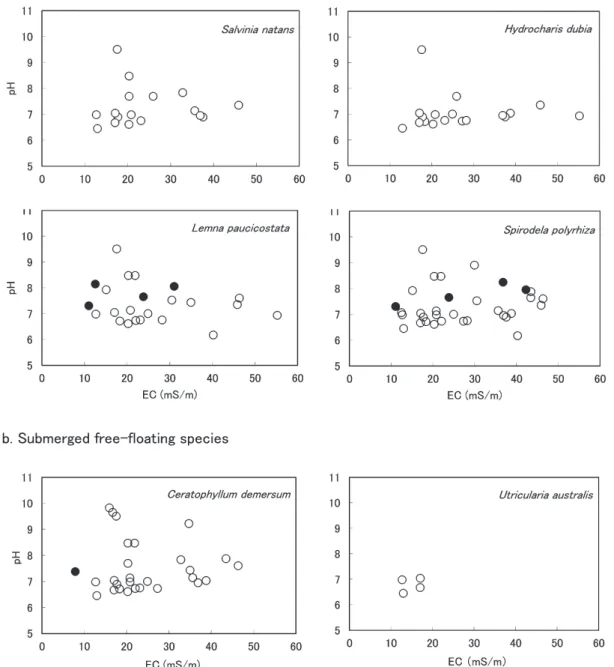
Aquatic plant distribution and water quality True aquatic plants (free-floating, floating- leaved and submerged plants) complete their life cycle in the water. They are expected to depend more directly on water quality than emergent plants which generally grow along the edges of the water and also grow occasion- ally in terrestrial habitats. Therefore, we show the relationship between water quality (EC and pH) and distribution of true aquatic plants, ex- cept for emergent plants. Figures 4-6 show the distribution of the plants found in more than two sites by their life forms. Cultivated Nym- phaea sp. was excluded from Fig. 5. Trapa spp.
(Fig. 5) and Najas spp. (Fig. 6) include the species found in less than three sites. The spe- cies found in the sites where water quality was measured at more than one point have more measured values than their site numbers. For example, Salvinia natans occurred at 13 sites
(Table 1) but its measured values are 17 (Fig.
4), because water quality was measured at more than one point at two sites (12, 28). The species found in the sites without enough water to measure water quality have less measured values than their site numbers (e.g. Nymphoi- des indica in Fig. 5 occurred at four sites on the island, but one of the sites was dried up).
Many taxa occurred in water with a wide range of EC. However Utricularia australis (Fig.
4), Potamogeton natans, P. cristatus Regel et
Maack and Nymphoides indica (Fig. 5) were restricted to the water with lower EC, mostly below 30 mS/m. Among the species found in less than three sites, Trapa natans var. japon- ica Nakai, Ottelia alismoides (L.) Pers., Pota- mogeton pusillus L., Najas graminea Del. and N.
japonica Nakai were distributed in the water with EC < 30 mS/m.
The majority of the taxa were distributed in the water with pH 6-10. However Potamogeton natans, P. distinctus A. Benn., P. cristatus (Fig.
5), Chara braunii and Myriophyllum sp. (Fig. 6) were not distributed in the water with pH < 7.
Utricularia australis (Fig. 4) and P. natans (Fig.
5) showed narrow distribution of pH values.
Utricularia australis (Fig. 4) was restricted to lower values of EC and pH. No plant was re- stricted to very high values of EC and pH.
Discussion
Characteristics of water quality and aquatic flora of study sites
Toivonen and Huttunen (1995) stated that EC is a good overall parameter of the general nutrient status, and that EC has a high cor- relation with total nitrogen and phosphorus.
In the studies of Japanese irrigation ponds, a correlation between EC and nutrient concentra- tions was reported (e.g. Kasuya et al. 1989;
Kunii 1991; Kagawa et al. 2008). In three studies on water quality of Japanese ponds
(Kasuya et al. 1989; Kunii 1991; Naka 2001), the average, minimum and maximum values of EC were 9.1-11 mS/m, 1.5 mS/m (Kunii 1991)
Eleocharis acicularis var. longiseta マツバイ 2 2
Eleocharis sp. 1 ハリイ属 sp. 1 1 1
Eleocharis sp. 2 ハリイ属 sp. 2 1 1
Schoenoplectus mucronatus subsp.
robustus カンガレイ 10 10
Schoenoplectus validus フトイ 2 4 6
Polygonum amphibium エゾノミズタデ EN 1 1
Nelumbo nucifera ハス 7 1 8
Ludwigia ovalis ミズユキノシタ 5 5
Elatine triandra ミゾハコベ 2 2
Limnophila sessiliflora キクモ 1 1
Number of species 47 41 64
1)Endangered species category (Ministry of Environment, Republic of Korea 2006).
2)Rare plant category (Korea National Arboretum 2008)
3)Red List species category of Ministry of the Environmen (Ministry of the Environment, Government of Japan 2012)
4)EN: Endangered, VU: Vulnerable, NT: Near threatened, LC: Least concern, DD: Data deficient.
Table 1. Continued
and 33.6 mS/m (Naka 2001) respectively. In the studies of the ponds in western Japan by the first author, most of the EC values were less than 20 mS/m (Shimoda 1993, 1997, 2005a; Shimoda and Ideguchi 1993). However in an area dominated by citrus orchards, the EC values of pond water were 12.2-41.6 mS/m and its average value was 24.5mS/m (Kagawa
et al. 2008). The values of total nitrogen (TN) and total phosphorus (TP) of the ponds in this area were extremely higher than the values of the areas without orchard (Kasuya et al. 1989;
Shimoda and Hashimoto 1993; Naka 2001). In our study area in Korea, the average, min- imum and maximum values of EC were 24.7 mS/m, 7.9 mS/m and 55.2 mS/m respectively.
Fig. 4. Relationship between the distribution of free-floating species, EC and pH. ○: Korean Peninsula, ●: Jeju Island.
Fig. 5. Relationship between the distribution of floating-leaved species, EC and pH. Open mark: Korean Penin- sula, filled mark: Jeju Island. Trapa spp. includes T. japonica (○, ●) and T. natans var. japonica (△).
Many sites showed high EC > 20 mS/m (Fig.
2), and the range of EC values was similar to the value range of the area dominated by citrus orchard (Kagawa et al. 2008). Most of the sites in our study had watersheds which were occu- pied partly or completely by agricultural land use such as rice fields, upland fields and or- chards. Therefore high EC values suggest that our Korean study sites included many nutrient- rich ponds and reservoirs.
Most of the confirmed taxa in the present study are distributed in Japan. The abundant true aquatic species found in more than 10
sites in Table 1 (e.g. Trapa japonica) very commonly dominate in Japanese nutrient-rich ponds (Shimoda and Hashimoto 1993; Kadono 1994; Naka 2001; Hamashima 2008; Shimoda and Kagawa 2009). Spirodela polyrhiza, Trapa japonica and Euryale ferox were reported to have wide growth range and are found even in the ponds with high EC > 30mS/m in Japan
(Naka 2001; Mineta and Hidaka 2002). Among the species in Table 1, Utricularia australis, Potamogeton pusillus and Najas graminea were restricted to nutrient-poor ponds in Japanese studies (Shimoda and Hashimoto 1993; Naka Fig. 6. Relationship between the distribution of submerged species, EC and pH. Open mark: Korean Peninsula,
filled mark: Jeju Island. Najas spp. includes Najas sp. (○, ●), N. graminea (▲) and N. japonica (■).
2001; Shimoda and Kagawa 2009). In our study, these three species were rare and oc- curred in the sites with EC < 20 mS/m (Figs. 4, 6).
Brasenia schreberi J. F. Gmel, Nymphaea tetragona Georgi and Potamogeton fryeri A.
Benn. are known to be characteristic species in weak-acidic and nutrient-poor water (Shimoda and Hashimoto 1993; Naka 2001; Hamashima 2008). Although these three species are dis- tributed in Korea, they were not found in our study sites. Kim (1996) reported that optimal condition for the growth of B. schreberi in Ko- rea was near neutral pH, low conductivity and low turbidity. Among the study sites of Kim
(1996), B. schreberi was distributed in the wa- ter with pH 6.4-7.0 and EC with 6.6-13.9 mS/m.
This result is similar to the results of studies in Japan (Shimoda 1997, 2005a; Naka 2001). In our study sites, waters with near neutral pH and low EC <10 mS/cm were very limited (Fig.
2). Compared with Japanese aquatic flora, our study area was characterized by the species of wide distribution and/or eutrophic water.
In Japanese irrigation ponds, alien aquatic plants such as Egeria densa Planch., Elodea nuttallii (planch.) St. John and Eichhornia crassipes (Mart.) Solms-Laub. occur and flour- ish in many places, particularly in eutrophic waters (Kadono 1994). In the present study, we did not find any alien species except Nym- phaea sp., which was obviously planted for an ornamental purpose.
Threatened aquatic species of Korea and Japan
The aquatic flora of study sites (Table 1)
includes seven species regarded as threatened in Korea. It also includes 15 Japanese threat- ened species. Four species among them are threatened in both countries. The remaining 11 Japanese Red List species are common in Ko- rea. The Japanese threatened species in Table 1 include the following nine species which are known as rice field weeds (Kasahara 1951;
Kadono 1994): Ricciocarpos natans, Salvinia natans, Hydrocharis dubia, Utricularia austra- lis, Chara braunii, Ottelia alismoides, Najas ja- ponica, Marsilea quadrifolia L. and Monochoria
korsakowii Regel et Maack. Most of them were also regarded as rice field weeds in Korea (Nakai 1914; Chung 1956). We investigated aquatic flora in Gyeongsangbuk-do Province, southeast- ern Korea in 1989, and found S. natans and M.
quadrifolia in five irrigation ponds (Shimoda 1990). Many aquatic species of nutrient-rich water, which are threatened in Japan now, are still distributed widely in Korean rural areas.
Brasenia schreberi is regarded as threatened in Korea. Its endangered species category is II
(Ministry of Environment, Republic of Korea 2006) and rare plant category is VU (Korea National Arboretum 2008). The species was not found in the study sites. The species is common in unpolluted ponds and lakes (Kadono 1994), and not regarded as threatened in Japan. It suggests that ponds, reservoirs and lakes, which are suitable for the characteristic species of nutrient-poor water, are not common in the rural areas in southern Korea.
The diversity of Japanese aquatic plants has been reduced by filling, structural modification and water pollution (Kadono 1994). Yamasaki and Hayashi (2004) showed the possibility of the effect of herbicides on the disappearance of Euryale ferox. Therefore wide-spread of herbi- cides in Japan is thought to affect the decline of Japanese aquatic plants. Many sites of this study are regarded to be nutrient-rich, like the ponds surrounded by citrus orchards in Japan
(Shimoda and Kagawa 2009). However Ko- rean nutrient-rich ponds are still the habitats of many Japanese Red List species. There is a possibility that differences in use and manage- ment of irrigation ponds and use of herbicides in both countries resulted in the differences of aquatic flora of both countries.
Conclusions
The most species-rich site was Junam reser- voir (site 29: 285 ha), which had the largest area among the study sites. However, small ponds were also the habitats of diverse aquatic plants. Many of the confirmed species showed wide distribution with water quality. A few spe- cies such as Utricularia australis (Fig. 4) and Nymphoides indica (Fig. 5) were found only in water with low EC values. Therefore nutrient-
poor ponds with low EC are particularly valu- able as the habitats of diverse aquatic plants.
There is a big possibility that pond filling, water pollution, structural modification and pond abandonment will produce negative effects on aquatic plants, as in Japanese rural areas
(Shimoda 2005b). On Jeju Island, we saw sev- eral abandoned small ponds without water. Our study shows that ponds of Korean rural areas support diverse aquatic flora including rare and threatened species. Therefore, detailed and ur- gent surveys on aquatic plants of rural areas are required, especially on small water bodies.
Acknowledgments
We would like to acknowledge the assistance of Heon-Kyu Kim and Ryosuke Hara during the field research. We would also like to thank John B. Laing for the revision of English.
References
Choi, H. K. and Lee, S.-M. 1987. Flora and standing stock of vascular hydrophytes in the Chunam Chŏsuji. Korean. J. Environ. Biol. 5:
39-50. (in Korean with English abstract) Chung, T.-H. 1956. Korean Flora Vol. 2. Sin-
jisa, Seoul. (in Korean)
Chung, Y. H. and Choi, H. K. 1981. Flora and distribution of vascular hydrophytes from the Han River. Jour. Kor. Pl. Tax. 11: 43-52. (in Korean with English abstract)
Chung, Y. H. and Choi, H. K. 1983. Flora and distribution of vascular hygro- and hydro- phytes from the estuary of Nagdong River.
Korean J. Bot. 26: 197-206. (in Korean with English abstract)
Chung, Y. H. and Choi, H. K. 1985. Flora and standing stock of vascular hydrophytes from the water course of Naktong River. Korean J.
Environ. Biol. 3: 29-44. (in Korean with Eng- lish abstract)
Chung, Y. H. and Choi, H. K. 1987. Flora of vascular hydrophytes in natural swamp in Haman county. Korean J. Environ. Biol. 5:
17-28. (in Korean with English abstract) Chung, Y. H., Shin, H. and Lee, S. M. 1989.
Flora and standing crop of vascular hydro- phytes in the estuary of Nakdong River. Nat.
Conserv. 65: 39-48. (in Korean with English
summary)
Hamashima, S. 1983. Correlation of the flora of aquatic macrophytes with the chemical contents of water in the irrigation reservoirs of Tokai District. Jpn. J. Limnol. 44: 1-5. (in Japanese with English abstract)
Hamashima, S. 2008. Distribution of aquatic macrophytes and water chemistry in the ir- rigation reservoirs and ditches of Tokai Dis- trict. J. Phyogeogr. Taxon. 56: 63-71. (in Japanese)
Izumi, S. 1966. Che Ju Do (Quelpart) island- ers. University of Tokyo Press, Tokyo. (in Japanese with English summary)
Japan Society for Analytical Chemistry, Hok- kaido. 1981. Analysis of water (3rd ed.)*. Kagaku Dôjin, Kyoto. (in Japanese)
Ji, K.-J. 2008. Characteristics of hydrophytes distribution in agricultural wetlands in Ko- rea. KCID J. 15: 62-76. (in Korean with English abstract)
Kadono, Y. 1984. Aquatic macrophytes of the irrigation reservoirs in East Harima Prov- ince, Hyogo Prefecture, southwestern Japan. J.
Phyogeogr. Taxon. 32: 127-135. (in Japanese with English summary)
Kadono, Y. 1987. Aquatic plant communities of irrigation reservoirs in East Harima Area, Hyôgo Pref., southwestern Japan. J. Phyo- geogr. Taxon. 35: 42-47.
Kadono, Y. 1994. Aquatic plants of Japan. Bun- ichi Sogo Shuppan, Tokyo. (in Japanese) Kagawa, H., Shikata, M., Kida, M. and Shi-
moda, M. 2008. Effects of water quality on the richness of aquatic plants in irrigation ponds in an agricultural area containing many citrus orchards. Jpn. J. Limnol. 69:
1-23. (in Japanese with English abstract) Kang, M.-j., Kim, C.-S. and Oh, K.-h. 2007.
Flora, actual vegetation map, and primary production of the vascular hydrophytes and hygrophytes in the Upo wetland. J. Kor. Wet- land Soc. 9: 45-55. (in Korean with English abstract)
Kasahara, Y. 1951. Studies on Japanese weed species and their geographic distribution 4.
Geographic distribution and emergence pat- terns of rice field weeds*. Nogaku Kenkyu 39: 143-154. (in Japanese)
Kasuya, M., Kato, T., Hamada, R., Nagata, K., Kino, K. and Toyota, I. 1989. Water quality analysis of irrigation reservoirs in eastern Owari area using principal component analy- sis and cluster analysis. Res. Bull. Aichi Ag- ric. Res. Ctr. 21: 123-130. (in Japanese with English summary)
Kim, J.-W., Lee, H.-K., Kim, M.-K. and Cho, I. S. 1991. Flora and distribution of vas- cular hydrophytes in Choonsan Reservoir, Kyŏngsangnam-Do, Korea. J. Env. Stud., Inst.
Env. Stud., Pusan Natl. Univ. 9: 43-50. (in Korean with English abstract)
Kim, Y.-D. 1996. Characterization of water and sediment environment in water shield (Brase- nia schreberi) habitats. Korean J. Ecol. 19:
209-216. (in Korean with English abstract) Kolbek, J. and Dostálek, J. 1996. Vegetation
of water basins in the northern part of the Korean Peninsula. Thaiszia – J. Bot. 5: 121- 130.
Korea Meteorological Administration. 2011. Cli- matological normals of Korea. Korea Meteoro- logical Administration, Seoul.
Korea National Arboretum. 2008. Rare plant data book in Korea. Korea National Arbore- tum, Pocheon. (in Korean)
Kunii, H. 1991. Aquatic macrophyte composi- tion in relation to environmental factors of ir- rigation ponds around Lake Shinji, Shimane, Japan. Vegetatio 97: 137-148.
Lee, Y. N., Lee, N. S. and Yeau, S. H. 1987. The flora in the lower area of Naktong River. Bull.
KACN 9: 121-141. (in Korean with English abstract)
Lim,Y., Ma, S.-M., Na, S.-T., Choi, H.-K. and Shin, H. 2005. Flora and ecological charac- teristics of hydrophytes in the littoral zone of Paldang Reservoir. Korean J. Limnol. 38: 30- 44. (in Korean with English abstract) Mineta, T. and Hidaka, K. 2002. Classifica-
tion of irrigation ponds in Nakatado Region, Kagawa Prefecture, from the viewpoint of aquatic macrophyte flora. Bull. Water Plant Soc., Japan 74: 35-44. (in Japanese with English abstract)
Ministry of Environment, Republic of Korea.
2006. Green Korea 2006. Ministry of Environ- ment, Republic of Korea, Gyeonggi.
Ministry of the Environment, Government of Japan. 2008. The Third National Biodiversity Strategy of Japan. Ministry of the Environ- ment, Government of Japan, Tokyo.
Ministry of the Environment, Government of Japan. 2012. Threatened Species Information*. http://www.biodic.go.jp/rdb/rdb_f.html. (in Japanese)
Na, H. R., Shin, H. and Choi, H.-K. 2008a.
An unrecorded species from Korean Flora:
Vallisneria spinulosa (Hydrocharitaceae). Ko- rean J. Pl. Taxon. 38: 69-77. (in Korean with English abstract)
Na, S. T., Choi, H.-K., Kim, Y. D. and Shin, H.
2008b. Taxonomic identities and distribution of Utricularia japonica and U. tenuicaulis in Korea. Korean J. Pl. Taxon. 38: 111-120. (in Korean with English abstract)
Naka, M. 2001. Aquatic plants of irrigation ponds in Matsusaka City, Mie Prefecture.
Bull. Water Plant Soc., Japan 72: 5-16. (in Japanese)
Nakai, T. 1914. The survey report on plants of Jeju Island and Wan Island*. Government General of Chosen, Keijo (Seoul). (in Japa- nese)
Ramsar Convention on Wetlands. 2008. Strate- gic Framework and guidelines for the future development of the List of Wetlands of In- ternational Importance of the Convention on Wetlands (Ramsar, Iran, 1971), Ramsar Con- vention on Wetlands, Gland.
Sculthorpe, C. D. 1967. The biology of aquatic plants. Edward Arnold Ltd, London (rpt.
1985. Koelts Scientific Books, Königstein). Seddon, B. 1972. Aquatic macrophytes as lim-
nological indicators. Freshwat. Biol. 2: 107- 130.
Shimoda, M. 1983. Aquatic plants of ponds in and around the new campus of Hiroshima University. J. Phyogeogr. Taxon. 31: 46-57. (in Japanese with English summary)
Shimoda, M. 1985. Phytosociological studies on the vegetation of irrigation ponds in the Saijo Basin, Hiroshima Prefecture, Japan. J. Sci.
Hiroshima Univ., Ser. B, Div. 2 19: 237-297.
Shimoda, M. 1986. The vegetation of irrigation ponds in the Oasa basin, Hiroshima Prefec- ture, western Japan. Hikobia 9: 457-465.
Shimoda, M. 1990. A trip in Gyeongsangbuk- do, Korea*. Bull. Water Plant Soc., Japan 39:
2-7. (in Japanese)
Shimoda, M. 1993. Habitats of the genus Nuphar Sm. in the Saijo Basin, Hiroshima Prefecture, western Japan. J. Phytogeogr.
Taxon. 41:107-111.
Shimoda, M. 1997. Differences among aquatic plant communities in irrigation ponds with differing environments. Jpn. J. Limnol. 58:
157-172.
Shimoda, M. 2005a. Aquatic plants of irriga- tion ponds*. Committee for Compilation of History of Kurose Town, Kurose, Hiroshima Prefecture. (in Japanese)
Shimoda, M. 2005b. Emerged shore vegetation of irrigation ponds in western Japan. Phyto- coenologia 35: 305-325.
Shimoda, M. and Hashimoto, T. 1993. Water plant distribution and water quality of irriga- tion ponds. Bull. Water Plant Soc., Japan 49:
12-15. (in Japanese)
Shimoda, M. and Ideguchi, K. 1993. Aquatic plants of irrigation ponds in eastern part of Shimonoseki City, Yamaguchi Prefecture.
Bull. Water Plant Soc., Japan 51: 7-11. (in Japanese)
Shimoda, M. and Kagawa, H. 2009. Aquatic plant distribution of irrigation ponds in re- lation to land use and water quality in an agricultural landscape dominated by citrus orchards in Hojo area, Shikoku Island, south- western Japan. Veg. Sci. 26: 65-78
Takano, F. 1996. Jeju Island, Korea*. Chuo- koron-sha, Tokyo. (in Japanese)
Toivonen, H. and Huttunen, P. 1995. Aquatic macrophytes and ecological gradients in 57 small lakes in southern Finland. Aquat. Bot.
51: 197-221.
Yamasaki, S. and Hayashi, K. 2004. Effect of herbicide on growth of Euryale ferox Salisb.
Bull. Water Plant Soc., Japan 80: 1-5. (in Japanese)
* The titles of books and papers were trans- lated from the original Japanese titles by the present authors.
下田路子1・宋 鍾碩2:韓国南部の農村地帯の水草 相、および水草相と土地利用・水質との関係
韓国の農村地帯の水草相と水草の生育環境を把 握することを目的に、朝鮮半島南部32か所と済州 島16か所、計48か所において植物と水質の調査を 行った。朝鮮半島の調査地は水田灌漑用のため池で あり、済州島の調査地は家畜の飲料用と灌漑や洗い 物用の池である。調査地のうち、農地に囲まれた池 は、電気伝導度(EC)が40mS/m以上の高い値を 示した。両地域で浮遊植物8種、浮葉植物9種、沈 水植物14種を確認した。このうちヒシなど11種は 朝鮮半島と済州島に共通であったが、オニバスなど 13種は朝鮮半島、オヒルムシロなど7種は済州島の みに分布し、両地域の植物相に違いがあった。広範 囲のEC値に分布する種が多かったが、ガガブタな どの数種はECが30mS/m以下の水域に分布が限ら れていた。ヒシなどの確認地点が多い種は、日本の 富栄養な水域に繁茂する水草であった。調査地の水 草相は、生育範囲の広い種と富栄養な水域の種で特 徴づけられた。確認種には7種の韓国の絶滅危惧種 が含まれていた。また15種の日本の絶滅危惧種も 含まれ、そのうちの9種が水田雑草であった。今回 の調査結果は、韓国の農村地帯のため池が、稀少種 や絶滅危惧種を含む多様な水草の生育地として貴重 な存在であることを示している。
(1〒417-0801 富 士 市 大 淵325 常 葉 大 学 社 会 環 境 学 部;2〒760-749 韓 国 慶 北 安 東 市 松 川 洞 388 安東大学校自然科学大学生命科学科)
Site No.1)Latitude (N) Longitude (E) Type2) Main land use of surrounding area EC (mS/m)3)pH
1 35º 51' 09.9" 128º 50' 59.5" Pond Forest, grassland, orchard 34.9 7.44
2 a 35º 51' 03.4" 128º 51' 55.1" Pond Forest, grassland, orchard 16.7 9.66
2 b 35º 51' 00.0" 128º 51' 49.5" Pond Forest, orchard 15.9 9.83
3 35º 50' 15.1" 128º 49' 20.5" Pond Forest, orchard 20.3 7.70
4 a 35º 50' 06.5" 128º 49' 12.2" Pond Forest, grassland, paved road 27.7 9.82
4 b 35º 50' 08.3" 128º 49' 15.8" Pond Forest, grassland 43.4 7.65
5 35º 49' 24.7" 128º 48' 52.6" Pond Forest, grassland, orchard, paved road, factory 30.5 7.53 6 35º 49' 23.2" 128º 47' 20.6" Pond Forest, orchard, upland fields 55.2 6.94 7 35º 49' 01.8" 128º 47' 02.7" Pond Forest, grassland, upland fields 45.8 7.36
8 a 35º 48' 40.6" 128º 47' 03.7" Reservoir Paved road 38.7 7.04
8 b 35º 48' 46.4" 128º 46' 55.8" Reservoir Forest, orchard 43.4 7.88
9 a 35º 36' 17.3" 128º 28' 18.9" Pond Forest, grassland 18.3 6.72
9 b 35º 36' 13.6" 128º 28' 24.8" Pond Forest, grassland, houses 27.2 6.74
10 a 35º 35' 17.5" 128º 28' 33.0" Pond Forest, rice fields 22.0 6.74
10 b 35º 35' 18.5" 128º 28' 21.5" Pond Forest, grassland, rice fields 20.7 7.14 11 a 35º 34' 49.9" 128º 28' 30.5" Pond Forest, rice fields, upland fields, houses 40.2 6.18
11 b 35º 34' 51.6" 128º 28' 22.8" Pond Forest, rice fields 30.2 7.81
12 a 35º 32' 57.0" 128º 25' 14.2" Reservoir Forest, embankment 37.5 6.90
12 b 35º 32' 54.8" 128º 25' 08.5" Reservoir Forest, grassland 35.6 7.15
12 c 35º 32' 56.7" 128º 24' 59.4" Reservoir Forest 36.9 6.96
13 35º 31' 17.5" 128º 23' 12.7" Pond Forest, rice fields, upland fields 20.2 6.62
14 35º 31' 08.1" 128º 24' 08.5" Reservoir Forest, rice fields 23.1 6.76
15 35º 31' 31.3" 128º 26' 22.0" Reservoir Forest, grassland, rice fields, factory 32.8 7.84 16 35º 24' 43.5" 128º 31' 26.9" Pond Grassland, rice fields, paved road 25.9 7.70
17 35º 26' 16.3" 128º 31' 48.4" Pond Rice fields, paved road 29.9 8.91
18 35º 25' 30.8" 128º 32' 51.1" Pond Forest, grassland, upland fields 15.9 8.54 19 35º 25' 12.6" 128º 32' 50.2" Pond Forest, grassland, upland fields 7.9 9.03 20 35º 24' 57.3" 128º 32' 46.7" Pond Forest, orchard, upland fields 10.2 9.54
21 35º 24' 00.0" 128º 32' 52.0" Pond Forest, upland fields 34.7 9.23
22 35º 23' 48.6" 128º 32' 19.9" Ditch Rice fields, abandoned rice fields 46.3 7.61
23 35º 20' 24.7" 128º 20' 03.7" Reservoir Forest, rice fields 17.7 6.9
24 35º 19' 05.5" 128º 21' 01.1" Pond Forest, rice fields 17.0 7.05
25 35º 18' 30.6" 128º 22' 50.8" Pond Forest, rice fields 12.6 6.99
26 35º 18' 10.9" 128º 25' 08.8" Reservoir Forest, rice fields, paved road 15.1 7.93
27 35º 20' 47.2" 128º 39' 45.9" Reservoir Rice fields 17.5 9.51
28 a 35º 20' 29.5" 128º 40' 14.3" Reservoir Rice fields 12.4 7.07
28 b 35º 19' 53.9" 128º 40' 21.9" Reservoir Paved road 20.3 8.48
29 a 35º 18' 29.5" 128º 40' 38.8" Reservoir Forest, embankment 20.8 6.99
29 b 35º 18' 31.8" 128º 40' 41.4" Reservoir Forest, embankment 17.0 6.68
29 c 35º 18' 39.6" 128º 40' 48.4" Reservoir Embankment 12.9 6.46
29 d 35º 19' 32.9" 128º 40' 26.9" Reservoir Houses, paved road 21.8 8.48
30 35º 18' 01.2" 128º 40' 14.7" Pond Forest, grassland, paved road 28.2 6.76
31 35º 17' 59.3" 128º 40' 12.8" Pond Grassland, paved road 24.9 7.01
32 a 35º 18' 35.3" 128º 38' 51.9" Pond Forest, orchard 15.8 9.26
32 b 35º 18' 32.7" 128º 38' 49.5" Pond Orchard 16.9 8.86
1)Number in Fig. 1.
2)Pond is below 8 ha, and reservoir is over 8 ha (Ramsar Convention on Wetland 2008).
3)Calibrated at 25°C.
Appendix 1. Locations and brief environmental information of study sites in Korean Peninsula
Site No.1)Latitude (N) Longitude (E) Type2) Main land use of surrounding area EC (mS/m)3) pH 33 a 33º 27' 16.1" 126º 20' 49.0" Pond Grassland, upland fields, paved road 42.2 7.96 33 b 33º 27' 19.7" 126º 20' 52.5" Pond Upland fields, paved road 36.8 8.25
34 33º 28' 14.6" 126º 23' 07.9" Reservoir Forest, paved road 13.4 10.07
35 33º 28' 14.2" 126º 25' 34.3" Pond Grassland 12.7 9.88
36 33º 30' 19.9" 126º 38' 00.6" Pond Upland fields, houses, paved road 19.3 7.83
37 33º 31' 11.8" 126º 39' 51.6" Pond Orchard, lawn, house 12.5 8.15
38 33º 31' 23.5" 126º 40' 05.4" Pond Forest, upland fields 19.4 7.62
39 33º 30' 30.5" 126º 43' 01.6" Pond Forest, grassland, paved road 7.9 7.39
40 33º 30' 12.2" 126º 44' 23.7" Pond Forest, paved road na4) na
41 33º 28' 10.6" 126º 36' 22.8" Pond Forest, paved road 12.6 10.44
42 33º 28' 10.6" 126º 36' 22.8" Pond Forest 11.0 7.31
43 33º 27' 58.4" 126º 36' 17.3" Pond Forest, grassland 25.7 7.91
44 33º 28' 03.1" 126º 38' 52.1" Pond Forest, grassland 19.6 8.21
45 33º 28' 28.0" 126º 39' 30.9" Pond Forest, grassland, upland fields na na
46 33º 15' 30.5" 126º 16' 43.4" Pond Forest, upland fields 31.0 8.06
47 33º 13' 27.2" 126º 17' 40.7" Pond Forest, grassland, upland fields 36.8 10.52
48 33º 15' 08.6" 126º 32' 34.9" Ditch Rice fields 23.8 7.66
1)Number in Fig. 1.
2)Pond is below 8 ha, and reservoir is over 8 ha (Ramsar Convention on Wetland 2008).
3)Calibrated at 25°C.
4)Not analyzed.
Appendix 2. Locations and brief environmental information of study sites on Jeju Island