The Development of
Agricultural-Based Small Urban Areas to
Promote Rural Development
A Case of the Cattle-Related Industries in
Ampel Sub-District, Central Java
A thesis submitted in fulfillment of the requirements for the
award of the degree
Doctor of Philosophy
from
Ritsumeikan Asia Pacific University
Graduate School of Asia Pacific Studies
Beppu, Japan
by
Emil Elestianto Dardak
CERTIFICATION
I, Emil Elestianto Dardak, declare that this thesis, submitted in fulfillment of the requirements for the award of Doctor of Philosophy, in the Graduate School of Asia Pacific Studies, Ritsumeikan Asia Pacific University, is wholly my own original work unless otherwise referenced or acknowledged. The document has not been submitted for qualifications at other academic institutions.
Emil Elestianto Dardak 15 May 2007
TABLE OF CONTENTS
LIST OF TABLES... i
LIST OF FIGURES... iv
ACKNOWLEDGEMENTS ... vi
EXECUTIVE SUMMARY ...viii
CHAPTER I INTRODUCTION ... 1
1.1. Background...1
1.2 The Challenges Faced in Agropolitan Development ...8
1.3 Research Objective ...10
1.4 Scope of Research...11
1.5 Significance of Research...11
CHAPTER 2 THEORETICAL FRAMEWORK ... 13
2.1. Introduction...13
2.2. The Early Location Theories ...14
2.2.1 von Thunen and Weber...15
2.2.2 Christaller and Losch ...20
2.3 Major Works on Spatial Economics in the 1950s and 1960s - The Classical Location Theories ...24
2.3.1 Empirical Regularities in Space-Economy ...24
2.3.2 Transportation Input and Agglomeration Economies...26
2.3.3 Agricultural Location Theory ...31
2.3.4 Urban Location Model...34
2.4 Major Works on Spatial Economics after the Classical Location Theories: Modern Regional Economics...37
2.4.1 Fujita’s Model of Urban Economics and Agglomeration...37
2.4.2 The Henderson Study on Urban Systems ...38
2.4.3 Spatial Version of Dixit-Stiglitz Monopolistic Competition Model...41
2.5. The Economic Base Model and the Multiplier ...45
2.6. The Concept of Accessibility...49
CHAPTER 3 LITERATURE REVIEW OF EMPIRICAL
STUDIES ... 53
3.1. Introduction...53
3.2. Regional Economic Development ...55
3.3. The Social Benefits of Establishing Small Urban Centers ...60
3.3.1. Market Linkage and Employment Creation through Market-Based Small Urban Center Development: Growth Poles as Service Provision Centers ...60
3.3.2. Do Small Urban Centers Cannibalize Larger Urban Centers? ...64
3.3.3. The Social Economy in Rural Areas...65
3.4. Challenges and Possible Drawbacks of Small Urban Centers...66
3.4.1. Policy Challenges...66
3.4.3. Equitable Participation of Rural Population in Urban Development...68
3.5. Pre-Conditions for the Effective Functioning of Small Urban Centers...71
3.5.1 Exogenous Factors...71
3.5.1.1. National Economic Policy...71
3.5.1.2. Relationship with Larger Urban Centers...73
3.5.2 Endogenous Factors...75
3.5.2.1 Rural-Urban Linkage Pattern ...75
3.5.2.2. Rural-Urban Migration...77
3.5.2.3. Expectations of Available Services in Rural Towns...83
3.5.2.4 Socio-economic Factors Affecting the Utilization of Small Rural Town Services: Commuting Issues ...86
3.6 Prospects Ahead & Strategies for the Development of Rural Towns...91
3.6.1 Off-Farm Employment...91
3.6.2 Participating in the Service Industry...93
3.6.3 A Success Story from Thailand ...95
3.7. Summary ...96
CHAPTER 4 THE CONCEPTUAL FRAMEWORK OF
AGROPOLITAN DEVELOPMENT... 98
4.1. The Definition of Agropolitan Development...98
4.2. The Objective of Agropolitan Development...102
4.3. The Criteria of Agropolitan Development...103
4.4. The Components of Agropolitan Development...104
CHAPTER 5
RESEARCH METHODOLOGY... 108
5.1 Introduction...108
5.2 Investigating the Role of Accessibility in Urban Growth...108
5.2.1 Theoretical Background...108
5.2.2 Methodology for Investigating Accessibility...112
5.3 Analysis of the Spatial Pattern of Industrial Linkages...113
5.3.1 Theoretical Background...113
5.3.2 Indices for Industrial Linkage Analysis...115
5.4 The Relationship between the Socio-Economic Factors and the Individual’s Level of Use of the Rural Town ...123
5.4.1 Theoretical Background...123
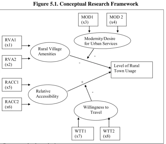
5.4.2 Structural Equation Modeling...125
5.4.3 Variable Definition ...127
5.4.3.1 Accessibility ...128
5.4.3.2 Rural Village Amenities...129
5.4.3.3 Willingness to Travel ...130
5.4.3.4 Desire to Consume Urban Services (Level of Modernity)...131
5.4.4 The Path Diagram and Causal Relationship ...133
5.4.5. Hypotheses...135
CHAPTER 6 RESEARCH AREA ... 145
6.1 Introduction...145
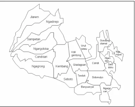
6.2 Ampel Sub-District ...148
6.3 Ampel City Development Plan ...151
6.4 Socio-economic Background of Ampel...152
6.5 The Cattle-Related Sector in Ampel ...156
6.6 Ampel as an Agropolitan Region...166
CHAPTER 7 ANALYSIS... 171
7.1. Introduction...171
7.2. Investigating the Role of Accessibility in Urban Growth...171
7.2.1. Geographic and Potential Accessibility Measures...173
7.2.2. Investigating the Indicators of Economic Activities for the Most Accessible Villages ...182
7.2.3 Analysis of Geographical Conditions and Road Network...189
7.2.4 Analyzing the Relationship between Distance from Growth Center and Village Level Growth ...192
7.2.5 Summary ...195
7.3. Analysis of the Spatial Pattern of Industrial Linkages...196
7.3.1. Classification of Cattle-Related Economic Sectors ...196
7.3.2. The Forage Grass Growing Industry and the Forage Grass Market ...208
7.3.3. Milk Cattle and Milk Cooperative Forward Linkages...218
7.3.4. Meat Cattle and Slaughter House Forward Linkages ...221
7.3.5 The Animal Market...223
7.3.6 Meat Processing and Dendeng and Floss Marketing Forward Linkages...224
7.3.7. Ampel Market Forward Linkages...225
7.3.8. Comparison with Rural Urban Linkages in West Java...227
7.3.9. Summary ...236
7.4. The Relationship between the Socio-Economic Factors and the Residents’ Level of Use of the Rural Town ...237
7.4.1 Introduction...237
7.4.2 Analysis and Results...237
CHAPTER 8 CONCLUSIONS ... 248
8.1 Summary ...248
8.1.1 Theoretical Discussion...248
8.1.2 Findings from Recent Studies...253
8.1.3 The Analysis of Accessibility ...258
8.1.4 The Analysis of Relationship between the Socio-Economic Factors and the Level of Rural Town Usage...264
REFERENCES...271 APPENDICES Appendix 1...283 Appendix 2...285 Appendix 3...286 Appendix 4...287 Appendix 5...289 Appendix 6...300 Appendix 7...306
LIST OF TABLES
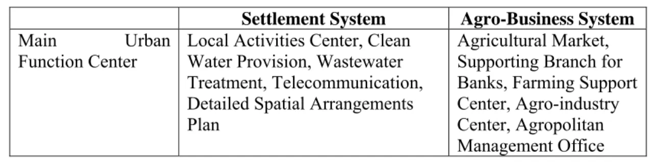
Table 4.1. Systems in Agropolitan Region 106 Tabel 6.1 Total Population and Population Density in Ampel Sub-District 149 Table 6.2. Educational Facilities in Ampel 153 Table 6.3. Banking Facilities in Ampel 155 Table 6.4..Commercial Facilities in Ampel 155
Table 6.5. Average Weekly Per Capita Consumption of some Main Food in Ampel in 2003 156
Table 6.6 Estimated Consumption of Main Food Items in 2005 157 Table 6.7. Total Staple Food Production, 2005 158 Tabel 6.8. Balance of Staple Food Production and Demand, 2005 159 Table 6.9.Harvest Area, Average Production and Production of Corn in Ampel 160 Table 6.10. Estimated Consumption of Animal Farm Products in 2005 160 Table 6.11. Total Production of Animal Farms in 2005 161 Table 6.12. Population of Livestock, 2004 162 Table 6.13. Estimated Edible Animal Farm Production, 2005 162 Table 6.14. Balance of Animal Farm Production and Demand in 2005 162 Table 6.15. Estimated Non-Edible Animal Farm Products, 2005 163 Table 6.16. Livestock Production 164 Table 6.17. Meat Production, 2004 165 Table 6.18. Milk Production, 2004 165 Table 6.19. Analysis of Carrying Capacity for Ampel 167 Table 6.20. Types of Growth Centers 169
Table 6.21. Selection of the Growth Center for Agropolitan 169 Table 7.1. Statistics of Ampel Sub-District 172 Table 7.2. Distance between Villages in Ampel Sub-District 175 Table 7.3. Geographic Accessibility Matrix 176 Table 7.4. Potential Accessibility Matrix based on Working Age Population 178 Table 7.5. Potential Accessibility Matrix based on Livestock 179 Table 7.6. Data on Access to Telecommunication and Educational Institutions 183 Table 7.7. Data on Access to Basic Infrastructure & Level of Commercial 185
Activities
Table 7.8. Summary of Economic Development Analysis 188 Table 7.9. Development Indices and Distance from the Growth Center Village 193 Table 7.10. Spearman Rank Correlation Result 194 Table 7.11. Summary of All Economic Units For Analysis 205 Table 7.12. Deficit and Suplus for Grass Intake 209 Table 7.13. Value of Flow of Forage Grasses for Each Village to the Forage Market 210 Table 7.14 Indices for Natural Grass 212 Table 7.15 Indices for King Grass 212 Table 7.16. Indices for the Forage Market 213 Table 7.17. Indices for Corn Units 216 Table 7.18. Concentrate Processing Indices 216 Table 7.19. Indices for Milk Cattle Units 219 Table 7.20. Indices for Meat Cows 222 Table 7.21. Indices for the Animal Market 224 Table 7.22. Ampel Market Links for Milk and Meat Consumption 227
Table 7.23. Distribution of Respondents by Age Group 238 Table 7.24. Distribution of Respondents by Occupation 238 Table 7.25. Recapitulation of Responses 238
Table 7.26. Polychoric Correlation Matrix Stage 1 for Equation 1 239 Table 7.27. Polychoric Correlation Matrix Stage 1 for Equation 2 239 Table 7. 28. Polychoric Correlation Matrix Stage 2 for Equation 1 242 Table 7. 29. Polychoric Correlation Matrix Stage 2 for Equation 2 242
LIST OF FIGURES
Figure 2.1. Economies of Scale for Urban Activities 31 Figure 2.2. Alonso’s bid rent curve 33
Figure 2.3. Isochrones 37
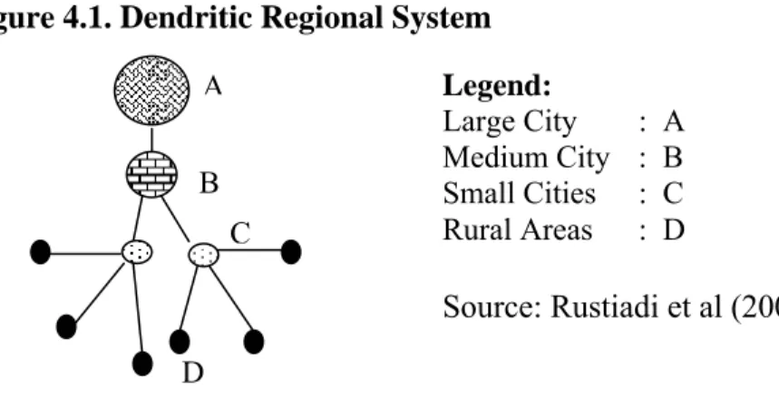
Figure 4.1. Denritic Regional System 107 Figure 5.1. Conceptual Research Framework 138
Figure 5.2. Path Diagram 139
Figure 6.1. The Level of Education Attainment in Ampel 152 Figure 6.2. Agriculture-Related Occupations in Ampel 154 Figure 6.3. Graph of Staple Food Consumption in Selected Sub-Districts, 2005 157 Figure 6.4. Production of Main Food Items in 2005 158 Figure 7.1. Ampel Sub-district Map and Nodal Points 174 Figure 7.2. Map of Ampel with Elevation Information 190 Figure 7.3. Map of Ampel with Road Network Information 191 Figure 7.4. The Industrial Linkage Network in Ampel Sub-District 199 Figure 7.5. Diagram for Industrial Linkages in Ampel Sub-District 207
LIST OF APPENDICES
Appendix 1 Urban Area Development Process Illustration (Combination of 283 Spatial Development Theories)
Appendix 2 Degree of Leverage 285
Appendix 3 Summarized Flowchart of Literature Review of Empirical Studies 286 Appendix 4 Spatial Linkages Analysis for Iron and Steel Firms in the USA 287 Appendix 5 The Fundamentals of Structural Equation Modeling 289 Appendix 6 West Java Origin-Destination Transport Data in 1996 300
from the Indonesian Ministry of Transport
ACKNOWLEDGEMENTS
I would like to extend my sincerest gratitude to my supervisor, Professor Sinha, for his undying support and excellent guidance. Without his support, I would not have been able to complete this thesis. I will always be sincerely grateful for all his kindness and understanding. I certainly look up to his professionalism as an academic, and remember all his valuable advises in my future career. I would also like to extend my sincerest thank to all APU professors who have helped me throughout the course of my study, including Professor Nair and Professor Kuchiki for their recommendations in my application. I thank Professor Zhang Wei Bin and Professor Cooper for kindly sparing their busy time to discuss my research and they have certainly given me very useful advice in the aspects of location theories and regional development. I thank Professor Miyoshi for his advises and continuing support.
I thank Professor Monte Cassim for his continuing support, and his kind help in lending a hand as a former UNCRD expert, in giving useful inputs on Agropolitan and the concepts of regional development. I thank Dean Yamagami for his kind support and understanding throughout my studies. I also thank Professor Fukui for his kind support and understanding. I thank Professor Hayashi for his kind help during the difficult time in my early stage of PhD. I thank Professor Eades for his great advice and Professor Mani for his suggestions and support as the PhD coordinator. I thank Professor Kee Po Kong for giving inputs on my dissertation.
I have also to thank the supportive and helpful staff from the academic and research offices, Ruth Archbold, Miyoshi-san, Earl Goodman and Belinda. I also thank the staff of the student office who have given support and help in my student life, Kimiyama-san, Nonaka-san, Goto-san, Kato-san, Inoe-san and all other staff members whose name I have not mentioned.
I am indeed thankful to my father, a PhD himself, who has given me the inspiration and become my role model. His support has been instrumental throughout my course of study, and I hope I can always make him proud. I thank my mother for her love and care, and her undying support. I also thank my sister, Mila, and my brothers, Eril and Eron, for their great support. I am always grateful for my family members who have been very
supportive to me. I also thank Evan, Romi, Rizki, my beloved cousins, and my aunties and uncles, as well as my grandmother, for their continuing support.
I have to thank my friends, who have made my life in Japan very enjoyable. I thank Indra, Cicha, Nuki, Yandri, Ivan, Trie for being the kindest of friends to me. I also thank my PhD colleagues, Kumar, Himanshu, Villiami, Fred, Dulal, Palentina, Victor and others whose name I have not mentioned, for their suggestions and support. I thank my seminar class members, Sohel, Parvesh, Mariam, James, Jahangir and others whose name I have not mentioned, for being such great classmates to me. I am very thankful to Clarissa Wilanda for her kind assistance in the revision of this thesis, as well as to Marsha for her valuable help.
I am thankful to those in Indonesia who have given their support and understanding. I am certainly indebted to the Spatial Planning Team, Dr. Deni, Mr. Hadian and Mr. Darto for their assistance in my fieldtrips and surveys. I also have to thank Mr. Iman, Mr. Dwi and Mr. Sanusi from the Ministry of Public Works. I also thank Ernan Rustiadi for his advice and cooperation in discussing the concepts of Agropolitan. Their support has certainly been instrumental in throughout the course of my study.
I also thank my employers and work colleagues who have granted me necessary leave for the period of this study. I thank Rudy Willem, Raj Kannan and Syarif Puradimadja, from PPITA project,. I also thank Migara Jayawardena, Sati, Eka and Hanny from World Bank Energy Team. I am certainly thankful to my IEU University partners, Mrs. Retna Suliati for her kindness and understanding, Prof. Kemala, Dr. Arief, Dr. Yanti and those whose name I have not mentioned, for their continuing support.
I am also thankful to Dr. Dadang and Mr. Goodwin, who have given me recommendations three years ago, which helped me enter the graduate school of APU. I am thankful to Neil Powe from the University of Newcastle Upon Tyne, who has kindly given me inputs for the questionnaire.
Last but most importantly, I thank Yuke Irawati for her patience, understanding, and her continuing support and care. I thank her for being beside me all the way, throughout the good and bad times. I am also grateful to her family for their continuing support and understanding.
EXECUTIVE SUMMARY
This thesis focuses on the development of agricultural-based small urban areas in rural regions. The interregional development in Indonesia has been characterized by imbalances in the rural-urban linkages. The discussion on urban and regional economic theories and the empirical studies have shown the potential development of small urban areas in predominantly agricultural rural areas. The criteria for the selection of research area were defined by drawing upon the various interpretations of Agropolitan. Ampel sub-district in Boyolali District, Central Java, was chosen as the research area. Ampel has an established agro-business system in the cattle rearing sector.
The analysis on the accessibility factor shows the importance of accessibility in urban development. The calculation of spatial industrial linkage indices shows that Ampel has a balanced rural-urban linkage, which is characterized by high magnitude and market size for the rural sectors. The high concentration of rural sectors’ forward linkages to the Ampel city shows the significant role of Ampel city in the cattle rearing industry. The moderated structural equation modeling for Ampel shows that the residents’ willingness to travel has insignificant effect on the positive relationship between accessibility and the usage of small urban center. The model also shows that the residents’ modernity has significant effect on the negative relationship between rural amenities and the usage of small urban center.
Overall, agricultural-based small urban areas can develop the rural economy by benefiting from economies of scale that is subject to high accessibility, concentration of forward linkages and the development of urban amenities that meets the needs of the local people.
CHAPTER I
INTRODUCTION
1.1. Background
The development of agricultural-based growth centers urban areas was inspired by the desire to develop the rural economy. The rural economy has a tendency of being dominated by low value-added agricultural activities with consistently decreasing land productivity and the high risk of loss arising from fluctuations in the prices of fresh farm products. This condition along with the population growth has brought villages to the point where they can no longer sustain their populations in terms of job creation. This leads to rural-urban migration, which has adverse impacts. However, there is an important distinction that must be made between different kinds of rural-urban migration.
This research argues that rural-urban migration has detrimental impacts when the migration takes place from rural area to metropolitan areas located far away from the rural areas and not if the migration takes place from rural areas to a nearby small to middle-sized urban area. We believe that the latter form of migration indeed creates healthy rural-urban linkages. In addition, it is also important to distinguish between day-time population and night-day-time population. Migration that contributes to the increase in day-time population in the urban areas is usually because of commuters who live outside the urban areas. However, again, a distinction needs to be made between commuting that takes place in the metropolitan areas and that which takes place in small to medium sized urban areas. The former tends to take place from suburban areas to urban areas and is a
clear indication of urban sprawl. The sprawl usually has a combination of concentric and linear growth pattern.
Urban sprawl has been the major feature in the development of “primate” cities. The sprawl is due to the centralized governance in Asian countries such as Indonesia, Thailand and the Philippines (Anwar, 2000). The primate is defined as the excessive growth of the largest metropolitan areas in a country (Mills and Hamilton, 1994). Preferential treatment in terms of state budget allocation to capital cities can, however, lead to a significant disparity in urban amenities, and suppress the growth of other urban areas within the country. The population of Jakarta, the capital city of Indonesia, has grown at an average rate of 4.59 percent per annum from 1961 to 2002. The population increased from 2.9 million in 1961 to 8.4 million in 2002. With 3.95 percent of the national population residing in Jakarta, the local GDP of Jakarta has reached 15 percent of Indonesia’s GDP and this clearly indicates how Jakarta has grown to become a primate city (Kasikoen, 2005).
Although the other metropolitan areas in Indonesia may not yet qualify as primate cities, these metropolitan areas including Medan in North Sumatra, Surabaya in East Java, Bandung in West Java, Semarang in Central Java and Makassar in South Sulawesi, are also growing rapidly. Henderson and Kuncoro (1996) find that in Java Island, there is an increasing degree of population concentration in four metropolitan areas, namely Jakarta, Bandung, Surabaya and Semarang. For these cities, the population increased by 32 percent and industrial sector labor increased by 51 percent during 1961 to 2002 (Kasikoen, 2005). We cannot consider the development of other cities in Indonesia as a sign of equitable development, because these are simply replications of the similar
pattern of over-concentration as that of Jakarta, but on a smaller scale. The growth of these cities has gone beyond their carrying capacity in terms of employment opportunities and infrastructure provision. In addition, these cities have not contributed to healthier rural-urban linkages. If this trend continues without any improvement of employment opportunities and infrastructure in the cities, these cities will face the threat of unsustainable development.
As mentioned above, the growth of Jakarta, and subsequently the other metropolitan areas in Indonesia, is a result of the preferential treatment to these cities. Although industrialization that took place in the 1970s and 1980s led to a fall in the contribution of agriculture to GDP, Indonesia has failed to maintain healthy rural-urban linkages. Garcia (2000) sees this policy as an urban-biased policy that creates significant disparities in development and leads to rural areas being left behind in terms of economic development. Anwar and Rustiadi (2000) see the development policy in Indonesia as pursuing the creation of growth poles with a spatial polarization of development efforts to a few cities. The initial intention was to make smaller areas act as growth centers and this was expected to lead to trickle down effects within the cities’ hinterland. However, in reality, rural resources are being drained by these cities and no beneficial developmental impacts are being enjoyed by the hinterlands.
Harun (2006) explains that this growth pole strategy relies on four main sources of financing. Three of the sources connect national economic development to the global capital system. These are export of primary goods, foreign investment and international aid. The fourth source relies on the national economy’s capacity to save, particularly on the agricultural sector and taxation. During the 1970s, the government of Indonesia
mobilized savings and adopted an import substitution industry. The private sector at that time was very dependent on projects initiated by the government. The fact that the technology used for these industries was imported caused Indonesia to rely on abundant raw materials and cheap labor. Such advantages became unsustainable as the development in technology has led to a continuous increase in the productivity of the machines, decreasing the demand for labor. However, a lack of indigenous technological progress caused Indonesia to rely heavily on imported technology and rendered Indonesia’s past competitive advantage less effective.
At the same time, increasing population pressure has led to an upward pressure on food prices. However, farmers are least likely benefit from such price increases. Their general lack of access to infrastructure has caused farmers to rely on intermediaries in marketing their produce. Most of the profit margin is actually enjoyed by these intermediaries, due to the low bargaining power of the farmers. At the same time, the government is continuously faced with the dilemma caused by the trade-off between cheap food policies and industrial development. Thus, in response to the upward pressure on food prices, the government has resorted to a cheap food policy. This policy involves import of rice and different forms of market interventions.
It is reasonable to argue that cheap food policy is also instrumental in ensuring that poverty is kept in check. However, this triggers a vicious cycle, because the government has been focusing too much on the urban poor, in its poverty eradication strategy. In the rural areas, poverty is experienced by farmers, and the cheap food policy affects their income. At the same time, the cheap food policy at the expense of rural farmers is distorting, because urban areas continue to be attractive to potential migrants
as this urban-favoring policy disguises the limitations the urban areas have in providing employment opportunities. It can therefore be argued that Indonesia’s urban areas have grown at the expense of rural areas. This is due to the policy of growth pole creation. Industrialization as the fuel for urban growth is largely dependent on the supply of cheap labor.
Harun (2006) argues that farmers also suffer from the fact that they cannot be isolated from the urban economy. When they transact with the urban economy, the inflationary pressure in the urban area is “exported” to the rural areas because farming equipment and supplies tend to have price increases at a faster rate than the food prices. Another important issue that is related to the cheap food policy is the fact that the urban labor force is seen as a strong political force to the government. This has encouraged government to stabilize food price to ensure urban labor political stability.
Rustiadi and Hadi (2006) identify other possible causes of the backwash effect in Indonesia’s regional development. The first is the fact that access to villages often encouraged urban elites and central bureaucrats as well as large corporations to exploit the rural resources. These rural communities were unable to defend themselves due to their lower bargaining power. Second, rural residents have low human resources capital and weak institutional capacity. This handicap made it difficult to disseminate the ideas and modern concepts of rural development. Therefore, most activities take place in enclave form by bringing in human resources from outside the villages.
According to Rustiadi and Hadi (2006), even if the urban areas remain healthy despite the sickness of the rural areas, this is not a sustainable condition, because eventually the disease in the rural areas will spread to the urban areas. This seems to be
the scenario that Indonesia might face. Harun (2006) opines that the rural areas in Indonesia are considerably overpopulated if density is measured by the size of farmland per household. This is particularly the case in Java, where the average ratio of land to household is less than 0.3 hectare/household and is consistently decreasing. In many cases, farmers do not own their land and become landless peasants who must give around one-third to a half of their produce to their landlords. In relation to the decreasing ratio of land per farmer, Dardak (2004) points out the danger of land degradation caused by over-intensive cropping that has drained soil nutrients. A field trip to Malang’s apple farms shows an example of how over the years intensive cropping has caused the soil to lose the critical nutrients. As a result, the farms experienced decreasing yield both in terms of quantity and quality.
The unsustainable farming condition in rural areas has caused urban areas to experience migration from rural areas beyond what they can accommodate, leading to social problems. The cheap food policy has been the key to the survival of the urban areas but if this issue remains unaddressed, food scarcity will undoubtedly take place because of the imbalance between urban food demand and rural food supply. The recent controversy over import of rice has been a real example of such a danger. The food price will inevitably increase, and the government’s decision to import food in stabilizing the price will be at the expense of local farmers who will face significant decrease in income, since they will have to sell a lower quantity at the same price. Farmers may decide to give up farming and move to the cities in search of the “superficial”1 urban opportunities. One
1 The word superficial is used to describe how the urban areas seem to provide endless opportunities for
migrants, while in reality, this is not the case. This is because the urban areas’ sustainability relies on cheap food supply from the rural areas and the actual growth of industrial employment is lower than the number of rural to urban migrants.
may argue that the migration will solve the issue of overpopulation in the rural areas. However, the prevailing unemployment in urban areas shows its inability to create enough employment opportunities for the migrants, which further results in a vicious cycle leading to urban social problems and overexploitation of rural farm lands in pursuit of larger and cheaper food supply to feed the urban population.
Secondary and tertiary economic activities have been concentrated in the urban areas in pursuit of rapid growth. This involves transporting rural produce over long distances for processing or even for simple packaging and sorting. During the 1970s and 1980s, when the supply of gasoline was abundant and fuel subsidies were still feasible, the impact of long haul was hidden by the low price of fuel. However, now Indonesia has become a net importer of fuel. The phasing out of subsidy has caused a problem in the logistical arrangement. As fresh farm products with low value added are transported over long distance, the cost of transport as a percentage of the final price increases.
There is an opportunity for the rural areas to process their produce so that they can cope with the increasing burden of transportation costs. Minimizing the distance traveled between farm gate and the subsequent processing or handling may become a critical factor in reducing the cost of transportation. This would also create alternative employment opportunities for the rural population. However, Dardak (2005) points out that the challenge in such rural development program is the small scale of operation that makes it infeasible for a manufacturing industry to operate.
Friedmann and Douglass (1975) propose the Agropolitan concept as an alternative for regional development. The concept relies heavily on the development of an urban growth center, which is located within 5-10 kms or an hour of cycling from its hinterland.
This concept allows the leveraging of investment as more than one village is involved and the investment can be focused on the growth center village that is most accessible, so that the catchment is also optimum. The government of Indonesia adopted this concept in rural development in 2002, with particular focus on the development of infrastructure such as rural roads, market and irrigation (Rustiadi, 2004). This program follows the “trade follows the ship” principle, where infrastructure provision precedes the demand and is expected to encourage economic activities and concentration of post-farm distribution in the growth center by the hinterland villages so that economies of scale can be realized.
1.2 The Challenges Faced in Agropolitan Development
The Agropolitan program has now been in operation for four years, and the evaluation process for the initial phase of the project has been conducted. The agencies involved in the implementation and evaluation are the Ministry of Agriculture and the Ministry of Public Works. Researchers from Bogor Institute of Agriculture, Bandung Institute of Technology and Gajah Mada University, Yogyakarta helped to create the conceptual framework for the Agropolitan. This conceptual framework will be the result of an analysis that shows how an agropolitan system operates in terms of its socio-economic spatial arrangements.
Indonesia is a pioneer in implementing Friedmann’s concept of an Agropolitan, but there is still no clear implementation criterion and model for this type of development. A Bogor Institute of Agriculture publication in 2006 discusses the possible concept of an Agropolitan. The author of this thesis was given the privilege to participate in the National Workshop on Agropolitan development in November 2005, where the
Agropolitan concept was defined for inclusion in the government’s policy and regulatory framework.
The evaluation by the Directorate General for Urban Rural Development of the Ministry of Public Works (2004) was based on the infrastructural construction and its impact on farmers’ revenue. A working example of an Agropolitan growth pole has not been yet properly identified in Indonesia. An Agropolitan is a way of achieving the development of small urban areas in the agricultural-based regions to facilitate rural development. The evaluation system in 2004 focused on the revenue impact without paying much attention to changes in spatial structure. As a regional development strategy, it is important to evaluate the impact on spatial structure, especially in assessing the presence and even further the effectiveness of a small urban area in an agricultural region.
Anwar (2006) defines the agenda of Agropolitan development, which is to develop a small urban function center. This urban function center acts as the service center and should be equipped with urban facilities such as clean water, electricity, a market center, entertainment, financial institutions, post primary education, road network, transportation system, communication facilities and other economic activities. These centers are the critical gatekeepers to filter the rural migration to metropolitan areas as they serve as centers for off-farm employment and services provision.
The fact that the evaluation process tends to exclude the analysis of changes in spatial arrangement, shows the need for a clear working example of an Agropolitan.The November 2005 National Workshop on Agropolitan and Metropolitan, has given a clear direction on the concept of an Agropolitan. Nevertheless, this concept requires a working
model that can be obtained only by empirical analysis. This working model should feature a real example of an agro-based small urban function center.
1.3 Research Objective
This research seeks to establish a working model of an Agropolitan. This will help the government in designing Agropolitan projects and evaluating existing projects in terms of the changing spatial arrangements.
The objective is to develop a conceptual framework based on literature review and a theoretical framework, and to use this conceptual framework to identify the research object. The empirical analysis is conducted to find a real life example of an agro-based small city, or at least a small city that is close to being an agro-based small city but lacks certain traits that are required in the conceptual framework.
The research questions are: For the theoretical and literature review:
1. What are the factors that contribute to the growth of urban areas, in particular the process that takes place for a non-urban area to become an urban area?
2. Has there been any development of agro-based small urban areas in other countries and what are the issues faced?
3. What are the current concepts and ideas for an Agropolitan? For the empirical analysis:
1. What is the role of accessibility in the development of an agro-based small city in the research object?
2. What is the pattern of agricultural industrial linkages and do they display concentration of activities?
3. How do the socio-economic background and other factors influence the individual villagers’ decision to utilize the rural small town?
1.4 Scope of Research
This research looks at urban and regional economic theories as well as related literature in conceptualizing a working model for an Agropolitan. The research selects one project from the list of on-going Agropolitan projects and potential Agropolitan projects. The selection criterion is based on the conceptual framework. A working visit is conducted only to the shortlisted project areas. The focus is on the role of accessibility, villagers’ socio-economic background, urban amenities, interaction with other urban areas and the industrial linkages.
1.5 Significance of Research
Many countries place a heavy importance on agricultural sustainability. The empirical-based working model will provide more accurate guidelines for implementation compared to a pure theoretical working model. This research is the first in analyzing the industrial linkage pattern of a small agro-based city in Indonesia, and the role of accessibility. The role of accessibility is also important in designing spatial plans and road network as well as urban interactions.
The research also takes into account socio-economic factors that influence villagers’ decision to utilize the small city for employment and access to services. The working model can also serve as a guideline for potential development of similar rural
development projects in other Asia Pacific countries. The industrial linkages analysis is limited to the flows of goods within the region, and only includes the sectors related directly to the main commodities produced in the region. The exports from the region are not included in the analysis.
CHAPTER 2
THEORETICAL FRAMEWORK
2.1. Introduction
Theoretical studies form an integral part in understanding the processes leading to the emergence of an urban area. This chapter discusses theories of urban and regional development to depict an overall picture of the various intellectual interpretations of the mechanisms behind the emergence of an urban area. The research objective of this dissertation is to analyze the development of agriculture-based small towns. Hence there is a heavy emphasis on understanding the mechanisms of an urban area formation.
In relation to an Agropolitan, the role of agriculture-based small towns in facilitating a balanced rural-urban linkage pattern is very significant. The intense interaction between the hinterland villages and the market town, which is created through backward and forward linkages, is the most important characteristic of an Agropolitan region. The market town is basically a central point in the region that serves as a market center to collect the produce from the rural villages and distribute urban services. This market center develops into an urban center or market town through concentration of secondary and tertiary activities as well as a certain degree of population concentration. However, we can narrow the scope of population concentration to day-time population, instead of night-time population. Day-time population includes those who live in the hinterland villages but work in the market town while night-time population excludes such people. The assumption that the market town has high accessibility from every point
in the Agropolitan region also means that the villagers do not need to reside in the market town because travel is easy.
We look at various theories that explain the mechanisms of urban growth. The processes that lead to urban growth will serve as useful inputs to construct a working model for an Agropolitan. Most of the theories are within the field of urban and regional economic development. There are various names for urban and regional economics field, which include among others, urban economics, regional science, regional economics, economic geography and spatial economics. All the theories in urban and regional development try to integrate spatial aspects in explaining the process of economic development. We discuss the process that leads to the establishment of urban area, in particular, the criteria in terms of economic activities and spatial arrangements.
2.2. The Early Location Theories
The major original spatial economic theories were all outside the Anglo-Saxon tradition, mostly due to the fact that these works were written in language other than English. They were mostly in German. The major spatial economists were von Thunen (1826), Weber (1909), Christaller (1933) and Losch (1938). Although these theories adopt different approaches, there is a common feature shared by these theories as they all are directed towards understanding how the behavior of economic agents in making location decision for economic activities leads to the emergence of activity centers as embryos of cities. Section 2.2 discusses the early attempts in integrating spatial dimension with economic development. These include the works of von Thunen’s work on isolated state, Weber’s work on industrial location theory and the theories of market area of Christaller and Losch.
2.2.1 von Thunen and Weber
von Thunen (1826) observes the pattern of land use in an agricultural economy by referring to his own managed plantation. His work was the first to explain the spatial mechanisms that lead to the emergence of an urban area. According to von Thunen, the urban area is at the core of the agricultural economy, which acts as the market area. This market area is surrounded by agricultural rings where each ring cultivates a specific crop associated with the highest bid rent made for that particular ring. This bid rent is calculated on the basis of revenue and expenses, including cost of labor and transportation. The main idea of bid rent is that the activities that take place in a particular ring will have to generate revenue sufficient to cover the operational cost, in particular transport cost. Thus, the farther away the agricultural ring from the core, the more revenue it has to generate to cover the transport cost.
The trade-off between transport cost and bid rent is the main feature of an agricultural economy’s land use. Commodities such as vegetables and fresh milk are produced in the agricultural ring that is nearer to the core, because these products are highly perishable and require minimum transport time. In contrast, commodities such as wheat can be located farther from the core because they can withstand long haul. It is important to note that transport cost is not only seen from the perspective of monetary cost, but also time cost. Hence, products that cannot withstand long haul, such as vegetables and fresh milk, need to be located in the agricultural ring closer to the core, which requires higher bid rent. This shows that it is not only the crops’ relative price that determines the ability of the farmers to pay for the land rent. The inherent characteristics
of the crop such as its perishability, determines whether it needs to be located nearer to the core or not, and thus determines the price received and the potential revenue gained.
Although inherent characteristics of crops affect the price due to the necessity to locate nearer to the core area, those located farther from the core area need to incur higher transport cost and this also translates into a higher price. Therefore, it is not acceptable to judge the commercial value of a crop based solely on their location decisions. The benefit of locating near to the core market, according to von Thunen, is strictly confined to the transportation of farm produce. Nevertheless, activities that are not dependent on the market area have the freedom to pursue the lowest possible land rent without any worry about transport costs.
There are some exogenous factors that may affect the operability of farms. Demand may affect the price of the commodities and the possible intensification of farming may reduce the need for larger land space. In the presence of intensification, the sacrifice of paying higher rent can be offset by reductions in transport costs. Higher demand for a product may also lead to a disproportionate trade-off between transport costs and bid-rent because the savings in transport costs may exceed the higher bid-rent paid as the quantity of goods transported is higher.
von Thunen showed that market function plays a significant role in creating an urban area. The presence of a core market affects productive activities and their respective locations relative to the distance from the core area, which is further influenced by the demand for the product and the possible intensification measures. He explains the spatial arrangements of a functional region, and simply attributes urban growth to the development of a market for agriculture produce.
Weber (1909) provided a very useful addition that fills the missing piece in the process of urban growth from von Thunen’s theory. Weber explains the emergence of a locational structure with particular reference to the general contributing factors. Weber starts with the initial condition where people occupy an undeveloped land area that will later become established as an isolated economy. The first phase is the establishment of agricultural stratum that produces the necessary items required for human survival. The people who are engaged in farming will then demand consumer goods. To satisfy this demand, surplus labor from the farming sector will be engaged in primary industries that are located away from the first stratum. This location where industrial activities take place becomes the second stratum and is called the primary industrial stratum. The combined demand for secondary industrial goods from the people working in the agricultural stratum and the primary industrial stratum are then satisfied by the surplus labor from these two sectors who engage in secondary industrial activities. The location for secondary industries is named the third stratum, located away from the second and first stratum.
These three strata are the basis of an isolated economy. The demand for services from the people working in these is satisfied by additional surplus labor that engages in central organizing activities. These service and administrative activities take place in the fourth and fifth stratum. As we can see, the farm activity extends economic activities outward and as the location goes outward from the farm, the economic activities that take place shift to secondary and tertiary sectors. If we assume that more than one farm activity unit is doing the same thing, and these farm activities are located within a concentric line, there are directions where the outward movements of these units will
converge and the further the outward movement, the more farm units are included in the converged points. If we further assume that the secondary activities will take place in locations where the most number of people can be served, we can see the agglomeration of activities taking place through this outward movement. As a farm unit decides to extend its economic activities in establishing a second stratum for primary industries, another adjacent farm unit may decide to do the same thing and thus the second stratum may involve more than one farm unit.
As the second stratum comprising of two or more farm units expands into the third stratum, two or more second strata may have a point of convergence. Thus, the third stratum may involve more than one second stratum. As this process continues, the final point will be a convergence of all the farm units that can be connected in one concentric or circular line located in the outermost of the circular region (refer to appendix 1 for detailed illustration of this process).
Weber (1909) follows the concentric pattern of land use that von Thunen uses, but explains in detail how the core area is created. von Thunen created the impression that the market place is the central point in the isolated economy, and insisted that activities originate from that point. In contrast, Weber’s theory can be interpreted as an outward movement, where the region gets developed initially from the outermost circumference of the circle, which depicts the region, and as it extends outward from the farm points, this extension instead becomes an inward movement as all the points within the circumference line converge into the central nucleus or core of the circular region. This explains how conglomeration or agglomeration of activities takes place and how economies of scale contribute to the creation of human settlements and urban areas. The
central organizing strata or the fourth and fifth stratums, are most likely the urban core which von Thunen is referring to in his theory.
However, if we note that the locations where second or subsequent stratums take place were initially used also as farm locations, we can see how agricultural activities get driven away. As the point of convergence between two or more farm units create economic value of land, farm activities are no longer profitable because of the low value-added. Thus, primary industries that offer higher value-added and is able to produce at the demand required for more than one farm unit is considered more suitable to be located in the land with a higher economic value. This process continues until the core area, where all the possible points have converged is formed, and the highest value economic activities take place in this area. This explains how competition for land use as hypothesized by von Thunen, is also applicable to Weber’s theory.
From both Weber and von Thunen’s theories, we can see endogenously derived creation of cities that takes place due to agglomeration of activities2. The surplus labor to be had because of intensive farming or population growth can be engaged in primary industries. This process continues until it is possible to produce tertiary goods and services. Thus, the pre-conditions of an urban area is the sufficient catchment area or population size that it can serve, which is largely determined by the location. The process takes place naturally where locations that can serve more people will have higher economic value and thus higher value activities that satisfy the demand of more people replace the primary activities that have lower value added.
Weber (1909) also developed a location theory that is based on the following assumptions: firms exhibit constant return to scale along with technological improvements; factors of production are infinitely available anywhere or be located at certain locus of production or supply; the demand is known and fixed in terms of space and amount, and the transport cost for the commodities increase in proportion to the increase in weight and distance of the goods being transported. Based on this theory, the location that gives the optimum profit for the firm is determined by minimizing both production and transportation costs.
This theory is also well known as the Weber triangular problem. The problem is that a firm that is faced with the decision to locate its factory to minimize the cost of serving a particular consumption site. The problem is named the triangular problem because there are two sources of raw materials that are required for the production activities and there is a market center located at the third point. Hence, if linked, these three points form a triangle.
Weber shows that the location giving optimum profit is located within the triangle, and this location is determined on the basis of the relative strength of the pull forces for the two sources of raw materials and the market center. This theory is the main point of discussion of regional science scholars, including Isard (1956). Isard’s theory on Weber’s triangular problem is discussed in a later section of this chapter.
2.2.2 Christaller and Losch
This section looks at the central place theory developed by Christaller (1933) and Losch (1939) that build on Weber and Thunen’s theories. The central place theory is, however,
constructed under strict assumptions. Newer theories such as those developed by Isard (1956) and Alonso (1964) have been constructed under a more relaxed assumption in updating the central place theory. These newer theories will be discussed in the later sections of this chapter.
Christaller (1933) provided an empirical analysis to further explain and build on Weber and Thunen’s theories. Christaller studied a large number of market towns in South Germany where every group of market towns were focused on a larger administrative center. This center is also a market town, but is larger in scale and scope. This relationship continues as the smallest market towns are linked to the second smallest market town, and this second smallest market town is linked to the larger market town until the second largest market towns are linked to the largest market town. This hierarchy of relationship is the main point of Christaller. The inward centralistic manner of relationship shows that a hierarchy exists in the settlement pattern. Christaller also found that settlements of typical size tend to be spaced regularly. The empirical findings show that population of several sizes of typical settlements tend to bear a regular relation between each other, and the distances separating any pair of similar size settlements tend to increase by √3 as one proceeds from a given settlement size to a settlement of the subsequent higher size.
Losch (1938) added another important dimension to Christaller’s findings. Losch looked at the process of urban settlements by collecting additional empirical evidence. His finding is also a rebuttal to Palander’s (1935) view that in the absence of pure competition in modeling spatial economics, general equilibrium can never be obtained.
Losch’s work features a highly simplified static model of a space economy that operates under monopolistic competition.
It is, however, important to note the strict assumption by Losch of a broad and homogenous plain economy with uniform transport features in all directions and with an even scatter of industrial raw materials in quantity sufficient to facilitate production activities. The economy also has a uniform distribution of agricultural workers as well as population that have the same set of tastes and preferences. Losch also assumed that each farmhouse is self-sufficient in the beginning and technical knowledge gets disseminated throughout the economy with production opportunities available to all the people.
Economies of scale is assumed to be the inducing factor for production of a commodity that is beyond the farmhouse’s basic needs. Thus, if the farmhouse finds production of a secondary or tertiary commodity to be profitable, it will produce the commodity to serve a certain market area that is depicted to take a circular form. However, since production opportunities are available to all farmhouses, if a farmhouse finds it profitable to produce a commodity in surplus, so will the others, and thus the force of competition will eliminate excess profits and alter the market area. This alteration not only leads to smaller market size for each farmhouse, but also changes the shapes of the market.
Ultimately, the market area transforms from a circular form into a hexagon form. The hexagon market area is seen as an ideal economic form of market area, and is sustainable because the net of the hexagonal market will completely cover any area under consideration. In contrast, a circular area will still leave empty untouched corners. Other possible shapes may be triangles, squares and octagons. But, only a hexagon deviates the
least from the circular form and at the same time allows minimization of transport costs in supplying a given demand. Thus, a hexagonal form has a circular form’s advantage of allowing maximization of demand from the population in the given area and at the same time, is better than the circular form because it does not leave any empty untouched corners.
As conceptualized, Losch’s argument is that for each commodity, the economy can be depicted in the form of a geometric plane that is dissected into a honeycomb or a net of hexagons of market areas. Losch further groups these honeycombs according to the size of the respective market units. The varying sizes and the relationship between the smaller and the larger markets create a system of nets that conforms to Christaller’s hierarchy of market centers.
The combination of the system of nets and the hierarchy of market area is well-known as Central Place theory. The strength of this theory is its ability to help simulate how shocks, shifts or changes in the economy can affect the economy from a spatial perspective. This effect takes place as producers, retailers and service providers from each hierarchy interact with one another in a vertical and horizontal manner. Horizontally, they interact with activities at the same hierarchy or size. Vertically, they interact with activities at the smaller and larger sizes or lower and higher hierarchies.
However, as discussed earlier, this theory is based on a very strict assumption of an even distribution of opportunities in a homogeneous place, which is contradictory to the fact that people tend to cluster in areas where more facilities and amenities are available. One way to overcome this possible drawback is to relax this assumption and to adjust the system of hierarchy with possible variations in opportunities along the
homogeneous plane. Despite this drawback, it is important to recognize the fact that Christaller and Losch provide an answer to how economies of scale and transport costs interact in determining the spatial structure of an economy.
Another possible drawback of Central Place theory, according to Krugman et al (2000), is its failure to explain how individual actions also play an important role in causing the hierarchy and how this hierarchy is sustained once created. The theory fails to acknowledge the fact that dynamisms in the economy may emerge from the actions of economic agents. Krugman et al (2000) suggest the use of Central Place theory as a classification scheme and a way to organize perceptions and data, but warn against using this theory as an explanation of the economy’s spatial structure.
2.3 Major Works on Spatial Economics in the 1950s and 1960s - The Classical Location Theories
This section will mostly be focused on Isard’s (1956) seminal work on general theories of location and his disciple Alonso’s (1964) work on urban land use. Both these works were path-breaking in regional science. They successfully assembled previously scattered theories and studies.
2.3.1 Empirical Regularities in Space-Economy
Isard investigated empirical regularities in the spatial economy as a justification for the need to develop location theory. Isard also refers to Losch (1933) and Christaller (1938) where as one proceeds from smaller to larger class sizes of cities, the distance separating cities of like class size increases, although with considerable variation around an average.
Isard (1956) refers to Zipf (1949), who conducts a study on the association between city size and the market area complex. Zipf used a graph that plotted the weight of shipments between any pair of cities and the corresponding P1P2D (P1 and P2
represent population of two given cities and D represents distance) distance factor. Zipf found a definite inverse relationship between tonnage of railway cargo and distance. Stewart (1950) used Newtonian physics in observing the relationship between volume of trade and spatial distance. Stewart’s theory was that the demographic (gravitational) force F of attraction between two groups of N1 and N2 average Americans separated by r
distance is given by 1 2 2
r N N
F = where F acts along the line joining the two groups.
Stewart’s theory is also known as the gravity model.
According to Stewart, the “gravity potential energy” that a group of N1
individuals exerts on the location where the second group is located is given by
r GN
V 1
2 = where G is a constant that determines the demographic energy when
multiplied byN1N2r . The term “gravity potential energy” refers to the influence that
one area has over the other area. When referring to the influence one area has over a certain region, Stewart used the equation =
∫
DdSr
V 1 where D refers to the density of
the population over area, dS. The integral in this equation covers all the points within the region where the density of the population is not zero. According to Stewart, the influence that one area has over a certain region is also an inverse measure of the area’s proximity to the total population. In other words, this influence over a certain region also
indicates how accessible the location is, relative to other locations. Accessibility is discussed in detail in a later section.
The empirical regularities present in Zipf and Stewart’s findings led Isard (1956) to the conclusion that the friction of distance is present and affects the spatial structure of an economy. Therefore, transport infrastructure plays an important role in altering such a structure. Isard incorporated transport into his model by treating transport as a production input. The transport input is seen as a derived input obtained from the service of the basic production inputs, which are labor and land. In other words, the producer has to choose between allocating the labor and land inputs for transportation or for cultivation. Thus, any decision to produce within a greater distance from the market implies that the producer anticipates greater returns. A greater return is obtained as the investment in labor and land inputs for transportation of products is offset by the savings in transportation cost3. In Isard’s model, the transport input is seen as an indirect labor input that is a substitute of the direct labor input.
2.3.2 Transportation Input and Agglomeration Economies
Isard (1956) simulated a condition where a firm is faced with more than one point of raw materials or input source and market points. This simulation shows the problem where a firm has to substitute a closer distance to one input source at the expense of longer distance to the other input source. If the firm decides to locate near the market, the firm also has to substitute closer distance to market at the expense of longer distance to raw material sources. The main objective of this simulation is to find the location that
3 There is trade-off between the investment in labor or land inputs for transport and the labor or land inputs
minimizes the overall transport costs. Transportation cost is a function of distance and mass of the inputs or finished products.
It is important to note the elasticity of transport cost to distance, whereby the increase in transport cost from zero distance to a distance slightly more than zero (i.e. from 0km to 0.1km) is significantly higher compared to the increase in transportation cost from distance more than zero to a slightly longer distance (i.e. from 1km to 1.1km). Because of the elasticity of transportation cost to distance, Isard argued that the most efficient location is located in the corner of the polygon rather than the middle because it is always more efficient to have one of the inputs or outputs free of transport costs.
Isard (1956) also found that transport costs are the most important determinant of spatial structure. This finding was based on the analysis of relationship between three locational factors and the distance of settlements. The three locational factors are transportation and transfer costs, labor, utilities and financial service costs and factors that give rise to agglomeration and deglomeration. He found that only transport and transfer costs have regular variation with the distance of settlements, while the other two locational factors do not have any regular variation. This shows that transport costs are the main determinant in the formation of an economy’s spatial structure.
Nevertheless, this does not necessarily imply that agglomeration economies have no influence on the spatial structure of an economy. Isard explains how despite the lack of regular variation between spatial structure and the agglomeration economies, the factors of agglomeration can influence spatial structure. Hoover (1937) classified agglomeration factors into three categories, which are large-scale economies, localization economies and urbanization economies. Isard explains the relationship between the
factors of agglomeration and the creation of spatial structure. According to Isard, the relationship between large-scale economies as an aglomeration factor and the spatial structure of an economy, can be explained with reference to Losch’s (1938) hexagonal market area theory. Isard refers to the case of two different commodities with different marginal costs. The marginal cost of one of the commodities may increase sufficiently to allow for the division of market while the other commodity may have economies of scale extended over much larger range of products. In this case, for the commodity with economies of scale extended over much larger range of products, if the market area is enlarged, the gain in revenue outweighs the loss from incurring higher transportation costs. In contrast, the commodity with significant increase in marginal cost cannot have a larger market area since transport costs are higher. Therefore, a hierarchy of small and larger markets are created through a system of economies of scale, which conforms to Losch’s theory of market area hierarchy.
Isard refers to Weber’s (1909) theory on the reasons behind clustering of several firms or units, in explaining the relationship between localization economies and spatial structure. Weber sees the intersection of critical isodapanes’ between two or more firms as the condition for clustering. However, it is important that when clustered together, the unit can produce the requisite quantity in serving the combined market area efficiently. An isodapane consists of points of equal transport costs from the point of distribution. The critical isodapane is reached when savings in labor cost are just off-set by the increased transport costs (Pinto, 1977). When agglomeration takes place through clustering, the benefit of agglomeration economies that the firm gets is equivalent to the extra profit gained from serving the market beyond the critical isodapane.
According to Weber (1909), when two or more production activities have intersecting critical isodapanes, there lies a point where one larger unit of production can cover more than one of the production activities’ market areas. The point should have the lowest transport costs in relation to the total agglomerated output. However, Isard sees a possible weakness to Weber’s approach. Weber fails to explain the possible reluctance of firms to move to a new location, especially when the plants are already constructed. The significant opportunity costs in moving to a new location may create a strong bargaining power for existing plants so that new firms cluster around these existing plants. In addition, Isard argues that each production activity is reluctant to locate far away from its own optimum transport point. Thus, firms with greater bargaining power would be able to maintain their optimum transport point while those with less bargaining power would be forced to relocate near firms with greater bargaining power. However, Isard admits that Weber’s theory may be relevant for new development areas such as government-induced local actions, since bargaining power and existing preference of locations are not issues and can be altered through the government’s intervention. It is also important to note that transportation cost may not in all cases be an overriding factor for locational consideration, particularly when considering the contribution of transportation cost to the total cost that may vary from product to product.
Hoover’s (1937) third classification of agglomeration category, urbanization economies, involves the presence of localization economies or diseconomies. These localization economies or diseconomies include the larger pool of skilled labor, higher utilization of specialized and auxiliary industrial and repair facilities and large-scale buying and selling through brokers. Isard sees urbanization economies as playing a
significant role in determining the spatial structure. The localization economies encourage higher concentration or clustering of activities. However, localization diseconomies such as higher costs of living costs and congestions may limit the clustering of activities.
Weber’s isodapane approach can be used to explain how localization diseconomies and economies can influence the spatial structure. According to Isard, the use of isodapane is especially useful for development of new areas. Given the full knowledge of existing technology and possible changes to the technology, planners have an opportunity to plan the area based on the optimal spatial distribution and the hierarchy of cities with different sizes. However, isodapanes can also be used in existing land use if the objective is to alter the channels in the structure of the network to attain a situation closer to the optimum. Isard (1956) draws a graph that summarizes the economies and diseconomies in urban economic activities. This graph also shows the optimum urban population size for the respective economic activities to have efficient and feasible operations. Figure 2.1 shows Isard’s graph. Based on figure 2.1, the average optimum city size for all the urban economic activities is about 100,000 people. A later study by Fuguitt and Zuiches (1975) discovers that most of the residents living in rural areas prefer to be within 30 miles of a city over 50,000, which shows that the 100,000 people optimum city size standard in 1950 remains relevantly high if compared to the standard in the later years.
Figure 2.1. Economies of Scale for Urban Activities
Population
1,000 10,000 100,000 1,000,000
Annual net econo
m ies ($ m illion) Education Economies Power Economies Labor Economies Transportation Economies Total economies Source: (Isard, 1956, p.187) 2.3.3 Agricultural Location Theory
Isard (1956) also deals with agricultural location theory. He argued that rent differentials have always played an important role in determining the location of agricultural activities. However, the location theories for agricultural activities and industrial activities are still similar with regard to the trade-off between labor costs and transport costs. The only significant difference is the fact that agriculture producers are small in size and their markets are concentrated at particular points. Such a condition allows deeper locational analysis.
Isard’s disciple, Alonso (1964), focused on the agricultural location model. Alonso’s model features a single market for selling agricultural products and the land around the market are assumed to have similar potential for cropping. The model introduced the concept of bid rent whereby the more distant the land is from the market, the lesser is the bid rent as the producer has to incur more transportation cost. The