GCOE 1
This newsletter is to introduce one of the GCOE core sites in Mongolia.
Mongolian current situation
In Mongolia a very steep climatic gradient exists, from taiga cold forest in the northernmost are to hyper-arid desert in the
southernmost area. It provides various valuable study sites for rangeland ecology and management. Figure 1 shows the typical
ecological types including grassland in Mongolia.
Around 40 % of Mongolian population
depends on animal production, which again relies upon plant resources. Therefore, establishment of sustainable rangeland
management is essential for Mongolian people’s well-being. Historically Mongolian herders practicized traditional sustainable
rangeland use. However, recent drastic change of surrounding environment, political regime change, population growth, global economy,
and resulting desertification or land degradation in particular, is threatening traditional rangeland use which was optimized to the past
situation.
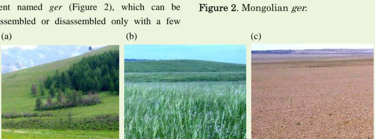
Most of Mongolian herders practisezed nomadic pastoralism. They live in the portable
tent named ger (Figure 2), which can be assembled or disassembled only with a few
hours. Pasture use system varies with the
climatic gradient. In humid area, land is customary owned and herders moves a few km seasonally. On the contrary, in arid area, land
tenure is almost open and they move sometimes more than 100 km to seek pasture where it rained.
Establishment of GCOE core sites
Study sites in Mongolia have been established
through the 21st Century Center of Excellence project “Biodiversity and Ecosystem Restoration” (FY2003-2008). We are to make
the most of the results and cooperation setup of the COE. We have been good academic relationships, such as exchange of researchers
and students and joint campaign of field research with the Center for Ecosystem Studies in Mongolian State University of Agriculture.
Asian Conservation Ecology
Newsletter Vol. 2, No. 2 May, 2010
(a) (b) (c)
Figure 1. Various ecosystem types in Mongolia. (a) Forest steppe, (b) typical steppe and (c) semi-desert steppe.
GCOE 2
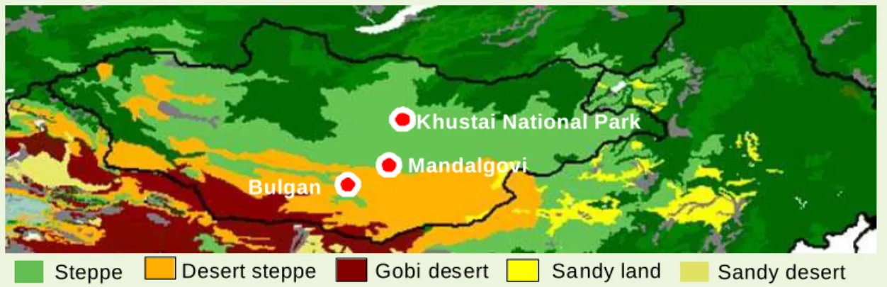
Introduction of core sites
We have three core sites in Mongolia along
climatic gradient (Figure 3).
1. Khustai National Park
This site contains Khustai National Park and
surrounding area. Annual average rainfall is around 250 mm. Ecosystem is a mixture of steppe and forest steppe, where forest exists
near the top of hills. This site is in typical desertified area, near to main loads to the capital city Ulanbator, where herders
concentrates for the convenience of market, education and medical facilities. On the contrary, grazing is prohibited in the Khustai
National Park, so there exists steep gradient of grazing intensities and resulting desertification or land degradation. Khustai National Park is
also a good study site for wildlife, as wild horse Tahi represents (Figure 4).
2. Mandalgovi
Mandalgovi city is located at the boundary of steppe and desert-steppe. Annual rainfall is
around 170 mm, but recently it rapidly decreases. Drought impact is significant in this region where there are no high mountains for
stable water supply. Moreover, herders concentrate around Mandalgovi city, the capital city of Dundgovi prefecture. Together with the
drought impact, herders can presently not practice the traditional seasonal pasture use. This especially threaten the livestock survival
in harsh winter, as well as the sustainability of rangeland ecosystem.
3. Bulgan
Our core site in Bulgan soum is located at the foot of Gobi-Altai Mountains. Annual average
ranfall is 120 mm, which classified arid area. This area is located in the series of sandy land (Figure 5), which is one of the primary source
of Asian dust which sometimes damage downward area including Japan. Countermeasures for Asian dust source is now
one of the major research topic. There exist climatic gradient from the foot to the top of mountains. Herders utilized such mixed
climatic area. Such pasture use across climatic area is now one of the important research topics for rangeland management.
Figure 4. Wild horse Tahi.
Figure 5. Sand mobilization
Steppe Desert steppe Gobi desert Sa ndy land Sandy desert
Khustai National Park Mandalgovi
Bulgan
GCOE 3
Research progress in Mongolian core sites
1. Identifying desertification benchmarks and indicators
We established sets of grazing exclusion fences in Mandalgovi and Bulgan sites to observe
restoration from various desertified level from grazing concentration points such as winter camps and water points (Figure 6).
We found ecological threshold exists along the gradient, over which vegetation composition drastically changes from perennial
grass to annual forbs which is not palatable for most livestock. Mongolian desertification was characterized such herbaceous vegetation
change, different from the desertification indicators developed in other regions in the world, such as decrease in vegetation amount
and shrub invation.
We also identified the vegetation change before thresholding process occur, which can
be utilized as the indicator species for local rangeland managers.
Figure 6. Design of field restoration experiment in Mandalgovi.
2. Remote sensing of desertification through herbaceous vegetation change and predicting restoration
Contrary to locality of desertification process, it emerges for large scale. Detecting herbaceous change was difficult and costly task for
operational desertification monitoring. We developed remotely-sensed desertification
monitoring method by use of standard (not high-performance) satellite censors, focusing
spatial heterogeneity of vegetation and soil in desertified area.
Combining the results from field survey and remotely-sensed desertification map, we
simulated the spatially-explicit desertification restoration under various counteraction scenarios (Figure 7).
10 years 20 years 30 years 40 years 50 years Figure 7. Example of restoration simulations.
Research prospects
Recent desertification studies focuses on the
tight spatially-explicit coupling of climatic fluctuations, herders’ pasture use and desertification. In arid environment, rainfall is
highly heterogeneous spatially and temporally. Vegetation responses to such heterogeneity, but the responses differ with vegetation types.
Herders utilized such difference of responses to survive harsh climate. Such pasture use then provides heterogeneous impact on vegetation.
Development interventions by international agencies in arid African rangeland until 80s failed because of lack of the understanding of
such environment, which causes desertification and poverty. Understanding of such dynamic rangeland ecosystem is a research topic named
“non-equilibrium range ecology.” In spite of active studies, the favorable rangeland management strategy in non-equilibrium
rangeland has still been in debate. We challenge this topic in Mongolia, by combining various socio-economic and ecological theories and
surveys for sustainable non-equilibrial rangeland management under changing surrounding environment.