Southeast Asian Studies, Vol. 28, No.2, September 1990
Coastal Geomorphic Response to Future Sea-level Rise
and Its Implication for the Low-lying Areas
of Bangkok Metropolis
SOMBOONJ.
R. P.*Abstract
Evidences on the relative sea-level rise in a tidal mangrove areas of this shoreline are useful to compile the measured and assumed rates of sea-level rise over the land for predicted conditions in the future and to compare the charts indicating the movements of the local sea-level change in the historical trend. In the low-lying areas of Bangkok Metropolis, an increase in sea-level of at least 1 m is accepted for the next 100 years due to the warming effect of present super-interglacial. The most serious current problem of Bangkok now is related to the excessive exploitation of groundwater which has resulted in wide-scale subsidence and groundwater contamination. In the Bangkok metropolis areas, a combination of subsidence and sea-level rise will seriously affect residential area, pollution of surface water and groundwater, flooding, wastewater drainage and treatment, agricultural land, and industrial and commercial activities in the foreseeable future.
Introduction
This paper aims to put coastal studies into the context of sea-level variations, especially where there is a direct bearing on shoreline
changes. The position of the shoreline in
coastal lowlands is dominated by the influx of sediments by rivers, tectonic movements and
sea-level changes. During the Quaternary,
the last-mentioned factor played an important role, i.e., eustatic sea-level changes of more than 100 m occurred as a result of the alter-nating glacial and interglacial periods. From 18,000 B.P. until about 6,000 B.P., the shift of the shoreline is dominated by the restoration of ocean level due to the melting down of land ice caps. During this period the shoreline of
*
Department of Geology, Chulalongkom University, Bangkok 10330, Thailandthe coastal lowland moved landward. Mter
6,000 B.P. the position of shoreline was dominated by tectonics, geoid changes, and to
a lesser degree, to glacial eustasy. This
resulted in the alternate advance and retreat of the shoreline in the overall process of pro-gradation of coastal areas.
In historical time, the position of shorelines has been influenced by human activities. Cut-ting down the forest in the catchment area of rivers results in a high amount of sediment in-flux into coastal areas. Examples are the pro-grading shoreline in Java, Indonesia, the arisen of the Po delta in Italy, and the Ebro delta in Spain []elgersma 1988b]. The con-struction of dams and reservoirs in rivers for
power generation and irrigation greatly
reduces the sediment supply to the shoreline, and this may result in a serious shoreline
lowlands of the world are experiencing damage from erosion, partly as a consequence of a small sea-level rise, but mostly due to
human activities. There is now a clear
evidence that human activities affect the shoreline change, not only at the regional level but also on a global scale. Tide gauges indicate that sea-level has risen between 10 and 15 cm during the last century [Barth and
Titus 1984; Jelgersma 1988a; Carter
1988; Hendry 1988; Charney 1979]. This
rise, greater than in the recent geological past, is thought to be caused by global warm-ing due to the increase of carbon dioxide and certain trace gases in the atmosphere, the "greenhouse effect." Itis estimated that the temperature will rise between 1.5 and 4°C in the coming 100 years due to this greenhouse
effect [Charney 1979]. The associated rise
of sea-level is estimated at between 0.50 and
1.50 meters. At the present time most
coastal lowland is already in a critical balance
with sea-level change. Accordingly, an
ac-celerated rise of sea-level in the coming cen-tury will have a profound and widespread im-pact on the social and economic conditions of coastal lowland areas. The following discus-sion examines the geomorphic effects of the projected sea-level rise on the low-lying coastal landforms of the Chao Phraya delta.
Geology and Morphological Changes of the Chao Phraya Delta
The Chao Phraya basin in Southeast Asia, remarkable for its tropical delta, is also a
storehouse of fascinating and complex
paleotectonic, paleoenviromental and
paleogeographical records of deposition over
a long geological period [Emery and Niino
1963; Achalabhuti 1975; Bunopas 1981;
Nutalaya and Rau 1983; Somboon 1988;
1990]. The Quaternary and Tertiary
sediments represent a complex sequence more than 2,000 m thick, of which only the up-permost 200 m is well known. Sedimentation was controlled throughout most of Tertiary and Quaternary time by a combination of tec-tonic movements both within the plain and in the adjacent mountains. The plain is situated over a large structural depression that has been filled with an assortment of clastic sediments, chiefly of clay to medium grain
size. The north-trending axis of the Chao
Phraya depression is related to the north-south structural trend of the Paleozoic and Mesozoic fold belt of western Thailand. The sediments reach a thickness of at least 1,859
m at a site 15kIn west of Bangkok, where a
borehole reached upper Cretaceous granite. Thirteen other deep boreholes have been drilled in the lower central plain but few have penetrated bedrock. The data suggests that the Chao Phraya trough has been tectonically active during most of Tertiary and Quater-nary times, receiving alluvial and deltaic sediments when the adjacent ranges were uplifted [Nutalaya and Rau 1983].
A Holocene sedimentological model for the Chao Phraya delta is summarized by
Som-boon [1990]. This model infers an initial
northerly prograding tidal-estuarine delta that deposited the marine clay, overlain by coastal and deltaic plain. The delta results from pro-gradation of a prism-like terrestrially derived sediment into the Holocene marine basin. In general, a tidal-estuarine delta system com-prises a number of individual deltas from the
GEOMORPHOLOGY
,,;
EXPLANATION
SI
TIDAL ZONE, E!I
BRACKISH SWAMP ZONE...
,.~iii
DeLTA PLAIN(MARINE CLAY)- 0
FLOODPLAIN..:. ~ DELTA PLAIN(BRACKISH CLAY)
II
LOWER TERRACEm
FAN DELTAB
OLD AllUVIAL FAN~ MIDDLE TERRACE
[J HIGH TERRACE
II
PENEPLAINQJ
TERRACE OF MARL • MOUNTAIN AND HILLS OFLOWER CENTRAL THAILAND
GULF OF THAILAND o
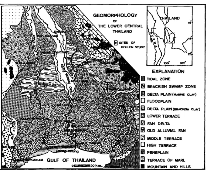
Fig. 1 Geomorphology of the Chao Phraya Delta, Thailand
rivers feeding the basin that have coalesced
laterally and/or undergone progradation.
This configuration of laterally interfingering alluvial systems results in a sedimentary body with a more regular rectangular distribution of facies than is seen in isolated deltas. The
morphology of deltaic plain changes in
response to the incidence of sediment-laden floodwaters which promote vertical accretion, particularly on channel margins; to the effects of the vegetation which colonizes the deposi-tional terrain; and to the extent of continuing subsidence, due to compaction of underlying
sediments or neotectonic movement. The
present feature of the Chao Phraya delta is classified into 13 units of landform in Fig. 1.
The Present Super-interglacial Period On the basis of definition, the present
in-terglacial age (the Holocene Epoch) began
about 10,000 years ago. Ananalysis of
deep-sea cores shows that no Pleistocene in-terglacial has lasted more than about 12,000 years and that most have lifespans of about 10,000 years [Ericsonet ai. 1956; Ericson and
Wollin 1968]. Climatic changes of the
LONG-TERM 10,000 YEARS 10 CLIMATIC OPTIMUM t 8 6 4
THOUSANDS OF YEARS AGO
MEDIUM-TERM 1.000 YEARS 2 LITTLE ICE AGE o a: LIJ ~ a:
;
a: w c oJ o UT
1.5 ·C1
LITTLE ICE AGE Less glacial 900SHORT - TERM 100 YEARS
1100 1300 1500 1700 YEAR A.D.
..
'
u • - ...4""
CI Z •. 2 C :J: U 0 w a: :;) I- ·.2 C a: W Q. -.4 2 WI--.'
.110 YEAR A.D.Fig. 2 Climatic Changes on Different Time Scale of the Present Interglacial Period (Adapted from Lamb [1969], Mitchell [1977a] and Imbrie,J.and Imbrie, K. P. [1986])
in global temperature, as estimated from geological records of mountain glaciers and fossil plants. One such trend is the long-term warming that began at 10,000 years ago and continued until at the postglacial climatic optimum of about 7,000 years ago, when temperatures were about 2°C warmer than
today, and rainfall was also greater. Since
then, the average temperature has been
gradually declining (Long-term trend). As
discussed further below, short episodes of warming and cooling known as the Little Ice Age cycle have been superimposed on this general cooling trend (Medium-term trend). The net result has been a 2°e lowering of the average global temperature. The clearest in-dication of this trend are changes in the
geographic ranges of animals and plants. In
the Short-term trend by averaging ther-mometer readings made at a worldwide net-work of weather stations, Mitchell [1977a] was able to show that global climate has been
cooling since 1940. Since 1939, average
temperatures of the northern hemisphere have declined about a.6°e.
Statistically speaking, the present
in-terglacial is already on its last legs, tottering along at the advanced age of 10,000, and can be expected to end within the next 2,000
years. Climatic forecast of the next 25,000
years is shown in Fig. 3. According to the
astronomical theory of the ice ages, the natural course of future climate (shown by the dashed line) would be a cooling trend leading to full glacial conditions, 23,000 years from now [Croll 1867a; 1867b; Van den Heuvel
1966; Broecker
et at.
1968; Mesolellaet at.
1969; Vernekar 1972; Hays
etat.
1976;Im-brie,
J.
and Imbrie,J.
Z. 1980; Imbrie,J.
andImbrie, K. P. 1986]. Although many human
activities influence climate (for example, agriculture, irrigation, forest cutting, ur-banization, and accompanying discharges of heat and smoke), by far, the greatest impact
-25 CARBON DIOXIDE INDUCED I ISUPE!' -INTERGLACIAL· w ~ 65 ~ ~ a:: w a. ~ 60 w ~
...
~ ~ 55...
"
z• ~ w 50 ~ ...-....l...~..._;.;""";~...~_...:.a...&&.;&1-1...,,...u.__..u-.u..lr...:o..._ _- - J...
o-THOUSANDS OF YEARS AGO Fig. 3 Climatic Forecast of the Next 25,000 Years
The industrial man continues his ever·growing consumption of energy and in the process adds further pollu-tion to the global atmosphere. Itwould plunge the planet into a "Super-interglacial age." (Modified from Broecker [1975] and Mitchell [1977b])
on climate comes from the burning of fossil fuels and the accompanying production of car-bon dioxide gas. This pollutant is an in-evitable product of combustion of all hydrocar-bon fuels, including coal, oil, natural gas, and a variety of lesser fuels. Since atmospheric carbon dioxide acts as a thermal blanket, the warming effect of burning fossil fuels may well interpose a "super-interglacial, " with global mean temperatures reaching levels several degrees higher than those experi-enced at any time in the last million years. In that case, onset of a cooling trend leading to the next ice age would be delayed until the warming had run its course, perhaps 2,000 years from now.
A Future Sea-level Rise
During the past half-decade, many con-ferences have been devoted to the amount and the impacts of a future sea-level rise. The first was an international conference on the assessment of the role of carbon dioxide and other greenhouse gasses in climate variation and their associated impacts, held at Villach, Austria, in October 1985 (By UNEP, ISCUS and WMO). The second was an international conference on the health and environmental effects of changes in stratospheric ozone and global climate, organized by the US. En-vironmental Protection Agency and UNEP in June 1986 at Crystal City, U.S.A.; which also included a workshop on sea-level rise. In August 1986, the Delft Hydraulics Laboratory organized an international workshop in the Netherlands on the impact of sea-level rise on the society. Recently, in September 1989, the International Geological Correlation
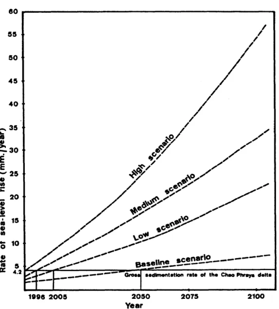
Pro-gram (IGCP 274) organized an international symposium on coastal evolution, management and exploration in Southeast Asia held in Ipoh, Malaysia. Concerning the future sea-level rise, the more forward-looking assessments have been published by the US. Environmental Protection Agency [Hoffman et al. 1983; Hoffman 1984; Barth and Titus 1984]. The Agency has attempted a realistic summary of the cause of sea-level rise, and considered possible tactics to offset the consequences. Projected global warming could cause the global average sea-level to rise 10-20 cm by 2025 and 50-200 cm by 2100. Hoffman [1984] presented a range of sea-level rise estimates, termed scenarios, that were developed on the basis of knowledge collected from a variety of disciplines, including energy economics, geochemistry, biology, atmospheric physics, oceanography, and glaciology. The most restrictive assumptions from these disciplines were linked together to generate a "baseline" scenario, which projects a sea-level rise of 56.2 cm by 2100. The least restrictive assumptions were used to generate a "high" scenario, which projects a rise of 345 cm by 2100. Two mid-range scenarios were also developed: a low scenario which projects a rise of 144 cm and medium scenario which projects a rise of 216 cm. In order to use these projected rises in sea-level to predict the coastal geomorphic response in the areas of Chao Phraya delta, it is neccessary to derive the estimated rate of sea-level rise by the scenario of Hoffman [1984] which can be com-pared with the actual sedimentation rate of the present coastline. The estimated rate of sea-level rise (mm/year), in 1990-2100, based
80 55 50 45 40 ,.... 35 ~
..
4.J ~30E
E - 2 5 u 4fta:
'i 20.i
• 15•
u ell...
0 10 u...
•
5 0:: 4.2~~
-'- _--- Oro..
.edlmentetlon rate of the ChMPhr-ra delta~~--~.
2100 2075
1888 2005 2050
Yeer
Fig. 4 Estimated Rate of Sea-level Rise, 1990-2100, by Scenario (mm/year), Togetherwiththe Gross Sedimentation Rate of the Chao Phraya Delta (mm/year)
on the scenario of Hoffman [1984], together with the gross sedimentation rate of the Chao Phraya delta (mm/year), is shown in Fig. 4.
Projected Sea-level Rise for the Chao Phraya Delta
This discussion describes the geomorphic effects of the projected sea-level rise on low-lying coastal landforms of the Chao Phraya
delta. Two categories of physical response
are addressed: shoreline changes representing
landward displacement of the land/water inter-face, and groundwater changes resulting from saltwater intrusion into coastal aquifers. The position of the shoreline in coastal lowlands is dominated by the influx of sediments from upland sources (the sedimentation rate), tec-tonic movements, and the sea-level changes. Sedimentation rates and tectonic movement of the Chao Phraya delta have been of the same order of magnitude as during the Holocene. Changing sea-level is probably the
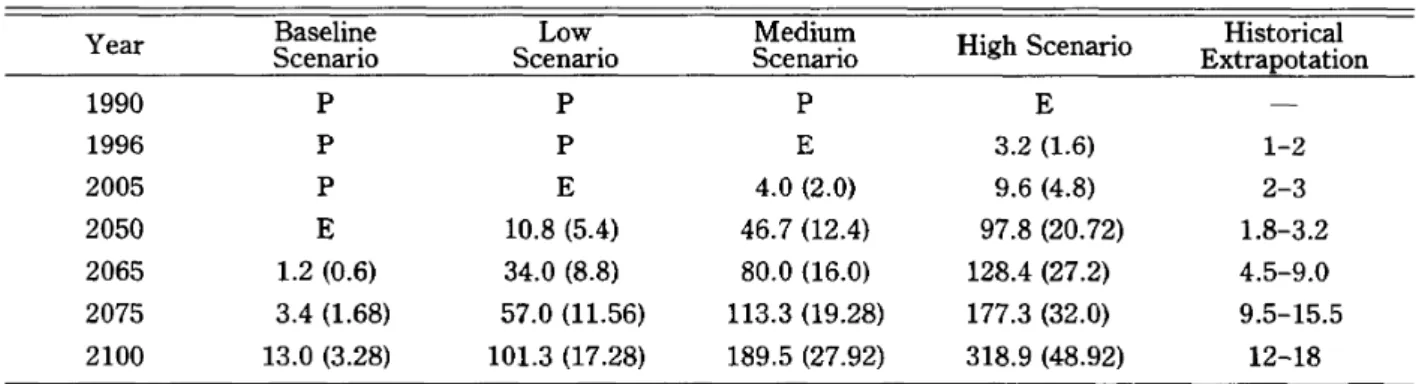
Table 1 Year 1990 1996 2005 2050 2065 2075 2100
Predicted Conditions of the Chao Phraya Delta by the Year 1990-2100 after Sea-level Rise
Baseline Low Medium High Scenario Historical
Scenario Scenario Scenario Extrapotation
P P P E P P E 3.2 (1.6) 1-2 P E 4.0 (2.0) 9.6 (4.8) 2-3 E 10.8 (5.4) 46.7 (12.4) 97.8 (20.72) 1.8-3.2 1.2 (0.6) 34.0 (8.8) 80.0 (16.0) 128.4 (27.2) 4.5-9.0 3.4 (1.68) 57.0 (11.56) 113.3 (19.28) 177.3 (32.0) 9.5-15.5 13.0 (3.28) 101.3 (17.28) 189.5 (27.92) 318.9 (48.92) 12-18 P=Progradation of the coastal plain
E=Equilibrium stage or erosion of the coastal plain
Note: Sea-level rise over the land is given in centimeters with the rate of sea-level rise over the land in parenthesis (mm/year).
major factor determining coastal evolution. The coastal geomorphic response to sea-level conditions can be recognized as: rising (trans-gression of the sea over the land or erosional shoreline); falling (regression of the sea or progradational shoreline); and stationary (equilibrium). The rising and falling stages are ones of massive sediment release and transport, while the stationary stage allows time for adjustment and reorganization towards equilibrium. Throughout the ensu-ing discussion, it must be borne in mind that sediment availability as well as sea-level fluc-tuation exercise a strong control over changes in coastal forms.
Studies of sea-level over the last two cen-turies show that the average sea-level has been rising at a rate of 1-1.2 mm/year [Bruun 1962; Fairbridge 1966]. It is postulated that a local stationary stage of sea-level would have occurred when the rate of sea-level rise equalled the gross sedimentation rate. Gross sedimentation rate of the present Chao Phraya delta is therefore given by: Gross sedimentation rate
=
Net sedimentation rate+
present rate of sea-level rise+
basinsub-sidence.
The net sedimentation rate can be calculated if the rate of delta advance and the delta slope are known. As the advance of the Chao Phraya deltaic plain is 4-5 meters/year and the deltaic slope is 0.05% [NEDECO 1965], the net sedimentation rate is calculated at 2-2.5 mm/year. Subsidence in contem-porary sedimentation basins or geosynclines is fairly low, at 0.1 mm/year, whereas deltaic basins have larger subsidence rates due to higher sedimentation rates and the secondary consolidation of the more compressible sediments in the surface layers. The sub-sidence rate of the Chao Phraya delta is 0.5 mm/year as calculated from the basal peat of age around 6,000 year at 3 m depth below the present sea-level. Itwould appear that trans-gression of the sea over the present deltaic areas may occur when the future rate of sea-level rise equals or exceeds the gross sedimen-tation rate of 4.2 mm/year. In Fig. 4, it is useful to compare the measured and assumed rates of sea-level rise over the land for predicted conditions of the Chao Phraya delta areas after the sea-level rise. More
specifi-cally, Table 1 gives a long-term projections of the relative rise of the sea-level for the Chao Phraya delta by the year 2100.
A Preliminary Assessment for the Bangkok Metropolis
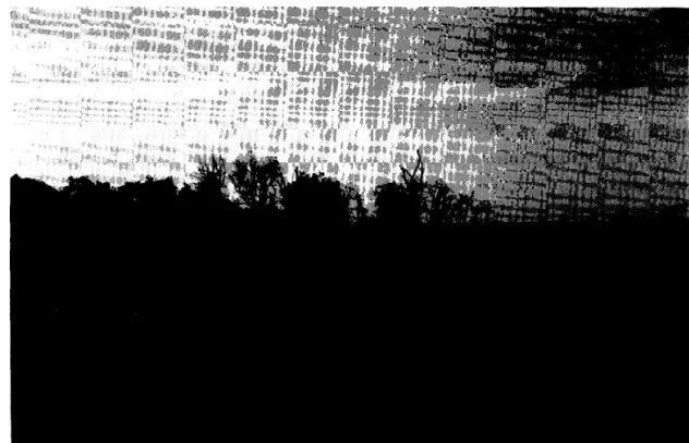
Experience in mangrove areas of the Chao Phraya delta points to the physical effects of a significant rise in sea-level on this shoreline. Mangrove development in the Chao Phraya delta generally have slowed down, and in places stopped due to the killing of the mangrove trees (Fig. 5), as the local sea-level rose to the equilibrium stage. In the author's opinion, the future sea-level rise for the Chao Phraya delta is most likely to fall in the medium scenario or at least in the low scenario (Table. 1). If the sea-level rises at
the rate predicted by the medium scenario, the projected rise in sea-level will lead to coast
erosion and redistribution of sediments,
wetland submergence, floodplain water-log-ging and salt intrusion into coastal aquifers.
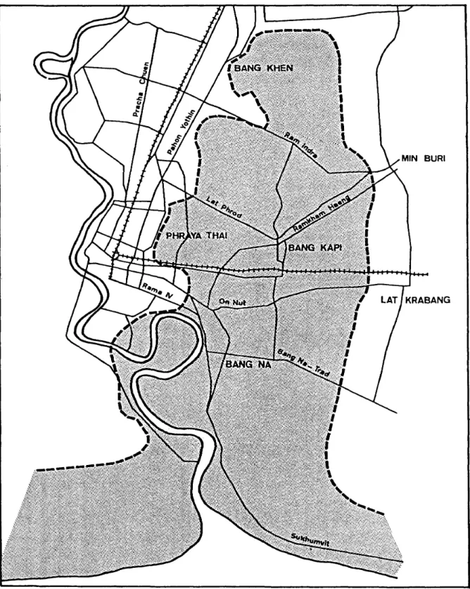
For the Bangkok metropolis, the most serious current problem is related to an ex-cessive exploitation of groundwater, which has resulted in wide-scale subsidence and
groundwater contamination. The high level
of pumpage of groundwater from intercon-nected sands in eastern Bangkok has resulted in the lowering of ground surface and develop-ment of a major subsidence bowl (Fig. 6). This bowl is very shallow, with an average depth of less than 0.5 m, but it covers an ex-tensive area of the eastern suburbs. The area encompassed by the 10 em/year subsidence contour includes about 250 sq km of eastern
Fig. 5 Local Sea-level Rise to near the Equilibrium Stage from the Evidence of Slow Down or Stopping of Mangrove Development (At the shoreline of Wat Asokaram, Southwest of Samut Prakhan)
[±l
EEl
k:::::\::1
MId
~ ISOSUBSIDENCE CO~ITOUR(CENTIMETRES PER YEAR) LAND SURFACE CONTOUR (ME TRES ABOVE SEA LEVEL) AREA FLOODED HEAVILY IN 1983
ACTIVE TIDAL fLAT
AREA OF BANGKOK WITH ALTITUDE LESS THAN , MEfRE A80VE SEA LEVEL
AREA WITH ALTITUDE LESS THAN 0.5 METRE ABOVE SEA LEVEL AREA WITH ALTITUDE
BELOW SEA LEVEL
AREA OF POTENTIAL fLOODING POSSIBLE RECHARGE PIT (SAND QUARRY AT SENANIVET) FL.OOD CONTROL DIKE
Bangkok. The area shown on Fig. 6 is also prone to more severe flooding as water drains more slowly through its natural drainage and man-made canal systems. All of these canals drain west to the river and must climb the western lip of this bowl before discharging into the Chao Phraya river. The major effect of the 1983 flood was felt precisely within the most rapidly subsiding area of the city, with the most serious flooding occurring in the
lowest topography. Recent predictions
in-dicate that parts of this area would be below sea-level by the year 2000 if present ground-water pumpage rates continue unabated. For the future of Bangkok metropolis, a combina-tion of subsidence, due to over exploitacombina-tion of groundwater, and a future sea-level rise will
seriously affect residential, industrial,
economic and commercial activities, and agricultural land.
Determination of Shoreline Change
Two different approaches can be used to model shoreline reconfiguration in response to
sea-level rise. The Bruun rule describes the
equilibrium profile achieved after material removed during shoreline retreat is transfer-red onto the adjacent shoreface/inner shelf [Bruun 1962; Weggel 1979; Schwartz and
Fisher 1979]. The second approach is less
sophisticated for modeling purposes but more realistic in a geomorphic sense; it involves the empirical determination of new shorelines
us-ing trend lines. In this case, shoreline
response is correlated to the historical trend with respect to the local sea-level changes
dur-ing that time period. This procedure
ac-counts for the inherent variability in shoreline response based on differing coastal processes,
sedimentary environments, and coastline ex-posures.
One of the sources of historic information is the charts of the Chao Phraya river and the shoreline, kept in the archives of several coun-tries outside Thailand, Great Britain, France and the Netherlands, and dated back to the
17th Century. These were made after
surveys carried out by missionaries, naval par-ties and merchants trading with Thailand
(Siam) in those days [NEDECO 1965].
Reproductions of charts made of the shoreline area are shown in Fig. 7, the oldest one drawn around 1650. Some indications can be
obtain-ed from these charts regarding the
topographic changes which took place in the
respective years. The chart of 1856, for
ex-ample, made from a survey carried out by one Capt. Richards of the Royal Navy, states that "the depths of sea bottom are given in meters
below low water of April" [NEDECO
1965]. The datum of the chart is, therefore,
not very closely defined, and the exact difference between low water in April 1856
and M.S.L. in1960 is not known, but must be
estimated in order to make a comparison of both charts possible.
The chart of 1797 shows the last few kilometers of the Chao Phraya delta and the
river-mouth areas. Starting-point for a
com-parison with later situations is the bendinthe river, drawn at the top of this chart, which ap-pears to be the same as is now to be found just
north of Paknam. The direction of the
en-trance of the Chao Phraya river in 1797 was south-south-west, the same as the present direction of the river just below Paknam. Comparison of the 1797 chart with the next one, made in 1856, seems to suggest that in
the intervening period of nearly 60 years, the shoreline shifted about 4kIn to the south, or
at an average rate of about 70 m per year.
Comparing the charts of 1856 and 1960, however, it appears that in the past hundred years or so, the eastern shoreline has practi-cally kept its place, while the western shore adjacent to the river-mouth has grown in a southeastern direction over a distance of ap-proximately half a kilometer, at an average
rate of only about 5 m per year. This
ap-parent considerable change in accretion rate is rather strange. A sudden changeinthe ac-cretion rate as is suggested by the charts of 1797, 1856 and 1960 can be confirmed of the
trend of sea-level rise dating back to the 18th century. It is true that in the course of cen-turies the growth of delta may gradually slow down as the local sea-level of this shore has been rising for the past few hundred years. In the final stages of delta formation, an equilibrium may even be attained in the near future.
The future positions of shoreline can be plot-ted by manual interpolation between the ex-isting altitude (Fig. 8), recent man-made rate of land subsidence, and minimal projected rate of sea-level rise (at the low scenario for this area). The next step is to adjust and to correlate shoreline positions based on
geomor-1650
.
/ • i . : i • i .-,' I 0 1 2 3 4 5 k m 1797 •... km ...•.....
1856 ..-.... 0 1 2 3 4 5 k r n . . ... .... o1 2 3 4 5 km .... -,..-.. . . ... . . ...~ .. . . . .r • • _ -... 0 1 2 3 . 5 k m '.H._ .Fig. 7 Historical Shoreline Changes of the Chao Phraya River-mouth Areas, 1650-1960 (After NEDECO[1965])
phic approaches, such as historical trends of erosion and accretion, coastal processes,
sedimentary environments, and coastline
equilibrium exposures (by the Bruun rule). The Fig. 9 shows the area of the Bangkok metropolis which can be covered by sea-water
The boundaries and names shown on this mapdonot imply official acceptance or endorsement by the United Nations
GROUND ELEVATION (mITres abovi mlon SIO IIVII)
1.0 - 2.0
..
0.6 -0.9..
0-0.5 o, 2 S 4 5 KM.; ! '==I
Fig. 8
SCALE
Map Showing Recent Altitude in Meters above Mean Sea Level of Parts of Bangkok Metropolis (After ]leA [1984])
Fig. 9 A Minimal Projected Shoreline Changes of the Chao Phraya River-mouth Areas in the Year 2100, by the assumption: 1) Sea-level rise will fall at least in the low scenario; 2) Groundwater pumpage and subsidence rate will continue unabated; 3) No protection strategy will be con-structed.
by the year 2100, if the rate of sea-level rise falls in the low scenario and groundwater pum-page rates continue unabated from their 1984 levels. In all foreseeable circumstances, sea level is likely to rise with the amounts con-siderably greater than the rise of this past
cen-tury. In order to improve substantially the
estimates of future sea-level rise in the areas of Bangkok metropolis, more time and more
scientific research will be needed. Merely
waiting for observations will be the slowest way to learn more about sea-level's future rise. To maximize the value of future obser-vations, the theoretical base and models used to interpret the relevant data must be
im-proved. Rapid progress can be made by
ac-celerating the research aims at improving our basic understanding of the process.
Conclusions and Recommendations The geomorphology of Bangkok metropolis has been largely ignored in the planning and
development of the city. Decision-makers
need to have some basis for establishing priorities when faced with the question of selecting suitable areas for development, especially if parts of the municipality are faced with either natural or man-induced
hazards. Of the technical constraints to the
urban development of Bangkok, the most serious current problems are related to the future sea-level rise and the excessive ex-ploitation of groundwater which has resulted in wide-scale subsidence and groundwater con-tamination. An increase in sea-level rise of at
least 1-1.5m is accepted for the next 100
years, and an increase in flooding and storm, especially severe tropical storms can not be
ex-cluded as a result of the increase of world temperature and its effect on lowlands. Like the physical effects of sea-level rise, the en-vironmental impacts will create a problem for the growth of the city as the pollution of sur-face water, wastewater drainage and treat-ment, water supply (good quality), etc. were generated by increased population, and the
sea level became a serious problem. The
following are conclusions and recommenda-tions concerning all of the coastal lowland of the Bangkok metropolis:
1. Observe tide gauge measurements; if no
tide gauges are available they shouldbe con-structed.
2. Make an infrastructure to control
man-induced subsidence caused by groundwater
and drainage. An important evaluation
should take place before planning new urban coastal settlements.
3. Map and measure coastal erosion and
ag-gradation.
4. Make "Coastal Hazard Maps".related to the increased rise of sea-level and changes in
storminess. Indicate areas in extreme risk,
high risk and moderate risk.
5. A database should be developed for the collation, storage and retrieval of relevant
geologic, hydrologic, geohydrologic and
engineering information.
How can the areas of Bangkok metropolis respond to the predicted rise in sea-level?
They can either try to defend the Bangkok
areas or to move present activities and
development to suitable places. The
protec-tion can be done by dykes, sea walls, and other engineering solutions. Itmust be real-ised that economic and environmental im-pacts can make such a protection strategy
unacceptable. Also, moving present ac-tivitieswillhave a serious economic and social effect to the city. City planners will have to do more long-term studies to solve the foreseeable problems.
Acknowledgements
My deep appreciation to my advisor, Prof. Yoshikazu Takaya, who was a great catalyst of scientific logic for me. His enthusiasm, width and warmth were transmit-ted to me throughout my study in Japan. I am grateful to the following persons for their helpful comments on the manuscript: Dr N. Thiramongkol, Dr H. Furukawa, Dr S. Nitungkorn, Acharn C. Manipluksa and Acharn Achara Jaiyagam.
References
Achalabhuti, C. 1975. Petroleum Geology of the Gulf of Thailand. Economic Geology
Bulletin 7. Department of Mineral Resources,
Bangkok.
Barth, M. C.; and Titus, J.G., eds. 1984. Greenhouse
Effect and Sea-level Rise. New York: Van
Nostrand Rheinhold.
Broecker, W. S.;Thurber, D.L.;Goddard,J.; Ku, T.; Matthews, R.K; and Mesolella, K J. 1968. Milankovitch Hypothesis Supported by Precise Dating of Coral Reefs and Deep-sea Sediments.
Science 159: 1-4.
Broecker, W. S. 1975. Climatic Change: Are We on the Brink of a Pronounced Global Warming?
Science 189: 460-463.
Bruun, P. 1962. Sea-level Rise as a Cause of Shore Erosion. Journal of Watenvays and Harbours
Divi-sion, ASCE 88(ww1): 117.
Bunopas, S. 1981. Paleogeographic History of Western
Thailand and Adjacent Parts of Southeast Asia: A Plate Tectonics Interpretation. (Geological Survey
Paper No.5). Department of Mineral Resources, Bangkok.
Carter, R.W. G. 1988. Coastal Environments: An In-troduction to the Physical, Ecological and Cultural
Systems of Coastlines. Academic Press.
Charney, J. F. (chairman; Climatic Research Board).
1979. Carbon Dioxide and Climate: A Scientific
Assessment. Washington D.C.: NAS Press.
Crawfurd,J.1828. Journal of an Embassy to the Courts
of Siam and Coc/in China. Oxford University
Press. (Reprint ed., Kuala Lumper, 1967.)
Croll,J. 1867a. On the Excentricity of the Earth's Or-bit, and Its Physical Relations to the Glacial Epoch. Philosophical Magazine 33: 119-131. _ _ _. 1867b. On the Change in the Obliquity of
the Eliptic, Its Influence on the Climate of the Polar Regions and on the Level of the Sea.
Philosophical Magazine 33: 426-445.
Emery, K 0.; and Niino, H. 1963. Sediments of the Gulf of Thailand and Adjacent Continental Shelf.
Geol. Soc. American Bull 74: 541-544.
Ericson, D. B.; Broecker, W. S.; Kulp, J.L.; and Wollin, G. 1956. Late-Pleistocene Climates and Deep-sea Sediments. Science 124: 385-389. Ericson, D.B.; and Wollin, G. 1968. Pleistocene
Climates and Chronology in Deep-sea Sediments.
Science 162: 1227-1234.
ESCAP Secretariat. 1988. Geological Information for Planning in Bangkok, Thailand. In Geology and
Urban Development: Atlas of Urban Geology VoLl,
pp. 24-60. ESCAP, United Nations.
Fairbridge, R.W. 1966. Mean Sea-level Changes, Longterm, Eustatic and Others. In Encyclopedia
of Oceanography, edited by R. W. Fairbridge.
Reihold Publishing Co.
Hays, ]. D.; Imbrie, ].; and Shackleton, N.]. 1976. Variations in the Earth's Orbit: Pacemaker of the Ice Ages. Science 194: 1121-1132.
Hendry, M. 1988. Implications of Future Sea-level Rise for Caribbean Shorelines. In Extended
Abstracts of International Symposium on
Theoretical and Applied Aspects of Coastal and Shelf Evolution, Past and Future, 19-24 September
1988, Amsterdam (By Roy. Neth. Acad.
Sci/IGCP), pp.37-39 (abstract).
Hoffman, J. S.; Keys, D.; and Titus, J. 1983. Projec-ting Future Sea-level Rise: Methodology, Estimates to the Years 2100 and Research Needs. 2nd. Rev.
ed. U.S.GPO. No.055-000-00236-3. Washington D.C.: Government Printing Office.
Hoffman, J.S. 1984. Estimates of Future Sea-level Rise. In Greenhouse Effect and Sea-level Rise, edited by M. C. Barth; and J. G. Titus, pp.79-103. New York: Van Nostrand Reinhold.
Imbrie, J.; and Imbrie, J.Z. 1980. Modeling the Climatic Response to Orbital Variations. Science
207: 943-953.
Imbrie, ].; and Imbrie, K P. 1986. Ice Ages: Solving the Mystery. England: Harvard University Press.
Jelgersma, S. 1988a. A Future Sea-level Rise: Its Im-pacts on Coastal Lowlands. In Geology and Urban
Development: Atlas of Urban Geology VoLl,
pp.61-81. ESCAP, United Nations.
_ _ _.1988b. The Swinging Shoreline: Past, Pres-ent and Future. In Extended Abstracts of
Aspects of Coastal and Shelf Evolution, Past and Future, 19-24 September 1988, Amsterdam (By
Roy. Neth. Acad. Sci./IGCP), pp.49-50 (abstract). I1CA (Japan International Cooperation Agency).
1984. Studies on Flood Protection/Drainage Project in Eastern Suburban-Bangkok. Preliminary Study.
_ _ _. 1985. Studies on Flood Protection/Drainage Project in Eastern Suburban-Bangkok. Masterplan
Study.
Jermias Van Vliet. 1910. Description of the Kingdom of
Siam. Translated by L. F. Van Ravenswaay. JSS7,
pt.1.
Lamb, H. H. 1969. Climatic Fluctuations. In World
Survey of Climatology 2; General Climatology,
edited by H. Flohn, pp.173-249. New York: Elsevier.
Mesolella, K.J.; Matthews, R. K.; Broecker, W. S.; and Thurber, D.L. 1969. The Astronomical Theory of Climatic Change: Barbados Data. Jour.
Geol. 77: 250-274.
Mitchell, J. M., Jr. 1977a. The Changing Climate. In
Energy and Climate, Studies in GeOPhysics, pp.
51-58. Washington: National Academy of Sciences. _ _ _ _. 1977b. Carbon Dioxide and Future
Climate. In Environmental Data Service, March, pp.3-9. US. Dept. Comm.
Moreland W. H., ed. 1934. Peter Floris: His Voyage to
the East Indies in the Globe, 1611-1651. London.
Nicholas Gervaise. 1689. The Natural and Political History of the Kingdom of Siam. (Translated by H.
S. O'Neill, 1928). Bangkok.
NEDECO (the Netherlands Engineering Consultants).
1965. Siltation: Bangkok Port Channel. Vo1.2.
Report to the Government of Thailand.
Nutalaya, P.; and Rau, J. L. 1983. Geomorphology and Land Subsidence in Bangkok, Thailand. In
Guidebook for Field Trip Itinerary in the Short Course on Applied Quaternary Geology, edited by P.
Nutalaya,pp. 181-202. Bangkok:AIT.
Pallegoix, J. B. 1854. Description du Royaume Thai ou
Siam. Vol.1. Gregg International Publishers.
(Reprint ed., Farnborough, England, 1969.) Schwartz, M. L.; and Fisher]. J., eds. 1979.
Pro-ceeding of the Per Bruun Symposium. Newport, R.
I.: IGU Commission on the Coastal Environment. Smyth, H. W. 1898. Five years in Siam from 1891 to
1896.Vol.1. London: John Murray.
Somboon, ]. R. P. 1988. Paleontological Study of the Recent Marine Sediments in the Lower Central Plain, Thailand. Journal of Southeast Asian Earth
Sciences 2(3/4): 201-210.
_ _ _.1990. Geomorphology of the Chao Phraya Delta, Thailand. Ph. D. dissertation, Kyoto University, Japan.
Somi, E.; and Morner, N-A. 1988. Sea-level Changes and Coastal Erosion in Tanzania. In Extended
Abstracts of International Symposium on
Theoretical and Applied Aspects of Coastal and Shelf Evolution, Past and Future, 19-24 September
1988, Amsterdam (By Roy. Neth. Acad.
ScilIGCP), pp.120-123 (abstract).
Van den Heuvel, E. P.J.1966. On the Precession as a Cause of Pleistocene Variations of the Atlantic Ocean Water Temperatures. GeoPhys.]. R. Astr. Soc. 11: 323-336.
Vemekar, A. D. 1972. Long-period Global Variations
of Incoming Solar Radiation. Meteorological
Monographs 12. Amer. Meteorol. Soc., Boston. Weggel, R. 1979. A Method for Estimation Long-Term
Rise in Water Level. CERC Technical Aid 79-2.
Fort Belvoir, Va.: Coastal Engineering Research Center.
Zhao, X. 1988. A Brief Introduction on the Project "Preliminary Study on Sea-level Changes in China and Their Trends and Impacts." In Extended
Abstracts of International Symposium on
Theoretical and Applied Aspects of Coastal and Shelf Evolution, Past and Future, 19-24 September
1988, Amsterdam (By Roy. Neth. Acad.
![Fig. 2 Climatic Changes on Different Time Scale of the Present Interglacial Period (Adapted from Lamb [1969], Mitchell [1977a] and Imbrie, J](https://thumb-ap.123doks.com/thumbv2/123deta/6761354.1692837/4.896.160.731.166.1066/climatic-changes-different-present-interglacial-period-adapted-mitchell.webp)
![Fig. 6 Map of Subsidence Bowl Showing the Rate of Subsidence and Other Constraints [ESCAP 1988]](https://thumb-ap.123doks.com/thumbv2/123deta/6761354.1692837/10.902.114.787.167.1097/fig-subsidence-bowl-showing-rate-subsidence-constraints-escap.webp)
![Fig. 7 Historical Shoreline Changes of the Chao Phraya River-mouth Areas, 1650-1960 (After NEDECO [1965])](https://thumb-ap.123doks.com/thumbv2/123deta/6761354.1692837/12.894.117.787.549.1091/historical-shoreline-changes-chao-phraya-river-areas-nedeco.webp)