18
ISSN: 2187-3666 (online)
DOI: http://dx.doi.org/10.14246/irspsd.4.2_18
Copyright@SPSD Press from 2010, SPSD Press, Kanazawa
A Registration System for Preventing/Mitigating Urban Flood Disasters as One Way to Smartly Adapt to Climate Change in Japanese Cities
Sampei Yamashita 1* , Sadanori Matsuda 1 , Ryoichi Watanabe 2 , Yukihiro Shimatani 3 , Toshiyuki Moriyama 4 , Hironori Hayashi 3 ,
Hiroki Iyooka 2 , Teruki Hamada 2 , Terukazu Yamashita 5 , Kumiko Kakudo 5 and Tomoko Minagawa 6
1 Department of Civil and Urban Design Engineering, Kyushu Sangyo University 2 Department of Civil Engineering, Fukuoka University
3 Department of Urban and Environmental Engineering, Kyushu University 4 Department of Socio-Environmental Studies, Fukuoka Institute of Technology 5 NPO Minamihata Dam Chosuisurukai
6 Department of Environmental Management and Planning, Kumamoto Univsersity
* Corresponding Author, Email: [email protected] Received 5 July, 2015; Accepted 11 November, 2015
Key words: Watershed management, Urban flooding, Rainwater retention, Smart adaptation
Abstract: Intensive rainfall and frequent inundation have become a serious problem in urban areas all over the world. Climate change and heat island effect may be the cause of the phenomena. Widespread impervious pavement/surface of the ground makes things worse. In order to promote an effective river basin management in urban areas and reduce runoff, a registration system called
“Safety Plan for 100mm/h-Rainfall” (“100mm/h Anshin Plan” in Japanese), a scheme for preventing and mitigating inundation caused by extremely heavy, short-term rainfall (such as 100mm/h-rainfall) was established in April 2013 by the central government in Japan. This study carried out a questionnaire survey to examine how municipalities effectively utilize the registration scheme for their watershed management. As a result, it is found that there are municipalities who have started/revised subsidizing installation of private rainwater retention/infiltration facilities in association with the registration system; however, municipalities in general are not so active in promoting runoff reduction by subsidizing private facilities. In addition, in the plans emphasizing public works for runoff reduction, public involvement is not so active, whereas in the plans devised with relatively new committees of watershed management, public involvement as well as private retention activities tend to be active. Based on the results, prospects of how a safety plan should be utilized in an urban watershed are discussed and examined from practicality’s point of view.
1. INTRODUCTION
Intensive rainfall and frequent inundation have become a serious problem
in urban areas all over the world. Climate change and heat island effect may
be the cause of the phenomena. Widespread impervious pavement/surface of
the ground makes things worse. Measures such as dredging rivers, increasing
the capacity of the rainwater drainage system and constructing flood walls
Yamashita et al.
are not always effective. It should be necessary for people to reduce direct runoff by retaining/infiltrating rainwater within the entire urban watershed as there are a number of private properties and enterprises situated there.
Harvesting the retained rainwater may contribute to recovering a sound hydrologic cycle in urban areas, which must be one way to smartly adapt to climate change.
In order to promote effective river basin management in urban areas and reduce runoff, a registration system called “Safety Plan for 100mm/h- Rainfall” (“100mm/h Anshin Plan” in Japanese), a scheme for preventing and mitigating inundation caused by extremely heavy, short-term rainfall (such as 100mm/h-rainfall) was established in April 2013 by the central government in Japan (MLIT (Ministry of Land, Infrastructure, Transport and Tourism), 2013).
A national policy for comprehensive flood control in the face of rapid urbanization in the city has been enforced since 1977 in Japan. The policy is focused not only on river-system/drainage management but also on surface- runoff reduction by retaining/infiltrating rainwater in the watershed.
However, the policy has been applied to only 17 rivers and their watersheds from 1977 up until 2015. 12 of them are managed directly by the central government; and thus, they tend to depend on the rainwater retention/infiltration function from public facilities and properties in spite of the policy’s emphasis on runoff reduction involving private-sector collaborations (Shimatani, Y., Yamashita, S. et al., 2010).
Moreover, storm-water management incorporating green infrastructure involving the private sector has been implemented, especially in recent years, in developed countries because of its cost effectiveness in maintenance (NYC Environmental Protection, 2014; Furumai, H., 2015);
this approach is critical in a society with population decline like Japan. The registration system of “Safety Plan for 100mm/h-Rainfall” was established in these circumstances.
This study is to get information directly from the municipalities that have their officially-registered schemes and to contribute to subsequent planning for flood control in other urban areas.
2. METHOD
2.1 The registration system
“Safety Plan for 100mm/h-Rainfall” was introduced in April 2013 by the Ministry of Land, Infrastructure, Transport and Tourism (MLIT). This has much to do with one of the policies the Japanese government has implemented to tackle flood disasters especially in urban areas in a comprehensive way since the late 1970s (MLIT, 2013). The plan is intended to mitigate food damage in urban areas not only by improving river channels and drainage systems but also by installing rainwater retention/infiltration facilities/functions all over the urban river basin. It expects river and drainage-system administrators, residents and private firms to collaborate and mitigate flood disasters by reducing surface runoff and sharing safety/risk information.
MLIT requires potential municipalities first to devise and implement the
legal river development project and storm-water drainage project and then to
incorporate the following three aspects into their safety plan:
IRSPSD International, Vol.4 No.2 (2016), 18-29
1) The target rainfall intensity must be greater, more local and shorter- lasting than the intensities set in both their legal river development project and storm-water drainage project.
2) River and drainage-system administrators, residents and private firms must work collaboratively and mitigate flood disasters by reducing surface runoff and sharing safety/risk information.
3) Measures focused on flood-damage reduction must be emphasized.
The first requirement implies a Safety Plan for 100mm/h-Rainfall is to cover what both the river development project and storm-water drainage project by the municipalities do not. That is why collaboration involving citizens/private firms and “flood-damage reduction” are emphasized in the second and third requirement, respectively. The registered municipality can get a grant from the central government and provide tax breaks/subsidies for those who install rainwater retention/infiltration facilities on their premises.
2.2 Questionnaire survey
A questionnaire survey was carried out to ask the registered local governments how they have planned and managed their rivers and watersheds. The questions included: 1) basic information such as urbanization rate, targeted rainfall intensity, etc., 2) watershed management measures, 3) damage mitigation measures, 4) relevant regulations, 5) public awareness, etc. (see Table 1, below). In this study, whether registering a plan is effective or not is judged by the disaster-mitigation measures newly implemented in association with the registration.
The questionnaires were sent by mail firstly on October 29, 2014 and secondly on May 7, 2015, and the responses were returned by November 19, 2014 and by May 27, 2015, respectively. The municipalities registered include the city of Nagoya and Kitakyushu, major cities/metropolises of Japan (population: 2.28 mil. and 0.96 mil., respectively), and 13 mid- to small-sized cities registered as of the end of October, 2015.
The outlines of the plans are open to the public (MLIT, 2014) and are referred to in the analysis of the survey results. The sewer/rainwater drainage system and relevant recent floods are also listed for reference (see Table 2).
Table 1. Outline of the questionnaire survey
Period Oct.15-Nov.19, 2014 and May 7-27, 2015
Items
・Basic information
(Urbanization rate, targeted rainfall, etc.)
・Watershed management
・Damage mitigation
・Public awareness
・Others
Format Structured & open-ended
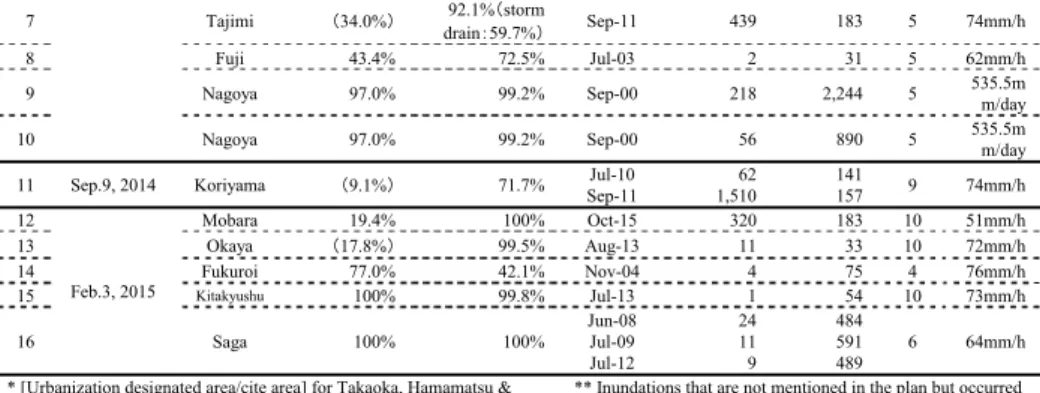
Table 2. Overview of the registered plans
No. Registration
date City
Urbanization rate in registered watershed*
Coverage of sewer/
rainwater drainage systems
Inundation referred to in the plan Period (yrs.)
Targeted rainfall intensity Mo.-Yr. Above 1st
floor level
Below 1st floor level
1
Sep.4, 2013
Takaoka
(17.3%)89.6% Jul-12
179 (cases) 348 (cases)10 67mm/h
2 Kanazawa 18.4% 97.5% Jul-08
**507 1,476 10 55mm/h
3 Numazu 24.0% 56.5% Jul-07 16 23 5 49mm/h
4 Yaizu 34.5% 22.5% Jun-04 57 58 5 88mm/h
5
Hamamatsu (6.3%)79.5% Sep-98 21 107
river:10/ drain: 773mm/h
6 Feb.4, 2014 Kanuma 29.5% 60.1% Jul-13 45 62 10 94mm/h
Yamashita et al.
7 Tajimi
(34.0%)92.1%(storm
drain:59.7%) Sep-11 439 183 5 74mm/h
8 Fuji 43.4% 72.5% Jul-03 2 31 5 62mm/h
9 Nagoya 97.0% 99.2% Sep-00 218 2,244 5 535.5m
m/day
10 Nagoya 97.0% 99.2% Sep-00 56 890 5 535.5m
m/day
11 Sep.9, 2014 Koriyama
(9.1%)71.7% Jul-10
Sep-11
62 1,510
141
157 9 74mm/h
12
Feb.3, 2015
Mobara 19.4% 100% Oct-15 320 183 10 51mm/h
13 Okaya
(17.8%)99.5% Aug-13 11 33 10 72mm/h
14 Fukuroi 77.0% 42.1% Nov-04 4 75 4 76mm/h
15
Kitakyushu100% 99.8% Jul-13 1 54 10 73mm/h
16 Saga 100% 100% Jun-08
Jul-09 Jul-12
24 11 9
484 591 489
6 64mm/h
* [Urbanization designated area/cite area] for Takaoka, Hamamatsu &
Koriyama. [Use district/city area] for Tajimi & Okaya.
** Inundations that are not mentioned in the plan but occurred recently.
3. RESULTS 3.1 Overview
The urbanization rate and the coverage of sewer/rainwater drainage systems differ among the municipalities (Table 2). The major cities such as Nagoya and Kitakyushu have urbanization rates of 97.0% and 100%, respectively, within the registered watersheds (Table 2). The registered watershed of Saga also has an urbanization rate of 100% and the rate of Fukuroi is relatively high (77%). The rates are 20-40% in the other 12 municipalities/plans. The coverage of sewer/rainwater drainage systems is lowest in Yaizu (22.5%). The rates are over 90% in Nagoya (99.2%), Kitakyushu (99.8%), Saga (100%), Okaya (99.5%) and Tajimi (92.1%).
Most of the targeted periods are either five or ten years and the targeted rainfall intensities are less than 100mm/h (see Table 3, below). The scheme does not require municipalities to set the goal exactly at 100mm/h as its name indicates. The goals have been set based on recent heavy rainfalls which caused flood disasters in the river basins, however it may sound confusing for a wide variety of stakeholders who would like to get involved in implementing the plans.
A committee has been set up to draw up and carry out a plan for comprehensive flood control. It is to enhance cross-sectional collaborations among the administrators of river and storm-water drainage systems.
Needless to say, public involvement is important especially when flood- disaster mitigation is pursued in urban areas. In this regard, Takaoka, Numazu, Yaizu, Fuji, Nagoya, Fukuroi and Saga stand out as they have no residents involved in the committees (Table 3).
Table 3. Committee for comprehensive flood-disaster management
No. City
Month of foundation (Mo.-Yr.)
Participants Central
gov.
Pref.
gov.
City
gov. Resident Academic Business/co-op Local assembly member
1 Takaoka Nov-12
◯ ◯2 Kanazawa Oct-09
◯○
* ◯ ◯ ◯3 Numazu Feb-07
◯ ◯4 Yaizu Sep-05
◯ ◯5 Hamamatsu Dec-05
◯ ◯ ◯ ◯ ◯6 Kanuma Dec-13
◯ ◯ ◯7 Tajimi Dec-11
◯ ◯ ◯ ◯ ◯8 Fuji Mar-07
◯ ◯9 Nagoya Mar-87
◯10 Nagoya Mar-87
◯11 Koriyama Aug-14
◯ ◯ ◯ ◯ ◯ ◯12 Mobara Dec-14
◯ ◯ ◯13 Okaya Mar-12
◯ ◯ ◯14 Fukuroi Mar-07
◯ ◯15 Kitakyushu Aug-03
◯ ◯ ◯16 Saga Jul-10
◯ ◯ ◯IRSPSD International, Vol.4 No.2 (2016), 18-29
* Secretariat
3.2 Changes in measures in association with registration
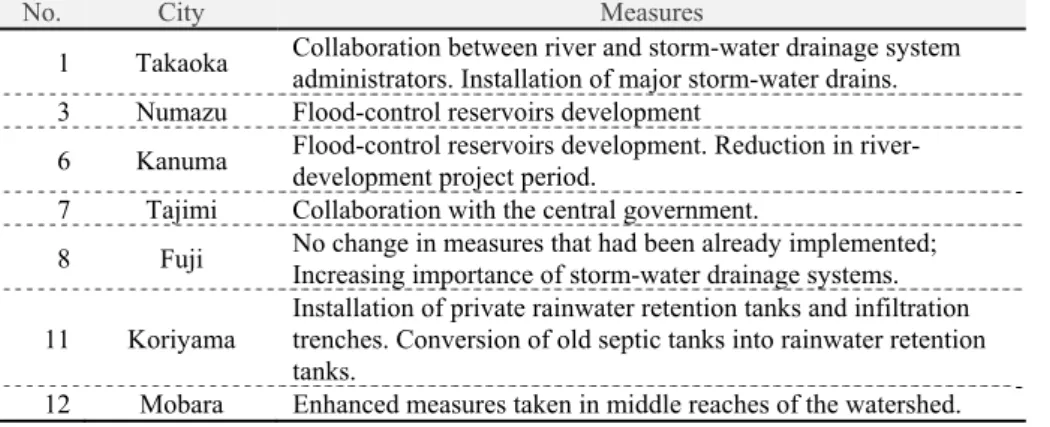
Tables 4-7 below illuminate changes in: 1) watershed management measures, 2) damage mitigation measures, 3) relevant regulations, and 4) public awareness, in association with the registration of a Safety Plan for 100mm/h-Rainfall, respectively.
Watershed management measures have changed in seven plans/cities (Table 4). Numazu, Kanuma and Koriyama started to install various sizes of rainwater retention/infiltration facilities such as storm-water reservoirs, infiltration trenches and inlets. Takaoka has installed major storm sewers and Fuji has emphasized the importance of a storm sewer network. Tajimi has strengthened collaboration with the central government. Mobara claims that the measures have enhanced the safety of the middle reaches of the watershed.
These cities, excluding Mobara, also report changes in damage mitigation measures (see Table 5). Takaoka, Numazu and Koriyama have revised the procedures of making and distributing flood hazard maps and disaster-risk information. Kanuma and Tajimi have strengthened collaboration with relevant administrators. Fuji has emphasized the importance of storm sewer networks as a damage mitigation measure as well.
Table 4. Changes in watershed management measures
No. City Measures
1 Takaoka Collaboration between river and storm-water drainage system administrators. Installation of major storm-water drains.
3 Numazu Flood-control reservoirs development
6 Kanuma Flood-control reservoirs development. Reduction in river- development project period.
7 Tajimi Collaboration with the central government.
8 Fuji No change in measures that had been already implemented;
Increasing importance of storm-water drainage systems.
11 Koriyama Installation of private rainwater retention tanks and infiltration trenches. Conversion of old septic tanks into rainwater retention tanks.
12 Mobara Enhanced measures taken in middle reaches of the watershed.
Table 5. Changes in damage mitigation measures
No. City Measures
1 Takaoka Creating/distributing flood hazard maps. Providing residents with risk/safety information via e-mail, etc.
3 Numazu Creating/distributing flood hazard maps. Providing risk information via the internet.
6 Kanuma Collaboration between private and public sectors for effective evacuation.
Information sharing for self-help. Cooperation between prefectural and city governments. Creating flood hazard maps.
7 Tajimi Subsidies from the central and prefectural governments.
8 Fuji No change in measures that had been already implemented;
Increasing importance of storm-water drainage systems.
11 Koriyama
Providing residents with risk/safety information. Creating flood hazard maps and using them for education. Flood drills and seminars. Installing water bars.
Table 6. Changes in relevant regulations
No. City Measures
1 Takaoka Implementing a subsidy program for installing private rainwater retention tanks (since Apr.1, 2013).
3 Numazu Subsidizing river cleanups by residents.
11 Koriyama Subsidizing two thirds of the cost of a private rainwater retention
Yamashita et al.
tank (continued project). *
*"Continued project" but described as a change in measures in association with the registration.
Table 7. Changes in public awareness for risk management
No. City Measures
1 Takaoka Strengthening public awareness about risk management by drills of sandbagging and by civic education for damage mitigation.
3 Numazu Public awareness has been improved by providing residents with information on river stages and rainfall intensities in real time.
6 Kanuma Inundation prevention measures have been promoting public awareness of risk management.
7 Tajimi The importance of evacuation activities has become better understood.
12 Mobara Public interest has been enhanced because of media attention.
8 Fuji Residents' awareness of risk management remains low.
11 Koriyama Awareness of the importance of self-help remains low; it should be strengthened by all means.
As for relevant regulations, three plans/cities report that there was a change (Table 6). Takaoka has provided a subsidy program for those who want to install private rainwater retention tanks and infiltration trenches/inlets. Numazu has subsidized citizens’ environmental activities, and Koriyama has renewed its subsidy program for citizens to install private rainwater retention/infiltration facilities.
Five plans/cities report changes in public awareness (Table 7). Takaoka, Numazu, Kanuma and Tajimi claim that the public awareness for flood- disaster risks and management has been increased. Mobara points out that public interest has been enhanced because of media attention. On the other hand, Fuji and Koriyama report the awareness remains low. The former group provides no objective evidence for increasing awareness in their response. It may be that the public awareness of risk management in general needs to be improved.
In addition, Fukuroi reports the registration system has enabled them to dredge rivers intensively to prevent inundation along them in a short time.
In contrast, Kanazawa, Yaizu, Hamamatsu, Nagoya, Okaya, Kitakyushu and Saga show no changes in relation to the registration of their Safety Plan for 100mm/h-Rainfall (Tables 4-7). Kanazawa, Yaizu, Hamamatsu and Nagoya have the same reason: because they had taken measures of comprehensive flood control long before their registrations, much earlier than the other cities. For instance, the city of Yaizu says: “Our Safety Plan for 100mm/h-Rainfall is no different than before because it was drawn up and registered base on the measures that the Committee of Comprehensive Watershed Management for the Ishiwaki/Takakusa Rivers (of Yaizu) had already been implementing”. Kanazawa explains: “We had already enforced an ordinance (concerning comprehensive flood control), so it (our Safety Plan for 100mm/h-Rainfall) does not necessarily include different measures (from those stipulated by the ordinance)”.
On the other hand, Kitakyushu and Saga imply, from the viewpoint of effectiveness, that change would occur in the future; Okaya says, “we just continue what we have implemented for flood control since before the registration”.
Moreover, the city of Fuji, which suggests changes in their storm-water drainage system, shows: “The measures (of our Safety Plan for 100mm/h- Rainfall) are not so different than before”.
Kanazawa, Yaizu, Hamamatsu, Nagoya, Kitakyushu and Fuji had
launched their committee for comprehensive flood control before the other
IRSPSD International, Vol.4 No.2 (2016), 18-29 cities, who clearly report the changes in the measures. Kanazawa, Yaizu, Hamamatsu, Nagoya, Kitakyushu and Fuji established their committees in 2009, 2005, 2005, 1987, 2003 and 2009, respectively (Table 3). They have tackled urban flood disasters from relatively early on.
3.3 Facilitating watershed management measures
0 2 4 6 8 10 12 14 16
Retention tank
Infiltration inlet
Infiltration trench
Figure 1. Promotions for private rainwater retention/infiltration facilities
0% 20% 40% 60% 80% 100%
Retention tank Infiltration inlet Infiltration trench
Subsidy Tax break Ordinace Environmental education Risk‐management education Others
Figure 2. Programs for private rainwater retention/infiltration facilities
Figure 1 shows whether the plans/cities have promotion programs for the installation of private rainwater retention tanks, storm-water infiltration trenches and inlets. Private tanks (13 plans/cities) and infiltration inlets (12 plans/cities) tend to be promoted more than infiltration trenches (three plans/cities). Figure 2 illustrates how the municipalities are trying to stimulate installation of these facilities. Risk-management education accounts for 40-50% of all the stimuli, including subsidies, tax benefits, ordinances, environmental education, risk-management education, etc..
Subsidy programs account for 20-30% in terms of both private retention tanks and infiltration inlets; and it is not considered, in this survey’s responses, as a stimulus for installing private infiltration trenches.
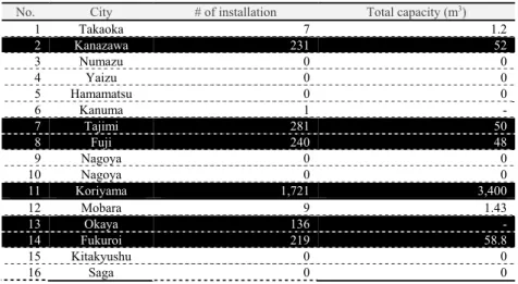
Table 8. Private rainwater retention tanks
No. City # of installation Total capacity (m
3)
1 Takaoka 7 1.2
2 Kanazawa 231 52
3 Numazu 0 0
4 Yaizu 0 0
5 Hamamatsu 0 0
6 Kanuma 1 -
7 Tajimi 281 50
8 Fuji 240 48
9 Nagoya 0 0
10 Nagoya 0 0
11 Koriyama 1,721 3,400
12 Mobara 9 1.43
13 Okaya 136 -
14 Fukuroi 219 58.8
15 Kitakyushu 0 0
16 Saga 0 0
Yamashita et al.
Note: Black represents cities emphasizing both private and public rainwater retentions.
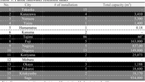
Table 9. Public rainwater retention tanks
No. City # of installation Total capacity (m
3)
1 Takaoka 15 -
2 Kanazawa 4 3,410
3 Numazu 5 5,300
4 Yaizu 1 1,400
5 Hamamatsu 1 0.18
6 Kanuma 2 -
7 Tajimi 86 60
*8 Fuji 5 163,000
9 Nagoya 5 837,00
10 Nagoya 13 149,800
11 Koriyama 2 25,073
12 Mobara - -
13 Okaya 3 1,188
14 Fukuroi 5 18,600
15 Kitakyushu 2 18,170
16 Saga - 934,000
Note: Gray represents cities emphasizing public retention; black: private and public.
* Approximate capacity shown as an example.
Tables 8 and 9 are to examine how private and public rainwater retention facilities are subsidized, installed or built in the registered plans/cities.
Nagoya, who has been tackling urban flooding from early on, has no subsidy program for private rainwater retention tanks, but the total capacity of its public rainwater retention facilities are overwhelming (Table 9). In a similar fashion, Numazu, Yaizu and Kitakyushu have no subsidy for private rainwater retention tanks, but they have installed or built relatively large, public rainwater retention facilities. Saga also has no subsidy for private rainwater retention/infiltration, but has the largest capacity of public retention function. Saga has developed irrigation-pond networks since ancient times because it was not able to irrigate water from major rivers that did not have enough longitudinal gradients. Those ponds can function not only for irrigation but also for runoff reduction (Kato, H., 1994).
As mentioned earlier (see Section 3.1), in the plans of Numazu, Yaizu, Nagoya (with 2 plans) and Saga, there are no descriptions of public involvement in the framework of their watershed management committees.
In Nagoya’s response, they point out limitation of private retention/infiltration facilities in flood control. The emphasis/dependency on public works may imply a trend in addressing comprehensive flood control by those who have been tackling it from relatively early on.
In contrast, Kanazawa, Tajimi, Fuji, Koriyama, Okaya and Fukuroi have both many private tanks subsidized by the local governments and public rainwater retention facilities that are overwhelming either in the number or in the total volume. They are well-balanced from the perspective of comprehensive, all-out effort that is indispensable for urban flood-disaster prevention/mitigation.
Furthermore, Koriyama stands out from all the other cities with the
number and total capacity of the installed rainwater retention tanks the city
subsidized. According to an additional interview with the city, the reasons
include: 1) relatively long period of time for the subsidy program (since
1996), 2) reusing old septic tanks, and 3) high public awareness of flood risk
management because of frequent occurrence of flooding.
IRSPSD International, Vol.4 No.2 (2016), 18-29
3.4 Facilitating/strengthening self-, mutual and public help as mitigation measures
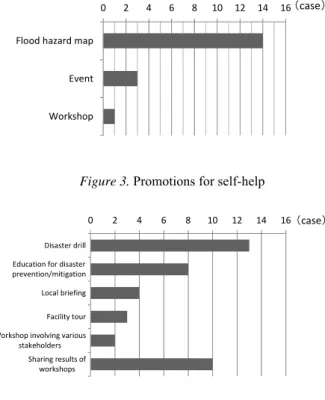
Figures 3-5 show how the registered plans/cities facilitate/strengthen self, mutual and public help as mitigation measures.
As a measure for facilitating self-help, flood hazard maps are employed in 14 plans and social events and workshops are used in four plans (Figure 3). Mutual help is facilitated with comprehensive disaster-preparedness drills and workshops in 13 plans and risk education is employed for mutual help in eight plans (Figure 4). Public help is strengthened by utilizing hazard maps in all the 15 plans; other measures such as risk/evacuation information collection/distribution, etc., are used in less than seven plans (Figure 5).
In summary, for flood-disaster mitigation, the municipalities who registered their Safety Plan for 100mm/h-Rainfall tend to utilize hazard maps to facilitate/strengthen self- and public help and educational activities to drive mutual help.
0 2 4 6 8 10 12 14 16
Flood hazard map
Event
Workshop
(case)
Figure 3. Promotions for self-help
0 2 4 6 8 10 12 14 16
Disaster drill Education for disaster prevention/mitigation Local briefing
Facility tour Workshop involving various
stakeholders Sharing results of
workshops
(case)
Figure 4. Promotions for mutual help
0 2 4 6 8 10 12 14 16
Systematic Sharing of information with residents
Creating hazard maps
Providing archives of flood disaster Collaboration with other
municipalities