FOREST VEGETATION OF THE OKI ISLANDS IN THE SOUTHWESTERN JAPAN SEA
Shuichi OKA
Abstract Based on physiognomical investigations in Dogo, Japan, it was proved that forests of the Oki Islands comprise a variety of vegetation types, ranging from cool temperate zone to warm temperate zone vegetation. These vegetation types were found to persist in a so-called intermediate temperate zone, where regions with a warmth index of less than 85ºC months (M) and a coldness index of more than -10ºC M meet. The presence of a variety of vegetation types in a mixed state was likely a result of the temperature environment and refuges formed when vegetation belts shifted following past climatic changes.
Key words: intermediate temperate zone, forest vegetation, warmth index, coldness index, Oki islands, refuges
1. Introduction
The Oki Islands of Japan are scattered in the southwest part of the Japan Sea in an area ranging from about 40 to 80 km north of the Shimane Peninsula. The region is divided into two parts, i.e., Dogo and Dozen; Dozen further comprises Nishi-no-shima Island, Naka-no-shima Island, and Chifuri Island, among others (Fig. 1). The islands tend to be exposed to northwesterly winds in winter, and are often covered by streaky clouds that develop over the Japan Sea. However, the islands always enjoy relatively warm and mild hydrographic conditions because of the influence of the Tsushima Warm Current. Dogo comprises various types of topography, such as Pleistocene plateaus, terraces, and alluvial plains, whereas Dozen consists of hilly lands. The highest point on Dogo is Mount Daimanji-san, at 607.7 m above sea level (asl), whereas that of Dozen is Mount Takuhi-san, at 451.7 m asl, on Nishi-no-shima Island. Both of these islands have few alluvial plains. Almost all of these regions are composed of effusive rocks of the Quarternary Period. In Dogo, the western region is formed of rhyolite of the Tertiary Period and the eastern region is formed of gneiss (Shimane Prefecture 1975). In this study, I attempted to evaluate the natural forest vegetation of the Oki Islands, with an emphasis on the temperature regime.
Fig. 1 The Oki Islands of Japan.
2. Forest vegetation of the Oki Islands
The forest vegetation of the Oki Islands was classified from a phytosociological perspective. The Ilici-Tsugetum sieboldii forest type covers the ridges on Dogo. Below that forest, the Castaneo -Quercetum crispulae type, together with coppice forests of Castanopsis cuspidata and Quercus glauca are found. Euonymo-Pittosperetum tobira appears in coastal areas, and Cryptomeria japonica or Pinus thunbergii grows on the slopes. In Dozen, whose top is situated at lower level, coppice forests of C.
cuspidata and Q. glauca grow on the ridges, whereas the Euonymo-Pittosporetum tobira type is observed in coastal areas. In addition, C. japonica and P. thunbergii are common forest species, especially the latter (Miyata and Sugimura 1982). Historically, a specific land use technique called makihata (meadow farming), wherein fields were rotated through use as pasture, farming fields and lying fallow, was practiced for a long time in this area (Tanaka 1979). Thus, the influence of human disturbance is distinctly noticeable.
The forests of the islands can be classified into several physiognomical types (Fig. 2): (1) mixed forest with coniferous and broad-leaved species (canopy layer: Quercus mongolica grosseserrata, Acer mono, Pinus parviflora, Abies firma), (2) summer-green forest (canopy layer: Quercus serrata, Carpinus laxiflora, Acer palmatum, and several other species; sub-canopy layer: Camellia japonica;
shrub layer: Rhododendron matternichii, Aucuba japonica, Cephalotaxus harringtonia), (3) Camellia japonica-dominated forest (canopy layer: Pinus densiflora, A. firma, C. laxiflora; sub-canopy layer:
C.japonica), and (4) Quercus salicina-dominated forest (canopy layer: Q. salicina; sub-canopy layer: C.
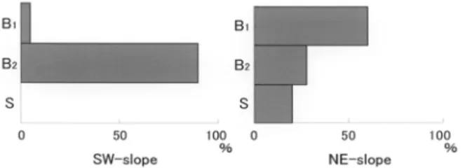
japonica; shrub layer: R. matternichii, C. japonica, Eurya japonica). Types (2) and (3) were observed on north-east and south-east slopes, respectively, and differences in stand structure were very distinct.
The coverage by layers is shown in Fig. 3. In type (2), the summer-green forest dominated the canopy layer, and the shrub layer was formed by poorly developed C. japonica from the sub-canopy layer. In
contrast, the dominance of the evergreen C. japonica in the sub-canopy layer of type (3) was remarkable; accordingly, there was no shrub layer. The most striking feature about the canopy species composition of the vegetation arrangement in the Dogo forests was the presence of both cool temperate zone forest and warm temperate zone forest.
Fig. 2 Vegetation types in Dogo, in the Oki Islands (except type (1)).
(2) summer-green forest; (3) Camellia japonica-dominated forest; (4) Quercus salicina-dominated forest.
Q.se: Quercus serrata; C.l.: Carpinus laxiflora; A.p.: Acer palmatum; C.j.: Camellia japonica; R.m.:
Rhododendron matternichi; C.h.: Cephalotaxus harringtonia; A.j.: Aucuba japonica; A.f.: Abies firma;
P.d.: Pinus densiflora; Q.sa.: Quercus salicina; E.j.: Eurya japonica.
Fig. 3 The canopy layers of two vegetation types in Dogo.
B1: canopy layer; B2: sub-canopy layer; S: shrub layer.
3. Distribution of forest vegetation in the Oki Islands based on temperature
Two indices, i.e., a warmth index and a coldness index (Kira 1945), were used to assess vegetation distribution based on climate. A warmth index ranging from less than 45 or 55ºC months (M) corresponds to subarctic zone forests, whereas an index of 45 or 55 to 85ºC M corresponds to forests of the cold temperate zone, and that of 85 to 140ºC M corresponds to forests of the warm temperate zone.
The establishment of a warm temperate forest is difficult in a zone with a coldness index of less than -10ºC M. In Japan, the subarctic zone is dominated by evergreen coniferous trees. The cold temperate
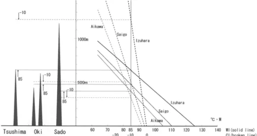
zone is dominated by deciduous broad-leaved trees (summer-green broad-leaved trees) represented by beeches, whereas the warm temperate zone is dominated by evergreen broad-leaved trees represented by oaks. A map of these types of indices in Japan was produced by Kira (1971), but the Oki Islands were considered to have a warmth index of less than 100ºC M and a coldness index of more than -5ºC M. Calculations of the mean values between 1971 and 2000 in Saigo (26.5 m asl), on the east coast of Dogo, resulted in a warmth index of 109.6ºC M and a coldness index of -1.9ºC M. According to these index values, broad-leaved trees corresponding to warm temperate forest should be dominant in the Oki Islands. The highest point on Dogo is 607.7 m asl. Calculation of warmth and coldness indices equivalent to an altitude of 526.5 m using the temperature lapse rate of 0.6ºC/100 m resulted in 81.2ºC M and -9.5ºC M, respectively. Based on the warmth index, a summer-green broad-leaved forest should be dominant at this altitudinal zone. However, growth of evergreen broad-leaved trees is also possible based on the coldness index. Across the entire Japanese archipelago, a mixed region between the cold temperate zone, where beeches predominate, and the warm temperate zone, where oaks are dominant, is called the intermediate temperate zone (Suzuki 1961). In this zone, although coldness develops, the warmth index is sufficient, and in some cases, it is impossible for either oaks or beeches to grow (A). In contrast, in other cases it is possible for either oaks or beeches to grow because of mild coldness, even if the warmth index is rather insufficient (B). The latter scenario applies to the Oki Islands, and a mixture of cold temperate forest and warm temperate forest becomes possible. Thus, a forest stand is formed in which C. laxiflora and C. japonica coexist. Data from Izuhara, Saigo, and Aikawa indicate that the Tsushima, Oki, and Sado Islands, respectively, which are situated in the littoral zone of the Japan Sea, can support forests in the intermediate temperate zone. Therefore, the former type (A) becomes possible In the Sado Islands, whereas the latter type (B) becomes possible in the Tsushima and Oki Islands (Fig.
4).
Fig. 4 Vertical distribution of warmth and coldness indices on islands in the Japan Sea.
WI: Warmth Index; CI: Coldness Index; black column: mountain on island.
Meteorological station: Izuhara (34°12′N, 129°18′E, 3.7 m) in the Tsushima Islands, Saigo (36°12′N, 133°20′E,
26.5 m) in the Oki Islands, Aikawa (38°01′N, 138°15′E, 5.5 m) in the Sado Island.
4. Cause of forest vegetation formation in the Oki Islands
As discussed above, the introduction of an intermediate temperate zone allows us to explain the forest vegetation in the temperate zone as temperature-dependent (Kira 1945). However, despite careful analysis of temperature ranges in which intermediate temperate zone forests are distributed (Nozaki and Okutomi 1990), further investigation is needed. In northeastern Japan, forests in the cold temperate zone are classified into two distinct types, i.e., forests in which beeches are dominant and forests in which beeches are mixed with other trees such as Q. mongolica grosseserrata. This classification is related to the occurrence of Sasa-type (dwarf bamboo) forest floor vegetation, such as Sasa kurilensis or S.
borealis, and corresponds to an environmental gradient represented by snow depth (Tanaka 2002).
Superimposing the record of forest fires on the distribution of cold temperate forest exhibits excellent correspondence, and the frequency of fires peaks on the Pacific (east) side of Japan, i.e., in the mixed forest region (Nakashizuka 2003). The mixed forest includes species of the intermediate temperate zone forests, such as Q. serrata, Castanea crenata, and C. laxiflora. As suggested above, the formation of forests in the intermediate temperate zone may be related to the history of large-scale disturbances.
However, although forest fires often occur in mixed forests, this does not imply that a forest fire is certain to result in the development of a mixed forest. Forest fires, which are concentrated in the period from February to April, often occur during the dry season in the east. Therefore, moisture conditions, governed by temperature or snow depth or both, may still be the primary factor influencing the formation of mixed forests. To explain the formation of a forest in the intermediate temperate zone, a multi-layered perspective is required, although in the Oki Islands, the intermediate temperate zone may be temperature-dependent. Snow is not as deep as in other regions (maximum recorded snow depth:
107 cm in 1962), and concurrently, the degree of disturbance is exceedingly great. Such complex conditions may therefore sustain this site, allowing trees of the so-called cold temperate zone, intermediate temperate zone, and warm temperate zone such as Q. mongolica grosseserrata, A. mono, P. parviflora, A. firma, P. densiflora, C. laxiflora, Q. serrata, Q. salicina, and C. japonica to coexist on such a small island.
Vegetation since the last glacial stage in western Japan has progressed from mixed forests with coniferous and broad-leaved species and temperate zone coniferous forests to evergreen broad-leaved forests (Tsukada 1985). Evergreen broad-leaved trees became established in mainland Japan approximately 6000 years ago, whereas establishment in the Oki Islands is thought to have occurred approximately 8000 years ago (Takahara and Tanida 2003). This implies that advancement of the warm temperate zone forest into the cold temperate zone forest occurred earlier than in other regions, suggesting the possibility that a refuge for warm temperate forest was secured in the last glacial stage.
On the other hand, Koizumi (1997) suggested that the existence of sub-high-mountain zone vegetation or the vegetation of northern Japan in a mixed state may be a relic of the glacial age. It is possible that the time-lag in the response of the vegetation zones to long-term environmental changes or the
formation of refuges is a major cause of the coexistence of a variety of vegetation types.
I wish to dedicate this paper to Prof. N. Hori on his retirement from Tokyo Metropolitan University.
I am grateful to thank Ms. A. Shirakawa for her help on drawing figures.
References
Kira, T. 1945. Nogyo-chirigaku no kiso toshite-no toa no shin-kikou-kubun (New climatic classification in eastern Asia as the basis of agricultural geography). Institute of Horticulture, Kyoto Imperial University.*
Kira, T. 1971. Seitaigaku kara mita Sizen (Nature from an ecological point of view). Tokyo:
Kawade-shobou-sinsha.*
Koizumi, T. 1997. Nihonkai no Tosho to Hantou no Shokubutu-sou (Flora of the islands and the peninsulas in the Japan Sea). In Aoshio Bunka (Aoshio Culture), eds. Ichikawa, T., Yamashita, S., Shirahata, S. and Koizumi, T., 144-162. Tokyo: Kokon-shoin.*
Miyata, I., and Sugimura, Y. 1983. Shimane-ken no Shokusei (Vegetation der Präfektur Shimane). In Vegetation of Japan Chugoku, ed. Miyawaki, A., 404-413. Tokyo: Shibun-do.*
Nakashizuka, T. 2003. Reconsideration of cool-temperate deciduous forest types in northern Japan.
Japanese Journal of Historical Botany 11(2): 39-43.**
Nozaki, R., and Okutomi, K. 1990. Geographical distribution and zonal interpretation of intermediate -temperature forests in eastern Japan. Japanese Journal of Ecology 40: 57-69.**
Shimane Prefecture 1975. Oki-no-shima Shizenkankyo-hozen-chiiki Gakujutsu-chosa Houkoku-sho (Report of the natural environmental survey of conservation areas in the Oki Islands). Matsue:
Shimane Prefectural Government.*
Suzuki, T. 1961. Nihon no shinrin-tai zen-ron (A hypothesis on the forest zonation in Japan). Chiri 6:
1036-1043.*
Takahara, H. and Tanida, Y. 2003. Shoyouju-rin ha saishu-hyoki no Ko-Oki-hantou ni nokotte-itaka?
(Did laurel forests remain on the Oki Peninsula in the Last Glacial Stage?). Proceedings of the 50th Annual Meeting of the Ecological Society of Japan: 109.*
Tanaka, T. 1979. Oki-no-shima no Rekishi-chirigakuteki Kenkyu (Historical geographic study of the Oki Islands), Tokyo: Kokon-shoin.**
Tanaka, N. 2002. Distribution and ecophysiological traits of dwarf-bamboo species and impact of climate changes in Japan. Global Environmental Research 6(1): 31-40.
Tsukada, M. 1985. Map of vegetation during the last glacial maximum in Japan. Quaternary Research 23: 369-381.
(*: in Japanese; **: in Japanese with English abstract)