中国チベット高原南東部プマユムツォ湖周辺のフロ ラ調査
著者 Minami Motoyasu, Tezuka Takafumi, Zhu Liping, Nishimura Mitsugu
著者別表示 南 基泰, 手塚 修文, 朱 立平, 西村 弥亜
journal or
publication title
The journal of phytogeography and taxonomy
volume 58
number 1
page range 50‑56
year 2010‑12‑30
URL http://doi.org/10.24517/00053433
Creative Commons : 表示 ‑ 非営利 ‑ 改変禁止 http://creativecommons.org/licenses/by‑nc‑nd/3.0/deed.ja
Motoyasu Minami1, Takafumi Tezuka2,3, Liping Zhu4 and Mitsugu Nishimura5: Survey of vascular flora around Lake Pumayum Co, an alpine lake located in the southeastern Tibetan plateau in China
南 基泰1・手塚修文2,3・朱 立平4・西村弥亜5 :中国チベット高原南東部プマユムツォ湖周辺のフロラ調査 Lake Pumayum Co(28°34′N, 90°24′E), located at an altitude of 5,030 m above sea level(a.s.l.), is a typical alpine lake formed by fault action in an intermountain basin of the Sino-Himalayan range in the southeastern Tibetan Plateau in China. With surface area of approximately 208 km2, Lake Pumayum Co has the largest area of any alpine lake located at over 5,000 m a.s.l.(Mitamura et al. 2004). Three islands were formed in the lake by tectonic activity, and we refer to these islands as Large Island, Middle Island, and Small Island in this manuscript, as they are unnamed on local maps of the area.
Because the lake is located at over 5,000 m a.s.l. and is surrounded by high mountains, unique vegeta- tion closely reflecting such an extreme environment is believed to exist there. However, limited informa- tion is available on the flora found around the lake area owing to restricted access for foreigners by the military. Furthermore, difficulties also arise when conducting research at an altitude of ca. 5,000 m a.s.l., where oxygen concentration is approximately half of that at sea level.
In 2006, we surveyed flora around the lake as well as on Middle Island to obtain baseline data that de- scribes the lakeshore vegetation and aids future systematic ecological surveys of the lake.
Field survey
A field survey of horizontal and vertical distributions of vascular plant species was conducted at 15 survey sites(ca. 10,000―50,000 m2/site)along the lakeshore and on Middle Island during August 12― 21, 2006. After tentative classification of the vegetation by physiognomy, we collected specimens from the vascular plant species growing at the 15 survey sites(Fig. 1)and identified them based on classifica- tions of Wu(1983, 1985a, b, 1986, 1987), the Institute of Tibetan Plateau Research(1988)and Yoshida
(2005). The local geographic characteristics are summarized below for each of the 15 survey sites around the lake and on Middle Island :
(1)Northern lakeshore : N1―1, floating sandy or peaty soil at riparian zone along the lake shoreline(5,020
―5,021 m a.s.l.); N1―2, gentle slope primarily consisting of coarse sandy soil and broken rock(5,021―5,128 m a.s.l.); N1―3, lake terrace with accumulated peaty soil(5,128―5,193 m a.s.l.).
(2)The river mouth of the outflow river on the eastern lakeshore : E1―1, riverbank that had accumu-
Fig. 1. Sketch map of the Lake Pumayum Co(28°34′N, 90°24′E, alt. 5,030 m above sea level).Letters in the sketch map refer to each survey sites.
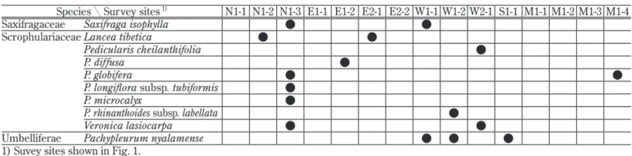
Species╲Survey sites 1) N1-1 N1-2 N1-3 E1-1 E1-2 E2-1 E2-2 W1-1 W1-2 W2-1 S1-1 M1-1 M1-2 M1-3 M1-4
Amaranthaceae Amaranthus sp. ● ●
Boraginaceae Lasiocaryum munroi ● ●
Microula tibetica ● ●
Brassicaceae Aphragmus oxycarpus ●
Dimorphostemon pinnatus ●
Draba oreades ●
Pegaeophyton scapiflorum ●
unidentified ● ●
CaryophyllaceaeArenaria bryophylla ● ● ● ● ● ● ● ● ●
Silene sp. ●
Chenopodiaceae Chenopodium sp. ● ● ● ●
Compositae Artemisia brevifolia ● ● ●
Erigeron multiradiatus ● ● ● ● ●
Leontopodium jacotianum
var. paradoxum ●
L. longifolium ● ● ● ● ●
L. nanum ●
Leontopodium sp. ●
Saussurea andryaloides ● ●
S. kingii ● ● ● ● ●
Taraxacum maurocarpum ● ●
T. sikkimense ●
Vladimiria berardioidea ●
Crassulaceae Rhodiola bupleuroides ●
R. crenulata ●
Sedum henrici-roberti ●
S. multicaule ● ●
Cyperaceae Carex aridula ● ● ● ● ● ● ●
C. moorcroftii ●
Eleocharis palustris ● ● ● ●
E. pauciflora ●
Kobresia humilis ● ● ● ●
K. macrantha ● ● ● ● ● ●
K. pratti ●
K. pygmaea ● ● ● ● ● ● ●
Gentianaceae Gentiana crassuloides ● ● ● ●
G. leucomelaena ● ●
G. micans ● ● ● ● ●
G. pedicellata ● ●
Swertia hispidicalyx ● ● ●
Labiatae Dracocephalum
heterophyllum ● ● ●
Phlomis rotata ● ● ● ● ● ● ●
Leguminosae Astragalus lasaensis ● ●
A. monticolus ● ● ●
A. strictus ● ●
Oxytropis lapponica ● ●
Liliaceae Allium sikkimense ● ●
Morinaceae Cryptothladia polyphylla ●
Nyctagynaceae Urtica hyperborea ● ●
Papaveraceae Corydalis hookeri ● ●
Hypecoum leptocarpum ●
Parnassiaceae Parnassia chinensis ●
P. pusilla ●
Poaceae Deyeuxia tibetica ● ●
Elymus nutans ● ● ● ●
Poa poophagorum ● ● ● ●
Stipa bungeana ● ●
S. purpurea ●
unidentified ● ● ● ●
Polygonaceae Bistorta perpusilla ● ● ●
Polygonum sibiricum ● ● ● ● ●
Primulaceae Androsace tapete ● ● ● ● ● ● ●
Lysimachia sp. ●
Ranunculaceae Delphinium caeruleum ● ●
Halerpestes tricuspis ● ● ● ● ● ● ● ●
Ranunculus nephelogenes ● ●
Rosaceae Potentilla anserina ● ●
P. biflora ●
P. saundersiana ● ● ●
Sibbaldia purpurea ● ●
Table 1. List of vascular plants around lakeshore and the Middle Island on Lake Pumayum Co
December 2010 J. Phytogeogr. Taxon. Vol. 58. No. 1
lated an alluvial substrate and was always saturated(5,014―5,021 m a.s.l.); E1―2, several river terraces along the riverbanks, consisting of gravel and shattered rock or peaty soil(5,021―5,029 m a.s.l.).
(3)The river mouth of an unnamed inflow river on the eastern lakeshore : E2―1, sandy soil near the river mouth(5,021 m a.s.l.); E2―2, sandy soil and pebbles around the river mouth(5,022 m a.s.l.).
(4)The Jidqu River delta on the western lakeshore : W1―1, hummocky terrain in a marsh(5,090 m a.s.l.); W1―2, peaty soil outside the marsh(5,090 m a.s.l.).
(5)River terrace of the Jidqu River on the western lakeshore: W2―1, at 10 km upward from the river mouth(5,090 m a.s.l.); this region is conditions almost identical to W1―2.
(6)Southern lakeshore : S1―1, poorly drained, hydric areas with saturated peaty soils(5,030 m a.s.l.).
(7)Middle Island : M1―1, pebbles from the weathering of the cliff face scattered along the lakeshore, preventing the accumulation of organic matter and peaty soil(5,024 m a.s.l.); M1―2, dry and firm, with an occasionally exposed matrix. Steep slope(5,024―5,029 m a.s.l.); M1―3, dry and firm with exposed matrix. Gentle slope(5,029―5,074 m a.s.l.); M1―4(in close vicinity of the summit), well-drained xeric habitat located on a scree slope with a ground surface consisting primarily of gravel and shattered rocks
(5,074―5,080 m a.s.l.).
Indicator species from the 15 survey sites were defined and then classified into vegetation types by two- way indicator species analysis(TWINSPAN)(PC-ORDTM 5, MjM Software Design)(Bruce and James 2002). All plant specimens collected were deposited at the Minami Laboratory, College of Bioscience &
Biotechnology, Chubu University, Japan.
Results and discussion
We identified 79 species of seed plants(including seven unidentified species)belonging to 24 fami- lies(Table 1, Appendix). Remarkable families represented by a number of species were Compositae(11 spp.), Cyperaceae(8 spp.), Scrophulariaceae(8 spp.), Poaceae(6 spp.), Brassicaceae(5 spp.)and Gentianaceae(5 spp.). The remaining families were represented by less than five species. We found no woody plants or pteridophytes at any of the survey sites.
Across all survey sites, the most common species were Arenaria bryophylla Fernald(nine sites), fol- lowed by Halerpestes tricuspis(Maxim.)Hand.-Mazz.(eight sites)and Androsace tapete Maxim., Carex aridula V. I. Krecz., Kobresia pygmaea(C. B. Clarke)C. B. Clarke and Phlomis rotata Benth. ex Hook.
f.(seven sites each). According to the Institute of Tibetan Plateau Research(1988), dominant plants around the lake include the genus Kobresia(dominant along the northern and eastern lakeshores)and genera Stipa and Artemisia(dominant along the southern and western lakeshores). However, the results of our survey did not corroborate this information because we were unable to confirm presence of the ge- nus Artemisia at the lakeshore. Furthermore, we observed Stipa bungeana Trin. only along the northern lakeshore(N1―2)and on Middle Island(M1―3)and Stipa purpurea Griseb.(M1―4)and Artemisia brevifolia Wall. ex DC.(M1―2, ―3 and ―4)only on Middle Island.
Nine indicator species were identified in four vegetation groups(A―D)derived from TWINSPAN at level three of sample hierarchy(Fig. 2). The following description characterizes each group in terms of Species╲Survey sites 1) N1-1 N1-2 N1-3 E1-1 E1-2 E2-1 E2-2 W1-1 W1-2 W2-1 S1-1 M1-1 M1-2 M1-3 M1-4
Saxifragaceae Saxifraga isophylla ● ●
Scrophulariaceae Lancea tibetica ● ●
Pedicularis cheilanthifolia ●
P. diffusa ●
P. globifera ● ●
P. longiflora subsp. tubiformis ●
P. microcalyx ●
P. rhinanthoides subsp. labellata ●
Veronica lasiocarpa ● ●
Umbelliferae Pachypleurum nyalamense ● ● ●
1) Suvey sites shown in Fig. 1.
Table 1. (continued)
A B
C D
Fig. 2. Two-way indicator species analysis(TWINSPAN)dendrogram showing vegetational similarity based on 15 survey sites. Letters refer to each survey site shown in Fig. 1.
Fig. 3. Typical views of the four vegetation types. A : Alpine desert steppe(M1―3 : 28°35′N, 90°28′E, 5,034 m above sea level (a.s.l.)). B : Alpine steppe(N1―2 : 28°35′N, 90°29′E, alt. 5,032 m a.s.l.). C : Alpine meadow (S1―1 : 28°29′N, 90°25′E, alt. 5,030 m a.s.l.). D : Marsh meadow(M1―1 : 28°35′N,90°28′E, alt. 5,024 m a.s.l.). Letters refer to each survey site shown in Fig. 1.
December 2010 J. Phytogeogr. Taxon. Vol. 58. No. 1
their indicator species and vegetation types. Group A(M1―2, ―3 and ―4)(Fig. 3A)is characterized by xerophytes Artemisia brevifolia, Corydalis hookeri Prain and Delphinium caeruleum Jacquem. ex Camb- ess. The vegetation comprising this group was observed on the entire slope and summit of Middle Island, except the lakeshore ; this region was defined as the alpine desert steppe. Group B(N1―2, N1―3, E1― 2, E2―2, W1―1 and W2―1)(Fig. 3B)is characterized by Androsace tapete, dominating the relatively dry soil lacking peat in the alpine steppe extending widely around the lakeshore. Group C(E2―1, W1―2 and S1―1)(Fig. 3C)is characterized by Pachypleurum nyalamense H. T. Chang et R. H. Shan in the alpine meadow, which consisted of peaty soil. Group D(N1―1, E1―1 and M1―1)(Fig. 3D)is characterized by the hygrophyte Polygonum sibiricum Laxm. in the marsh meadow, mainly inhabiting the saturated ripar- ian zone along the shoreline.
The zonation pattern of vegetation around Lake Pumayum Co and on Middle Island most probably cor- relates with a gradient of edaphic factors, especially soil moisture. In addition to these soil variables, the 150 inhabitants of Tsui Village located on the slope of a peninsula on the east of the lakeshore(5,050 m a.s.l.)(Fig. 1)have used the entire lakeshore to graze animals. This grazing pressure has resulted in the marked degradation of most of the survey sites. A possible reason for disparity in flora could be soil mois- ture and grazing pressure.
We thank Mr. Hideo Kihara of NHK in Japan for valuable information about Lake Pumayum Co and Dr. Tetuo Murakami of Nagoya Women’s University for providing us with a map of Lake Pumayum Co.
References
Bruce, McC. and James, B. G. 2002. Analysis of ecological communities. 300 pp. MjM Software Design, Gleneden Beach.
Institute of Tibetan Plateau Research. 1988. Vegetation of Xizang(Tibet). 589 pp. Science Press, Bei- jing. (in Chinese)
Mitamura, O., Seike, Y., Kondo, K., Goto, N., Anbutsu, K., Akatsuka, T., Kihira, M., Qiong, T. and Nishimura, M. 2004. Basic limnological study in an alpine lake Puma Yum Co, the pre-Himalayas, China. Rep. Res. Edu. Ctr. Inlandwat. Environ. 2 : 83―90.
Wu, C.-Y. 1983. Flora Xizangica Vol. 1. 790 pp. Science Press, Beijing. (in Chinese) Wu, C.-Y. 1985a. Flora Xizangica Vol. 2. 956 pp. Science Press, Beijing. (in Chinese) Wu, C.-Y. 1985b. Flora Xizangica Vol. 4. 1021 pp. Science Press, Beijing. (in Chinese) Wu, C.-Y. 1986. Flora Xizangica Vol. 3. 1047 pp. Science Press, Beijing. (in Chinese) Wu, C.-Y. 1987. Flora Xizangica Vol. 5. 955 pp. Science Press, Beijing. (in Chinese) Yoshida, T. 2005. Himalayan plants illustrated. 799 pp. Yama-Kei, Tokyo. (in Japanese)
摘要
プマユムツォ湖は,中国・チベット高原南東部の北緯28°34',東経90°24',標高 5,030 mに位置する淡水湖で,
標高5,000m以上にある湖としては世界最大規模である。この湖は非常に高所にあり,軍事制限地域になって
いるため,これまでに湖周辺のフロラについての詳細な調査はされてこなかった。2006年本湖周辺15ヶ所 でフロラ調査を行なった結果,24科79種(7種が未同定)が確認され,そのうちキク科(11種),カヤツリ グサ科(8種),ゴマノハグサ科(8種),イネ科(6種),アブラナ科(5種)及びリンドウ科(5種)が多数 の種を含む主要な科で,残りの科はいずれも4種以下であった。
フロラ調査を行なった15ヶ所について二元指標種分析(TWINSPAN)を行なった結果,指標種と植生の 相違から以下の4グループに分割できた。グループAは湖の島の湖岸を除く砂礫斜面全域と頂上のみで,乾 生植物のArtemisia brevifolia, Corydalis hookeri及びDelphinium caeruleumが指標種となる高山荒原で あった。グループB は湖周辺に広く分布する腐食質が堆積しない比較的乾燥した場所に成立し,Androsace tapeteが指標種となる高山ステップであった。グループCは未腐食質が堆積し,Pachypleurum nyalamense が指標種となる高山草原であった。グループD は湖畔の土壌水分が飽和した湖岸で,湿生植物の Polygonum
sibiricumが指標種となる湿地草原であった。このような湖周辺の植生の違いは,土壌水分の違いと放牧によ
る採食圧の違いによるものと推測された。
(1College of Bioscience & Biotechnology, Chubu University, 1200, Matsumoto-cho, Kasugai, Aichi 487
―8501, Japan ; 2Division of Life Sciences, Graduate School of Science, Nagoya University, Chikusa-ku, Nagoya 464―8601, Japan ; 3School of Health and Human Life, Nagoya Bunri University, Inazawa-cho, In- azawa 492―8520, Japan ; 4Institute of Tibetan Plateau Research, Chinese Academy of Sciences, No.18 Sh- uangqing Road, Beijing 100085, China ; 5Graduate School of Marine Science and Technology, Tokai Uni- versity, 3―20―1, Orido, Shimizu, Shizuoka 424―0902, Japan 1〒487―8501 愛知県春日井市松本町1200 中部大学応用生物学部;2〒464―8601 愛知県名古屋市千種区 名古屋大学大学院理学研究科生命理学専攻;
3〒492―8520 愛知県稲沢市稲沢町 名古屋文理大学健康生活学部;4〒100085 中国北京市双清路18号 中国科学院青蔵高原研究所;5〒424―8610 静岡県清水市折戸 3―20―1 東海大学海洋学部)
(Received July 24, 2010 ; accepted November 6, 2010)
Appendix
All specimens collected around Lake Pumayum Co, except Amaranthus sp., Rhodiola crenulata(Hook.
f. & Thomson)H. Ohba and Urtica hyperborea Jacq. ex Wedd., were deposited at the Minami Laboratory in the College of Bioscience & Biotechnology, Chubu University, Japan. The above three plants were not collected for specimens, because we identified three plants locally. Therefore three specimens are not in- cluded in the list of following specimens.
Monocotyledoneae
Cyperaceae : Carex aridula V. I. Krecz.(CH060674); C. moorcroftii Falc. ex Boott(CH060601); Eleo- charis palustris(L.)Roem. et Schult.(CH060670); E. pauciflora(Lightf.)Link(CH060700); Kobre- sia humilis(C. A. Mey. ex Trautv.)Serg.(CH060672); K. macrantha Boeck.(CH060588); K. pratti C. B. Clarke(CH060671); K. pygmaea(C. B. Clarke)C. B. Clarke(CH060621). Liliaceae : Allium sikkimense Baker(CH060616). Poaceae : Deyeuxia tibetica Bor(CH060769); Elymus nutans Griseb.
(CH060602); Poa poophagorum Bor(CH060586); Stipa bungeana Trin.(CH060592); S. purpurea Griseb.(CH060699); unidentified(CH060730).
Dicotyledoneae Choripetalae
Brassicaceae : Aphragmus oxycarpus(Hook. f. et Thomson)Jafri(CH060710); Dimorphostemon pin- natus(Pers.)Kitag.(CH060587); Draba oreades Schrenk(CH060635); Pegaeophyton scapiflorum
(Hook. f. et Thomson)C. Marquand et Airy Shaw(CH060625); unidentified(CH060709). Caryo- phyllaceae : Arenaria bryophylla Fernald(CH060591); Silene sp.(CH060609). Chenopodiaceae : Chenopodium sp.(CH060596). Crassulaceae : Rhodiola bupleuroides(Wall. ex Hook. f. et Thomson) S. H. Fu(CH060582); Sedum henrici-roberti Raym.-Hamet(CH060633); S. multicaule Wall. ex Lindl.
(CH060712). Leguminosae : Astragalus lasaensis C. C. Ni et P. C. Li(CH060767); A. monticolus P.
C. Li et C. C. Ni(CH060679); A. strictus Graham ex Benth.(CH060585); Oxytropis lapponica(Wahl- enb.)Gay(CH060593). Papaveraceae : Corydalis hookeri Prain(CH060594); Hypecoum leptocarpum Hook. f. et Thomson(CH060599). Parnassiaceae : Parnassia chinensis Franch.(CH060802); P. pu- silla Wall. ex Arn.(CH060617). Polygonaceae : Bistorta perpusilla(Hook. f.)Greene(CH060765); Polygonum sibiricum Laxm.(CH060598). Ranunculaceae : Delphinium caeruleum Jacquem. ex Camb- ess.(CH060583); Halerpestes tricuspis(Maxim.)Hand.-Mazz.(CH060639); Ranunculus nephelo- genes Edgew.(CH060622). Rosaceae : Potentilla anserina L.(CH060542); P. biflora Willd. ex Schltdl.
(CH060715); P. saundersiana Royle(CH060707); Sibbaldia purpurea Royle(CH060611). Saxifra- gaceae : Saxifraga isophylla Harry Sm.(CH060787). Umbelliferae : Pachypleurum nyalamense H. T.
Chang et R. H. Shan(CH060620). Sympetalae
Boraginaceae : Lasiocaryum munroi(C. B. Clarke)I. M. Johnst.(CH060691); Microula tibetica Benth.(CH060626). Compositae : Artemisia brevifolia Wall. ex DC.(CH060584); Erigeron multira-
December 2010 J. Phytogeogr. Taxon. Vol. 58. No. 1
diatus(Lindl. ex DC.)Benth. ex C. B. Clarke(CH060619); Leontopodium jacotianum Beauverd var.
paradoxum(J. R. Drumm.)Beauverd(CH060606); L. longifolium Ling(CH060624); L. nanum(Hook.
f. et Thomson)Hand.-Mazz.(CH060697); Leontopodium sp.(CH060694); Saussurea andryaloides
(DC.)Sch. Bip.(CH060589); S. kingii C. E. C. Fisch.(CH060600); Taraxacum maurocarpum Dahl- st.(CH060608); T. sikkimense Hand.-Mazz.(CH060768); Vladimiria berardioidea(Franch.)Ling
(CH060785). Gentianaceae : Gentiana crassuloides Bureau et Franch.(CH060648); G. leucomelaena Maxim. ex Kusn.(CH060807); G. micans C. B. Clarke(CH060618); G. pedicellata(Wall. ex D. Don) Griseb.(CH060743); Swertia hispidicalyx Burkill(CH060753). Labiatae : Dracocephalum hetero- phyllum Benth. (CH060590); Phlomis rotata Benth. ex Hook. f.(CH060603). Morinaceae : Cryptoth- ladia polyphylla(DC.)Cannon(CH060729). Primulaceae : Androsace tapete Maxim.(CH060636); Lysimachia sp.(CH060690). Scrophulariaceae : Lancea tibetica Hook. f. et Thomson(CH060771); Pedicularis cheilanthifolia Schrenk (CH060607); P. diffusa Prain(CH060711); P. globifera Hook.
f.(CH060692); P. longiflora Rudolph subsp. tubiformis(Klotzsch)Pennell(CH060786); P. microca- lyx Hook. f.(CH060788); P. rhinanthoides Schrenk ex Fisch. et C. A. Mey. subsp. labellata(Jacquem.) Pennell(CH060623); Veronica lasiocarpa Pennell(CH060612).