A Study on Advantage of MFAN Technology for GIS -Introduce the MFAN technology-
Yoon-Seuk Oh*, Jin-Hyun Choo**, Young-Seok Kim**, Hyun-Sang Choi* and Seung-Ok Lim***
ABSTRACT
Early 2000, new concept of a city was made in South Korea which is named U-City, and there are more 50 regions which are making the plan of U-City around the nation. The two of core technologies of U-City are USN and spatial information technology. Because, most services of U-City are made from the convergence technology between electronic communication technology and GIS. In this case, it is possible to wireless communication for send the data like the USN sensor data or property information in the air, but it is not possible in underground. Therefore, it is impossible to communicate between sensor and aggregator in buried environment like underground using typical wireless communication technology like the WiFi, ZigBee. But, underground facilities, which are ‘water supply’,
‘sewer’, ‘power line’, ‘gas’ etc., must be managed by USN in U-City. This paper discusses about advantage of MFAN Technology which can communicate in buried environment and how to use it for GIS field like the U-City applications.
Keywords : MFAN, U-City, Underground Facility, UIS, Magnetic Field Communication 1. Introduction
Early 2000, new concept of a city was made in South Korea which is named U-City, and there are more 50 regions which are making the plan of U-City around the nation. The U-City means the city which is implemented ubiquitous technologies. The budget for U-City is more 100 billion dollars a year. It is one of huge industry in South Korea.
In the U-City, USN (Ubiquitous Sensor Network) role is neural networks in the city. USN is made by communication technologies and Sensor technologies.
And most communication technology of USN is wireless type, like CDMA, WiFi, ZigBee and Bluetooth. All of typical wireless communication technologies are used the electric wave. But electric wave can’t penetrate through the soil, water and metal.
* Korea Institute of Construction Technology (KICT), Ubiquitous Land Implementation Research Division
** KICT, Geotechnical Engineering & Tunnelling Research Division
*** Korea Electronics Technology Institute, Wireless Network Research Center.
Contact : [email protected]
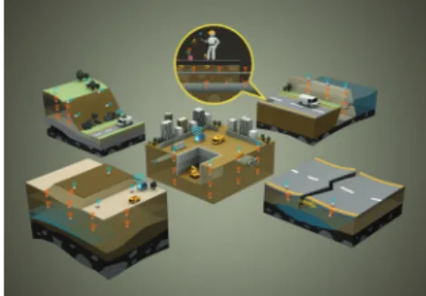
The underground facilities real time management service is core U-City service model. And there are a lot of sensors which can measure state of pipe like water supply, sewed, gas line.
But most pipe lines are buried. Therefore, it is impossible to make wireless sensor network in underground environment using typical wireless communication technology.
This paper discusses about advantage of MFAN Technology which can communicate in buried environment and how to use it for GIS field like the U- City applications.
2. MFAN Overview 2.1 Principle of MFAN
Full Name of MFAN is ‘Magnetic Field Area Network’. It is new local area network technology using low frequency band around 128KHz. It was adopted Korean Standard (KS-X 4651) in 2009 and it is discussed in ISO (International Organization for Standardization) now.
The permittivity (the affection of the attenuation of
electric wave), in the water, is about 80 times higher then air. Unlike the electric wave, magnetic field has little variation in lots of materials. Because, the permeability (the affection of the attenuation of magnetic field), in the most materials, is similar with the air.
But, MFAN has disadvantage which is low baud rates.
It supports rates of 1kbps to 8kbps.
2.2 Advantage of MFAN against Normal Wireless Network
As the principal of the MFAN, it has advantage of wireless network in buried condition. Most underground environment consists with soil, water, metal and air. So, it can make the USN in buried condition. MFAN was tested about communication ability in the aluminum box (Metal condition) with ZigBee module. In the same condition as figure 1, MFAN can send data but Zigbee couldn’t it.
FIGURE 1. MFAN test using aluminum box 3. MFAN Applications Model
3.1 GIS Applications for U-City
Most GIS application field is underground facilities management in South Korea local governments. As below figure 2, MFAN can make system about real time life line monitoring using sensors like flow meter.
It can prevent the sudden accident with pipe line.
FIGURE 2. Service model of pipe line management
3.2 Other Applications
And, MFAN is adopted in underground measurement field, like poor ground, dams, levees measuring or road crack check.
FIGURE 3. Service model of underground measuring 3.3 Power Problem and Solution
Underground wireless network has fatal shortcoming.
It is power support method. Wireless network use battery, but it is hard to change the battery in buried condition.
The solution of this problem is energy harvesting technique. We suggest MHD for solve the problem.
MHD is ‘Magneto Hydro Dynamics’. It generates the electricity use flow water in the pipe like water supply or sewed. We make a modulation of MHD generator. As figure 4 shows, it could turn on the LED lights.
FIGURE 4. MHD Generator 4. Conclusions
Now, the spatial information technology is no more S/W industry, it is S/W and H/W convergence industry.
Especially, it will be powerful ubiquitous technology, which is combined GIS and USN.
The new GIS can use present data not past data like the traditional GIS. MFAN is going to be the tool of changing paradigm of the spatial information industry.
Acknowledgments
This work was supported by the IT R&D program of MKE/KEIT. [10033338, Platform Technology for Underground Facilities Management]