1. Introduction
The occurrence of earthquakes can be regarded as the releases of tectonically accumulated elastic strain energy through dynamic fault ruptures. Given this, the entire earthquake generation process generally consists of tectonic loading, quasi-static rupture nucleation, dynamic rupture propagation, and fault strength recovery. We can now quantitatively describe the entire earthquake generation process with coupled nonlinear equations, consisting of a slip-response function, a fault constitutive law, and relative plate motion. The slip-response function, which relates fault slip to shear stress change, is a solution of the equation of motion in continuum mechanics. The
fault constitutive law, which prescribes shear strength change with fault slip and contact time, is an energy balance equation in fracture zones. The relative plate motion is a driving force of the coupled nonlinear system. Thus, the essence of earthquake generation modeling is quite simple, but it is not easy to develop a predictive simulation model, because the actual world is complex in structure and also in material properties.
In the first phase (2003-2005) of the project, we constructed a realistic 3-D model of plate interface geometry in and around Japan, represented by the superposition of about 30,000 bi-cubic splines [1]. On this structure model we developed a quasi-static stress accumulation model and a dynamic rupture propagation
Development of a Predictive Simulation System for
Crustal Activities in and around Japan - VIII
Project RepresentativeChihiro Hashimoto
Graduate School of Environmental Studies, Nagoya University AuthorsChihiro Hashimoto
*1, Eiichi Fukuyama
*2, Toshiko Terakawa
*1, Takeshi Sagiya
*1,
Kengo Nakajima
*3, Toshinori Sato
*4and Mitsuhiro Matsu'ura
*5*
1 Graduate School of Environmental Studies, Nagoya University*
2 National Research Institute for Earth Science and Disaster Prevention*
3 Information Technology Center, The University of Tokyo*
4 Faculty of Science, Chiba University*
5 Institute of Statistical Mathematics, Research Organization of Information and SystemsOur research group aims to develop a physics-based predictive simulation system for crustal activities in and around Japan, which consists of a combined simulation model for quasi-static stress accumulation and dynamic rupture propagation and the associated data assimilation software. In the first phase (2003-2005), we constructed a prototype of the combined simulation model on a realistic 3-D structure model. In the second phase (2006-2008), we tested the validity and applicability of the combined simulation model, and demonstrated that the physics-based computer simulation is useful for the quantitative evaluation of strong ground motions that will be produced by potential interplate earthquakes. We also developed the associated data assimilation software; that is, a GPS data inversion method to estimate interplate coupling rates, a CMT data inversion method to estimate crustal stress fields, and a GPS inversion method to estimate 3-D elastic/inelastic strain fields. Applying the GPS data inversion method to interseismic GPS data (1996-2000) in Japan, in 2008, we have estimated the slip-deficit rate distribution on the North American-Pacific plate interface along the Kuril-Japan trench, and, in 2009, on the Eurasian-Philippine Sea plate interface along the Nankai trough-Ryukyu trench. In 2010, applying the same GPS data inversion method to interseismic GPS data in the central part of Japan (the Kanto region), we estimated the slip-deficit rate distribution on the North American-Philippine Sea and Philippine Sea-Pacific plate interfaces along the Sagami and Suruga troughs. In 2010, we also developed a method to take into account the effects of the free surface on dynamic rupture propagation by introducing a hypothetical horizontal interface that satisfies stress-free conditions into the homogeneous unbounded elastic medium. Focusing on the temporal changes in slip-velocity patterns in the early stages of the second earthquake cycle after the first event, we performed combined simulation for quasi-static stress accumulation and dynamic rupture propagation. At the very early stage, we can find a remarkable slip-velocity excess (afterslip) zone in the deepest part of the seismogenic region, which corresponds to the brittle-ductile transition zone characterized by low peak strength and large slip-weakening distance.
model. Then, given the past fault-slip history, we performed the combined simulation of quasi-static stress accumulation and dynamic rupture propagation for the 1968 Tokachi-oki earthquake (Mw=8.2), and demonstrated that when the stress
state is close to a critical level, dynamic rupture is rapidly accelerated and develops into a large earthquake, but when the stress state is much lower than the critical level, started rupture is not accelerated [2]. So, the problem is how to know the past fault-slip history and how to monitor the present stress state. In the case of Japan, fortunately, we have nation-wide dense geodetic and seismic observation networks such as GEONET operated by GIS (Geographical Survey Institute of Japan) and F-net operated by NIED (National Research Institute for Earth Science and Disaster Prevention).
In the second phase (2006-2008), we developed the associated data assimilation software; that is, a GPS data inversion method to estimate interplate coupling rates [3], a CMT data inversion method to estimate crustal stress fields [4], and a GPS data inversion method to estimate 3-D elastic/inelastic strain fields [5]. Applying the GPS data inversion method [3] to GEONET data (GSI) in the Hokkaido-Tohoku region for the interseismic calm period of 1996-2000, we estimated the slip-deficit rate distribution on the North American-Pacific plate interface, and revealed that the inverted five slip-deficit peaks almost completely coincide with the source regions of 10 large interplate earthquakes (M>7.5) occurred along the Kuril-Japan trench in the last century [6]. Based on the inversion results, we performed the combined simulation of quasi-static stress accumulation, dynamic rupture propagation and seismic wave propagation for the 2003 Tokachi-oki earthquake (Mw=8.1),
and demonstrated that the physics-based computer simulation is useful for the quantitative evaluation of strong ground motions
that will be produced by potential interplate earthquakes [7]. In 2009, applying the GPS data inversion method to interseismic GPS data in the southwestern part of Japan, we estimated the slip-deficit rate distribution on the Eurasian-Philippine Sea plate interface along the Nankai trough-Ryukyu trench, and revealed that a high slip-deficit rate belt extends from the Suruga Bay to the Bungo Channel. On the basis of the inversion results, we computed stress accumulation rates in the seismogenic region, and performed a numerical simulation for the dynamic rupture of a potential Nankai-trough earthquake by using the boundary integral equation method.
2. Interplate slip-deficit rate distribution in and
around Japan inverted from GPS data
In 2010, applying the GPS data inversion method [3] to horizontal velocity data at GEONET stations in the central part of Japan for the interseismic calm period of 1996-2000, we estimated precise slip-deficit rate distribution on the North American-Philippine Sea and Philippine Sea-Pacific plate interfaces along the Sagami and Suruga troughs. In the analysis, to remove rigid body translation and block rotation from the observed GPS data, we transform the velocity data into the average strain rates of triangular elements composed of adjacent GPS stations [9]. By this transformation, original information about intrinsic deformation is preserved. Thus, we completed the estimate of interplate coupling rates on the whole plate interfaces in and around Japan. From the slip-deficit rate distribution inverted from GPS data shown in Fig. 1, we can find the high slip-deficit zones along the trench/troughs in the Japan region, corresponding to the past and potential source region of large interplate earthquakes.
Fig. 1 The slip-deficit rate distribution inverted from GPS data ([6,9], Hashimoto, Sagiya & Matsu'ura, SSJ 2009 Fall Meeting). The blue contours indicate the slip-deficit rate.
3. Combined simulation for quasi-static stress
accumulation and dynamic rupture propagation
In 2010, we also developed a method to take into account the effects of the free surface on dynamic rupture propagation by introducing a hypothetical horizontal interface that satisfies stress-free conditions into the homogeneous unbounded elastic medium [10]. Applying this method to computation of the dynamic rupture process of the 2008 Iwate-Miyagi earthquake (Mw=6.9), we demonstrated that the effects of the free surface ondynamic rupture propagation is significant in the shallower part of the seismogenic fault.
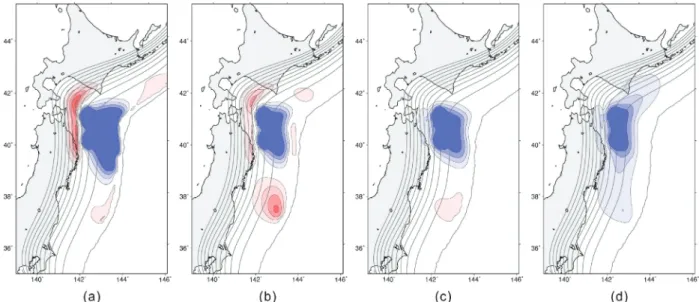
Now, focusing on the temporal changes in slip-velocity patterns in the early stages of the second earthquake cycle after the first event, we performed combined simulation for quasi-static stress accumulation and dynamic rupture propagation in the 1968 Tokachi-oki seismogenic region [11]. For this computation, we gave the fault slip history in the first earthquake cycle, and then start the quasi-static simulation of tectonic loading for the second earthquake cycle. The panels (a), (b), (c), and (d) in Fig. 2 show the slip-velocity patterns at 1, 2, 3, and 8 yr after the first event, respectively. We can find the slip-velocity deficit zone extending over the source region of the first event at every stage. This indicates the very fast strength recovery in the source region. At the very early stage (a), we can find a remarkable slip-velocity excess (afterslip) zone in the deepest part of the seismogenic region, which corresponds to the brittle-ductile transition zone characterized by low peak strength and large slip-weakening distance. The stress transfer due to viscoelastic relaxation in the asthenosphere may accelerate the afterslip at the depths.
References
[1] C. Hashimoto, K. Fukui, and M. Matsu'ura, "3-D modelling of plate interfaces and numerical simulation of long-term crustal deformation in and around Japan," Pure Appl. Geophys., vol.161, pp.2053-2068, 2004.
[2] M. Matsu'ura, "Quest for predictability of geodynamic processes through computer simulation", Computing in Science & Engineering, vol.7, pp.43-50, 2005.
[3] M. Matsu'ura, A. Noda, and Y. Fukahata, "Geodetic data inversion based on Bayesian formulation with direct and indirect prior information," Geophys. J. Int., vol.171, pp.1342-1351, 2007.
[4] T. Terakawa and M. Matsu'ura, "CMT data inversion using a Bayesian information criterion to estimate seismogenic stress fields," Geophys. J. Int., vol.172, pp.674-685, 2008.
[5] A. Noda and M. Matsu'ura, "Physics-based GPS data inversion to estimate 3-D elastic and inelastic strain fields," Geophys. J. Int., doi:10.1111/j.1365-246X.2010.04611.x, 2010.
[6] C. Hashimoto, A. Noda, T. Sagiya, and M. Matsu'ura, "Interplate seismogenic zones along the Kuril-Japan trench inferred from GPS data inversion," Nature Geoscience, vol.2, pp.141-144, 2009.
[7] E. Fukuyama, R. Ando, C. Hashimoto, S. Aoi, and M. Matsu'ura, "A physics-based simulation of the 2003 Tokachi-oki, Japan, earthquake toward strong ground motion predictions," Bull. Seism. Soc. Am., vol.99, pp.3150-3171, 2009.
[8] T. Yabuki and M. Matsu'ura, "Geodetic data inversion using a Bayesian information criterion for spatial distribution of fault slip," Geophys. J. Int., vol.109, pp.363-375, 1992.
Fig. 2 Temporal changes in slip velocity patterns in the early stages of the second earthquake cycle. The panels (a), (b), (c), and (d) show the slip-velocity patterns at 1, 2, 3, and 8 yr after the first event, respectively. The red and blue contours represent the slip-slip-velocity excess and deficit to steady relative plate motion, respectively. The contour intervals are taken to be 20% of steady relative plate velocities.
[9] A. Noda, C. Hashimoto, Y. Fukahata, and M. Matsu'ura, "Inversion of interseismic GPS array data to estimate slip-deficit rates at plate interfaces: Application to the Kanto region, central Japan," Geophys. J. Int., 2011 (submitted). [10] S. Hok and E. Fukuyama, "A new BIEM for rupture
dynamics in half-space and its application to the 2008 Iwate-Miyagi Nairiku earthquake," Geophys. J. Int., vol.184, pp.301-324, 2011.
[11] C. Hashimoto, E. Fukuyama, and M. Matsu'ura, "Physics-based 3-D simulation for the entire process of earthquake generation at plate interfaces in subduction zones," Geophys. J. Int., 2011 (submitted).
日本列島域の地殻活動予測シミュレーション・システムの開発 - Ⅷ
プロジェクト責任者橋本 千尋
名古屋大学 大学院環境学研究科 著者橋本 千尋
*1,福山 英一
*2,寺川 寿子
*1,鷺谷 威
*1,中島 研吾
*3,佐藤 利典
*4,
松浦 充宏
*5*
1 名古屋大学 大学院環境学研究科*
2 防災科学技術研究所 地震研究部*
3 東京大学 情報基盤センター*
4 千葉大学 理学部 地球科学科*
5 情報・システム研究機構 統計数理研究所 本研究プロジェクトは、複雑なテクトニック環境の下にある日本列島及びその周辺域を一つのシステムとしてモデル 化し、プレート運動に伴う長期的な地殻変形から大地震の発生まで、時間・空間スケールの著しく異なる地殻活動現象 を統一的且つ定量的に予測する並列シミュレーション・システムを開発し、モデル計算と観測データを併合した日本列 島域の地殻活動予測シミュレーションを行うことを目的としている。地殻活動予測シミュレーション・システムは、日本列島域の 3 次元標準構造モデル(CAMP Standard Model; Hashimoto, Fukui & Matsu'ura, PAGEOPH, 2004)上に構築された、準静的応力蓄積モデル、動的破壊伝播モデル、及び地震/地殻変 動データの解析・同化ソフトウェアから成る。平成 20 年度には、モデル計算と観測データの融合に向け、直接的及び間 接的先験情報を考慮した GPS データの逆解析手法(Matsu'ura, Noda & Fukahata, GJI, 2007)を北海道-東北地域の地震間 (1996-2000)の GPS 速度データに適用して北米-太平洋プレート境界の詳細なすべり遅れ分布を求め(Hashimoto, Noda,
Sagiya & Matsu'ura, Nature Geoscience, 2009)、その結果に基づいて 2003 年十勝沖地震の準静的応力蓄積―動的破壊伝播― 地震波動伝播の連成シミュレーションを行ない、将来的に発生が予想されるプレート境界地震による地震動を定量的に 予測することが可能なことを示した(Fukuyama et al., BSSA, 2009)。平成 21 年度は、上記の GPS データ逆解析手法を西 南日本域に適用してユーラシア-フィリピン海プレート境界の詳細なすべり遅れ分布を明らかにした(Hashimoto, Sagiya & Matsu'ura, SSJ 2009 Fall Meeting)。平成 22 年度は、上記の GPS データ逆解析手法を関東地域に適用して北米-フィリ ピン海、及びフィリピン海-太平洋プレート境界の固着-すべり状態を推定し(Noda, Hashimoto, Fukahata & Matsu'ura, 2011, GJI, submitted)、昨年度までの結果と合わせて、日本列島全域の震源域のすべり遅れレートの詳細な分布を明らか にした。また、日本列島域の地殻活動予測シミュレーション・システムについては、動的破壊伝播モデルに自由表面の 効果を導入する手法を開発し、その効果を評価した(Hok & Fukuyama, GJI, 2011)。更に、1968 年十勝沖地震の震源域に 於ける,過去の地震による影響を取り込んだ地震発生サイクルシミュレーションにより、地震発生直後に応力蓄積レー トが顕著に増大し、やがて時間と共に一定値まで減少すること、また、深部の脆性-延性遷移領域では余効すべりが地 震後数年間に亘り継続することが明らかにした(Fukuyama, Hashimoto & Matsu'ura, GJI, submitted)。
![Fig. 1 The slip-deficit rate distribution inverted from GPS data ([6,9], Hashimoto, Sagiya & Matsu'ura, SSJ 2009 Fall Meeting)](https://thumb-ap.123doks.com/thumbv2/123deta/5742722.524660/2.892.173.708.796.1131/deficit-distribution-inverted-hashimoto-sagiya-matsu-fall-meeting.webp)