トップページ - 横浜国立大学学術情報リポジトリ
13
0
0
全文
(2) Introduction "Kohkoku-chishi (Imperial Topography)" is based on a series of surveys conducted by the Meiji Government in the early Meiji Era (late 19th century) to grasp the actual situations in towns and villages in Japan. The result of the surveys was summarized by each prefecture and submitted to the national government. However, most of them were destroyed by fire in the wake of the Kanto Great Earthquake, failing to be published. Fortunately some of the original reports have remained in tact in some parts of Yokohama with reprints made available a s "Kanagawaken Kohkoku-chishi Sagami-no-kuni Kamakuragun-sonshi (Imperial Topography of Villages in the Kamakura-gun, Sagami-no-kuni, Kanagawa-ken) " (Kanagawa Library Association, Kyodo Shiryo Henshu Iinkai : Committee to compile materials concerning local history, 1991). The document provides detailed information about each village, including the history, terrain, characteristics of the soil, taxable land, number of houses, hills and rivers, temples and shrines, etc. Especially the information included in such sections a s terrain, hills, forests and shrines contain some description about vegetation, albeit a little, serving as valuable materials to study the vegetation landscapes of those days. Topographical Survey Section of the General Staff Office made a series of 1: 20,000 scale topographical maps of the whole Kanto region during 7 years from 1880 to 1886. Today these maps are called Jinsoku-zu. Being the first maps based on modern surveying method, they can be called the prototypes of the present-day topographical maps in Japan (Ono, 1952). The Jinsokuzugenzu (original survey drawings for Jinsoku-zu), which were made a s part of the process to make Jinsoku-zu, though never published, employed so-called French style, which was to draw the maps in the form of colored diagrams, complete with notes of plant names such a s pine tree, Japanese cedar, and oak (Quercus serrata and Q. acutissima). Jinsoku-zu maps are the ones published after integrating 4. -. 16 pieces of these maps into one and changing its style to a. German one (Shimizu, 1979). The original survey drawings for Jinsoku-zu are characterized by the abundance of information about vegetation a s well a s the planimetric information. Incidentally, the original survey drawings for Jinsoku-zu that the authors used are the ones reprinted by Japan Map Center in 1991 a s "Meiji Zenki Tegaki Saishoku Kanto Jissoku-zu" (Hand-drawn colored surveyed maps of the early Meiji Era). The authors' intention here is to obtain the overview of the vegetation in the 1880's of the southwestern parts of Yokohama City, including Seya-ku, Izumi-ku, Totsuka-ku, Kohnan-ku and Sakaeku, because Kohkoku-chishi materials on this area, which used to be called Sagami-no-kuni Kamakura-gun in those days, remain available to this day. Other studies about vegetation landscape using Jinsoku-zu or original survey drawings for Jinsoku-zu include: Ogura (1993, 1994), Harada & Harada (1995, 19971, Masubuchi & Kaminishi (1997), Yamada et al. (19971, and Harada et al. (1998).. Vegetation Landscape Seen from Descriptions in Kohkoku-chishi 1. Firewood and Charcoal Conditions Table 1 shows the conditions of firewood and charcoal supply in each village in the southwestern part of Yokohama in the 1880's when Kohkoku-chishi was compiled. The authors made this list from contents in the section of terrain. Judging from the information, it is clear that many of the villages did not experience deficiency in firewood and charcoal to be used a s fuel a s is evident from the comment, "No shortage of firewood and charcoal." In five villages, namely Kuden-.
(3) Table 1 Description about number of houses, population, area of hills and woodland, firewood. and charcoal conditions and trees in Shinto shrines. Village 1. Household 349. Population 2057. Forest area 22 1. Firewood. Trees. 0. AA. 0 "Superabundance. 0 "No. X. A Pinus thunbergii or P. densiflora. of firewood and charcoal" "Deficient in firewood and charcoal" A Cryptomeria japonica Ginkgo biloba Quercus spp.. 0 Acer. shortage of firewood and charcoal". palmatum Castanopsis cuspidata var. sieboldii D Zelkova serrata.
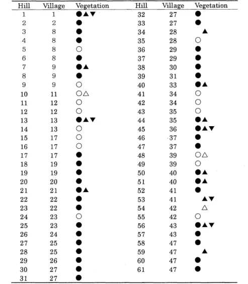
(4) mura (No. 25), Katsura-mura (No. 26), Kamino-mura (No. 27), Nakano-mura (No. 28) and Tohge-mura (No. 471, they enjoyed plentiful supply of firewood and charcoal as can be inferred from the remark, "Superabundance of firewood and charcoal." According to the material, the villages with superabundance of firewood and charcoal had a large expanse of hills and woodland, the total area of which reached 50 ha or more inclusive of enclaves. The greater the number of houses in the village, the larger the amount of firewood and charcoal to be consumed there, required the larger area of hills and woodland to meet the demand. However, the number of houses in these villages was small, with the largest one being mere 72, which means a small number of houses had a use of wide area of hills and woodland. On the other hand, there were villages that suffered from a shortage of firewood and charcoal, albeit but few. Totsuka-Yoshida-machi (No. 15) and Kasaoka-mura (No. 32) are noted a s "deficient in firewood and charcoal." The area of hills and woodland belonging to these villages was 22 ha in the case of the former. However, it can be surmised that the area where the villagers had a free access to was not sufficient. In the case of the latter (62 houses), it had only 9 ha of hills and woodland, which suggests lack of coppice. Southwestern part of Yokohama as a whole did not suffer from a shortage of firewood and charcoal, implying there was a wide distribution of coppice. 2. Trees in the Precincts of Shinto Shrines Table 1 also summarizes the information about trees growing in the precincts of Shinto shrines, based on the contents of the section of "Yashiro" (Shinto shrines) in Kohkoku-chishi. For 9 shrines of the total of 50, it is described that there were no old trees in their precincts, while giant trees and old trees are shown growing in the precincts of the 41 other shrines. The names of the species listed as the trees in these shrines include pine (Pinus thunbergii or Pinus densiflora), Japanese cedar (Cryptomeria japonica), maple (Acer palmatum), Gynkgo biloba, Castanopsis cuspidata var. sieboldii, evergreen oak (Quercus spp.), and Zelkova serrata. In terms of the number, pine accounts for the overwhelming majority, a t 82, followed by Japanese cedar, Castanopsis cuspidata var. sieboldii, though the latter two are much smaller in their numbers. It looks like there was no deciduous oak (Quercus serrata and Quercus acutissirna) among big trees, although many oaks are found in hills and woodland. The number of trees in the area around shrines are small at 5 or less with most of them having only 1 to 3 trees around them. In order to describe the size of the trees, estimated age of the tree has been added, such as, "more than 200 years old." There is no description about the height of the trees, but the diameter of the trees is expressed in terms of "kakomi" which means the circumference of the trunk.. 3. The Vegetation on the Hills Table 2 summarizes the information on the vegetation obtained from the description in the section of hills. It shows evergreen a n d / o r deciduous broad-leaved trees and pine trees covered many of the hills in the southwestern part of Yokohama. While some of such forests existed a s thinly spaced growth, it can be read from the material that many of them formed dense stands. A variety of archaic words that are used to portray the state of the growth all clearly indicate quite high density of the growth. However, because the description about the size and height of trees is completely lacking, information obtained from Kohkoku-chishi alone is not sufficient to judge whether the vegetation on the hills was big trees or shrub. Existing studies (Ogura, 1994; 1995: Harada, 1995) point out that the vegetation on hills in.
(5) Table 2 Information about vegetation mentioned in the section about hills. Hill 1. Village 1. Vegetation eAV. Hill 32. Village 27. Vegetation. The shape of the symbol represents the species: circle represents evergreen and/or deciduous broadleaved trees; triangle represents pine trees; and inverted triangle stands for Japanese cedar. The black symbols show dense plant growth while the plain ones show thin growth.. Yokohama City, Kamakura City and Miura Peninsula consisted of trees of relatively low stature. As for tree species, little is stated, with the only mentions of Japanese cedar, pine, evergreen and /or deciduous broad-leaved trees. It can be concluded that Japanese cedar mentioned here is. Cryptomeria japonica while pine here is either Pinus thunbergii or Pinus densiflora. As Japanese cedar is not indigenous to this area, Japanese cedar forests that are forming communities must be all artificially established ones. Only five hills are described clearly a s having Japanese cedar growths, which are Nakamaru-yama (No.. 11, Tomizuka-yama (No. 131, Ueno-yama (No. 451, Ise-. yama (No. 53), and Takada-yama (No. 56). According to the description of the material, these hills also had forests of pine trees and evergreen and/or deciduous broad-leaved trees. Thus it can be surmised that the area covered by Japanese cedar forests was very small..
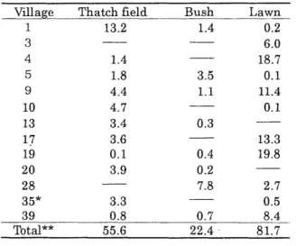
(6) Since pine forests are plant communities that appear in the sera1 stage of the succession except for edaphic climax, there must have been no pine forests a s natural vegetation with the exception being Pinus thunbergii forests on coastal cliffs. Therefore the pine forests were presumably either artificial growths or the communities that invaded disturbed habitats including logged sites and established themselves there a s secondary growths. Evergreen and/or deciduous broad-leaved trees mentioned here are trees that are not Japanese cedar or pine. Thus their species can not be identified. In all likelihood, they included deciduous broad-leaved trees such a s Quercus serrata, Cornus controversa, Styrax japonicus a s well a s laurel trees that constitute climax forests in this area such a s Persea thunbergii, Castanopsis cuspidata var. sieboldii and Quercus myrsinaefolia. Undoubtedly, some forests were managed by villagers through measures including regular logging and collection of fallen leaves, because people must have planted and harvested trees such a s Quercus serrata and Quercus acutissima a s raw materials for firewood and charcoal. At the same it is most likely that there were also forests in varied successional stages from the ones that had just been invaded by laurel trees, to mixed forests of deciduous broad-leaved trees and laurel trees, and to evergreen broad-leaved forests dominated by laurel trees representing a more advanced stage of succession. However, considering the situation in those days where they depended on forests for the source of energy necessary for everyday life a s well a s for organic fertilizer to apply to their agricultural land, it is highly probable that the area of forests that were left unutilized was fairly small. Therefore it can be surmised that evergreen and/or deciduous broad-leaved trees mentioned here were mostly. deciduous broad-leaved trees, mainly. Quercus serrata, Quercus. acutissima, Styrax japonicus, Cornus controversa, Carpinus tschonoskii, Mallotus japonicus and Prunus spp. 4. The Conditions of Grasslands The land category subject to taxation, apart from residential land, agricultural land, hills and woodlands, include thatch fields, bushes, lawns and fodder fields. Kohkoku-chishi contains information about the area of such land calculated for each village. The grasslands that had an area of more than 3 ha are listed in Table 3. Thatch fields were the common where villagers collected grass to thatch the roof with. Approximately 56 ha of such common existed in total. The portions described a s bushes are conjectured to be land unutilized by villagers, such as logged sites and abandoned agricultural land with plant communities consisting of the mixture of shrubs and herbaceous plants that colonized the tracts. Therefore the vegetation referred to a s bushes presumably lump together various vegetation types from early-successional to seral-stage communities. Only two villages have shrubs covering an area of 3 ha or more, with the total area of all bushes being approximately 22 ha. Lawns account for the largest area at approximately 82 ha. Since it is unthinkable that there was as large a demand a s today's for lawns (Zoysia japonica) in those days, what are described a s lawns were not lands used for lawn production but grazing grounds for cattle. Out of 47 towns and villages, only 3 villages have land clearly defined a s fodder fields, which fact suggests it is highly likely that thatch fields and lawns were actually used a s fodder fields. Fodder fields are places to collect fodder. But since the term is used only for wild fields, hills and woodland that are used a s the common by the residents in a specific area and thus sometimes also referred to a s thatch fields (Shinmura, 1997), it is suspected that some of the authors of Kohkoku-chishi did not distinguish between thatch fields, lawns and fodder fields. Incidentally there are only 3 villages that have areas clearly defined as fodder fields, with the largest area. ".
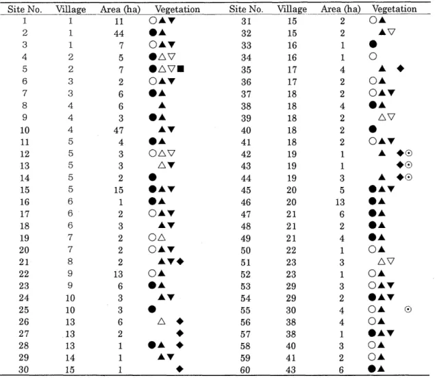
(7) Table 3 Villages with 3 h a o r more a r e a of thatch fields, bushes o r lawns, Unit: h a , -- indicates the area is less than 0.1 ha.. Village 1 3 4 5 9. 10. Thatch field 13.2. Bush 1.4 -. 1.4 1.8. 3.5. 4.4 4.7. -. * In addition, the village h a s 5.9 h a of * *The total of 47 towns and villages.. 1.1. Lawn 0.2 6.0 18.7 0.1 11.4 0.1. fodder fields.. being 5.9 ha. These grasslands account for approximately 160 h a in total, accentuating the vegetation landscape in the area.. 5. The Conditions of Forests Table 4 summarizes descriptions about forests and groves in general. There were very few publicly-owned forests and most of them were in private ownership. In addition, large forests t h a t cover 10 h a o r more a r e found in only 6 places, many being relatively small forests of a n a r e a of 5 h a o r less. Pinus spp., Cryptomeria japonica,. Chamaecyparis obtusa, Quercus. acutissima and Zelkova serrata a r e mentioned a s the species growing in forests but dominant in population were Pinus spp., Cryptomeria japonica, evergreen and / o r deciduous broad-leaved trees. Especially notable is the fact that pine trees outnumbered evergreen and/or deciduous broadleaved trees. Pine trees and evergreen and/or deciduous broad-leaved trees were also dominant in the vegetation on hills but Japanese cedar was smaller in population on hills. Supposedly, it is attributable t o the fact that Japanese cedar trees were planted only on flatlands and parts where alluvial plains and hills meet that were included in the descriptions about forests. Although we did not include the information in the table, the original description mentioned something about the circumference of the trees in such way a s , "kakomi (circumference of the tree) ranges from 90 cm to 210 cm." "Kakomi" probably means the circumference of trunks within 1 -- 2 m from the ground. It is known that Teisatsuroku (report of a n investigation that w a s conducted in parallel with the effort to create topographical m a p s in 1880's), which w a s made in the s a m e period with Kohkoku-chishi, called the circumference of the trees a t the height of human eyes a s "medoushi" (Ogura, 1994). Moreover, there a r e some descriptions that suggest there were not only dense stands of trees but also forests with low stature o r density, a s is indicated by such comments a s , "small pine.
(8) 66. Table 4 Information about vegetation mentioned in the section about forests. Site No.. Village. 1 2. 1 1 1. 3 4. 5 6. 7 8 9 10 11 12 13 14 15 16 17 18 19 20 21 22 23 24 25 26 27 28 29. 30. 2 2 3 3 4 4 4. 5 5 5 5 5 6 6 6. 7 7 8 9 9. 10 10 13 13 13 14 15. Area (ha) 11 44 7 5 7 2 6 6 3 47 4 3 3 2 15 1. 2 3 2 2 2 13 6 3 3 G 2 1. 1 1. Vegetation. O A ~ .A OAV. anv anow OAV A .A AV .A. ono nr. •. .AV .A OAV AV. on. OAV AV+ OA .A AV. •. + + .A + AV + n. Site No. 31 32 33 34 35 36 37 38 39 40 41 42 43 44 45 46 47 48 49 50 51 52 53 54 55 56 57 58 59 GO. Village 15 15 16 16 17 17 18 18 18 18 18 19 19 19 20 20 21 21 21 22 23 23 29 29 30 38 38 40 41 43. .. &ea (ha) Vegetation 2 OA 2 AV 1 1 0 4 A 2 OA 2 OAV 4 .A 2 AV 2 . 2 OAV 1 A +0 1 +0 3 A +0 5 mAV 13 6 .A 2 .A 4 .A 1. OA. 3. AV. 1. OA OAV .AV OA. 3 2 4 4. +. 0. OA. 1. .AV. 3 2 6. 01 OA *A. The shape of the symbol represents the species: circle represents evergreen and/or deciduous broadleaved trees; triangle represents pine trees (Pinus thunbergii or P. densiflora); inverted triangle stands for Japanese cedar (Cryptomeria japonica); square is for oak (Quercus acutissima); lozenge for Japanese cypress (Chamaecyparis obtusa); and double circle is for Zelkova serrata. The black symbols show dense plant growth while the plain ones show thin growth.. trees are thriving" or "there are only a small number of evergreen a n d / o r deciduous broadleaved trees." It is also learned from the material that there were some hills that lay bare due to logging.. Vegetation Landscape Seen from Jinsokuzu-genzu 1. Comparative Study of Maps of Different Villages The following are the characteristics of the vegetation landscape of the said period revealed by examining four different sheets of Jinsokuzu-genzu (original survey drawings for Jinsoku-zu) which cover the m.ost of the area studied.. 8.
(9) (1) The map of Shinano-mura / Kami-Kashio-mura Hills cover the most of the area with these hills dissected by dendritic alluvial plains called yato. The hills are covered with trees, which are predominantly Quercus acutissima across the whole area. Especially in the southeastern part, the letters that stand for Quercus acutissima overspread the entire area. Many of these woods were supposedly used a s the source of raw materials for firewood and charcoal. In the central part of the map depicting the area close to the border with Tsuzuki-gun, some evergreen and/or deciduous broad-leaved trees occur with few oaks ( Quercus serrata) growing among them. There are many pine trees along the old Tokaido Highway and around human settlements. Judging from some old photographs taken in 1860's (Yokohama Archives of History, 19871, many of the pine trees along the old highway were Pinus thunbergii, with some of them remaining there to this day. In the central and southeastern part of the area in the map, several parcels of Bokusouchi (land covered by grass and shrubbery) are found on the slopes of the hills, although the area of each is small. Most of the alluvial plains are used a s paddy fields, while land on the lower parts of the hills and sunken places are used a s fields. (2) The map of Shimo-Kashio-mura / Maioka-mura. Hills dominate the most part of this map and there are very few flatlands, which are found on 0. the alluvial plain and hilltops. Forests spread on hills. Evergreen and/or deciduous broad-leaved trees account for a large area with Quercus serrata, and pine trees and Quercus acutissima occurring among them in some parts. Pine trees are clustered on the alluvial plain of the Kashio River in the western part. Japanese cypress (Chamaecyparis obtusa) and Japanese cedar are found in several places but the total area they cover is not large. Symbols indicating grasslands, thatch field and lawn dot the area, suggesting a landscape studded with small grasslands. Especially notable are a number of grasslands symbols found on the slopes of hills. They characterize the vegetation landscape on hills. The alluvial plain and yato (dendritic alluvial plains dissecting hills) are used a s paddy fields. Although the alluvial plain along rivers and around their bents is used a s fields, most of the fields are on hills or flatlands on their slopes. (3) The map of Akuwa-mura / Okatsu-mura. Topographically, this area can be divided into two: the hilly zone in the eastern part and the plateau in the western part. The hilly zone is covered with forests and fields, with the area of the former and the latter being about the same. Most of the trees are Quercus serrata with some pine trees and Quercus acutissima occurring among them. In the southern part of the area, there are also some evergreen and/or deciduous broad-leaved trees in addition to them. Paddy fields are developed on yato while fields are on the slopes of hills. Fields increase toward the plateau in the western part. Fields and mulberry fields extend on the plateau in the western part, serving as the most distinctive feature of the vegetation landscape of those days. Paddy fields are also found in sunken places on the plateau that has gentle rises and falls. Woods exist on borders between fields and paddy fields a s well as around Shinto shrines. But the total area of the woods in this area is not large. Forests on the plateau consist mainly of pine trees, supplemented by Quercus serrata, Quercus acutissima and evergreen and/or deciduous broad-leaved trees. Thatch fields and lawns are also found in several places along old Ohyama Highway but their area is very small..
(10) Fig. 1 Jinsokuzu-genzu, depicting the a r e a around' Totsuka-eki and Maioka-mura showing hills a n d yato (dendritic alluvial plains). (Partial, ~ 0 . 7 )The original copies of the two m a p s belong to the Geographical Survey Institute. The figures shown here a r e photo-copies of reprints created by J a p a n Map Center.. Fig. 2 Jinsokuzu-genzu depicting the a r e a around Nakata-mura and Gumisawa-mura. (Partial, ~ 0 . 7 ).
(11) (4) The map of Totsuka-eki / Fukaya-mura. With the plateau occupying more than half of the area, in the eastern part, the alluvial plain of Kashio River stretches in narrow strips from north to south. The eastern end of the plateau forms a slope full of ups and downs. Fields extend over the plateau, with lowland area used a s paddy fields. Stands of pine trees and Quercus serrata dot the borders between fields and paddy fields. Some of the fields along old Tokaido Highway have lawns and grasslands in them. There are forests and fields on the slope where the plateau and the alluvial plain meet. The forests consist mainly of pine trees and Quercus serrata but they are intermingled with some Japanese cypress and Japanese cedar. Bamboo forests are observed in the back of the settlements in the southern part. No mention of made of Quercus acutissima and evergreen and/or deciduous broad-leaved trees. Except for some parts along river channels, the alluvial plain is almost completely covered with paddy fields. 2. Comparative Study of Forests. @. (1) The relationship between forests and terrain Forests and groves distribute mainly on hills and the plateau. The hills are mostly covered with forests, although fields and grasslands are found interspersing in some parts. The species found in them are predominantly broad-leaved trees including Quercus serrata, Quercus acutissima and evergreen and/or deciduous broad-leaved trees, with pine trees occurring only in some parts. On the other hand, agricultural land extends over the plateau, with forests and groves existing like islands dotting the area. In terms of species, pine is somewhat larger in its population than Quercus serrata and Quercus acutissima. Kohkoku-chishi describes vegetation on hills in most areas as dense or thin stands of evergreen and/or deciduous broad-leaved trees. There are relatively limited areas where pine trees are dominant or interspersing among broad-leaved trees (Table 2). Contrarily, in the case of vegetation in forests, pine trees are somewhat dominant (Table 4). If we assume information mentioned in the section of hills is about vegetation in hilly zones while that in the section of forests is about woods in the plains, the description in Kohkoku-chishi and the information obtained from symbols indicated in Jinsokuzu-genzu (original survey drawings for Jinsoku-zu) are in agreement with each other, both representing the characteristic feature of the vegetation of this area, where many broad-leaved forests are found on hills while there are many pine forests on the plateau. (2) Geographical inclination in the growths of particular wood species. Quercus serrata and pine trees are distributing uniformly across the area while Quercus acutissima and evergreen and/or deciduous broad-leaved trees are occurring unevenly. The map of "Totsuka-eki and Fukaya-mura" in the southwestern part does not include any indication of Quercus acutissima and evergreen and/or deciduous broad-leaved trees. That is also the case with which sits in the southeastthe southern part of the map of "Shimo-Kashio-mura/Maioka-mura", ern part. Therefore, the distribution of Quercus acutissima and evergreen and/or deciduous broadleaved trees seems to be concentrated toward the northern part of the area. However, if we compare the maps of two adjoining areas, indicated vegetation symbols show a sudden change from one map to the other in some cases, lacking in consistency. For example, although the southeastern part of the map of "Shinano-mura/Kami-Kashio-mura" indicates a conlocated in its centration of Quercus acutissima, the map of "Shimo-Kashio-mura/Maioka-mura" immediate south does not show any symbols of Quercus acutissima but all there are symbols of Quercus serrata and pine trees. This kind of disparity in the indication of species is probably.
(12) attributable to the difference in recognition of vegetation among surveyors. This difference by surveyors may be especially true of the indications about Quercus serrata, Quercus acutissima and evergreen and/or deciduous broad-leaved trees. Therefore Jinsokuzu-genzu alone can not serve a s the basis for judgment on whether there was any particular geographical inclination in the distribution of Quercus acutissima and evergreen and/or deciduous broad-leaved trees.. Summary The authors discussed the vegetation landscape in the southwestern part of Yokohama during the early Meiji Era using Kohkoku-chishi and Jinsokuzu-genzu that were made in the 1880's. As a result, the following has been learned: 1) dense stands of coppice extended broadly over the hills; 2) many of the forests were either the ones dominated by Quercus serrata and Quercus acutissima or those consisted of evergreen and/or deciduous broad-leaved trees, with either the evergreen or the deciduous being dominant; 3) pine forests did occur on hills but they were especially plentiful in the plateaus and plains; 4) yet, each forest or grove covered only a limited area; 5) Japanese cedar forests were found more in the plains than on hills; 6) there were grasslands such as thatch fields or lawns but they were small in their area; 7) the plateau was used mainly a s fields and mulberry fields while the alluvial plain and the dendritic alluvial plains (yato) were used mainly for paddy fields. Although old photographs typically play an important role in studying the vegetation landscape in the past, in the case of this study, the authors failed to obtain photographs of the said area taken in the said period. In future, it is necessary to study the vegetation landscape based on such photographs as well.. Acknowledgements The authors would like to express our sincere appreciation to Dr. Junichi Ogura, Faculty of Literature, Kyoto Seika University, who provided instructions on several materials to help in conducting this research.. References Harada, H. 1995. The vegetation landscape of Kamakura in the early-mid Meiji Era read from Kohkoku-chishi and old photographs. Tsuchi to Midori no Kai Kaiho (Journal of Association of Soil and Plant), (14): 1-20 (in Japanese). Harada H., & A. Harada 1995. The mapping of vegetation in the early Meiji Era and the change of vegetation during 110 years in Yokohama City. ECO-HABITAT: JISE Research, 2: 25-33 (in Japanese with English synopsis). Harada H., & A. Harada 1997. Vegetation of Honmoku district of Yokohama City in the early Meiji Era. ECO-HABITAT: JISE Research, 4: 23-31 (in Japanese with English synopsis). Harada H., A. Harada & K. Hotta 1998. Vegetation mapping in Shin-Yokohama district of Yokohama City in the early Meiji Era and the changes of vegetation during 115 years. ECOHABITAT: JISE Research, 5: 1-10. Jinsokusokuzu Genzu Fukkokuban Henshu Iinkai (Editorial committee for the reprinted version of original survey drawings for Jinsoku-zu) (ed.) 1991. Meiji Zenki Tegaki Saishoku Kanto Jinsokuzu (Hand-drawn colored surveyed maps of the early Meiji Era). Japan Map Center,.
(13) Tokyo (in Japanese). Kanagawa Library Association, Kyodo Shiryo Henshu Iinkai (Committee to Compile Materials Concerning. Local. History). (ed.). 1991. Kanagawa-ken. Kohkoku-chishi. Sagami-no-kuni. Kamakuragun-sonshi (Imperial Topography of Villages in Kamakura-gun, Sagami-no-kuni, Kanagawa-ken) . 699pp. Kanagawa Library Association, Yokohama (in Japanese). Masubuchi, K., & A. Kaminishi. 1997. Vegetation in the early Meiji era in Tama hills, the South Kanto. Bulletin of the Kawasaki Municipal Science Museum for Youth, (8): 1-24 (in Japanese). Ogura, J . 1993. A study of the meanings of the vegetation marks of the maps called Jinsoku-zu. Journal of Kyoto Seika University, (5): 40-69 (in Japanese with English summary). Ogura, J . 1994. A study of vegetation of the Kanto region in the 1880's. Journal of Kyoto Seika University, (7) : 101- 143 (in Japanese with English summary). Ogura, J . 1995. Vegetation in the southwestern Kanto region between the late Edo period and the middle Meiji era through the study of old photographs. Journal of Kyoto Seika University, (8): 15-43 (in Japanese with English summary). Ono, M. 1952. Jinsoku-sokuzu to Kasei-chikeizu (Topographical surveying and maps in Japan). The Human Geography, 4 (2): 38-45 (in Japanese). Shimizu, S. 1979. Study on the content of 1: 20,000 scale Jinsoku-sokuzu. Bulletin of the Rekishichirigaku (Historical geography), 21 : 103-122 (in Japanese). Shinmura, I. 1997. Kohjien (Japanese Dictionary) fourth edition. 2858pp. Iwanami Shoten, Tokyo (in Japanese). Yamada, A., H. Harada and S. Okuda. 1997. Vegetation mapping in the early Meiji era and changes in vegetation in southern Miura Peninsula. ECO-HABITAY: JISE Research, 4: 33-40 (in Japanese with English synopsis). Yokohama Archives of History 1987. F. Beato Bakumatsu Nihon Shashinshu (Collection of photographs fro,m the last days of Edo Era). 199pp. Yokohama Kaikoh Shiryo Fukyu Kyokai, Yokohama (in Japanese)..
(14)
図

+2

関連したドキュメント
For the multiparameter regular variation associated with the convergence of the Gaussian high risk scenarios we need the full symmetry group G , which includes the rotations around
(Construction of the strand of in- variants through enlargements (modifications ) of an idealistic filtration, and without using restriction to a hypersurface of maximal contact.) At
We list in Table 1 examples of elliptic curves with minimal discriminant achieving growth to each possible torsion group over Q
It is suggested by our method that most of the quadratic algebras for all St¨ ackel equivalence classes of 3D second order quantum superintegrable systems on conformally flat
We show that a discrete fixed point theorem of Eilenberg is equivalent to the restriction of the contraction principle to the class of non-Archimedean bounded metric spaces.. We
[3] Chen Guowang and L¨ u Shengguan, Initial boundary value problem for three dimensional Ginzburg-Landau model equation in population problems, (Chi- nese) Acta Mathematicae
This paper develops a recursion formula for the conditional moments of the area under the absolute value of Brownian bridge given the local time at 0.. The method of power series
Then it follows immediately from a suitable version of “Hensel’s Lemma” [cf., e.g., the argument of [4], Lemma 2.1] that S may be obtained, as the notation suggests, as the m A
