第 55 卷 第 3 期
2020 年 6 月
JOURNAL OF SOUTHWEST JIAOTONG UNIVERSITY
Vol. 55 No. 3
June 2020
ISSN: 0258-2724 DOI:10.35741/issn.0258-2724.55.3.30
Research article Social Sciences
S
PATIAL
T
RANSFORMATION OF
N
EW
C
ITY
A
REA
:
E
CONOMIC
,
S
OCIAL
,
AND
E
NVIRONMENTAL
S
USTAINABILITY
P
ERSPECTIVE OF
M
AKASSAR
C
ITY
,
I
NDONESIA
新城市地区的空间转型:印度尼西亚马卡萨尔市的经济,社会和
环境可持续发展
Batara Surya a, *, Syafri b, Herminawaty Abubakar c, Hernita Sahban d, Harry Hardian Sakti e
a City and Regional Planning, University Bosowa
Urip Sumoharjo Street Number 4, Makassar City, 90231, Indonesia, [email protected] b Urban Ecology, University Bosowa
Urip Sumoharjo Street Number 4, Makassar City, 90231, Indonesia, [email protected] c Economics and Business, University Bosowa
Urip Sumoharjo Street Number 4, Makassar City, 90231, Indonesia, [email protected] d
Faculty of Economics, STIM Lasharan Jaya
Abdullah Daeng Sirua Number 106, Makassar City, 90231, Indonesia, [email protected] e Urban and Regional Planning, Faculty of Engineering, University Muhammadiyah
92511, Bulukumba, South Sulawesi, Indonesia, [email protected]
Received: March 2, 2020 ▪ Review: May 16, 2020 ▪ Accepted: May 30, 2020
This article is an open access article distributed under the terms and conditions of the Creative CommonsAttribution License (http://creativecommons.org/licenses/by/4.0)
Abstract
The spatial transformation of new urban areas into industrial urban areas impacts spatial structure, spatial patterns, and environmental degradation. This study aims to analyze the spatial transformation work as a determinant of the development of the new urban area of Metro Tanjung Bunga Makassar and analyze the relationship of spatial expansion, land use change and population increase for the growth of new city areas and the sustainable development of the Metro Tanjung Bunga area, Makassar city. The data for this study has been obtained through observation, surveys and documentation. The research approach used is a sequential explanation. According to the results, that excessive urbanization and maximum compaction led to spatial expansion towards the development of the new urban area of Metro Tanjung Bunga. Moreover, the increase in number has a dominant influence with a value of 32.3% on the growth of the new city area of Metro Tanjung Bunga, Makassar City. Spatial expansion, land use change, and population increase were determinants of growth factors in the new urban areas and they also had a significant impact on environmental quality degradation. This study recommends the importance of considering the impact of new urban spatial areas for the formulation of strategic policies on sustainable development as an effort to meet national development targets for the case of Metropolitan Cities in Indonesia.
摘要 新城市地区向工业城市地区的空间转换会影响空间结构,空间格局和环境退化。这项研究旨 在分析决定大唐丹绒邦加望加新城发展的空间转型工作,并分析空间扩展,土地利用变化和人口 增长与新城增长和可持续发展之间的关系。孟加锡市丹戎文嘎大都会区的全景。该研究的数据是 通过观察,调查和记录获得的。所使用的研究方法是顺序说明。根据研究结果,过度的城市化和 最大程度的压实导致了城市空间的扩展,朝着新开发的都会丹绒邦加市区发展。此外,数量的增 加对孟加锡市新城都会丹嘉邦加新城区的增长具有显着影响,达到 32.3%。空间扩展,土地利用 变化和人口增加是新城市地区增长因素的决定因素,它们也对环境质量下降产生重大影响。这项 研究建议必须考虑新的城市空间区域对制定可持续发展战略政策的影响,以此努力实现印度尼西 亚大城市的国家发展目标。 关键词: 空间转型,新城市,土地利用,可持续发展
I. I
NTRODUCTIONEconomic globalization is a determinant factor shaping the development of big cities and metropolitan areas in Indonesia. Specifically, the dynamic created by globalization causes urbanization in the center of cities and suburbanization at their periphery. This process is marked by the allocation of land for distinct socioeconomic activities as well as increasing population density throughout the affected areas [1], [2]. In other words, global economic activity not only takes root in urban centers, but also extends and ultimately has an impact on the sorrounding suburbs. Such global economic restructuring has a profound effect on the socioeconomic status and outlook of the population groups in major cities [3], [4].
The main problems impeding optimal urban management in Indonesia are the complex changes involving urbanization and the utilization of space that are currently underway. Increased urbanization is inseparable from urban development policies, especially the policies regarding economic development that are implemented by the governments of large cities and metropolitan areas [5]. Urbanization occurs because of differences in growth or inequality between rural and urban areas. Urban areas have a tendency to be centers of economic growth, and this growth becomes a driving force for the large-scale migration of rural populations to cities. This increased urbanization in turn reinforces the accumulation of centers of economic activity that are built in urban areas, especially those related to industry and trade [6]. In short, urbanization is the symptom of a multisectoral process with a variety of effects, including the transformation of a rural lifestyle to a lifestyle associated with industrial society [7]. Thus, urbanization is a very complex phenomenon that encompasses social, economic, political, and geographic factors.
The dynamics of the development of metropolitan cities in Indonesia show the same phenomena and symptoms in relation to the patterns of urbanization developing in metropolitan cities worldwide. In the 1950’s, only Jakarta had a population of more than one million people. In the 1980’s, three cities in Indonesia had more than one million inhabitants, Surabaya, Bandung, and Medan. Then, in 1990, Semarang, Palembang, and Makassar also developed into metropolitan cities with a population of over one million inhabitants each. Furthermore, with the addition of Bekasi, Tangerang, Depok, and South Tangerang in the 2010’s, the number of cities with a population of more than one million people then expanded to eleven. The last four cities mentioned developed due to the mega-urbanization process of the city of Jakarta and formed the Jabodetabek megacities (Jakarta, Bogor, Depok, Tangerang and Bekasi). This means that Jakarta's urban activities have exceeded the threshold of its territory and widened towards the surrounding urban periphery. Urban physical development extends beyond cities and metropolitan boundaries and is scattered along major roads, spreading randomly in all directions [8].
The mega-urbanization process occurred in the main cities as well as the second-tier cities. In the 1980’s, the economic activity in second-tier cities became prominent [9]. Gradually, these cities were connected to the international trade network system through transportation services, albeit in different ways. Expansion of urban physical development in the second-tier cities, among others occurred in Bandung, Surabaya, Medan, and Makassar. In the 1970’s, industrialization began in Surabaya and East Java. In 2000, the population of Surabaya had reached 2.6 million and was close to 8 million when calculated with its surrounding area. Furthermore,
Makassar City has experienced the same thing. It is currently inhabited by a population of 1.5 million people, but it is associated with the surrounding area, namely the City of Maros, Sungguminasa City, and Takalar City with a population reaching 3.8 million people.
The dynamics of the development of Makassar City as a core city in the Mamminasata Metropolitan urban system in relation to the development of the new urban area of Metro Tanjung Bunga are characterized by changes in the patterns of spatial linkages, city infrastructure, spatial structure, and spatial patterns in urban suburbs [10]. The development of the new urban area of Metro Tanjung Bunga, Makassar City, which is located in an urban periphery, has a tendency towards economic growth marked by increased trade activities, services, recreation facilities, large-scale settlements, transportation network systems, suburbanization, and an increase in the standard of living of the people. Urban growth will occur in peri-urban areas that are complex to manage and have significant impact on the livability of cities. Moreover, local positive and negative correlation exist simultaneously between the spatial distribution density and the distribution of land-use scale [11], [12]. The aspects density, continuity, cluster degree, centralization and development of the core of the city, as the measurement indicator of good land allocation, the urban areas changed from a compact city towards a city with more dispersed patterns, or expanded in a compact, this condition causes changes in spatial structure due to inter-urban connectivity in the periphery [13].
The development of the new urban area of Metro Tanjung Bunga in Makassar City is marked by the conversion of highly intensive agricultural land to urban industrial development. These indicators are determinants of changes in the use of space that is very complex with a growing diversity of morphology. Three elements influence changes in the morphology of the city, namely (i) land use, (ii) road patterns, and (iii) building characteristics [14], [15]. New urban growth will manifest itself in urban forms and spatial structures and what kind of ecological impacts the new growth will bring, positively associated with changes in the social system and economic system of local communities in urban suburbs [16], [17]. According to the concept of connectivity in typology, landscape connectivity is defined as the continuity of corridors, networks, or matrices in space that characterize the relationship between ecological systems, such as the overall complexity [18], accessibility [19],
interdependency [20], and agglomeration [21]. Maintaining high connectivity is a key factor for protecting biodiversity and maintaining ecosystem stability and integrity [22].
The spatial transformation of the new city area of Metro Tanjung Bunga, Makassar City, took place due to the allocation of land allocation for socio-economic activities towards the connectivity of the Metropolitan Mamminasata urban transportation system. This condition has an impact on the mobility of residents of the periphery. The expansion of large-scale residential development areas occupying an area of 1,145.82 hectares, shops centers (216.43 hectares), shops (25.69 hectares), tourist facilities (40.65 hectares), hotels (10.12 hectares), and development a road network (12.07 kilometers). The addition of urban areas that developed linearly and concentrically in the new urban area of Metro Tanjung Bunga, Makassar City, continues to have an impact on urban sprawl and conurbation, as well as a significant effect on the transportation system in its outlying areas. Urban sprawl and associated workplace to home distanciation may lead to the urban workforce making more extensive use of public transportation systems rather than depending on private vehicle travel [23]. The infiltration of urban and regional elements into a transitional area undergoing significant changes due to the expansion of urban areas toward the periphery results in urban sprawl [24], [25], [26]. Describes a peri-urban area as the effect of land use change under high anthropic pressure, demographic pressure, and mining operations [27].
Research supports these conclusions. Study [28] confirmed that rapid urban expansion during the pre-crisis period, mainly in the form of manufacturing and housing development, converted significant proportions of agricultural land. Research [14] asserted that the shape of the urban areas changed from a compact city to a city with more dispersed patterns, or expanded in a compact manner. However, the specific processes of urban expansion, such as sub-urbanization or peri-urbanization, affected the vast majority of the analyzed cities that are influenced by the development level of the urban area. The case in Indonesia shows that the transformation of suburban areas in the metropolitan area has increased the proportion of migrants, caused changes in the employment structure, brought increased formal and informal economic activities, and increased incomes [29]. This research confirms that the transformation of the socioeconomic of the society structure from an agrarian characteristic to an urban industrial
characteristic will create differences in work orientation and spatial segregation. The three results of the study, related to spatial transformation in the new city area of Metro Tanjung Bunga, are basically at the meeting point, asserting that changes in the use of peripheral space due to spatial expansion in Makassar City and spatial transformation lead to differences in economic interests and spatial segregation in the dynamics of development new city area Metro Tanjung Bunga.
This study aims to answer two research questions, namely, (i) how the spatial transformation works as a determinant of the development of the new urban area of Metro Tanjung Bunga, (ii) the relationship/correlation of spatial expansion, land use change, and analyzing the relationships of the expansion, land use change and the increase in population to the growth of new city area and the sustainability of the development of Metro area Tanjung Bunga Makassar. This question will be answered through a study of the spatial transformation of the new area of Metro Tanjung Bunga in terms of
the sustainability of physical, economic, and social development.
II. M
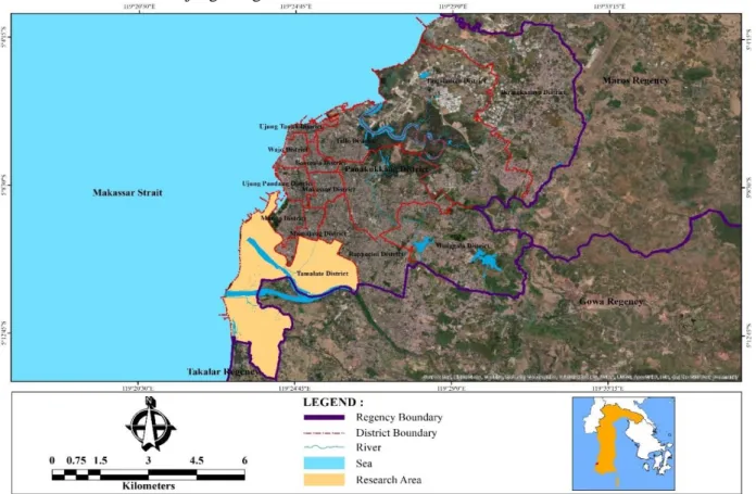
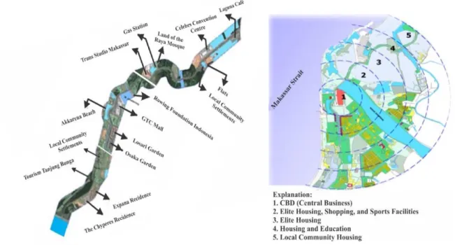
ETHODSThe research approach used in this study was sequential explanatory, which is a combination of quantitative and qualitative approaches in sequence. Qualitative research is used to build hypotheses based on phenomena that develop in the field. In contrast, quantitative methods are descriptive, comparative, and associative. The data collection techniques used in this study include observation, in-depth interviews, questionnaires, field notes, and documentation. In-depth interviews were used to gather information related to the development of the new Tanjung Metro area. This information was supported by observations that included: (i) characteristics of new urban areas, (ii) increase in population, (iii) spatial expansion and spatial patterns of new urban areas, (iv) changes in land use, and (v) growth of new urban areas. Research locations are shown in Figure 1.
Figure 1. Metro City new town area, Makassar City: Makassar as a research object In accordance with the focus of the study, the
data sources in this study are; (i) to obtain spatial transformation data working as a determinant of the development of the new city of Metro Tanjung Bunga Makassar, the data source is the intensity of land use, spatial patterns, transportation systems, facilities and
infrastructure as well as the economic growth of the new city area. The data was obtained through field observations and documentation, (ii) to obtain data on spatial expansion relationships, land use changes and population growth to the growth of the new city area of Metro Tanjung Bunga Makassar, the source of the data was the
spatial dynamics of the new city area, population growth , land use and development policies for the new Metro Tanjung Bunga city area from the Makassar City Government obtained through documents, surveys and in-depth interviews. From this data, a descriptive situation, event and observable behavior were carried out in detail.
The sample in this study was determined by purposive method, in which case the researcher determined the sample based on population specific characteristics, in accordance with the research objectives to be achieved. Determination of the sample is based on considerations: (i) the population has been determined since the beginning of the study, (ii) the sample is determined based on certain characteristics based on the main characteristics of the population, and (iii) the sample determined in this study is 400 households located in 10 villages in new city area Metro Tanjung Bunga. The method of selecting respondents was carried out in a way, the researcher went directly to the research location. The goal is to understand the situation and conditions that develop in the field. The determination of key informants in this study was used to collect qualitative data.
Determination of informants, done by snowball, means that researchers determine the people who can be interviewed based on information provided by residents, who can provide good information about the condition of
the development of the new city area Metro Tanjung Bunga. As an informant the researcher established one of the community leaders. Furthermore information from the informant is then passed on to other community leaders who can be interviewed, until the information provided has gotten the same picture. This informant is called by the researcher as the perpetrator in the phenomenon under investigation.
Quantitative data is collected from respondents or research samples. The sample is determined by purposive sampling technique based on certain characteristics. The characteristics referred to by the researcher are that the sample must be residents who are in new urban areas, are married, live or have not moved for at least 5 years, and know the condition of the local area. The characteristics stated are used by researchers in determining respondents. The results of filling out the questionnaire were analyzed using non-parametric statistics especially the percentage analysis based on frequency numbers.
n = n/Nd2 + 1 (1) where:
n = sample N = population
d = error rate (0.5) or 5% of the 95% confidence level.
Table 1.
Number of respondents assigned, in the New Metro City area of Tanjung Bunga, Makassar City
Number Urban district Population (head of family) Sample (head of family)
1 Mangasa 10.348 70 2 Parang Tambung 9.749 60 3 Tanjung Mardeka 2.216 20 4 Barombong 3.105 30 5 Maccini Sombala 5.185 45 6 Jongaya 3.932 35 7 Mannuruki 3.583 30 8 Pa'baeng-Baeng 5.059 45 9 Balang Baru 4.018 40 10 Bungaya 2.230 25 Total 49.425 400
Observations are observations made by researchers in the field. In this observation the researcher always relates to two things that are information and context. This means that the researcher will record what happened in the community located in the new city area and relate the incident to the dimensions of time and place. From this information and context, the researcher then draws a meaning from the events observed in the field. Information collected through observation is in accordance with the questions raised in in-depth interviews and questionnaires,
among others; characteristics of new urban areas, population potential, spatial expansion, spatial activity patterns, changes in spatial use, land use, and the growth of the new Metro Tanjung Bunga city area.
The survey in this study, using a questionnaire instrument. The questions formulated in the questionnaire were based on the results of preliminary interviews with several community leaders, observations and documentation obtained previously and concepts related to the research objectives. The targets of this research are
residents located in the new city area of Metro Tanjung Bunga, Makassar City. The questionnaire in this study was used for two functions: (i) descriptive, and (ii) measurement. The purpose of using the questionnaire is to provide a description of some characteristics of individuals, or groups of people. In this case, the relationship between spatial expansion, land use change, and increasing population to the growth of new urban areas and the sustainable development of the Metro Tanjung Bunga City in Makassar City by using a list of questions, both structured and unstructured previously compiled.
Structured interviews using questionnaires conducted by researchers are used by asking questions to respondents based on the questions in the questionnaire. The questionnaire was not submitted to the respondent but was guided by the researcher. Questions raised in the questionnaire focus on education level, social stratification, type of work, job specifications and economic effort, income level, land use conditions, community institutions, and land tenure structure. The selection of respondents was carried out by field staff who were both as enumerators. The completion of the questionnaire was facilitated by the enumerators who had been selected previously. The selected enumerators are based on considerations, namely those who have the ability to collect data, be close to the community, and understand the socio-cultural conditions of the respondents at the study site. Before carrying out their duties in the enumerator field, they were first given instructions and exercises to fill in the questionnaire and techniques for conducting interviews with respondents.
The questionnaire was distributed to the new city area of Metro Tanjung Bunga, which is located in Tamalate Sub-District, Makassar City. The criteria for the actors who fill out the questionnaire (respondents) are citizens who are married, at least live permanently or do not leave the place for a period of 5 years. Data frequency values, which are collected through surveys using a questionnaire and conducted by enumerators. Next, it is processed using a frequency table and using percentage analysis. The results are discussed qualitatively through interpretation of meaning for expression, which in the end this research can be more in-depth. Furthermore, focus group discussions are held to provide convenience and opportunities for researchers to build openness, trust, and understand respondents' perceptions, attitudes, and experiences. In this case the FGD was carried out through discussions that were carried out
systematically and directedly related to the conditions and situation of the community. FGD in this study was conducted 3 times. The focus of FDG is done more towards increasing the role of the community in the development of the new urban area of Metro Tanjung Bunga.
The document is a record of events that already apply. Thus, in this study, using various documents related to the situation and condition of the new city area of Metro Tanjung Bunga. The documents referred to include; land ownership status, population data, and data on urban area development programs to be implemented as well as other documents related to the research objectives. Secondary data collected by researchers for the purpose of completing the analysis include; Makassar City in Figures 2019, Districts in Figures 2019, and documents on the concept of developing the new city area of the Metro Tanjung Bunga Bappeda Makassar City. All information obtained by researchers in the form of documents is called secondary data. Therefore, in this secondary data collection, the technique that researchers used was documentation technique. This means that the data obtained by researchers are not directly obtained from the first source but at the second source.
The data analysis stage in this research is aimed at formulating basic concepts and data analysis. In this process several things that researchers do, namely: organizing data, from data that has been collected, among others; field notes and researcher comments, pictures, photos, documents in the form of reports, biographies, and so on. The job of data analysis in this case is to organize, sort, group, code, and categorize. Organizing data is done for the purpose of finding themes related to the substance of the theory used. There are two processes of activities carried out by researchers in data analysis. First, conducting qualitative research in which data collected through observation and in-depth interviews are then analyzed. Second, carry out quantitative research, in this case the researcher collects information on the research object using a questionnaire instrument. At this stage the main tool used as information is a questionnaire filled out by respondents, then an analysis is conducted. In this study relies more on a qualitative approach as a cross-check tool for data collected through questionnaires. In-depth interviews were conducted with informants, for the purpose of comparing answers and asking for detailed explanations from the respondents interviewed. For example in the questionnaire questions asked how far the intensity of their relationship,
especially those directly related to social ties and the principles of values and norms that are still carried out together in a unity of community group ties. Through this informant, the researcher will ask for a detailed explanation regarding the frequency of patterns of social relations and bonds between individuals in a group.
Quantitative approach, used to explore information through several questions that have been compiled and given alternative answers. The questions compiled by researchers in the questionnaire were based on initial orientation in the field. That is, researchers are trying to explore more about the conditions and characteristics of the people who inhabit the new urban area of Metro Tanjung Bunga. Data analysis is carried out in the field at the time of data collection, separates information into categories, makes information in a story, and presents writing qualitatively. Questionnaires in this process are used to help determine the conditions and characteristics of the community in general. In the initial stages the data collected from the interview and observation methods and secondary data are then analyzed using an emic and ethical approach. That is, researchers conduct data reduction activities and data presentation in accordance with the aims and objectives of the study. Furthermore, collecting data, related to social relations, economic enterprises, community institutions. This means that the interview approach is strengthened by observation at the research location.
Data analysis is done by combining qualitative and quantitative data analysis. That is, the steps used for qualitative research at the same time also used quantitative research. At the time of interpretation or analysis, each data is carried out reduction, namely for qualitative data categorization and quantitative data, descriptive statistical calculations and path analysis are
performed. The two data are then performed triangulation or between methods. This means that the data obtained using a questionnaire will be explored deeper through two methods, namely qualitative and quantitative. This merger is more to strengthen the validity of the results of the analysis. Furthermore, the intended data reduction is grouping or categorizing data according to the scope of the study. Likewise with the questionnaire, all questions made refer to the focus of the study.
The use of path analysis refers to variables, namely (i) X1 exogenous independent variable (spatial expansion), (ii) X2 exogenous independent variable (land use change), (iii) X3 exogenous independent variable (population growth), (iv ) Y endogenous dependent variable (growth of new urban areas), and (v) Z endogenous dependent variable (sustainable development of new urban areas). Path diagram using structural equation:
Y = PYX1 + PYX2 + PYX3 + e1 (2)
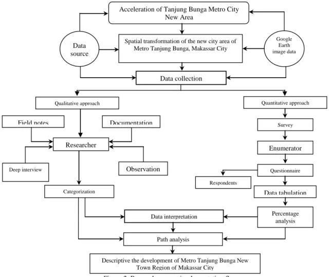
Path analysis is used with consideration: (i) research metric data are measured based on interval scale, (ii) exogenous and endogenous dependent variables refer to multiple regression models, while intermediate variables refer to mediation models and the combined mediation and multiple regression models which are complex models , (iii) the relationship between variables is one-way, and (iv) cause and effect is based on the theory that is, there is a relationship or correlation between natural resource management, economic empowerment, community capacity building towards increasing the productivity of economic enterprises and the sustainability of community-based watershed ecosystems. The flow of the research process in the following figure.
Figure 2. Research process implementation flow
III. R
ESULT ANDD
ISCUSSIONUntil the end of 2019, the area will be built in the new urban area of Metro Tanjung Bunga, Makassar City, occupying an area of 1,716.94 hectares and is dominated by commercial economic activity functions. This fact illustrates that the orientation of agricultural production is no longer the main activity of local communities. Note how agriculture in these areas can supply key services derived from its environmental, social, and economic functions in response to the consumption-oriented requirements of urban society [30].
Spatial transformation in the new city area of Metro Tanjung Bunga Makassar City has an
impact on changes in spatial attributes in the urban suburbs of Metropolitan Mamminasata. Spatial attributes of the city that develop towards the industrial model will encourage the formation of the city as a center of creativity and culture that reflects the vitality for various socioeconomic opportunities [31], [32].
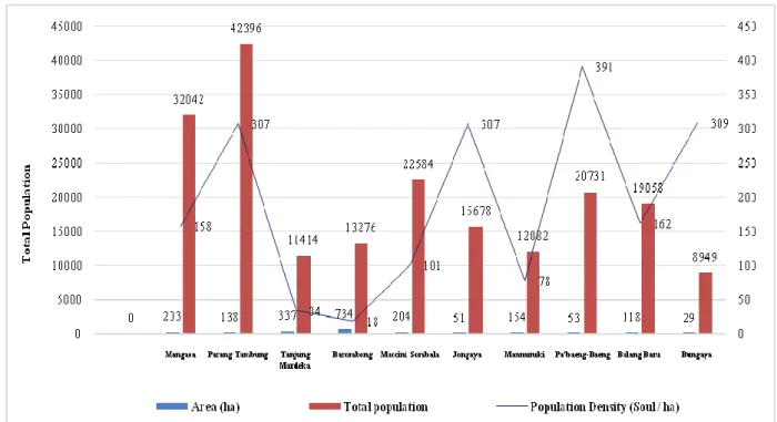
The growth of the population of the new Metro Tanjung Kota new city area, until the end of 2019, showed a fairly high increase, with an average growth of 1.45 percent per year. This figure is higher than the population growth of Makassar City as a whole. The number and population density of the Metro Tanjung Bunga new city area is shown in Figure 3.
Descriptive the development of Metro Tanjung Bunga New Town Region of Makassar City
Field notes
Qualitative approach
Researcher
Deep interview Observation Documentation Data interpretation Categorization Path analysis Quantitative approach Survey Enumerator Questionnaire Data tabulation Respondents Percentage analysis Data collection Data source Google Earth image data
Acceleration of Tanjung Bunga Metro City New Area
Spatial transformation of the new city area of Metro Tanjung Bunga, Makassar City
Figure 3. Number and density of Metro Tanjung Bunga new city area residents Several things that can be explained are
related to the population of Metro Tanjung Bunga new city area, namely (i) the largest area is located in Barombong Village with an area of 734 ha, while the smallest area is located in Bungaya Village with an area of 29 hectares; (ii) the largest number of family heads are located in Mangasa Village, 10,348 families, while the lowest number of family heads is in Tanjung Merdeka Village, 2,216 families; (ii) the highest population is in Parang Tambung Village, 42,396 inhabitants, while the lowest population is located in Bungaya Village, 8,949 inhabitants; and (iv) the highest population density is located in Pa'baeng-baeng Kelurahan, with a density of 391 people/hectare, while the lowest population density is located in Barombong Kelurahan, with a density of 18 inhabitants/hectare. This figure confirms that as many as 8 villages, including the category experienced a very fast acceleration, and 2 villages, namely Barombong and Tanjung Merdeka, are areas of development of the Metro Tanjung Bunga new city in the future.
Changes in spatial use due to the conversion of productive agricultural land in the new urban area of Metro Tanjung Bunga are positively associated with suburbanization and gentrification in the urban suburbs of Metropolitan Mamminasata. This means that the new urban area of Metro Tanjung Bunga is closely related to capital flows and investment in
urban development, among others; large-scale settlements, marine tourism, trade and shopping centers, infrastructure, hotels, services, education, and health and other urban activities. Increased activity caused a very intensive spatial interaction that took place in the Metropolitan Mamminasata urban system and became a driving force for the mobilization of migrants from the surrounding area to the new Metro Tanjung Bunga city area to settle and develop businesses in economic activities. The physical, economic, and social spatial interactions then developed towards urban conurbation and the connectivity of the surrounding urban and rural infrastructure systems.
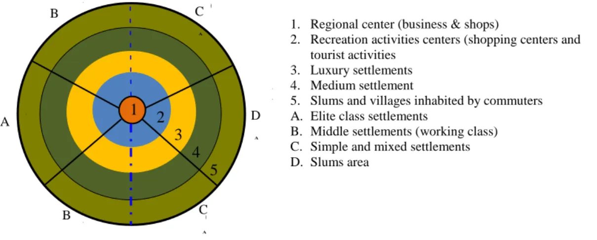
Interaction between regions is reflected in the state of transportation facilities and the flow of people, goods, and services [33], [34]. The results confirm that the allocation of land allotments and changes in spatial use dominated by commercial functions and large-scale settlements led to the development of the new urban area of Metro Tanjung Bunga, Makassar City, towards the poles of economic growth and urban agglomeration. This process then impacts the formation of new service centers to support the function and role of Makassar City as a core city in the Metropolitan Mamminasata urban system. The hierarchy service center for the new urban area of Metro Tanjung Bunga is shown in Figure 4.
Figure 4. Service structure of Metro Tanjung Bunga new city area The hierarchy of service centers that were
built and formed in the Metro Tanjung Bunga new city area (Figure 4) shows a very basic difference based on settlement grouping between migrants and local communities that have long inhabited the Tanjung Bunga Metro area. Interpretations that can be proposed are related to these differences are: (i) the activity center area is characterized by the existence of a business center, which consists of shopping centers within 250-500 meters of elite residential locations, (ii) recreation center developed is part of the urban function in a framework to support economic growth in new urban areas, (iii) luxury to very luxurious settlements are dominantly inhabited by class elites and easily accessible from all directions, (iv) dominant middle settlements are inhabited by workers in business centers and consist of professional groups with specific expertise, (v) the outer portion of the area consists of slums that are inhabited by local and rural communities that are inhabited by
commuters who depend on the core city of Makassar.
The vital function of cities is to provide affordable infrastructure and institutional environments that enable migrants and other marginal urban communities to contribute to urban prosperity and problem-solving with their entrepreneurial skills, networks, and minds [35].
Differences in characteristics that develop in the new city area of Metro Tanjung Bunga Makassar City have a tendency toward dualism based on a developing economic system. On the one hand, a formal economic system is developed by the owners of capital and on the other hand, a non-formal economic system is developed by the local community. The informal sector can provide social capital, promote local economies, create jobs, and provide the needed economic shift toward a sustainable future [36]. Changes in spatial use over the 2010-2019 time period is shown in Table 2.
Table 2.
Changes in spatial use of new cities in Metro Tanjung Bunga, period 2010-2019
Number Space utilization in
2010 Land area (ha) % Space utilization 2019 Land area (ha) % Information
1 Trade/commercial 7,56 0,80 Trade/commercial 242,12 14,10 Increase 2 Education 1,50 0,16 Education 15,89 0,93 Increase 3 Settlement 122,51 12,93 Settlement 1.145,82 66,74 Increase 4 Health 1,50 0,16 Health 1,5 0,09 Permanent 5 Tourism 11,62 1,23 Tourism 40,65 2,37 Increase 6 Office space 1,16 0,12 Office space 9,56 0,56 Increase 7 Sports facilities 3,20 0,34 Sports facilities 14,56 0,85 Permanent 8 Social facilities 11,00 1,16 Social facilities 30,39 1,77 Increase
9 Hotel - - Hotel 10,12 0,59 Increase
10 Rice fields and mixed gardens
160,00 16,88 Rice fields and mixed gardens
25,15 1,46 Reduced
11 Pond 108,00 11,39 Pond 79,14 4,61 Reduced 12 Empty land 519,76 54,84 Empty land 102,04 5,94 Reduced
Table 2 shows the intensity of the conversion of productive agricultural land toward the development of urban socio-economic activities in the new city area of Metro Tanjung Bunga,
Makassar City. Two interpretations related to the process can be raised, which are as follows:
1. Settlement is the most dominant use of space, with an increase from 122.51 hectares in
2 3 4 5
1
1. Regional center (business & shops)
2. Recreation activities centers (shopping centers and tourist activities
3. Luxury settlements 4. Medium settlement
5. Slums and villages inhabited by commuters A. Elite class settlements
B. Middle settlements (working class) C. Simple and mixed settlements D. Slums area B C A B C D A B B C A C A D A 2 3 4 5 1
2010 to 1,145.82 hectares, representing an addition in area of 1,023.31 hectares in 2019;
2. Trade/commerce has increased; in 2010, it only occupied 7.56 hectares of land, then experienced an increase of 242.12 hectares in 2019. This means that, during the 10 years of increased economic activity, the new city area of Metro Tanjung underwent significant changes, with the addition of 234.56 hectares;
3. Tourism activity originally used only land area of 11.62 hectares in 2010, then experienced an increase of 40.65 hectares in 2019, or had an expansion of 29.03 hectares.
These three developing activities positively contributed to the increase in land values in the new urban area of Metro Tanjung Bunga. Urban land development results from cooperation and competition between local government and enterprises, with a focus on multiple political and economic factors [37].
The fact that the field is found shows that the spatial transformation of the new city of Tanjung Bunga Makassar Metro is influenced by two main factors, namely (i) the process of spatial physical development centrifugally, and (ii) the development of a centripetal spatial. Centrifugal spatial development becomes a determining factor in the increasing area of new cities and population mobility toward the surrounding suburbs. This means that, in the future, it will be necessary to control the spatial use that is developed in the direction of a compact, comfortable, and efficient unified urban system. Changes in land use in the direction of urban housing, industry, trade, and increasing population cause land price increases and affect the characteristics of the surrounding urban and rural areas [38], [39], [40], [41]. Thus, the development of the new city area of Metro Tanjung Bunga, represents a process of
expansion and addition of Makassar City space toward the periphery, occurring horizontally by occupying spaces that are still empty. The direct effects of the process are a decrease in the quality of the environment and changes in the spatial structure, spatial patterns, typology, and morphology of the suburban Metropolitan Mamminasata urban area.
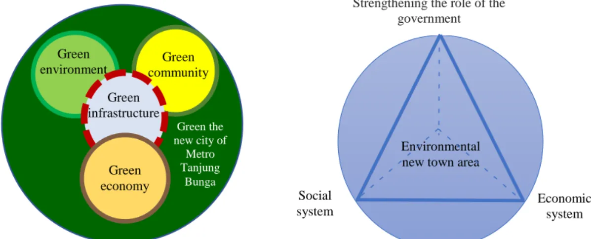
A. Determinants of the Development of the Tanjung Bunga New Town Area
Changes in the spatial use and conversion of productive agricultural land toward the functions of economic activities cause formal and non-formal economic activities to develop in the new city area of Metro Tanjung Bunga, Makassar City. These changes are positively associated with changes in the means of production toward urban space reproduction [42], [43]. This means that the new urban area of Metro Tanjung Bunga, Makassar City, has a strategic role in integrating the system on a broader spatial scale due to the polarization effect of the core city spatial in the Metropolitan Mamminasata urban system. The growth of the population requires the continued search for residential space; the urbanization of natural lands is an inevitable process, but that process does not have to be one that is accomplished without regard for environmental quality [44], [45]. The economic polarization that developed in the new urban area of Metro Tanjung Bunga in Makassar City has a direct influence on increasing the construction of new settlements by changing the characteristics of the surrounding rural areas and developing toward integrating the Metropolitan Mamminasata urban activity system. The spatial physical development of the new city area of Metro Tanjung Bunga is shown in Figure 5.
Figure 5. Linear and concentric spatial physical development new city area Metro Tanjung Bunga The development of linear and concentric
spatial physical (see Figure 5), in the new city area of Metro Tanjung Bunga is the development of the area of the region to the awakened areas that blend in a compactly, through the accumulation of commercial activities and its central point is characterized by the existence of shopping centers in the Graha Tata Cemerlang (GTC) Mall. Spatially, the development in a linear and horizontal direction affects the expansion of the area of the new city area by changing the spatial attributes of the surrounding countryside. The triggering factor for horizontal development is the existence of the main road corridor along the 23 km from the direction of the core city of Makassar, across the new Metro Tanjung Bunga city area and heading toward the Regency of Gowa and the District of Takalar. This means that the function of the main road corridor, in addition to facilitating population mobility, contributes positively to the connectivity of the surrounding urban system. In this case, the new city area affects the integration of the urban system, ease of movement and circular migration from the surrounding rural areas to the core city of Makassar. The demand for urban labor has increased due to
developments in the city and rapid economic growth in the private sector [46].
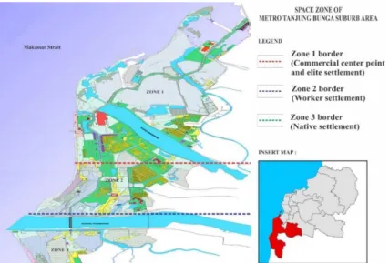
Concentrically spatial physical development, characterized by the accumulation of dominant commercial activities located at the center of the new city area, has an effect on increasing building density, changing land values, and increasing daily traffic circulation. The results of the field confirmation show that the accumulation of activities at the center of the new city area has an effect on the high traffic generation and congestion during rush hour, that is, in the morning, afternoon and evening. This means that the dynamics of the development of the new Tanjung Metro city area are positively associated with increasing vehicle pollution and decreasing environmental quality. Urban growth has caused many environmental problems, especially urban sprawl, which leads to a loss of green open spaces and an increase in traffic and energy consumption [47]. Furthermore, spatial zonation that develops has an impact on changes in typology, morphology, spatial patterns, and connectivity of urban transportation systems. Zoning of the new urban area of Metro Tanjung Bunga is depicted in Figure 6.
Figure 6. Spatial zone of new metropolitan areas of Metro Tannjung Bunga Three categories of spatial zones were formed
(Figure 6), which are as follows: (1). The main zone, inhabited by residents with high socioeconomic status, is characterized by complete socioeconomic services and is dominated by migrants, comprising the ruling elite, professionals and business people. This group is expansive migrant population, consisting of capital and business owners in the new Metro Tanjung Bunga city area. This group predominantly controls land, has political power, a high level of income, and occupies a luxurious to very luxurious residential facility in the new urban area of Metro Tanjung Bunga. (2). The zone between zone 1 and zone 3 is a location that is inhabited by groups of workers, who are migrants who enter and blend in with local residents, consisting of employees who work in businesses of economic activities, namely in the trade business, malls, shops, shops, tourism , hotels and other economic ventures. This group has a much better income than zone 3. (3). The outermost zone (zone 3) is inhabited by local communities of low socioeconomic status. These groups are generally houses on stilts, are very simple, and residential facilities tend to develop toward slums, characterized by the existence of poor people and limited infrastructure services. As far as the physical aspect is concerned, the slum is usually characterized by a crowded and unhealthy environment, low-quality buildings, and lacking public infrastructure and facilities [48].
The residential area that developed in the new Metro Tanjung Bunga city area, shows spatial segregation in relation to the use of space between zones, and the mixing of planned (formal) and traditional (informal) settlements, as well as experiencing rapid population growth, while the center of the region is undergoing
population stagnation and decline as part of the Metropolitan Mamminasata urban mega-urbanization process [49], [50], [51]. Field facts found, show that the characteristics of settlements that develop based on building types tend to form new settlement clusters based on economic classes towards differences in stratification and social status between migrants and local communities [52]. Suburbanization of poverty caused not only by direct moves but also by broader indirect and exclusionary processes attributable to the increasing unaffordability and inaccessibility of central city locations [53]. This broader process reflects the changing geography of urban regions marked by shifting socioeconomic divides [54].
Increased capital flows and investments towards gentrification in the new urban area of Metro Tanjung Bunga, have repositioned the role of land economic values that are no longer based on the extent and potential of agricultural products but have undergone changes based on the function of developing economic activities. The facts found show that the price of land before the construction of the new urban area of Metro Tanjung Bunga was in the range of Rp.50,000, - Rp.100,000, - which was assessed based on the area and productivity of agricultural land. Furthermore, since the period of 2017 until now there has been a significant change based on the value and productivity of the land economically with land prices between Rp. 3,500,000 - Rp. 5,000,000. This fact confirms that land and space in the new urban area of Metro Tanjung Bunga have experienced a shift in values and functions, as well as in terms of ownership, which is dominantly dominated by local communities and then shifted and controlled by capital owners, ruling elites, and capital owners. This means that the existing space and land is considered a
commodity that will be reproduced and traded, and its authority is largely determined by the ownership of capital and income [55], [56]. Dengan demikian, semakin dekat jarak lokasi permukiman terhadap pusat kegiatan utama dan fungsi-fungsi kegiatan ekonomi maka nilai dan harga lahannya semakin tinggi demikian pula sebaliknya. As agglomeration grows and gets stronger, land values increase, and poor initial settlers are derelict from the ease of the spatial layout on which they relied [57].
Land productivity in the new city area of Metro Tanjung Bunga Makassar City is very much determined by its location based on the function of economic activities. The dominant development intensity towards the functions of economic activities and large-scale settlements is characterized by the ability of economic enterprises to positively associate with inequality in spatial control, differences in stratification, and social classes between migrants and local communities. Six things that can be explained based on spatial zones and spatial functions that develop in the new Metro Tanjung Bunga city area, namely (i) changes in land use, (ii) changes in housing building characteristics, (iii) changes in residential patterns, (iv) interactions social and social adaptation between migrants and local communities, (v) gentrification and suburbanization of the periphery and (vi) physical, economic and social segregation. These six things show that the allocation of built space based on spatial zones in the new urban area of Metro Tanjung Bunga is positively associated with differences in accessibility, population mobility, and socio-economic disparity, and the trigger factor is expansive influx of migrants who have stronger economic status capabilities, when compared to the local community. The
importance of cultural sustainability as a driver of community-driven sustainability practices, but it also shows how these drivers are closely related to efforts to address the sustainability of organizations and individuals [58].
The fact of the field found shows that the development of large scale settlements built by developers and dominantly inhabited by upper middle class with models and types of luxury and very luxurious residential. On the other hand shows the existence of slums that are inhabited by local communities with the type and model of residential houses on stilts and developing towards slums. Indicators used to assess the existence of slums in the new Metro Tanjung Bunga city area, namely (i) the occupancy and aesthetics of the building does not meet the health requirements inhabited by low-income people, (ii) inability to access spatial economic resources, (iii) scarcity of housing facilities and infrastructure and infrastructure services, (iv) flood-prone due to inadequate drainage network infrastructure, (v) environmental pollution due to inadequate sanitation support and waste facilities, (vi) prone to fire threats, due to inadequate road network , and (vii) accessibility is quite low due to a patterned and very limited road network system. The growth of slums was not a wholly organic development that occurred within the domestic conditions of a country, rather it is one of the results of globalized, neoliberal capitalism [59]. Thus, spatial transformation and changes in spatial use in the new urban area of Metro Tanjung Bunga have an impact on physical, economic, and social segregation. The typology and characteristics of the slum that developed in the new urban area of Metro Tanjung Bunga in Figure 7, follows.
Figure 7. Slum residence in new metropolitan areas of Metro Tanjung Bunga Spatial engineering and the inability of local
community access to the economy have an impact on the development of slums (Figure 7). The slums are caused by internal conditions, namely cultural factors, place of work, place of birth, length of stay, house investment, type of
building, and external factors, namely land ownership and government policies [60]. This means that institutional discrimination against community groups related to land ownership and the right to use and benefit is the main reason for the development of informal settlements [61].
This fact confirms that the government's support for the poor tends to be neglected in the implementation of the new Tanjung Tanjung Metro area. UN Sustainable Agenda 2030 appreciates the increasing challenges posed by rapid urbanisation including issues of urban sustainability, increase in informal settlements (slums, squatters, shanty towns) and resilience to future urban environmental stresses [62].
There are three kinds of expressions that appear related to the spatial transformation in the new urban area of Metro Tanjung Bunga, namely (i) social rank, this condition is indicated by changes in the economic status of society to become social layers arranged based on specialization and social achievements, (ii) urbanization , indicated by changes in family status that increased from traditional family lifestyles to urban lifestyle families, and (c) segregation, has a tendency towards changing the ethnic status of certain groups based on "ethnic city" characterized by differences in ownership of residential facilities and wealth . Changes in relations and patterns of work relations of traditional agrarian societies then undergo a change in the direction of contractual work patterns of urban industrial societies [63]. The direct impact of social change on local communities is reflected in social solidarity, in this case the change in mechanical social solidarity towards organic solidarity.
The facts found in the field show that the inability of local communities in the process of adaptation to environmental change stimuli due to spatial engineering in the development of Metro Tanjung Bunga city area has led to the existence of local communities in marginal positions. This fact is measured based on indicators of ownership of residential facilities
and difficulties in obtaining decent work, so that it is categorized as urban poor. Other facts found in the field show that the work orientation that can be achieved by local communities is divided into two main categories, namely (i) formal urban activities, namely local communities who are able to obtain jobs as security officers in luxury settlements built by developers and office boys in commercial economic activities, and parking attendants on the functions of developing commercial economic activities, (ii) urban informal activities, namely as domestic servants in elite housing, street vendors, construction workers, and vegetable vendors. Thus, the dynamics of the development of the new Tanjung Metro city area has an impact on differences in the hierarchy of meeting the needs of the local community.
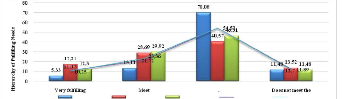
Hierarchy of meeting the needs of the local community of the new city of Metro Tanjung Bunga, measured using five main indicators, namely (i) physiology: covering the needs of clothing, food, shelter, and individual welfare, (ii) security: includes security in working physical and future guarantees, (iii) social: including needs accepted by others, a sense of respect, being able to excel, and participating in an activity, and (iv) self-esteem: include internal appreciation factors such as autonomy, and achievement; and external appreciation factors such as status, recognition, and attention, and (v) self-actualization: the drive to become someone according to his abilities; includes growth, achieving one's growth and self-fulfillment [64], [65]. To support this fact, a hierarchy of fulfillment of needs is measured based on the perception of local communities that are still in the new urban area of Metro Tanjung Bunga and the results in Figure 8, below.
Figure 8. Hierarchical graph of fulfilling the needs of local communities in new of Metro Tanjung Bunga Interpretations that can be proposed (Figure 8),
namely: First, the relationship of spatial transformation and changes in spatial use to the fulfillment of the physiology of local communities illustrates that only 5.33% of local
communities answered very fulfilling, 13.11% answered fulfilling, 70.08 % answered did not meet and 11.48% answered did not meet. This fact confirms that spatial transformation and rapid changes in spatial use indicate differences
in meeting the physiological needs of local communities. Secondly, the relationship of spatial transformation and changes in spatial use to the fulfillment of a sense of security of local communities, illustrates that 17.21% of local communities answered very fulfilling, 28.69% answered fulfilling, 40.57% answered unsatisfied, and 13.52% answered does not meet the. This fact shows that spatial transformation and changes in the use of space are positively associated with fulfilling a sense of security for local communities. The results of the field confirmation illustrate that security is only felt by local communities who are able to work on socio-economic activities that develop in the new urban area of Metro Tanjung Bunga.
Third, the spatial transformation and changes in the use of fulfilling social relations, obtained a picture of 12.3% of the local community states that it is very fulfilling in terms of social relations between migrants and local communities and goes well, then 29.92% answered fulfilling in this regard social relations are built if there is a need, 46.31% answered not fulfilling, and 11.48% answered not fulfilling. This fact confirms that after being confirmed in the field it illustrates that social relations that work well only take place in the neighborhood of local communities and specifically infiltrative migrants. The pattern of positive relationships between infiltrative migrants and local communities is influenced by openness between communities by building social relations that are mutually beneficial for the purpose of improving their welfare and occupancy in a single environmental unit.
Fourth, spatial transformation and changes in utilization to meet the needs of the local community's self-esteem. As many as 11.07%, the local community answered that they were very fulfilling, 21.72% answered that they were fulfilling and were proud as citizens in the new urban area of Metro Tanjung Bunga, 54.51% answered that they did not, and 11.89% answered that they did not. These results confirm that, pride as citizens in the new urban area of Metro Tanjung Bunga is only felt by a small portion of the local community. Fifth, spatial transformation and changes in spatial use to the needs of self-actualization of local communities. As many as 10.25%, the local community answered very fulfilling, 23.36% answered that it fulfilled, 54.51 answered it did not meet, and 12.70% answered it did not.
The five aspects analyzed show that spatial transformation and changes in spatial use do not directly affect the existence of local communities in the new urban area of Metro Tanjung Bunga.
Positive contributions only occur in social relations between local communities and infiltrative migrant populations. Whereas four other aspects tend to weaken towards meeting the needs of the local community. Furthermore, the ability of the community to survive in an urban environment is closely related to the ability to adapt or modify their behavior in response to the availability and distribution of resources, so decision making is needed [66].
The relationship between decision making as a strategic group, what is needed in relation to the existence of local communities in the Metro Tanjung Bunga area is how to integrate government organizations with various community needs and demands [67]. This means that spatial transformation and changes in space use are positively associated with marginalization and poverty in local communities and are the impact of the development of new urban areas. Furthermore, the spatial transformation and changes in the spatial use of the new Metro Tanjung Bunga city area, illustrate that a particular land parcel has the potential to affect adjacent land parcels and extend towards the surrounding area within the Mamminasata Metropolitan urban system. There are two stages of the process in the dynamics of the development of new urban areas that can be explained, namely (i) the dominance of economic activity over the surrounding rural areas, (ii) the integration of activity patterns in the Metropolitan Mamminasata urban system. Morphological changes are illustrated through changes in urban structure and city shape on the scale of metropolitan space [68], [69]. The facts found in the field show that the construction of large-scale settlements and the functions of regional-scale economic activities in the new urban area of Metro Tanjung Bunga have an impact on the unification of several surrounding urban areas and positive associations on the poverty of local communities. The emergence of community poverty, in addition to being caused by the process of urban involution, powerlessness in accessing economic resources, is also a result of the increasingly strong control of land by capitalists [70].
B. Impact of Spatial Expansion of New City Metro Tanjung Bunga
The spatial transformation and changes in spatial use of the new Metro Tanjung Bunga city area, are the determining factors for the expansion of the Makassar City urban area towards the Metropolitan Mamminasata urban periphery. The direct impacts of the process are
(i) increasing the number and density of population, (ii) the development of urban activities in the vicinity of new urban areas, and (iii) connectivity of urban activity and infrastructure systems. These three things are positively associated with the increased mobility of goods and services transportation and population mobility. Mobility inequality, since access to citywide urban functions is highly dependent on the access to private vehicles [71]. The field facts found show that along the road lane that develops in a long way is a developed area, which is dominated by the functions of commercial activities. Urban longitudinal pathways have controlled the growth of settlements and non-residential buildings in such a way that they form concentrations of buildings with an extended spatial distribution far greater
than the widening distribution [72]. Furthermore, the flow of transportation movements, marked by an increase in the volume of motor vehicles is quite high from the new city area Metro Tanjung Bunga towards the center of Makassar City. The impact of the transportation system connectivity has led to urban growth around new urban areas and its tendency towards spatial use patterns that are single, scattered, tend to jump, and degradation of the quality of the urban environment. This fact confirms that spatial transformation and changes in spatial use are a recurring symptom in the new Metro Tanjung Bunga city area in the Mamminasata Metropolitan urban system. The impact of transformation and changes in spatial use of the new Metro Tanjung Bunga city area in Table 3, follows.
Table 3.
Impact of spatial transformation in new areas of Metro Tanjung Bunga to the Mamminasata Metropolitan urban system
No Impact Parameter Interpretation
1 Urban system Spatial structure Changes in the structure of urban services are characterized by economic growth poles.
Accumulation of urban activity centres towards the suburbs of Mamminasata Metropolitan
Spatial pattern Changes in agricultural cultivation activities towards industrial areas on the outskirts of Mamminasata Metropolitan
Physical changes to the Mamminasata Metropolitan area due to the allocation of new space functions (houses, works, clans, likes and facilities and infrastructure).
Transport movement system
Increased mobility of goods and passenger transportation.
Increased volume of motor vehicles and traffic congestion. 2 Environmental
system
Ecosystem condition Environmental degradation and decreasing Green region coefficient (KDH) in the Mamminasata Metropolitan urban area.
Environmental damage due to pollution of soil, water and air. Land-use system Removal of productive agricultural land-use function.
Environmental damage due to pollution of soil, water and air. 3 Economic
system
Economic activities Inequality in mastery of space reproduction and urban dualistic (formal and informant) economic systems.
Changes in work relations from traditional economic systems towards urban modern economic systems.
Land value Changes in land sale value based on urban space functions.
The economic value of the land is oriented to the function of space and the market economy.
4 Social system Social structure Changes in social relations towards differences in modes of production and sharpening of socio-economic strata.
Changes in social status based on educational background, expertise, and skills.
Social mobility Differences in vertical and horizontal social mobility between immigrants and local residents.
Social mobility is characterized by the ability of capital, wealth, and develops towards segregation.
Social dynamic Social dynamics are very dynamic characterized by changes in the orientation of agricultural work to urban industry.
The social dynamics of immigrants and local residents develop in the direction of urban inter-ethnic segmentation.
The proposed interpretation is related to spatial transformation (Table 3), in the new city area of Metro Tanjung Bunga, Makassar City; that is; (a) changes in the urban system, in this case improving service structures in the new
Metro Tanjung Bunga new urban area characterized by the accumulation of socioeconomic activities, which tend to develop towards urban agglomeration through the creation of markets and the process of spatial