4
Copyright@SPSD Press from 2010, SPSD Press, Kanazawa
The Development of Code River Area in Yogyakarta as a Sustainable Urban Landscape Asset
acknowledging Local Traditional Knowledge
Bambang Soemardiono 1* and Ardhyasa Fabrian Gusma 2
1 Department of Architecture, Faculty of Civil Engineering and Planning, Institut Teknologi Sepuluh Nopember (ITS)
2 Department of Techincal Architecture, Gadjah Mada University
*Corresponding author, Email: [email protected]; [email protected] Received 13 December, 2013; Accepted 20 May 2014
Key words: Code River, Local Wisdom, River Banks, Sustainable Urban Landscape
Abstract: River Bank is an area which not only maintains the area’s ecological functions but also exists as a potential public space which can be promoted as a natural recreation area for individual or groups. Regarding the Government Decree Nu 38 Year 2011, the river area is described as an area which maintains the functions of the river, by supporting its morphology, protecting the area against flood, providing habitat for flora and fauna, conserving water, as well as ensuring good micro climate quality. Code is a unique river spreading from northern to southern parts of Yogyakarta, whose natural landscape functions, especially in the urban area (sections 3 to 6), are deteriorating. The aesthetical landscape quality is high in Gemawang district. However, in other urban areas such as Keparakan, Tegal Panggung, Terban and Wirogunan (belonging to section 3 to section 6), we still find slums and low quality river areas. Code River is the urban landscape asset of Yogyakarta. Concerning its essential functions, efforts should be taken to conserve this area. This is expected to enhance the performance of spatial planning, which can improve the sustainability of the ecosystem in the city and its ecological functions. In this paper, through identifying the problems in deteriorating landscape functions and quality, it is indicated that public participation is not included in the holistic concept. Through the exploration of the criteria for creating a development concept, public participation is included. Focusing on land use and visual landscape, the concepts of spatial land use along the selected urban area of the Code River are created to improve the performance of sustainable urban landscape assets through the acknowledgment of local traditional knowledge.
1. INTRODUCTION 1.1 Background
Urban landscapes are described as socio ecological systems where natural and social processes work together within the ecosystems (Andersson, 2006) and can be explored in respect of how cities developed over time and their relation to nature. The river bank is part of the urban landscape; it has ecological functions and plays a role as a potential public
space, it can also be promoted as a natural recreation resource for individual or group visitors.
Regarding the Government Decree Nu 38 Year 2011, the river area was described as an area 10 to 30 meters wide, depending on its depth. That declaration has the objective of not only maintaining the function of the river by supporting its morphology, providing flood protection and the habitat of flora and fauna, but also for conserving water through the maintenance of micro climates. Code River is a unique river, t spreads from northern to southern parts of Yogyakarta. If we look at the nine sections as determined by Yogyakarta government, it can be seen that section 4, 5 and 6 are located in the urban area (Figure 5). These sections include the districts of Gemawang, Keparakan, Tegal Panggung, Terban and Wirogunan. Recently, the functions of the natural landscape in Code River have been declining.
The river banks are neither aesthetically nor ecologically balanced.
Moreover, the land use in that area seems unplanned. The river bank in Gemawang shows highly aesthetic landscape quality, however, slum areas are still found throughout the entire urban area, such as in Keparakan, Tegal Panggung and Wirogunan. Those conditions result in the river area lacking in quality. For that reason it is essential to conserve and to revitalize the river area in order to support the existing famous district’s nodes, called Malioboro. Efforts should be taken in conserving the potential public space under the consideration that Code River is one of the important landscape assets of Yogyakarta waterfront. This could be achieved by increasing the performance of spatial planning and by facilitating the development and sustainability of the ecological functions of the city’s ecosystem.
The holistic concept of sustainable development should include three aspects, namely ecological, economic as well as social aspects. Since previous research has been concerned with those aspects only partially, this research makes an effort to deal with all three aspects by including public participation to overcome problems related to land use and the visual landscape. The first step will be to identify the problems in the urban river area of Yogyakarta, followed by an exploration of the criterion and development of the concept toward achieving spatial land use and landscape quality in the selected urban area, creating sustainable urban landscape assets.
Figure 1. Code River in urban areas (Tegalpanggung, Wirogunan, Keparakan) Source: Department of Public Work, Housing and Mineral Energy, Yogyakarta, 2011
Figure 2.The high aesthetical quality of the landscape is shown in the river area of Gemawang and the slum area and lack of high river quality.
Source: Soemardiono, B., 2012
Based in the context of the urban landscape, the problems can be identified as follows:
1) The functions of the natural landscape in the Code urban river area show a low quality, caused by the low aesthetical and ecological quality of the river banks as well as unplanned land use. Although the high aesthetical quality of the landscape can be seen, the potencies have not been explored yet. In addition, in the urban sections, slum areas can still be found.
2) Code River and its surrounding area have unique characteristics. In reality, however, it has not yet been explored as a potential asset of the urban landscape.
3) Previous research did not apply holistic concepts and public participation.
This research will focus on the urban area of Code River by considering potential tourist attractions and unplanned land use.
2. THEORETICAL REVIEW
2.1 River bank as waterfront area, public open space, nodes and element of sustainable urban landscape
Nicholin and Repishti (2003) thought that in recent years, the concept of landscape has undergone more changes than before. Tadao Ando in Nicholin and Repishti (2003) sought to achieve spaces that stimulate the human spirit, awaken sensitivity and communicate with the deeper soul. According to their research, this will reflect a new meaning of landscape. Rather than merely
“visible feature of territory”,its definition has extended precisely in order to accommodate the interaction between human activity and the environment.
Every physical, human, cultural, social, perceptive and economic element of a landscape have now become a part of the same notion. Currently, landscape architects work in many fields such as environmental planning, large-scale recovery for abandoned and residual areas, design of public spaces and parks, design for private gardens, as well as in art and photography. In addition Simonds and Starke (2006) stated that the work of the landscape architect is to help bring people, structures, activities and communities into harmonious relationship with the living earth, with the want to be “of the land”. Meanwhile, Turner (2009) has defined sustainable urban landscape as having an absolute balance between “environmental, economic and social needs”, which is cited by almost every landscape practice in England. In addition, Bergstrom, Elmqvist, et al. (2006) describe that urban landscapes constitute the future environment for most of the world’s human population. An increase in understanding of the urbanization process and the effects of urbanization at multiple scales is, therefore ensuring human well-being. Susilo (2006) mentioned that urban landscapes
have common characteristics, such as that the building and the urban space are not fit to human scale, that there are very few trees and vegetation in urban areas, and the land surface is full of buildings or structures with minimum open space and as a result it leads to insufficient spaces for water absorption and causes heat islands. Concerning the sustainability of recent and future land use, the environmental capacity and landscape character have to be considered. The changing of two aspects will be affected by social, economic, as well as environmental factors. Landscape planning is holistic because in planning all aspects, such as social, cultural, economic and aesthetics, must be integrated in line with the task of the landscape architect to help the community, to enhance urban landscape structure and to provide activities that lie in harmony with nature. Riverbanks as an urban landscape element play an important role in developing the unique landscape character of a city. For instance along Tsim Sha Tsui, Hong Kong, people can walk along the well-known promenades while enjoying the beautiful scene of waterfront buildings and other potentials views. In Singapore people enjoy the atmosphere of the river while observing the beauty of the landscape.
Figure 3.River Banks Tsim Sha Tsui, HongKong, Source: Soemardiono, B, 2011
Figure 4. River Banks in Singapore, Source: Soemardiono, B, 2006
Water is a very essential need for everyday life, therefore architects should consider it in their projects (Triquell, 2012). They should accommodate water as a visual element in their design concepts. Riverbanks, for instance, are a part of the waterfront area. The waterfront is often an edge of a city and can include rivers, lakes, oceans, bays and canals, as well as smaller rivers or creeks (Breen and Dick, 1994). The Indonesian government provides a guideline which describes several kinds of waterfronts as follows:
a) Commercial Waterfront: Used for tourism, for presenting local culture and the aesthetical value of the physical landscape area. These might promote economic, social and cultural values.
b) Historical/Heritage Waterfront: Used to conserve landscape elements, sites and buildings and/or rehabilitation for modern use, serves as a new development control in keeping the city character as well as safety from abrasion.
c) Cultural, Education, and Environmental Waterfront: Utilises the landscape potential for research, cultural activities and environmental conservation such as of mangrove fields, etc.
d) Recreational Waterfront: Utilises open spaces and waterfront for indoor and outdoor recreation incorporating the uniqueness of local architecture.
e) Working and Transportation Waterfront: Utilises rivers or coasts for transportation and industry, supporting economic activities through the maintenance of environmental values. It also supports other facilities, including easy transportation and utilization, public access, groundwater and greenery.
f) Residential Waterfront: Allows for development with private and public interest. New developments should maintain the existing local settlement and improve quality in line with market potential.
g) Defence Waterfront: Used for defence following special regulations.
Maryono (2005) wrote that rivers have vital functions regarding their ecology. The river and its river banks act as a habitat with plenty of flora and fauna. They play a role as a barometer of the ecological conditions of an area, for example, a natural river can supply oxygen. Urban areas need river restoration in order to revitalize existing ecological components. In Article 9:
Indonesian Government Decree Nu 38/2011, the demarcation line of the river borders in urban areas is determined (as referred to in Article 8 paragraph (2) letter a) as follows:
a) At least 10m (ten meters) from the left edge right along the river bed and river basins, where the depth of the river is less than or equal to 3m (three meters),
b) At least 15m (fifteen meters) from the left and right edges of the riverbed along the river channel, where the depth of the river is more than 3m (three meters) and up to 20meters (twenty meters); and, c) At least 30m (thirty meters) from the left and right edges of the
riverbed along the river channel where the depth of the river is more than 20m (twenty meters).
Considering a river as a sustainable urban landscape, there is a study named URSULA or Urban River Corridors and Sustainable Living Agendas which has in the unique aim of developing the river corridor holistically.
This research wrote that there are significant social, economic and environmental gains to be made through integrated and innovative interventions in urban river corridors. According to this study, the development of rivers and their urban settings is built upon a system of innovations, tools and knowledge which support the regeneration of urban river corridors worldwide. This study reviewed that rivers are at the heart of many cities historically and these potentially attractive and ecologically interesting urban spaces are now prime targets for redevelopment, offering the opportunity to create mixed use, high-density and high-quality communities.
2.2 Image of the city and linkage theory
An environmental image can be broken down into three components, namely identity, structure and meaning. A workable image requires first the identification of an object, which implies its distinction from other things, and its recognition as a separable entity (Lynch, 1979). In addition, he wrote that the city image content so far studied, which is refers to the physical form, can conveniently be classified into five types of elements: paths, edges, districts, nodes and landmarks. In addition Maki, in Zahnd (2006) wrote that linkage is simply the glue of the city; it is the act by which we unite all the layers of activity and which results in the form of the city.
According to Zahnd (2006), urban linkage has three approaches: visual, structural and collective linkage. Linkage elements are needed in order to help people in understanding the urban fragments as a part of the whole
urban structure; visual linkage connects two or more fragments into a visual unity (in the forms of line, corridor, edge, axis and rhythm); and structural linkage combines two or more urban structures into a united arrangement (through addition, connection and penetration). In addition, linkage as a collective form consists of two approaches, namely different or connected with the environment. In this paper, visual and structural linkage play important roles in development.
2.3 Criteria in urban landscape design
Urban landscape design poses not only universal, such as aesthetic, but also local values. Development will be achieved following specific process and certain design criteria, which contain general and local criteria decided by the community. Muerb (1995) explains these criteria in examining the ecological potential and aesthetics of landscape in the practice as follows:
a) Keeping the space of the aesthetical and ecological landscape and its main structure in the context of urban design as well as keeping the significant geomorphologic landscape. Preserving the historical view, keeping the settlement boundary and part of the city which is historically recognizable, bonding the landscape edge with elements of appropriate vegetation and avoiding visual hazards in the landscape and city views. Considering the typical form of the new development, there is no industrial building in the landscape nor any unplanned settlement.
b) Designing an entrance and signage with green elements. Developing the greenery of the settlement which serves the social, climate and ecological functions and the green open space together with the existing buildings in a city. Improving the quality of the settlement through the green system and efficient arrangement as well as traffic arrangement in the settlement and street development in certain parts of the street.
c) Maintaining the backbone of the city greenery and greenbelt in large scale city planning to minimize negative effects on the landscape in which the dimensions and arrangement should be oriented from an ecological perspective. Developing land and industrial use with special vegetation to avoid the decreased functioning of biotopes in the dense city, utilising sufficient open space as well as space quality to mitigate emissions and such developments (housing, recreation, agriculture and biotope) that produce more emissions.
d) Avoiding development in the landscape that maintains cold air and conserves land with high biological potential for agriculture and discourages development on steep land in order to avoid erosion and reductions in water absorption, avoiding ground and surface water pollution through settlement and service uses and no development on riverbanks to protect the groundwater as well as no development in the parts of the city with high diversity of biotopes.
3. METHODOLOGY
The descriptive qualitative method is used in this research in which the main research method is public participation with an observation process and the involvement of researchers playing an important role. Two main steps have been arranged in this research. The first is to identify the problems and
potencies in the research objects. The second is to create the criteria to develop concepts in which spatial land use and landscape quality in the selected urban areas along the Code River fit into the holistic concept of sustainability, acknowledging local traditional knowledge. In order to conduct a walkthrough analysis, an observation sheet and checklist were created. The observation was carried out to collect primary data such as graphical information through sketches, and digital recording through photos and video. The data are presented as facts and will be supported by intensive discussions with the community. That information will be discussed in the context of secondary data, such as supported theory, regulation and master plans, to create criteria. The criteria will inspire the concept creation. A schematic diagram and design visualization of the concept can be developed following consideration of structural and visual linkages.
4. RESULT AND DISCUSSION
4.1 Ecological potential of the Code River as a basis for developing the river area
Nine sections of the Code river area are defined as research objects, which are categorized into five urban sections. The five urban sections are also considered as ecological basic in this research. The selected locations in the area will be investigated and developed as waterfront urban landscape assets supporting the famous existing node in Yogyakarta, which are called Malioboro.
(a)
(b)
Figure 5(a). Nine sections of Code River
Source: Department of Public Work, Housing and Mineral Energy, Jogyakarta, 2011 Figure 5(b). Five urban river sections as ecological basic of the research
Problems identified in the five urban Code river sections are narrow river bank space, dense and unplanned settlements and highly polluted areas. In some places, however, we can still find areas that are highly aesthetic as well as high in ecological value. Moreover, the communities practice creative economic activities, have high solidarity, and conduct water recreation activities. Based on the guidelines of local government set by the Minister and the Governor of Yogyakarta, the demarcation line of Code River is about 10m (ten meters).
4.2 Local traditional knowledge in the form of public participation as a basis for designing a new
development
Sustainability is not only a matter of form itself, but also the process of creating the form (Anderson, 2006). In the case of how to create a sustainable landscape, ecological aspects need to be enhanced as well as social aspects, in the form of accessibility of the citizens to various implied ecosystem services.
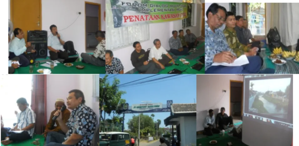
Figure 6. Discussion with the community at Keparakan Source: Soemardiono, B, 2012
Through discussion with communities, it was identified that there is some potential as well as problems in the urban area of Code River from the economic, societal and ecological aspects. Although a community forum regarding maintaining the ecological aspects already exists, they did not pay attention to the aesthetics of Code River and unplanned land use along the river. The urban areas are lacking green elements, although along some parts of the riverbanks, they have improved its quality through simple greenery, however the decreased function of the riverbanks has occurred due to insufficient open space. Discussion with different community stakeholders is very effective in overcoming some problems due to the improvement of social-economic as well as ecological aspects that result. For instance, the community in the dense settlement of Gemawang have not used the natural beauty of the landscape and the availability of unbuilt areas as a capital yet.
In addition, the community in Tegalpanggung is very open and ready to move toward revitalization and in Keparakan they wanted better accessibility to their potential home industry and discussed their inability to provide facilities promoting their shoe collections and parking areas for guests because of insufficient self-financing. In addition the night cuisine in Wirogunan which is managed by the community is very unique using the river’s atmosphere as the main attraction. Furthermore the discussion concluded that such a holistic and integrated development should be made along the urban riverbanks.
4.3 Concept for a new development of Code River
This section reports the recorded data, which includes problems and opportunities in the urban river bank area. By considering structural linkage along with intensive discussion with the local community, the concept is developed.
4.3.1 Identification, criteria and concepts of Gemawang Identification:
a) Gemawang is one of the high density settlements, located very close to the famous monument of Yogyakarta and Tugu. A social gap occurs in this area between the new inhabitants and the indigenous who are very poor.
b) The natural beauty of the landscape and the availability of unbuilt areas and ponds have not yet been optimally used.
c) The community forum called “Pamerti Code” was established to maintain sustainability of the river, for instance to keep it clean and without any litter.
d) Around the river bank in the district Gemawang, there are several recreation facilities such as a Culture House, pedestrian way along the river, and gazebos. Those provide opportunities for water recreation.
In addition, the new Sardjito Bridge is attractive.
e) School and university students are expected as users of the recreational area along the river banks.
Figure 7. Existing condition of Gemawang.
Source: Soemardiono, B., 2012
Criteria:
a) Dense settlement in Gemawang should be redesigned and supported by open spaces.
b) Visible and easy access to the location has to be created, supporting facilities and public infrastructures for a new tourism destination also need to be developed.
c) The riverbanks, open spaces and the unused existing facilities must be revitalized.
Concept:
a) Redesigning new settlement with open spaces. Developing a new tourism destination in the form of water recreation with easy access to the location (main and side entrance) and keeping the beauty of the river as a natural landscape asset and planning sufficient public infrastructures such as toilets, parking areas and a mosque.
b) Revitalizing river banks and redeveloping existing facilities such as the Culture House Gemawang and gazebos.
Figure 8. Concept of Gemawang Source: Soemardiono, B. and A.F.Gusma, 2012
Figure 9. Redesign of new settlement with open spaces.
Source: Soemardiono, B. and Gusma A.F., 2012
4.3.2 Identification, criteria and concepts of Keparakan Identification:
a) Keparakan has middle density population (11.211 people in 54.75ha).
The area is close to the river and consists of five neighbourhoods (RW 7 to RW10, and RW 13). In 2011, the GDP of the local people was lower than that of the city of Yogyakarta. The economic condition can be categorized as poor (9%), middle wealth (79%) and wealthy (13%).
The unequal land capacity with rapid growth results in quite complex environmental gradation.
b) On the other hand North Keparakan is growing into the Kampong of shoemakers. It is managed by a cooperation, which has a membership of 50 families. Resulting from community discussion it was found they have had difficulties in creating the shoemaker village.
c) Community discussion reported that they are not able to provide showrooms for promoting their collections or parking areas for guests because of insufficient self-financing.
d) The people expect more transportation access and pathways along the river to access the shoemaker area.
Figure 10. Existing Condition of Keparakan Source: Soemardiono, B (2012)
Criteria:
a) Public housing facilities should be developed in order to avoid dense settlement.
b) Showrooms for promoting collections and other facilities should be included in the capacity of the buildings for management and development to be established.
c) Development of accessibility along the river and through the shoemaker village.
Concepts:
a) Development of city blocks and public spaces.
b) Designing display/showroom in a suitable location to promote the shoe-collections and to accommodate management.
c) Parking area as well as a pedestrian way through the village, river walkway and biking lane which reach the Keparakan shoemaker village.
Figure 11. Concept and linkage of Keparakan Source: Soemardiono, B. and Gusma A.F., 2012
Figure 12. Concepts of Keparakan: Development of showroom, city block and public spaces as well as river walk and mass transportation
4.3.3 Source: Soemardiono, B. and Gusma A.F., 2012Identification, criteria and concepts of Wirogunan
Identification:
a) Wirogunan is the closest settlement near the river which consists of eight neighbourhoods. The majority of people are middle-low income earners with low level education and practise.
b) The location is next to a recreational spot and a university, making Wirogunan popular for its cuisine. It has huge potential as a creative economy such as the Community Activity Unit (or Unit Kegiatan Masyarakat / UKM).
c) The night-cuisine tourism is very popular and spreads 300m along the river. The other potential products are “bird nests”, accessories, clothing and bags.
Figure 13. Existing condition of Wirogunan and the culinary tourism at night.
Source: Soemardiono, B.,2012
Criteria:
a) A linked facility should be developed in promoting the night cuisine market and other activities using the atmosphere of the natural river as an attraction.
b) Facilities for culinary activities should be promoted and developed as well as managed by the people.
Concepts:
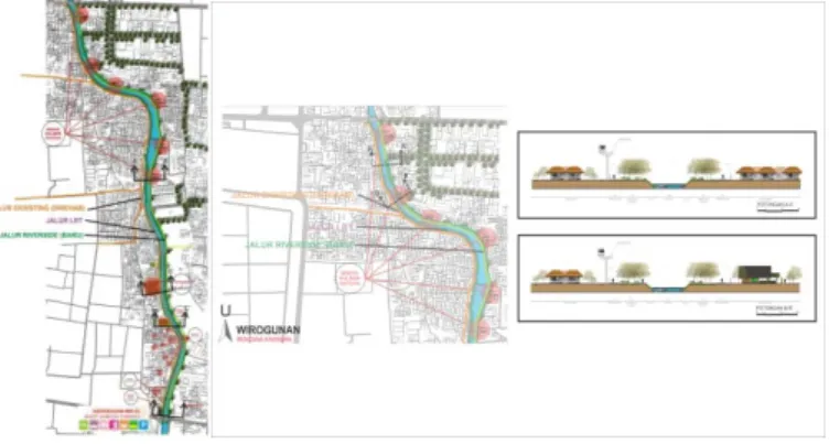
a) Design the linked culinary spots along the river (about 2800m) to promote the night culinary activities using the open public space and other activities which use the river as an attraction.
b) Design a parking area in each culinary spot with easy accessibility (river walkway).
Figure 14. Design the linked culinary spots along the river Source: Soemardiono, B. and Gusma A.F., 2012
4.3.4 Identification, criteria and concepts of Tegalpanggung Identification:
a) Tegalpanggung is a 35ha dense settlement close to Malioboro with a population of 9.217 (most of them are traders in Malioboro) and serves as the smallest neighbourhood (Rukun Warga/RW) with the highest density in Yogyakarta, followed by the unequal development between the west and east side. The poor community increases from year to year and in 2009 it reached 50% (in RW1, 2 and 3). There are lots of home industries in Ledok Tukangan whose products are sold in Malioboro and there is also an important community tourism organisation.
b) The community, according to the discussion, preferred privately owned housing and questioned whether any construction will be implemented on their dwellings.
Figure 15. Existing condition of Tegalpanggung Source: Soemardiono, B.,2012
Criteria:
a) It should strengthen the community organization by supporting the existing community.
b) Planning and redesign of settlement should be done in serving and supporting Malioboro.
Concepts:
a) Strengthening the existing community tourism organization.
b) Redesign privately owned city blocks equipped with other facilities such as showrooms (kampong gallery) and culinary spots to encourage development of tourism in well-known Malioboro.
Figure 16. Structural space and the Development of private owned city blocks and other supporting facilities of Tegalpanggung
Source: Soemardiono, B. and Gusma A.F., 2012
Figure 17. Redesign of privately owned city blocks of Tegalpanggung Source: Soemardiono, B. and Gusma A.F., 2012
5. CONCLUSION
This paper describes the concept of enhancing the riverbank quality as a natural landscape asset of the city Yogyakarta. The riverbank could not perform good functions as a natural landscape because of low aesthetic and ecological quality, for instance in Gemawang and Tegal Panggung district.
The concept proposed in this research shows that the riverbank in those areas will be improved by maintaining the high aesthetic quality of the landscape and by considering the ecological potential of Code River. Aside from its ecological potential, Code River has a unique character, which is known as
“to be seen from above”. That character, as well as the economic and social
value, is integrated with its ecological one to be set as a new paradigm of tourism.
Previous research on the urban landscape development concept have not been concerned with sustainability, which incorporates three aspects, namely ecological, economic, and social. In the concept resulting from this research, to optimize the potential of the river (Gemawang, Tegalpanggung), the unique characters of Code River were explored and determined as potential landscape assetsthat can be improved by renaturisation of the river. Those ecological aspects mentioned before will be incorporated within river tourism, which in turn, can improve the economies ofthose districts. Such ecological and river-tourism strategies will reflect the sustainable urban landscape concept. This concept was formulated based on discussion with the neighbourhood community in four selected districts as research cases, with the resultant criteria.
Holistic planning and consideration in land use should be done under participation of the stakeholders such as in the form of Local River-based Community, namely Pamerti Code. The outcomes of the participation should be considered as potential factors in creating new concepts.
The concepts regarding land use as a result of this research are: 1.
developing mixed use vertical housing in the river banks and housing in Central Business District (Tegal Panggung). 2. Land sharing is also proposed as a land use concept for sustainable Urban Space Consolidation, such as developing special housing for people, which is safe from flooding.
If the concept is implemented, the riverbanks become an open space which can maintain the ecological functions and qualities of biotic and non-biotic components. Green Kampung as vertical housing settlements should be integrated with multiple transport modes (automobile and biking) infrastructure to keep the city tourism within the existing and cheap infrastructure for future development. Considering landscape values and land capacity can strengthen the quality of urban areas. Those two aspects should be considered in the development program. Focusing on the urban area of Code River and considering public participation potential for tourism can be developed and unplanned land use avoided.
ACKNOWLEDGEMENT
The authors are grateful to the reviewers for the comments on the original manuscript and also the Department of Public Works, Housing and Mineral Energy Resources Yogyakarta, Indonesia. I would like to thank Achmad Suradji, Sri Nastiti, R.Winton Danardi and Tanti Satriana Nasution whose comments and ideas helped to improve this paper.
REFERENCES
Andersson, E. (2006). “Urban Landscapes and Sustainable cities”, Ecology and Society 11(1):
34, Stockholm.
Bergstrom, S.T,T.Elmqvist, P.Angelstem, and C.Alfsen-Norodom, (2006). “Scale mismatches in management of urban landscapes”. Ecology and Society 11(2): 16, Stockholm.
Breen, A. and Dick, R. (1994). Waterfront, Cities Reclaim Their Edge, McGraw-Hill Inc, New York, 1-10.
Direktorat Bina Tata Perkotaan dan Perdesaan, Ditjen Cipta Karya, Dep. PU, (1998).
Pedoman Penataan Ruang Kawasan Perkotaan Tepi Air di Indonesia. Jakarta.
Lynch, K. (1979). The Image of the City, The MIT Press, Cambridge, Massachussets and London, England.
Muerb, R. (1995). Stadtoekologie in der Planungspraxis.
Maryono, A. (2005). Ecological Hydraulics of River Development (2nd Edition), Postgraduate Study UGM.Yogyakarta.
Nicholin, P. and Repishti (2003). Dictionary of Today’s Landscape Designers. Skira, Italy.
Peraturan Pemerintah Republik Indonesia No 38 Tahun 2011 Tentang Sungai.
Simonds, J.O.and Starke, B.W. (2006). Landscape Architecture, 4th Edition.
Susilo, A, H. (2006). Evaluasi Lansekap Perkotaan u merevitalisasi RTH dalam mewujudkan Konsep Green City, UPN, Surabaya.
Triquell, A.L., (Eds.) (2012). Urban Landscape, Loft Publication.
Turner, T. (2009) URL: http://www.gardenvisit.com/blog/2009/03/20/definition-of-a- sustainable-urban-landscape/
Zahnd, M. (2006). Perancangan Kota secara Terpadu. Kanisius, Yogyakarta