Suburban Expansion and Social Characteristics
of Migrant Families in Beijing since the 1990s
著者
GU Jiang
journal or
publication title
The science reports of the Tohoku University.
7th series, Geography
volume
61
number
1
page range
63-81
year
2015-08
URL
http://hdl.handle.net/10097/60655
Suburban Expansion and Social Characteristics of Migrant Families
in Beijing since the 1990s
Jiang GU*
Abstract Since comprehensive reform and the opening up of the Chinese economy in
the first half of the 1990s, the unit yard system that had characterized the spatial struc-ture of Chinese cities since the 1950s began disintegrate. Welfare housing was replaced by commercial housing. A large number of migrant families moved to big cit-ies such as Beijing and Shanghai. In this paper, we first examine the housing develop-ment process in Beijing. The results of a remote sensing analysis revealed that urban expansion in Beijing during the period from 1988 to 2005 was mainly due to housing development in suburban areas. Due to redevelopment in the core area and the intro-duction of large-scale suburban development, migrants’ living patterns have changed
remarkably in recent years. As a result, our second objective was to conduct a ques-tionnaire survey with 500 respondents to examine the social characteristics of migrants. We found most respondents were from low-income migrant households who had moved
to the area within the previous five years. As it was difficult for them to rent a full housing unit, most chose room sharing instead. However, compared with the migrants in 1990s, newer migrants have higher education and technical training. They tend to hold stable jobs, and some of them have strong aspirations to purchase commercial housing in suburban Beijing.
Key words : Beijing, housing development, migrant, remote sensing
*Doctoral Candidate, Department of Earth Science Department, Graduate School of Science, Tohoku Uni-versity, 6-3, Aramaki Aza-Aoba, Aoba-ku, Sendai 980-8790, Japan
E-mail : [email protected] 1. Introduction
Since the start of the “Change, Reform, Open-up” policy in 1978, China has experienced
remarkable economic growth. In the last three decades, per-capita GDP grew from 381 CNY
in 1978 to 23,128 CNY in 2008. In 1991, Chinese leaders began introducing a market economy on the mainland, and since then, annual growth rate of China’s GDP has been over 8%. Such rapid economic growth has brought about drastic expansion and transformation of cities. Under the Open-up policy, and with the market economy deepening, land rental for large-scale
development and urban development has become more intensive. With the gradual expansion of the policy, more and more real estate developers have appeared in China.
The rapid pace of urbanization has meant that urban land expansion and land use/land cover change has been a key subject for studies on dynamic changes of urban land use (Dewan and
Yamaguchi, 2009). This paper examines the following two issues. The first is the process of spatial expansion of the Beijing suburban residential area ; we focus especially on the land use changes in the area between the 4th and 6th ring roads. The second is the social-economic
characteristics of migrants living in the suburban areas. The study area between 4th ring road and 6th ring road was selected because that area has been the most vigorously developed for residential purposes in the past two decades.
With an in-depth understanding of the residential development in this area, we will study
the processes and patterns of the rapid spatial expansion in Beijing. Furthermore, we will investigate the socioeconomic characteristics of the migrants living in the Beijing suburban area. A questionnaire survey will be conducted to clarify the detailed characteristics regarding the current situation of migrants.
2. The Population growth of Beijing city since the 1980s
In China, a population control system called the “the household registration system” was in place before the Open-up policy. This system was intended to ensure local residents the
right to employment, education and social welfare, and to limit population migration. As the system was strictly enforced, people were not able to change their registration information.
After the Open-up reform, however, a large number of people left their hometowns to look
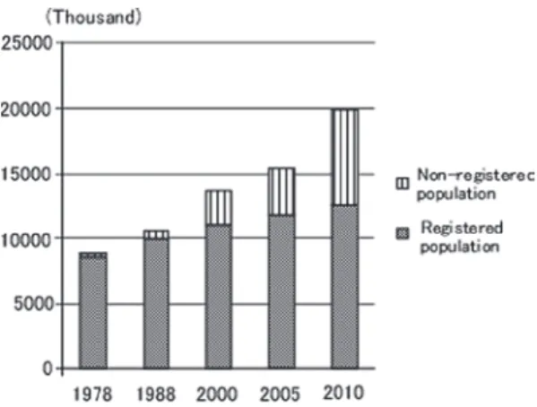
for better work opportunities in cities, especially in mega cities. This group of people gave up stable jobs and situations in their hometowns and became migrants. The urban population of Beijing has experienced remarkable growth over the past 32 years ; the population was 8,715,000 in 1978, 13,636,000 in 2000, and 19,979,000 in 2010. A large part of the population increase in Beijing had to do with the increase in migrants (Figure 1). Although migrants in Beijing numbered only 218,000 in 1988, that total rose to 7,407,000 in 2010.
Figure 1 Population growth in Beijing (1978-2010). Source : Beijing Statistical Yearbook (2011)
Since the change in the housing distribution system in 1998, the work unit has stopped offering welfare housing. In Chinese cities, the basic administrative unit is called the street unit. The street unit is a bridge connecting citizens and the government. It is also based on Chinese-style democracy. In Chinese cities, grassroots democratic elections of communist
party members are done at the street-unit level ; each street unit is equipped with a party
branch. However, after the reform and opening-up, the built-up area of Beijing experienced a
rapid expansion. Through this rapid expansion, the functions of the street unit, such control-ling residents, has collapsed due to the increase of migrants.
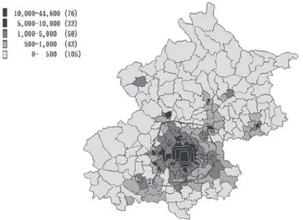
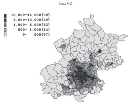
Figures 2 and 3 show the population density based on the street-unit system in 2000 and
2010. Each block in these figures represents a street unit, which is also a census tract. We collected the data from the fifth and sixth Chinese population censuses in 2000 and 2010. Since the year 2000, China’s population census has been taken every ten years. Information was collected from both migrants and local residents in the census. The figures show clearly that the densely built-up area experienced a rapid expansion between the fourth and sixth ring
roads during the period 2000-2010.
Figure 2 Population density of Beijing city by street-unit in 2000 Source : The fifth Chinese population census
3. Methodology and Data Sources
3.1 Examination of Beijing urban expansion since the 1980s : spatial analysis by remote sensing
Landsat imagery provides up-to-date land use and land cover information on a small scale
and at a reasonable cost with good accuracy (Sharma, 1984). To create the land use map of Beijing, we used Beijing Tm imagines from different time periods ; to understand the process of how the suburban area of Beijing developed, a time-sectional comparison was completed.
Simultaneously, the areal differences of Beijing at the same times were analyzed.
A supervised classification was used in this analysis. The appropriateness of the catego-ries was examined by sample verification. We chose several sites for each category, and con-firmed the consistency between results of the classification and the reality.
We made land use and land cover (LULC) maps using Landsat satellite images of Beijing. These maps allowed us to examine urban LULC changes. All the LULC were classified into 6 land use categories : (1) densely built-up area ; (2) agricultural land ; (3) green space ; (4)
for-est ; (5) undeveloped areas ; and (6) water.
The LULC changes were analysed using satellite images from 4 time series, for 1988, 1995, 2000 and 2005, collected by the Institute of Remote Sensing Applications, Chinese Acad-emy of Science. Mapping data of Beijing city (1985-2005) were presented using IDRISI Taiga
and ArcGIS 10.0 software.
Figure 3 Population density of Beijing city by street-unit in 2010 Source : The sixth Chinese population census
3.2 Examination of social and economic characteristics of migrants in Beijing : Questionnaire survey
In Beijing’s urban expansion, migrants were the main driving force of population growth, especially in the rapid growth after the 1990s. More urban land space was needed to meet the flood of migrants. Under the control of the unit yard system, the unit security was the founda-tion of the social welfare for people. As a result, people could not move because only the work unit could offer them a job. With the effects of the globalization and the disintegration of the work unit system, people in cities and rural areas began to move in the 1990s. Beijing attracted a lot of people from all over the country ; as the capital of China, people saw it as offering opportunities for good jobs and services.
In order to obtain data on the socio-economic characteristics of migrants, we conducted a
questionnaire survey in the area between the fourth and sixth ring roads. Migrants living in the study area were scattered, and it was difficult to find concentrated areas of them. There-fore, we decided to work from two high schools located in the following areas : ChangPing in the northern suburbs, and Yizhuang in the southeastern suburbs.
In general, due to the household registration system, it is difficult for migrants’ children to attend local schools. The selected schools, however, were opened specifically for the children of migrant families. With the permission of the school administrative offices, we asked parents to complete the questionnaires. The survey was conducted from March 8-24, 2012.
Ques-tionnaire items included : (1) Basic information of householder (age, income, occupation) ; (2) family size ; (3) housing type and ownership ; (4) the main reason for moving to the present residence ; (5) features of work commute.
We were able to obtain responses from 500 total migrant households, 278 in the ChangPing area and 222 in the Yizhuang area. Respondents were 54.8% male and 45.2% female.
4. Land use and land cover changes in Beijing using Landsat images 4.1 Land use and land cover changes of Beijing (1988-2005)
Figure 4 shows the LULC pattern in 1988. Large areas of agriculture land (yellow) can be seen, especially outside the fourth ring road. Agricultural land constituted the largest land area, occupying about 48% of the total area (Figure 5). The next largest area of land use by type was densely built-up area (red), occupying around 31% of the total area. We can confirm
that most of the area inside the fourth ring road was already built-up in 1988. The
undevel-oped area (dark blue) can be seen in the northern, southern and eastern suburbs, occupying about 12% of the total land area. At the same time, there were very few green spaces (light green) and forests (dark green).
In 1988, the basic boundary of the built- up area of Beijing was the fourth ring road.
Although we can see several densely built-up areas outside of the 4th ring road, some of these
extended from 4th ring road. This area was developed earlier than other suburbs due to a good environment and peoples’ preference. Moreover, from 1949 to 1980s, the main develop-ment projects were located in the central area of Beijing. They included construction of big buildings, such as the National Library of China, the Beijing International Hotel, and other mag-nificent structures among Beijing’s top ten buildings in the 1980s.
Figure 6 shows the LULC map for Beijing City in 1995. Compared with one in 1988, a large scale decrease in agricultural and undeveloped land can been seen (Figure 5). About
Figure 4 Land Use and Land Cover (LULC) map of Beijing City, 1988
Figure 6 Land use and land cover in Beijing, 1995
Figure 7 Land use and land cover in Beijing, 2000
23% of such land was developed (Figure 6). These lands were transformed to either built-up
areas, or green space. As a result, the share of agricultural land in the total area decreased to 29% while that of densely built-up area increased to 51%. However, a large portion of the land
between the 4th and 6th ring roads was still agricultural in 1995. By 1995, a large portion of the agricultural land in the southern area within the 4th ring road had disappeared.
The 1990 Asia Olympic Games were held in Beijing. The stadium and park used in the Olympics were constructed along the North 4th ring road and in west Beijing. Since 1993, as mentioned earlier, a market economy has been introduced into Mainland China. As a result, the government has allowed the land to be rented for development. Commercial residential buildings were built on a large scale near the Beijing Olympic Park. These were the first group of commercial housing projects that were sold or rented to foreigners.
At the same time, a redevelopment project of the inner area was begun in the 1990s. The old commercial centres, such as Wangfujing Street and the Qianmen Area, were reconstructed by the local Beijing government. This development project in the 1990s was based on a detailed urban development plan including zoning. Before this, there had been no zoning system introduced in Beijing.
Figure 7 shows the LULC map for Beijing City in 2000. Compared to the LULC map of 1995, we can confirm that the share of densely built-up areas and green space continued to
increase, while the share of agricultural land continued to decrease (Figure 5). The percentages of main land use types for the total area were as follows : densely built-up area,
58%, agricultural land, 19%, forest 1%, green space, 9%, underdeveloped area, 9%.
In the year 1988, we could see there were several satellite towns located in the suburb area, but they were isolated. In 1995, they had begun to connect with the main densely built
-up area. By 2000, it was clear they were closely connected with the main densely built-up
area, and all of them were included in the Beijing metropolitan area.
Beginning in 1998, the housing distribution system was changed, as mentioned earlier, and the number of developers increased substantially. They tried to construct new types of resi-dential housing in suburban Beijing on a large scale. On the other hand, new highways such as the Badaling and JingTong highways, provided significant improvements to the Beijing road sys-tem. Residents who lived in the suburban residential areas and owned a private car could eas-ily travel to the downtown area of Beijing city.
On the other hand, the Zhongguancun high-tech industry base was constructed in 1999, in
the northwest area of Beijing city. The local government also tried to start large construction projects in other parts of China, for example, the construction of Beijing Economic-
Technologi-cal Development Area, located in the southeast of Beijing city.
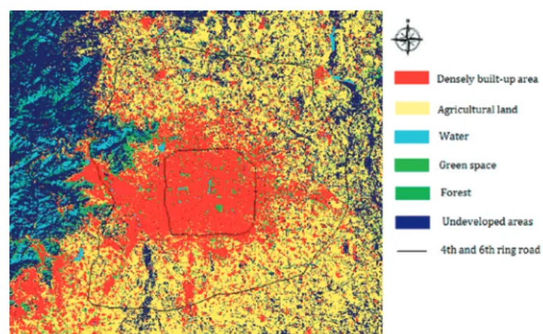
Figure 8 shows the LULC map of Beijing City in 2005. Compared with the 2000 LULC map, it may be seen that a large amount of agricultural land has been replaced by densely built
-up areas and green space (Figure 5). As a result, the share of agricultural land decreased to 8% in 2005, while that of densely built-up area increased to 67%. Due to the construction of
new residential areas in suburban Beijing, a lot of green space appeared. Real estate develop-ers paid more and more attention to creating a good environment, including green space, in order to attract residents ; as a result, green space increased remarkably.
Due to the successful application of Beijing for the 2008 Olympic Games, the speed of infrastructure construction increased tremendously in the 2000s. New highways and subways were constructed. For example, the No. 13 subway, located in the northern suburban area of Beijing, was constructed in the early 2000s.
On the other hand, the Beijing local government proposed a new stage of regeneration or redevelopment projects, such as the construction of a new central business district (CBD). As a result, a large number of unit yards had to move out of the Beijing core area and build new fac-tories in suburban areas. In the 2000s, it was necessary to collect the land for this kind of large reconstruction process. The Beijing local government tried to construct large-scale
res-idential areas, for example the TianTongYuan in the Chanpin District of the northern suburbs, in order to replace the housing of residents who used to live in the core area.
4.2 The pattern of spatial expansion of built-up area in Beijing since the 1980s
If the LULC classification of the satellite images for the 4 periods is completed, it is possi-ble to show changes in land use patterns and to calculate the change in area for each type by overlapping the maps (see Figures 9 and 10). In this study, ArcGIS 10.0 software was used to process data of satellite images.
In Figure 9, the purple indicates the newly expanded densely built-up area during 1988
-1995. In this period, the majority of the smaller areas of expansion were dispersed beyond the 4th ring road. At the same time, continuous expansion of built-up areas were seen along trunk
roads, which connected the core area and satellite towns, especially in the northwest and south-west regions. There were the national highways, such as the BaDaLing highway. On the other hand, as the southeastern suburb was relatively low in altitude and its land condition was not good, local people did not prefer to live there. In Figure 10, the green areas represent the newly expanded, densely built-up areas during 1995-2000. In this period, due to extension of
built-up areas in the suburbs, the satellite towns were connected to the core metropolitan
region.
The orange areas in Figure 11 show the extension of land for densely built-up areas from
2000-2005. During this period, expansion was tremendous in all directions. The densely
built-up area rapidly increased until it occupied almost all of the formerly agricultural land. As
a result, the composition of land use by land use type inside the sixth ring road became as follows : built-up area 67%, green space 14%, and agriculture land 8% (Figure 5). The built
Figure 9 Urban spatial expansion in Beijing (1988-1995)
Figure 10 Urban spatial expansion in Beijing (1995-2000)
5. Social characteristics of migrants in suburban Beijing
In the last section, we considered the remarkable expansion of the urbanized area of Bei-jing over the last three decades. However, we wondered what kinds of people are living in the newly developed areas? What are their living conditions? We address these questions in this section.
5.1 Results of previous studies on characteristics of migrants
China’s official population statistics have been based on the household registration system and carried out by the street units (neighbourhood committees) since the establishment of Peo-ples’ Republic of China. These statistical surveys mainly dealt with local people whose resi-dent registration was permitted in Beijing. Migrants were generally excluded from the sur-veys. As a result, there is very little information on the living conditions and socioeconomic characteristics of migrants in the public data. However, there are studies on migrants based on fieldwork in Beijing. From these studies it is possible to glean the fundamental characteris-tics of migrants during the 1980s and 1990s. This literature review was based on the CNKI and Science direct database.
5.1.1 The early migrants : 1983-1999
Ji (1985) surveyed the educational background and jobs of migrants living in the core area of Beijing with a questionnaire survey in 1982. He considered the migrants that moved to Beijing over the period from 1976-1982. Results showed that 60% of respondents had less
than a junior high school level of education. Of these migrants, 50% were manual workers and 10% were unemployed. There were few white-collar employed workers. Thus, the portrait
of migrants presented by Ji corresponded to the general impression about migrants.
According to Liu and Gu (1999), who studied Beijing urban villages, migrants from the same hometown tended to live in the same village in the Beijing metropolitan area. Many sub-urban villages adjacent to built-up areas of Beijing were transformed to urban villages by the
influx of migrants. Most migrants came to Beijing alone. Living conditions varied widely from village to village, and were also very different depending on the local residential area. Some urban villages attracted a large number of poor people who had lived in rural provinces. Most migrants in these urban villages lived in temporary housing with poor sanitary and secu-rity conditions. Moreover, migrant workers engaged in the primary and secondary industries, with most simple, unstable, temporary, unskilled and low-income jobs.
5.1.2 Emergence of family migration : 2000-2008
In China, migrants and local residents obtained housing in completely different ways. Local residents could obtain housing through their enterprises, or could purchase commercial and low-cost public housing. In the case of migrants, however, the only option was to live in
rented housing in a suburban area or in the housing provided by enterprises (Wu, 2002, 2004). In addition, compared to single migrants, migrant workers with families hoped to start in a sta-ble occupation. Forty percent of migrant families undertook a ‘Whole family migration’, which means the older and younger generation family members moved to Beijing once the household head found a stable job (Hou, 2007).
5.1.3 Emergence of the New Migrants (2009-present)
A group of new migrants has arrived since 2009. Chen and Zhang (2012) examined the distribution of living space of the low-income population in Beijing. They classified residents
into three groups : local people, floating-type migrants and new-type migrants. New-type
migrants were younger and had relatively higher educational backgrounds and skills compared to floating-type.
The new-type migrants’ living conditions, however, were still not good. They were not
expecting to obtain the life condition of local residents, and accepted the arduous living condi-tions easily. However, it was clear that the migrants made an effort to be accepted by the local community, and that having a sense of community had the greatest impact on their satisfaction with their living conditions. On the other hand, a separate kitchen and bathroom was most important in the migrants’ evaluation of housing conditions (Li, 2011).
5.2 Study area of questionnaire survey
Since the housing supply system changed in 1998, as mentioned earlier, work units have stopped offering welfare housing. To replace work units, the supply of commercial housing has increased rapidly. However, in Beijing, housing demand had continuously exceeded supply due to remarkable population growth. As a result, housing prices also increased substantially. Moreover, migrants had to dwell in cheap housing with high rent in suburban areas due to hous-ing price increases.
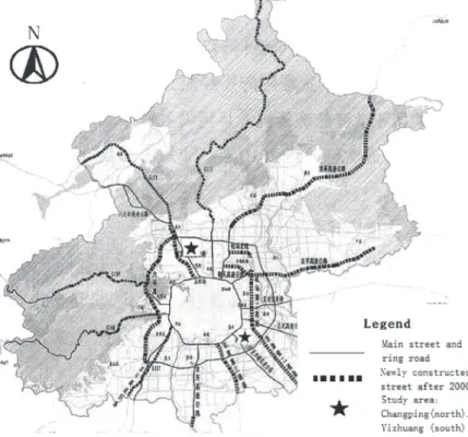
The Beijing metropolitan area covers an area of more than 750 square kilometres, and has a total population of more than 20.6 million (2012). We chose two satellite towns as our study areas located between the fourth and sixth ring roads. The first is ChangPing town located along the Badalin motorway that connects Beijing to the Great Wall in the northern suburb ; the other is YiZhuang, situated along the highway connecting Beijing to Tianji in the southeast-ern suburb. Both study areas have experienced rapid development since the comprehensive reform and opening up (Figure 12).
In Changping, most of the local residents used to be farmers. In 1998, the construction of the Badaling Highway toward the Great Wall from Beijing was finished, allowing citizens from downtown Beijing to easily visit the Great Wall and Ming Tombs in the ChangPing area. The development of tourism and the convenient transportation situation were the main reasons for the development of this township.
located in the YiZhuang area, a southeastern suburb of Beijing. The BDA is one of the National Economic and Technological Development Zones supported by the Chinese central government. Since 1992, the YiZhuang area has attracted a lot of foreign and domestic invest-ment, and has become one of the high-tech industry and advanced manufacturing bases of the
Beijing-Tianjin development corridor.
5.3 Characteristics of migrant families in suburban Beijing 5.3.1 Income level, ownership of housing and occupation
The Yizhuang area had a higher percentage of high-income households than the Changping
area (Tables 1 and 2). The percentage of respondents with incomes exceeding 20,000 CNY was 7% in Yizhuang and 3.6% in Changping. The percentage of low-income families was also
relatively smaller in Yizhuang than in ChangPing. Since there are many large factories that provide formal jobs in Yishuang, a large part of the migrant population there seems to have obtained formal jobs. According to the survey, 37% of respondents in Yishuang worked in fac-tories (Figure 13). In ChangPing, although the percentage of office workers was relatively high (35%), the proportion of small private businesses, recognized as an informal sector, was
Figure 12 Expansion map of Beijing city and the study area.
also large.
In addition, a large percentage of household heads were reported to engage in informal jobs. In ChangPing, 16% of the population was unemployed, much higher than in Yizhuang (7%). In both Yizhuang and ChangPing, average reported income of respondents was 4,908 CNY and 6,520 CNY, respectively, which was lower compared to the average income of the Bei-jing population.
Furthermore, in both study areas, the education background of the household head was generally not very high. About 39% of total respondents, however, had a final diploma higher than high school. This group reported that it was easy for them to obtain stable and high
-income jobs because of their high academic background. Many creative industrial companies have located in the new satellite towns of Beijing such as Yizhuang. They offer good job opportunities. However, the people who come from the countryside tend to migrate to Beijing without any promise of employment. Even if they have a relatively high educational background and skills, most of them tend to engage in low-income jobs at first. Most of those
in the new industrial area are engaged in low-income jobs.
Table 1 Income levels in the two study areas
Income level Household in Changping Percentage : % Household in Yizhuang Percentage : %
¥0-1,500 42 15.1 28 12.6 ¥1,500-5,000 165 59.4 71 32 ¥5,000-20,000 53 19 88 39.6 More than ¥20,000 18 6.5 35 15.8 Total 278 100 222 100 ¥1=US$0.16
Source : Questionnaire survey.
5.3.2 Size of household
Survey results indicated that 63% of respondents had more than two children. Although China has implemented a very strict family-planning policy, migrants’ households, on average,
tend to have more children and more dependent family members. Once household heads find jobs in Beijing, they usually bring their children there. The education standards in Beijing are much higher than those in the towns from which the migrants come. In general, migrants have strong desire to provide their children with a good higher education. Educational back-ground is an important factor in social mobility. Therefore, many migrants want to settle in Beijing permanently, and to adapt to the local community. When the second generation grows up, they will not have a different accent that indicates their origins and sometimes makes them a target of social discrimination. Due to migrants’ hardworking ethic and high educational background, many second-generation migrant offspring obtain increasingly good jobs.
How-ever, more children mean more pressure. In China, although all local residents receive com-pulsory education (primary and junior high school), migrants do not. In general, they must pay higher tuition fees in order for their children to attend the local school.
5.3.3 Housing ownership
The basic housing style in China is apartment buildings. In both Yizhuang and Changping, the rents for apartments are much cheaper than in central Beijing. For the people coming to Beijing without good skills and education, suburban areas may be a good place to begin elevat-ing their livelihood and social status.
The price of housing in the suburban areas, however, is still still too high for most migrant families. In both Yizhuang and Changping, 75% of respondents lived in rental housing. Although there is a great deal of new housing construction in the Beijing suburbs, there is a shortage of apartment houses such as 1DK or LDK, which are affordable for migrants. Many migrants, therefore, have to live in cheap rental apartments, or share standard apartments with other migrants (Table 2).
In the 1990s, many poor migrants chose to live in the urban villages, most of which were
Table 2 Migrant housing ownership in suburban Beijing Income/Housing ownership ¥0 -1,500 ¥1,500 -5,000 ¥5,000
-20,000 More than ¥20,000 Total
Rent for housing 55 204 94 22 375 (75%)
Already purchased one house 11 24 26 19 80 (16%)
Purchased more than two houses 2 4 11 6 23 (4.6%)
Will purchase housing soon 2 4 10 6 22 (4.4%)
Total 70 (14%) 236 (47.2%) 141 (28.2%) 53 (10.6%) 500 (100%)
¥1=US$0.16
located close to the built-up areas. Currently, however, many migrants are opting to share
rooms with others and live in the Beijing suburbs. Room sharing is one common idea for migrants. In general, migrant room sharing is a way to reduce the rent per family. For exam-ple, 2LDK is the most popular room sharing in the Beijing suburbs. Each family has a private space (bedroom) and shares the living room, the kitchen and the bathroom.
Many respondents strongly aspired to purchase commercial housing in suburban Beijing. During the 1990s, ‘get money in city and consumption in the hometown’ was the main mind-set
of migrants. This has already changed. Present migrants have a very high desire to stay in Beijing. They work very hard, and have a clear goal—to bring their families to the Beijing so that they can enjoy city life. This is totally different from the old type of migrants in the 1990s (Hou, 2007).
5.3.4 Main reason for moving to present residence
Figure 14 shows the most important reason why respondents gave for moving to Beijing. About 72.2% of all respondents in the two study areas replied employment as the most impor-tant reason for their migration.
Following jobs, 18% of respondents replied the education of their children was the most important reason. This result supports the general understanding that migrants generally have a strong desire to give their children a higher education. In addition, 8% of respondents replied private business opportunity was their reason for moving, with businesses judged to be small self-employed businesses from the results of the occupational structure mentioned
ear-lier. On the other hand, it is noted that none of respondents pointed to a medical condition as a rationale. Medical services in Beijing are expensive and inconvenient for the migrant families. Due to the housing registration system, the migrants are not able to benefit from the local med-ical Insurance.
5.3.5 Work Commute
Table 3 shows the spatial separation between respondents’ workplaces and dwelling places. The distribution of respondents’ residences were as follows : the zone within 4th ring road, 28% ; the zone between 4th ring road and 6th ring road, 51% ; and the zone outside the 6th ring road, 21%. This result is consistent with the point mentioned earlier that many migrants presently live in suburbs. On the other hand, 66% of residents work in the zone between 4th ring road and 6th ring road ; 20% within the 4th ring road, and 14% outside of the 6th ring road. These results indicate that the zone between 4th and 6th ring roads was the main zone of housing and work for migrants. However, there are many migrants who com-mute beyond this zone ; for example, about 8% of respondents comcom-muted from inner side of the 4th ring road to the intermediate zone between 4th and 6th ring roads (Table 3). Moreo-ver, there were respondents who commuted from the inside zone of the 4th ring road to the outside of 6th ring road, although not many.
Table 4 presents the distance and duration of respondents’ commutes. Most used public transportation for commuting to work. However, it took a relatively long time, on average. More than half of respondents reported a commuting time of more than half an hour. Moreo-ver, 13% of respondents spent an hour or more on their commute. The public transportation system is considered to be very cheap and convenient.
On the other hand, due to their low-income level, very few of the migrants could afford to
purchase a private car. Only 41 respondents (8%) reported their main means of commuting was by bicycle, motorcycle or on foot.
6. Conclusion
Since comprehensive reform and the Opening-up started in the first half of the 1990s, a
remarkable level of urban development has taken place in Beijing. The population of Beijing
Table 3 Locations of workplaces and dwelling place
Location of workplace
Location of dwelling place of housing
Total Inside the 4th
ring road
Zone between 4th ringroad
and 6th ring road
Outside the 6th
ring road
Inside zone of 4th ring road 45 39 15 99 (20%)
Zone between 4th
ringroad
and 6th ring road 83 189 59 331 (66%)
Outside the 6th ring road 13 29 28 70 (14%)
Total 141 (28%) 257 (51%) 102 (20%) 500 (100%)
metropolitan area tripled from 1990 to 2010. In particular, suburban areas have developed tre-mendously. Based on the facts discussed in the preceding sections, we highlight the following findings related to the spatial expansion of the Beijing metropolitan area and the socioeconomic characteristics of migrants :
1) Beijing has experienced a rapid population growth since the Reform and Opening-up
policy. The urban population of Beijing had remarkable growth over the previous 32 years : 8,715,000 in 1978, 13,636,000 in 2000, and 19,979,000 in 2010. A large part of this population increase was due to the increase in migrants.
2) From 1988 to 2005, a remarkable decrease of agricultural land can be seen in the Bei-jing suburban area. In the area between the fourth and sixth ring roads, agricultural land decreased from 48% in 1988, to 8% in 2005.
3) Although the expansion of the built-up area was relatively limited in the north and
west areas of Beijing in the 1980s, it has occurred in all directions since the 1990s. Moreover, in the 1980s, the development plan of Beijing city focused on the construction of symbolic buildings. The necessary infrastructure was constructed to meet the daily needs of the public. After that, in the 1990s, the local government turned more toward large-scale development
projects in both inner and other areas of Beijing city. The new development zones and the high-tech industry base were constructed in the suburban area, surrounded by the new type of
commercial housing built by developers. After 2000, the speed of development and construc-tion significantly increased, and residential development of the Beijing suburban area was seen on a large scale.
4) Through this large-scale residential development in Beijing, the areas of green space
rapidly increased, from 3% in 1988 to 14% in 2005. Developers tried to include large areas of green space inside residential areas in order to attract consumers from locally and from other parts of China.
5) In the 1980s and 1990s, the migrant workers engaged in primary and secondary indus-tries, with most simple, unstable, temporary, unskilled and low-income jobs ; they lived in the
shanties, temporary buildings and Illegal buildings located in the urban villages. After the
Table 4 the commuting measure and commuting time Commuting measure Commuting time Total Within 15 min 15 min -30 min 30 min
-1 hour More than 1 hour
Public transportation 23 106 209 51 389 (77.8%)
Private car 1 21 36 12 70 (14%)
Bicycles, Motorcycles or on foot 6 26 7 2 41 (8.2%)
Total 30(6%) 153 (30.6%) 252 (50.4%) 65 (13%) 500 (100%)
2000s, new migrants had higher educational backgrounds, and were more competitive in terms of obtaining a stable job in a suburban area. They tried to rent commercial housing, instead of urban villages, and had a strong desire to purchase the housing in Beijing. However, survey results indicated that 63% of respondents have more than two children, and the income level of most migrants remains low. Compared with local residents, migrants are unable to benefit from social welfare, and bear more of the load of their children’s upbringing due to having more children. At the same time, the price of housing in Beijing rose dramatically. As a result, the migrants still have poor living conditions compared with the local residents, and a large number choose room sharing, together with using public transportation for their commute to work.
Acknowledgement
I would like to express my sincere thanks to Prof. Masateru HINO for his thoughtful advice and guidance.
References (*in Chinese)
Dewan, A. and Yamaguchi, Y. (2009) : Land use and land cover change in Greater Dhaka, Bangladesh :
Using remote sensing to promote sustainable urbanization. Applied Geography, 29 (3), 390-401.
Dewan, A. and Yamaguchi, Y. (2009) : Using remote sensing and GIS to detect and monitor land use and
land cover change in Dhaka Metropolitan of Bangladesh during 1960-2005. Environmental
Moni-toring and Assessment, 150 (1-4), 237-249.
Sharma, K.P., Jain, S.C. and Gacg, P.K. (1984) : Manual v/s Digital Land use classification from remotely sensed data—A case study in Roorkee-Dehradun region of Northern India. Proc. of Asian Conference
on Remote Sensing, Kathmandu, Nepal.
Chen, L., Zhang, W., Dang, Y. and Yu, J. (2012) : The spatial distribution, transition and residential
pat-tern of low-income residents in Beijing*. Geographical Research, 31(4), 720-732.
Hou, Y. and Hong, X. (2007) : The investigation report of Beijing migrants families in 2006*. Population and Development, 3, 102-110.
Ji, P. (1983) : The source, types and the age composition of immigrants in Beijing*. Population and Eco-nomics, 5, 43-49.
Ji, P., Zhang, K. and Liu, D. (1985) : A study of migrants’ education level and occupation in
Bei-jing*. Population Research, 1985(2), 25-30.
Li, Z. (2011) : A study of residential satisfaction in the neo-migrant enclaves of Chinese cities : a case of
Beijing, Shanghai and Guangzhou*. City Planning Review, 2011(12), 75-82.
Liu, B., Feng, C. and Shen, B. (2012) : Characteristics of intra-urban migration of rural migrant workers
in Beijing. Urban Studies, 19(5), 72-76.
Liu, H. and Gu, C. (1999) : The floating population concentration areas in Beijing : patterns, structure
and functions*. Geography Science, 19(6), 204-212.
Wu, S. (2010) : An analysis of the population classification model of the second generation of immigrants to
cities*. Journal of China Institute of Industrial Relations, 24(6), 74-79.
Yu, Z. (2007) : China’s floating population and their settlement intention in the cities : beyond the Hukou