トップページ - 横浜国立大学学術情報リポジトリ
30
0
0
全文
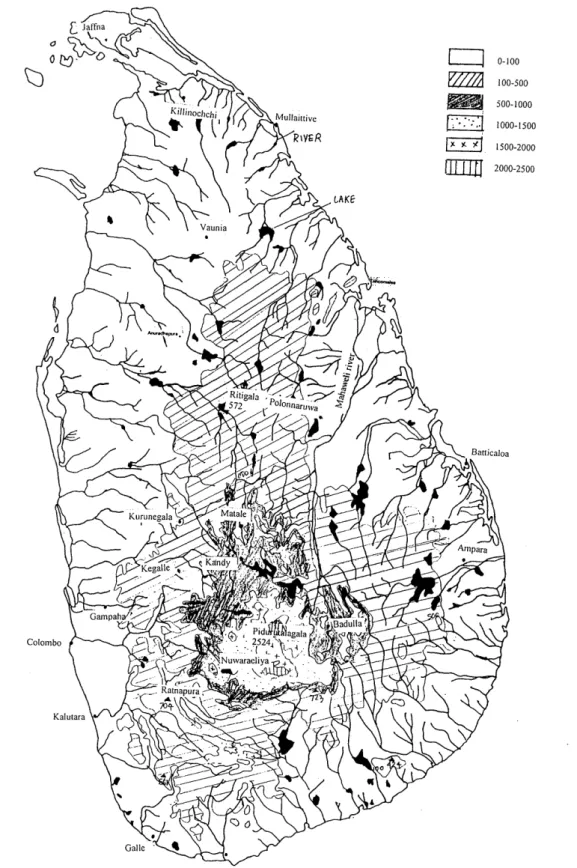
(2) Introduction Topography Sri Lanka is an island located in the Indian Ocean close to the south tip of India. The geographical coordinates are from 9" 50' to 5" 55' N latitude and 81" 53' to 79" 31' E longitude. The main island has a maximum length of 432 km in the north-south direction and 224 km in the east-west direction. The land area is 65,525 km2; together with the internal waters the total area is 67,095 km2 (Somasekaram, T. et al. ed. 1982) (Figure 1). The topography of Sri Lanka consists of a highland massif, situated in the south center, which is surrounded by an intermediate zone of upland ridges and valleys at a lower elevation. The intermediate zone is in turn surrounded by a n outer or lower zone of lowlands. A coastal fringe consisting of sandbar lagoons and islands skirts the main island. The mountainous area ranges from 500 m to 2500 m , with the highest peak of 2524 m a t Pidurutalagala. The land in the mountainous area accounts for a little less than one-third of the country's total land area. The remaining over two-thirds in the northern and northeastern part is flat and undulating, with gentle slopes (Somasekaram, T. et al. ed. 1982) (Figure 2).. Land Use About one-third of the land is put to agricultural use. Paddy rice is the dominant crop in terms of land use, but it is tea, grown under plantation agriculture, which earns the largest foreign exchange for the country. In the mid-nineteenth century under the British Colonial policies, tea was introduced to Sri Lanka a s a plantation crop. Vast amounts of tropical montane forest were cleared for tea plantations. In the dry and intermediate zones of the country, shifting cultivation was employed, which involves clearing the forest for a season or two of use, abandonment to fallow (which allows the forest to regenerate), and subsequent repetition of the cultivation cycle. Forest gardens are another dominant form of land use especially seen in the middle of the country. The forest gardens represent two or three-tiered structures consisting of shrubs in the understorey, medium-sized fruit trees in a mixed-level layer, and large fruit and timber producing trees in the canopy. Compared with typical agricultural fields, this increases the area for photosynthesis and thus production in vertical space. Structural characteristics of these gardens, including their high density and species diversity, are comparable to measures from natural forests in similar elevations and climates. Forests and wildlife use another third of the country's lands, and the rest is used for transportation, human settlements and various other uses.. Geology The land of Sri Lanka was never fully submerged by the sea. Hence only about 10% of the land area is covered by sedimentary rocks. Most of the country is underlain by crystalline rocks of Pre-Cambrian age. The rest is made up of Miocene limestone in the north and northwestern coastal regions and Quaternary deposits along the northwestern, southern and eastern coastal regions. Among the superficial deposits of recent origin in many parts of the country are alluvium on the river floodplains and loose unconsolidated sand in the coastal belt..
(3)
(4) Fig. 2 Topography of Sri Lanka (Source: National Atlas of Sri Lanka).
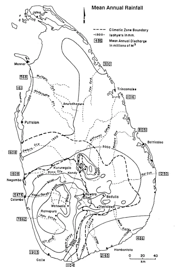
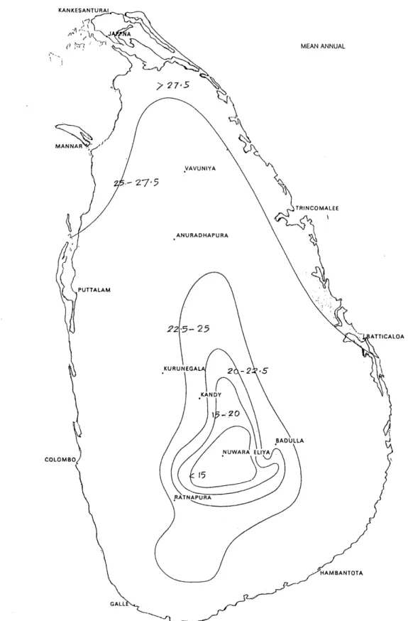
(5) Because of Sri Lanka's alternate seasonal exposure to heavy sunlight and high rainfall, rocks weather rapidly. The major factor influencing the soil formation in the country is the climate, followed by parent material and topography. Fourteen great soil groups have been recognized in Sri Lanka. Mainly these could be subdivided into two categories. Reddish brown earth and low humic gley soils are encountered in the dry zone and semi-dry intermediate zone, which has a n undulating terrain. In the wet zone and semi-wet intermediate zone with mountainous o r hilly and rolling terrain, the prominent soil type is red-yellow podzolic soil.. Climate and Rainfall Due to her location north of the equator, the climate of Sri Lanka is tropical monsoonal with a marked seasonal rhythm of rainfall. Two seasonal wind regimes determined by seasonal pressure and wind systems give rainfall and temperature variations. The annual rainfall comes in four distinguishable periods. The first, inter-monsoon period is experienced in March to April, which has constant daily weather with bright clear mornings and induced rain clouds followed by thunderstorms in the late afternoons. May to September is the southwest monsoon period, which brings the largest amount of rainfall to the southwestern lowlands. October to November is the second inter-monsoon period. Sometimes cyclones and occasional heavy rainfall, which produces floods or landslides, occurs in this period. The northeast monsoon period, which brings rain to the northern and eastern parts of the country, is experienced from December to February. Average annual rainfall is about 2000 mm (varying from year to year), but the distribution is not uniform over time o r geographical space. The country could be divided into two major zones according to climatic parameters. These are the wet zone 2500-5000 mm in the southwestern area and the dry zone in the northern part. The transition between these. two zones is identified a s the intermediate zone. The dry zone of the country has an annual mean rainfall of about 1250 mm (Somasekaram, T. et al. ed. 1982) (Figure 3). Sri Lanka's tropical location ensures uniformly high temperatures throughout the year, but the influence of the sea makes the island free from temperature extremes. Mean annual temperature in the lowland is around 27"C, with a mean daily range of about 6°C. Ground frosts can sometimes appear in Nuwara Eliya in the central highlands, where the mean annual temperature is 15°C (Somasekaram, T. et al. ed. 1982) (Figure 4). Relative humidity varies from 70% during the day to 90% a t night.. Hydrology Sri Lanka's only source of fresh water is rainfall. According to rainfall data, the country is richly endowed with high mean annual rainfall. It has 103 river basins, which cover 59,217 km2. The largest river basin is Mahaweli river basin. It has a length of 335 km and an area of 10,448 km2, which is one-sixth of the country's land area. In addition to the perennial river system, Sri Lanka has a well-established irrigation system built by the ancient rulers in the ancient capital in the dry zone. Large tanks were built to capture the monsoonal rains and utilize them in cultivation. The history of these goes back to 309 BC. The total number of such tanks in the country is about 18,000. The groundwater distribution is related to the geological formations and rainfall intensity. About 7% to 30% of rainfall goes to recharging the groundwater table in the dry zone. Groundwater is used a s a water source mostly in the dry zone..
(6) m Fig. 3 Rainfall pattern of Sri Lanka (Source: National Atlas of Sri Lanka).
(7) MEAN ANNUAL. Fig. 4 Temperature pattern of Sri Lanka (Source: National Atlas of Sri Lanka).
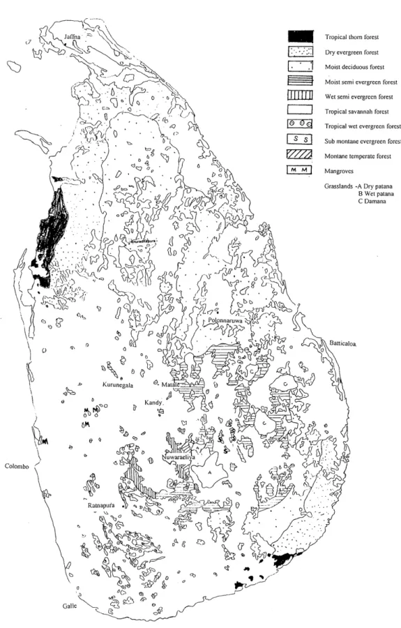
(8) Forests of Sri Lanka Until the 19th century Sri Lanka w a s almost entirely covered by natural forest. This situation changed drastically when the plantation crops were introduced and the land use patterns were changed, due to increase in population. In the 1880s more than 80% of Sri L a n k a ' s land w a s covered by natural forests. This w a s reduced t o 44% by 1956, after the plantation crops were introduced a t the beginning of 19th century. At present the total a r e a of forest in the country, including sparse forest, remains a t 2.375 million hectare (36.5% of total land area). The forest department i s the main authority to handle forest reserves (Somasekaram, T. et al. ed. 1982) (Figure 5). The Department of Wild Life Conservation and the Government Agents a r e the other authorities responsible for the forest in the country, according to the respective classifications. Forest reserves come under the jurisdiction of the Forest Department. National reserves and Sanctuaries, which include Strict Natural Reserves, National P a r k s , Nature Reserves, Jungle Corridors and Intermediate Zones, come under the jurisdiction of the Department of Wild Life Conservation. Village forests and other crown forests come under the jurisdiction of the Government Agents. Despite the population pressure on natural forests, Sri Lanka h a s greater biodiversity per unit a r e a than the other Asian countries. Currently about 50% of the country's natural forest (15% of the total land area) h a s been identified and i s managed a s protected areas.. Forest Classification The forest in Sri Lanka h a s been classified by different researchers in different ways. A brief s u m m a r y of prominent forest classifications i s given below. The southwestern region and the central highland in the wet zone of the country have the most luxuriant plant cover. The rainfall i s from 2500 rnm t o 5000 ram with no moisture deficit period. The forest, which' covers low land up to a n elevation of about 900 m , is identified a s tropical wet evergreen forest (Somasekaram, T. et al. ed. 19821, tropical wet lowland evergreen forest o r lowland r a i n forest, (Gunathilaka, I. A.U. N. and Gunathilaka, C.V.S. 1990, o r tropical r a i n forest (Malcolm, F.B. et a l . ed. 1991). The trees represent about 100-140 species, 60-90 genera and 30-40 families. Dominant species a r e Dipterocarpaceae, Clusiaceae, Sapotaceae, Bombacaceae and Myrtaceae. The crown of the dominant trees forms a closed canopy from 25 m t o 30 m above the ground, with emergents rising to about 45 m . These forests have a relatively sparse undergrowth but a r e rich in epiphytes and lianas. The forest gradually gives way upward t o sub-montane evergreen forests (Somasekaram, T . et al.. ed.. 19821, tropical wet. sub-montane. evergreen. forests o r. sub-montane. rain. forests. (Gunathilaka, I.A.U.N. and Gunathilaka, C.V.S. 19911, o r sub-montane forests (Malcolm, F.B. et al. ed. 1991). These occur in the hills between 900 m and 1350 m . Sub-montane r a i n forests a r e dominated by the families Dipterocarpaceae, Clusiaceae and Myrtaceae. The proportion of endemic species in these forests is above 50%. The sub-montane forests then extend to montane temperate forests (Somasekaram, T . et al. Ed. 19821, tropical wet montane evergreen forest o r montane rain forest (Gunathilaka, I.A.U.N. and Gunathilaka, C.V.S. 1990, o r wet evergreen montane forests (Malcolm, F.B. et al. ed. 1991) a t elevations above 1500 m . These have a lower canopy of about 13 m and denser undergrowth. Their stems a r e often covered with lichens, bryophytes and other epiphytic plants. They have. '.
(9) Tropical thorn forest Dry evergreen forest Moist deciduous forest Moist semi evergreen forest Wet senii evergreen forest Tropical savannah forcst Tropical wet evergreen forest. Sub montane evergreen forest Montane temperate forest Mangroves Grasslands -A Dry patana B Wet patana C Damana. Fig. 5 Forest resources of Sri Lanka (Source: National Atlas of Sri Lanka).
(10) about 90 species, 60 genera and 40 families. The dominant families in them are Myrtaceae, Lauraceae, Rubiaceae, Symplocaceae and Sapindaceae. About 40% of the tree species in these forests are endemic to Sri Lanka. The transition zone between the wet zone and the dry zone has moist semi-evergreen forests and wet semi-evergreen forests (Somasekaram, T. et al. ed. 1982), tropical moist semi-evergreen forests or intermediate forests (Gunathilaka, I. A.U.N. and Gunathilaka, C.V .S. 19911, or tropical semi-evergreen forests (Malcolm, F.B. et al. ed. 1991). Elevation is below 1000 m and the rainfall varies between 1900 mm and 2500 mm, with a rainfall peak from October to January followed by a pronounced dry period of about three months. They have their own characteristic species a s well a s some species common to the adjacent zones. There are about 40-60 species, 40-50 genera, and 2030. families.. The. dominant. families. in. these. forests. are. Anacardiaceae,. Sapindaceae,. Euphorbiaceae and Moraceae. The proportion of tree species endemic to Sri Lanka is only 17%. In the dry zone the mean annual rainfall is from 1250 to 1900 mm, with a rainfall peak between October and January and a pronounced dry period of 3 to 6 months. The forests in this area are identified a s dry evergreen forests in some parts and moist deciduous forest in the majority of the area (Somasekaram, T. et al. ed. 19821, tropical dry mixed evergreen or moist deciduous forest (Gunathilaka, I.A.U.N. and Gunathilaka, C.V.S. 1991). or tropical dry mixed evergreen forests (Malcolm, F.B. et al. ed. 1991). In these the dominant species now present often do not form a closed canopy and seldom exceed 20 m in height. The trees represent 50-60 species, 40-50 genera and 20-25 families. The dominant. families. are. Euphorbiaceae,. Sapindaceae,. Ebenaceae,. Sapotaceae and Rutaceae. In these forests only about 13% of the tree species are endemic to Sri Lanka. The extreme southeastern and northwestern regions of the island, which have very long dry periods, are covered with tropical thorn forests (Somasekaram, T. et al. ed. 1982 Gunathilaka, I.A.U.N. and Gunathilaka, C.V.S. 1991, Malcolm, F.B. et al. ed. 1991) or thorn scrubs (Gunathilaka, I.A.U.N. and Gunathilaka, C.V.S. 1991) with low trees and an undergrowth of thorny shrubs. The rainfall in these areas is less than 1250 mm. Dominant families here are Salvadoraceae, Leguminosae, Euphorbiaceae and Rhamnaceae. Very often endemic species are absent in these forests. In the dry zone intensive felling and a form of shifting cultivation has badly degraded the forests. During fallow periods, secondary successions lead to the development of scrub or low jungle. Where succession is prevented by frequent clearing or burning, however, tropical savannah forest (Somasekaram, T. et al. ed. 1982), or Savannah forest (Gunathilaka, I.A.U.N. Gunathilaka, C.V.S. 1991) has formed, with fire-resistant trees. The dominant families in these forests are Combretaceae, Leguminosae and Euphorbiaceae. The grasses Imperata cylindrica, Cymbopogon nardus and Panicum m a x i m u m dominate the ground layer of the forest. Sheltered inter-tidal coastlines in association with lagoons and mouths of rivers harbour mangrove forests (Somasekaram, T. et al. ed. 1982, Gunathilaka, I.A.U.N. and Gunathilaka, C.V.S. 1991). These forests are different from all the rest in that they are dominated by salt-resistant species. The dominant families are the Rhizophoraceae, Acanthaceae and Avicenniaceae. There are no tree species endemic to Sri Lanka in these forests. Four main types of grassland are also identified: damana, villu, dry and wet patanas and talawa. All these are considered to be of secondary origin, and climax vegetation is represented by closed forest types peculiar to each climatic region..
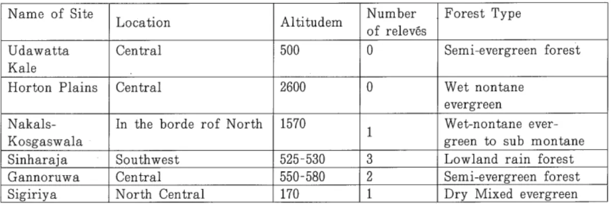
(11) Sri Lanka has a greater biodiversity per unit area than any other country in Asia (Figure 6). The present flora of Sri Lanka is represented by six floristic elements: Sri Lankan, Indo-Sri Lankan, Himalayan, Malayan, African, and pantropic and cosmopolitan (Abeywicrama B. A. 1955). Although the predominant named forms of Sri Lankan plants are present in peninsular India, evidence is found of high concentration of diversity and endemicity. The indigenous flora of Sri Lanka consists of about 7206 species. In the 15th century the Europeans introduced many new plants to the country. Table 4 shows the composition of the indigenous flora of Sri Lanka. About 230 endemic flowering plants are considered a s 'endangered species'. Due to overexploitation, most of the species are facing a danger of disappearance. The Sri Lankan flora demands special attention because of its high degree of biodiversity, endemism, and its vulnerability to habitat destruction.. Field Surveys a t Selected Locations Field surveys were carried out to get a clear idea of forest types of Sri Lanka, their vegetation patterns and other characteristics. After studying the existing literature about forest and vegetation patterns, six locations were selected to carry out field surveys. These six locations were selected to cover the four most prominent forest types available in the country. Seven field relev6s.
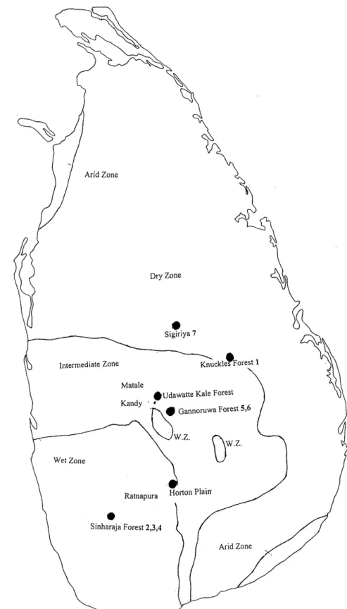
(12) were made in these forests. The field data are summarized in Table 2 below. The locations are shown in Figure 7. Nomenclature in the relev6s follows various references and involved the help of local experts. Table 2 Details of fieldwork. Forest Type. Location. Altitudem. Number of releves. Udawatta Kale Horton Plains. Central. 500. 0. Semi-evergreen forest. Central. 2600. 0. NakalsKosgaswala Sinharaja Gannoruwa Sigiriya. In the borde rof North. 1570. Southwest Central North Central. 525 - 530 550-580 170. Wet nontane evergreen Wet-nontane evergreen to sub montane Lowland rain forest Semi-evergreen forest Dry Mixed evergreen. Name of Site. 1 3 2 1. .. The field relev6s made in each forest are given in Annex 1-7, along with photographs of each location. The relev6s include all the species in the sampling areas, the occurrence and importance of each species, estimated by means of a 'total estimate' (combining abundance and cover degree), and a 'sociability' factor, which shows the horizontal aggregation pattern of the species. Necessary basic environmental data are also recorded, such a s altitude, location, sampling date and year, slope and aspect, general topography, water depth (if standing water is present), soil condition, geological condition and the personnel involved in the field work. The methodology is as explained in Fujiwara, K (1987).. Udawatta Kale This forest, which is located in the heart of the second largest city, Kandy, is the only manmade urban forest in the country. In 1938 the forest department, having obtained authority over the forest, carried out successive planting. Elevation is about 500 m. The area is in the intermediate zone. The trees present were very tall, and climbers could be seen in almost all the trees. The root systems were about 1-2 meters deep. The dominant canopy has tree species Aleurites moluccana, Democarpus longana, Ficus fergusonii,. Gmelina. arborea, Madhuca. longifolia,. Mangifera. zeylanica,. Pometia. exima,. Swietenia macrophylla, Michelia champaca, Filicium decipiens, Artocarpus nobilis and Careya arborea (Greller, A.M. et al. 1980). Predominant canopy consists of Carallia brachiata, Careya arborea, Sticulia balanghas, Vitex altissima, Mesua ferrea, Aleurites moluccana, Adenanthera pauonnia, Syzygium gardineri and Myristica dactyloides. Photo 1 shows the forest area.. Horton Plains Horton Plains is situated in the central hill country. It is the highest plateau in Sri Lanka. Its elevation ranges between 1800 m and 2300 m and encompasses 3162 hectares. It has rolling hills covered with either forest or grassland. The forests could be seen on the hilltops or upper slopes, whereas grassland covers the valleys and lower slopes. The grassland appears to be evenly.
(13) Fig. 7 Location of field surveys.
(14) Photo 1 Udawatta Kale forest reserve. Photo 2 Horton Plains. d like a carpet. The literature says that earlier (1950s) the grassland present wa. inated. single bushy grass species. The land was utilized for potato seed farming carric. in the.
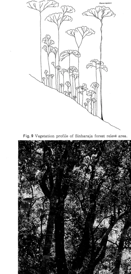
(15) late 1950s and abandoned thereafter. The species that are available now are the species introduced by the manure and vehicular traffic from potato farming (Gunathilaka, C.V.S. 1996). Horton Plains is the watershed for several tributaries that feed the major rivers of Sri Lanka. In 1969 the entire area was declared a nature reserve. The herb species that could be seen are Chrysopogon zeylanicus, Garnotia tectorum and other unidentified herb species. Several tree species could be seen in the grassland. Rhododendron arboreum is the most beautiful and eye-catching tree that could be seen because of its bright crimson flowers. Ulex europeus, Rubus leucocarpus, Rubus ellipticus, Aristea ecklonii and Erigeron karuinskianus are a few of the other plants in the grassland. Species like Indocalamus debilis, Arundinaria densifolia, Aponogeton jacobsenii, and Isolepis fluitans could be seen on the banks of the streams. Some of the tree species, which could be seen in the natural forest are Calophyllum walkeri, Actinodaphne. speciosa,. Syzygium. rotundifolium,. Litsea. sp.,. Vaccinium. simplocifolium,. Symplocos bractealis, Cinnamomum ovalifolium and Elaeocarpus obovatus. Photo 2 shows the forest area and grassland.. Knuckles-Kosgaswela Kosgawela forest is located on the northern side of the central hills. The Knuckles is a forest B.. range dominated by wet montane forests in the upper slopes and crests to semi-evergreen forests in the northern region. Kosgaswela forest shows intermediate characteristics between submontane and semi-evergreen forests. The field relev6 was made in a 30x50 m2 plot. Ten species in the T1 layer, 9 species in the T2 layer, 27 species in the shrub layer of 5 m height, and 7 species in the 0.5 m-high herb layer were identified. Figure 8 gives the vegetation profile of the forest. According to the relev6, the community could be identified a s a Litsea-Palaquium heenmolpedda community. Photo 3 shows the forest area.. Sinharaja Sinharaja Man and Biosphere Reserve is a lowland rain forest located in the southern part of Sri Lanka. It is the sole lowland rain forest in the country which could be considered relatively undisturbed rain forest (Ashton, P.M.S. 1997, Gunathilaka, S. Gunathilaka, N. 1996). It is recognized a s a world heritage site. It covers an area of about 47,370 ha including the forest reserves surrounding it. Based on physiognomic, ecological and floristic criteria, the forest is divided into four categories: Lowland tropical wet evergreen forests with Mesua-Doona (Shorea) formation, submontane tropical wet evergreen forests with Calophyllum-Cullenia formation, submontane patana grasslands dominated by Chrysopogon zeylanicus, and secondary forests. Field relev6s were made a t three locations. The first relevi: was in a plot of 20x40 m" and the other two re1evi:s were in a mantle community along a path. The plot areas of the latter two are 1 . 5 ~ 4and 1 . 5 ~ 3m2 respectively. In the first relev6, three tree species were identified in the super tree layer, which is 43 m high. Seven species in the T1 layer, 8 species in the T2 layer, 18 species in the shrub layer of 4 m height, and 18 species in the 0.5 m-high herb layer were identified. This community could be identified a s a Shorea megistophylla-Shorea stipularis community. Figure 9 gives the vegetation profile of the forest. The mantle communities of the second and third relev6s were selected to get a n idea about the herb layer. The average height of the herb layer of the second relev6 was 1.2 m . Twelve species.
(16) Fig. 8 Vegetation profile of Knuckles Kosgaswela forest relev& area.. Photo 3 Knukles-Kosgaswela relev6 area.
(17) Fig. 9 Vegetation profile of Sinharaja forest relev6 area.. Photo 4 Sinharaja forest relev6 area.
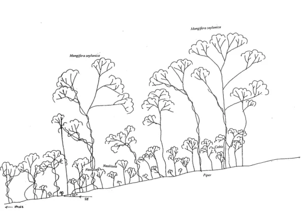
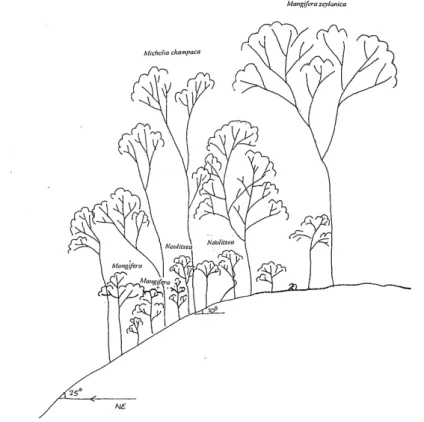
(18) could be identified, and the community could be identified a s Ichaemum-Cleidemia hirta community. Photo 4 shows the forest area. The average height of the herb layer of the third relev6 was about 2 m. Seven species could be identified, and the community could be identified a s Arundinela-Blechnum community. Photo 4 shows the forest area.. Gannoruwa Gannoruwa is situated in the intermediate zone. The forest is disturbed for fuel gathering. Michelia champaca and Syzygium gardneri were identified a s the dominant species in the forest a t lower elevations. The summit area of Gannoruwa Mountain has taller and more massive trees and appeared to be less disturbed. The dominants in this area are Artocarpus nobilis, Mangifera zeylanica, Neolitsea cassia, Pometia tomentosa and Terminalia bellirica (Greller, A.M. et al. 1980). Relevees were made at two locations. The first relev6 was in a 20x50 mZ plot. Six species in the T1 layer, 10 species in the T2 layer, 32 species in the shrub layer of 5 m height, and 15 species in the 1.2 m-high herb layer were identified. The community could be identified a s a Michelia champaca-Mangifera zeylanica community. Figures 10 and 11 give the vegetation profile of the forest. In the releve number two, which was in a plot of 30x30 m2, there were 9 species in the TI layer, 9 species in the T2 layer, 28 species in the shrub layer of 6m height, and 9 species in the 0.5 m-high herb layer. This community also could be identified a s Michelia champahaMangifera zeylanica community. Figure 12 gives the vegetation profile of the forest. Photo 5 shows the forest area.. Fig. 10 Vegetation profile of Southeast elevation, Gannoruwa forest relev6 area 1..
(19) Fig. 11 Vegetation profile of northeast elevation, Gannoruwa forest relev6 area 1.. Fig. 12 Vegetation profile of Gannoruwa forest relev6 area 2..
(20) Photo 5 Gannoruwa relev6 area I. Sigiriya Sigiriya is located in the northern part of the island. The civilization of the island was started in the northern part. Therefore all the forests in this area were cleared for cultivation and human settlement. The forest could be categorized a s dry mixed evergreen secondary forest (Cramer L.H. 1993). A relev6 was made in a plot of 15x20 m2. Three species were identified in the TI layer, 8 species in the T2 layer, 25 species in the shrub layer of 2.5 m height, and 15 species in the 0.2 m-high herb layer. The community could be identified a s a Pterospermum canescensEugenia bracteata community. Figure 13 gives the vegetation profile of the forest. Photo 6 shows the forest area.. Conclusion The study tour to learn vegetation types and characteristics of Sri Lanka was planned to get the maximum knowledge possible during the short duration of the visit. The itinerary allowed the group to get a comprehensive knowledge of vegetation patterns, their sustenance and also degradation in various types of forests and other areas throughout the country. The vegetation in Sri Lanka has unique characteristics among South Asian countries. It has a greater diversity for the size of the country than any other country. The main reason for this is the huge difference in altitude, related climatic conditions and rainfall patterns in the island. The amount of natural forest in the country is deteriorating rapidly..
(21) Photo 6 Gannoruwa releve area 2. The forest garden concept used by the majority of Sri Lanka's households contributes much to the abundance of vegetation in the country. The forest garden, which is unique to Sri Lanka, is located immediately around the owner's house. Throughout the year it provides a wide variety of food, fuel, fodder, wood, medicinal and cash crops including coffee, bananas, a s well a s a cool and pleasant living environment. Structural characteristics of the forest garden, including its high density and species diversity, are comparable to measures from natural forests in similar elevations and climates. In some parts of the island, especially in hilly areas of the central region where tea plantations were established and in the dry zone where shifting cultivation and paddy cultivation were carried out, fallow areas or abandoned areas could be seen. Some parts were exposed to firing caused by natural causes or human activities. Creating buffer zones between the areas where human activities are carried out and the forest will be a practical solution to prevent the fires. Further studies should be made about the vegetation pattern of the country to learn about successful vegetation patterns a s well a s forest degradation and methods of improving and preventing the degradation.. Acknowledgment We are greatly indebted to the following personnel who helped us from initial arrangements up to the successful completion of our fieldwork: Professors Savithri and Nimal Gunathilaka (University of Peradeniya) , Ms. Mano Basnayaka (University of Peradeniya) , Mr. J.C.Jayalath and Mr. J.P.Padmasiri (National Water. Supply & Drainage Board, Kandy). Illangasinghe. We also thank Professor Elgene 0.Box for editing this paper.. and. Mrs.. Dharma.
(22) Fig. 13 Vegetation profile of Sigiriya forest relev6 area.. Photo 7 Sigiriya releve area. References In, P. M. S. 1997. Restoration of a Sri Lankan forest: using Caribbean pine. 'Pinus.
(23) caribaea' as a nurse for establishing late successional tree species. Journal of Applied Ecology. 34: 915-925. Ashton, M. S., S. Gunathilleka, N. de Zoysa, M. D. Dassanayake, N. Gnatilleke & S. Wijesundera 1997. A Field Guide to the Common Trees and Shrubs of Sri Lanka. Sri Lanka: WHT (Pvt.) Limited. 430 pp. Cramer, L. H. 1993. A Forest Arboretum in the Dry Zone. Institute of Fundamental Studies, Kandy. 241 pp. Fujiwara, K. 1987. Aims and methods of phytosociology or vegetation science Papers on plant ecology and taxonomy to the memory of Dr. Satoshi Nakanishi, pp. 607-627. The Kobe Geobotanical Society. Greller, A. M., C. V. S. Gunathilaka, I. A. U. N. Gunathilaka, & S. Balasubramaniam. 1980. A Phytosociological analysis of three stand forests in the vicinity of Peradeniya, Kandy Districts. The Sri Lanka Forester, 14 (3/4): 153-161. Greller, A. M. & S. Balasubramaniam 1980. A preliminary floristic-climatic classification of the. forests of Sri Lanka. The Sri Lanka forester, 14 (3/4): 163-168. Gunathilake, I. A. U. N. & C. V. S. Gunatilake 1991. Natural Forests of Sri Lanka. Sri Lanka: Department of Botany, Faculty of Science, University of Peradeniya. 24 pp. Gunathilaka, C. V. S 1996. A Nature Guide to the World's End Trail, Horton Plains, Sri Lanka: Faculty of Science, University of Peradeniya. 48 pp. Gunatilaka, S. & N. Gunatilaka 1996. Sinharaja, World Heritage Site, Sri Lanka. Sri Lanka: Natural Resource, Energy & Science Authority of Sri Lanka 20 pp. Kottegoda, S. R. 1994. Flowers of Sri Lanka. Sri Lanka: Unigraphic (Pte) Ltd., 245 pp. Malcolm, F. B. ed. 1991. Natural Resources of Sri Lanka Conditions and Trends. Sri Lanka: A report printed for The Natural Resources, Energy & Science Authority of Sri Lanka. 280 pp. Mitchel, R. J. & L. K. D. Tilakaratne 1980. Understorey vegetation structure of the Sinharaja tropical wet evergreen forest type. The Sri Lanka Forester, 14 (3/4): 181-182. Ratnayaka, H. D. & S. P. Ekanayaka, 1995. Common Wayside Plants of Sri Lanka. Sri Lanka: Royal Botanic Gardens, Peradeniya. 192 pp. Somasekaram, T., L., A. G. Perera, M. P. Perera, M. B. G. de Silva, M. M. Karunanayake & D. S. Epitawatte eds. 1982. The National Atlas of Sri Lanka. Sri Lanka: Survey Department of Sri Lanka. 141 pp. Somasekaram, T., M. P. Perera, M. B. G. de Silva, H. Godellawatta eds. 1997. Arjuna's Atlas of Sri Lanka. Sri lanka: Arjuna Consulting limited. 220 pp..
(24) Appendix 1 Vegetation type: sub-montane evergreen forest Relevt Number: SL-1 Location: Nakals Kosgaswela Elevation : 1570 m CityITown : Rattota. Date: 0 1.04.98. -. Height. Country : Sri Lanka. Cover Slope: Aspect: Relevt size:. 5 SW 30 x 50 m2. No. o f spp.: 36 spp.. TI 2.2 2.2 2.2 1.2 1.1. +. 1.1 2.2 1.1 1.1. Palaquium heeninolpedda Vitex altissima Dimocarpus longan Litsea gardneri Filicium decipiens Allobotris serenicus Terminalia bellirica Syzygium cwuiili Pterocarpus nlarsupiwn Semecarpus gardneri. 2.2 2.2 2.2 2.2. +. 1.2 1.2 1.2. + + + +. +. T2. +. 1.2 1.2 2.2. 2.2. +. 2.2 2.2. +. + +. H. S. Filiciurn decipiens Gonphia serrata Dimocarpuslongan Piperceylanica Litsea gardneri Syzygium cumini Benkara sp. Nothopegia beddomei Mangifera ze&~ica. + + + + + +. + + + + + +. Palaquium lreenmolpedda Miliusa indica Calamus zelanicus Gonphia serrara Psychotria sp. .Jasminum angustifolium Dinnocarpl4.s longan /,itsea gardiieri Piper ceylatrica Hiptage bengalensis Myristica dactyloides Syzygium gardneri Semecarpus nigro-viridis Garcinia morella Litseasp. Plerocarpus marsupium Pterospermum canescens Nothopegia beddomei Mangifera zeylanica Carissa spinarum Syzygium aqueum Unknown 1 (Sapotaceae?) Unknown 2(Annonaceae?) Calophyllum romentosa Syzygium cumini Aglaia roxbergiana Noropoditis poetidia. 1.2. + + + + +. 1.2. Calamus ze1anicu.r Palaquium heenrnolpedda Lilsea sp. 1 Drypetes sp. Diospyrossp. Ardisia sp. Litsea gurdtieri.
(25) Appendix 2 Relevl Number: SL-2 Location: Sinharaja CityITown : Ratnapura Height. Vegetation type: Lowland rain forest. Date: 03.04.98 Country : Sri Lanka. Elevation : 530 m. Cover Slope: Aspect: Relev6 size:. 20. NW 20 x 40 m2. No. o f spp.: 40 spp.. 2.2 2.1 1.1. Shorea megistophylla Shorea sripularis Dalbergia pseudosico. T1 2.2. +. 1.2 1.2 1.1 2.2 2.2. Shorea megistophylla Syzygium makul Cullenia ceylanica Cullenia rosayroana Shorea disticha Shorea trapezifolia Mesuaferrea. T2 1.2 1.2 1.1 1.1 2.3 2.2. + +. H. S. Emergent. 2.2 3.2 1.2 2.2 2.3. + +. 2.2 1.2 1.2. + +. + + + +.2. Sliorea niegistophylla Shorea disticha Shorea trapezgolia Semecarpus nigro-viridis Mesuaferrea Humboldtia laurrfoia Syzygium makul Cullenia rosayroana. +. 1.2. + +. Memecylon varians Shorea megisrophylla Palaquium sp. Camnosperma zeylanica Syzygium makul Psychotria sp. Bhesa ceylanica Callophyllum bractearum Humboldtia laurifolia Memecylon porceren Anisophyllea cinnaomomoides Lepisanthes sp. Shorea stipularis Palaquium petiolare Dalbergia pseudosico (climber) Ficus sp. (climber) Vitex altissima Mesuaferrea Agrotisrachys hookeri Schumacheria castanerfolia. 1.2 1.1 +.2. +. 1.1. +. 1.1 1.1. + + + + +. + + + + 1.1. Rumora sp. Calamussp. Adiandtum sp. Dalbergia pseudosico Pandanus sp. Artobotrys seranica Psychotria sp. Syzygium makul Filicium decipiens Lasianthus sp. Zingiberaceae sp. Cullenia ceylanica Chaetocarpus chestinojlia Meinecylon sp. Ptilopteris inaximowiczii Mesuaferrea Cleinia roseiana Agrosr isfachys sp..
(26) Appendix 3 Vegetation type: Lowland rain forest Relevt Number: SL-3 Location: Mantle community along a path, Sinharaja Elevation : 530 m City/Town : Ratnapura Height. Cover Slope: Aspect: Relevt size:. No. of spp.: 12 spp. I. H 5.5 3.4. +. +. + + + + + + + +. Palaquium grande Cleidemia hirta Shorea stipularis Nepenrhus distifolia Schumacheria casraneifolia Humboldtia laurifolia Mesua pulchella Hydnocarpus octandra Ichaemum sp. Osbeckia ocrandra Melastoma malabathricum Hedyotis sp.. 5 NE 1.5 x 4 mZ. Date: 03.04.98 Country : Sri Lanka.
(27) Appendix 4 Vegetation type: Lowland rain forest RelevC Number: SL-4 Location: Mantle community along a path, Sinharaja Elevation : 530 m CityITown : Ratnapura. Height. Cover Slope: Aspect: Relev6 size:. No. of spp.:' 7 spp.. H 2.2. +. 3.4 3.3 2.2 1.2 1.2. Arundinelasp. Hedyofisfruticosa Dichanopferis sp. Blechnum orientale Malabaceae sp. Nepenthus distrifolia Apocynaceae sp. Rocky. 5 NE 3 x 5 mZ. Date: 03.04.98 Country : Sri Lanka.
(28) Appendix 5 RelevC Number: SL-5 Location: Gannoruwa CityITowt : Kandy. Height. Date: 04.04.98. Vegetation type: Semi-evergreen forest. Country : Sri Lanka. Elevation : 550 m. Cover Slope: Aspect: RelevC size:. 15 - 10" SW 15" SE 10" 20 x 50 mZ. -. No. ofspp.: 55 spp.. 2.2 3.3 1.1. + +.2 2.1. Mangfera zeylanica Michelia clianipaca Schefflera stellata (climber) Zizyphus oenoplia Dalbergia pseudosico Swietenia macrophylla. T2 1.1 2.2 1.1 1.2. +. 2.2 1.1 1.1 1.2 1.1. H. S. TI. Nofhopegia heddomei Dimocarpus longan Swietenia mahogani Artocarpus integurfolia Alstonia n~acrophylla Pometia pinnata Meliosma simpliclfolia Terpinia maraberica . Arrocarpus nobilis Mallotus philippensis. 1.2. + +. 1.1 2.2. +. 1.1 1.2 1.1 1.1 1.1. +. I.1 1.1. +. 2.2 1.2 1.2. + +. +. + + + + +. 1.1 2.2 +.2. + + +. Nothopegia beddomei Elaeocarpus sp. Nothopidialis po f ida Litsea glutinosa Rubiaceae sp. Swietenia macrophylla Ardisia paniculata Dimocarpus longan Atalantia ceylanica Morea paniculbta Neolilsea cassia Cacao sp. Piper sylvesta Lepisanthes erecta Aglaia elaeagtioidea Cinnanzornum sp. Bhesa ceylanica Pavetta indica Glochidion gardneri Celtis wightii Alstonia scholaris Filicium decipiens Hydrocarpus venenata A rtobotrys cerenica Syzygium operculaturn Mallor us philippensis Turpinia malabarics. Pterospern~umcaneidens Diospyros walkeri Phyllanthus indicus Micromelum minurum Gonphia serrata. 1.1 2.2 +.2. + +. 1.1. + +. 1.1 1.1 +.2. + +. +.2 +.2. Piper sylvesta Pterospernzunz canescens Micromelunz minuturn Pavetfa indica Coffea arabica Neolitsea sp. Diospyros sp. Aporusa lanceolata Neolifsea cassia Sapindaceae sp. Cyperaceae sp. Pteris semipinnata Oplisnzenus sp. Gramineae sp. Adiantum sp..
(29) Appendix 6 Releve Number: SL-6 Location: Gannoruwa City/Town : Kandy Height. Country : Sri Lanka. Elevation : 530 m. Cover Slope: Aspect: Releve size:. No. of spp.:. Miclzelia champaca Mangfera zeylanica I;ilicium decipiens Terminalia bellirica Enteda sp. Arrocarpus integ$olium Arrobotrys serenica Rubiaceae sp. (climber) Vitex altissima. 1.2. +. +. +. +.2 +.2. 3.3 1.1. + +. 2.2. +. + + 1.1. 1.2 2.2. H. S. +. T2 1.1 2.3 2.2. 30" NW 30 x 30 m2. 53 spp.. TI 3.3 2.2 1.2 1.1 +.2 1.1 2.2 +.2 1.1. Date: 04.04.98. Vegetation type: Semi evergreen forest. + Garcinia morella Din1ocarpuslongan Zityphus oenoplia Neolitsea cassia Pometia pinnata Meliosma simplicfolia Atlantia ceylanica Mallotus philippensis Filicium sp.. 1.2. 2.2 1.1 1.2 1.2. +. 1.2. +. +.2. +. +.2. +. +.2. + +. Pavetta indica Swielenia macrophylla Hydnocarpus venenata Syzygium operculatum Aglaia elaeagnoidea Menispennaceae sp. Neolitseacassia Ardisia paniculafa Diospyros walkeri Lepisanthes erecta Micronzelun~minutum Lilsea glutinosa Filicium sp. Rhesa ceylanica Nothopegia beddomei CoSfea arabica Aporusa lanceolata Gonphia serrata Cinnamonzum sp. A tlantia ceylanica Alstonia n~acrophylla Pterosper~numcanescens Celtis utightii Pepper sp. Arlobotrys serenica Ziziphus oenoplia Lilsea glulinosa Morea paniculala. 1.1 2.2 +.2 1.2. +. + + +.2. +. Micro1nelur71sp. Neolitsea sp. Adiantwn sp. Paricasp. Pteris semipinnata Pepper sp. Lepisanthes erecta Cyperaceae sp. Anomelra sp..
(30) Appendix 7 RelevC Number: SL-7 Location: Sigiriya CityITown : Da~nbulla. Height. Vegetation type: Dry mixed evergreen forest. Date: 05.04.98. Elevation : 170 m. Country : Sri Lanka. Cover Slope: Aspect: Relevt size:. 0 15 x 20. No. of spp.: 45 spp.. S. TI . 2.1. 2.1 1.2. Schleichera oleosa Pterospennwn caizesceizs Bauhinia raceinosa. 3.3 1.2 2.2 2.2 1.1 1.2. T2 1.2 1.2 2.2. +. 2.2 1.2. +. 2.2. He1ictere.s isora Compositae sp. (climber) Rauhinia racernosa Cassiafistula Syzygiuln curnini Rridelia retusa Allophylus cobbe Pterospern~uincanescens. + + + +. 1.2. + +. ,. +.2 1.1. +. 1.2. +. + 2.2. 1.2. +. 3.3. + +. H Eugenia bracteata lbddalia asiatica Croton laccijer Phyllan~ h upolyphyllus s Compositae sp. (climber) Limoniaferonia Lantana camara , Lepisanthes tetraphylla Eupatorium odoratun? Menispermum Baukinia rademosa Zizyphus rhanznacia Zizyphus oenoplia Flacourtia indica Apocynaceae sp. (climber) Unknown 1 Clausena irzdica Unknown 2 Unknown 3(climber) Aglaiaelaeagonidea Flueggea leucopyrus Dalbergia pseudosis Pterospennum canescens Flueggea leucopyrus Jasnzinunl sp.. 3.4 2.3. +. +.2 1.2 1.1. +.2 2.2. + +. +. + + + +. Paspalurn sp. Cyperaceae sp. Flacourtia sp. Carissa spinarunz Croton laccrfer Phyllanthus polyphyllus Menispermum sp. Flueggea leucopyrus Cassiafistula Asparagus racenzosus Vitex altissilna Chloroxylorz su~ietenia Streblus asper Sapotaceae sp. Fluggea sp.. 1.
(31)
図
+7

関連したドキュメント
This paper develops a recursion formula for the conditional moments of the area under the absolute value of Brownian bridge given the local time at 0.. The method of power series
We present sufficient conditions for the existence of solutions to Neu- mann and periodic boundary-value problems for some class of quasilinear ordinary differential equations.. We
This class of starlike meromorphic functions is developed from Robertson’s concept of star center points [11].. Ma and Minda [7] gave a unified presentation of various subclasses
In Section 13, we discuss flagged Schur polynomials, vexillary and dominant permutations, and give a simple formula for the polynomials D w , for 312-avoiding permutations.. In
Analogs of this theorem were proved by Roitberg for nonregular elliptic boundary- value problems and for general elliptic systems of differential equations, the mod- ified scale of
Then it follows immediately from a suitable version of “Hensel’s Lemma” [cf., e.g., the argument of [4], Lemma 2.1] that S may be obtained, as the notation suggests, as the m A
Correspondingly, the limiting sequence of metric spaces has a surpris- ingly simple description as a collection of random real trees (given below) in which certain pairs of
[Mag3] , Painlev´ e-type differential equations for the recurrence coefficients of semi- classical orthogonal polynomials, J. Zaslavsky , Asymptotic expansions of ratios of
