central Ryukyu Island Arc, southern Japan
著者
TERRY James P.
journal or
publication title
南太平洋海域調査研究報告=Occasional papers
volume
42
page range
25-34
別言語のタイトル
琉球諸島、与論島における石灰岩に関する地形学的
研究
URL
http://hdl.handle.net/10232/10125
25
Limestone geomorphology on Yoron Island,
central Ryukyu Island Arc, southern Japan
James P. TERRY
Geography Department, the University of the South Pacific
Abstract
Yoron-jima is a small carbonate island lying in the Ryukyu Island Arc of southern Japan. Thf island was raised above sea level in the Quaternary period and most of the 21 km2 land area is underlain by carbonate rock types associated with the regionally important Ryukyu Limestone Group. The island's landscape is characterised by a variety of limestone geomorphic features such as low angular cliffs, terraces and escarpment at different elevations, vadose caves, and many surface depressions. The occurrence of these formations is determined both by structural influences associated with island uplift and variations in the exposure of different carbonate rocks. The main aim here is to describe Yoron's many dolines and interpret their uneven spatial distribution. Some areas covered by unconsolidated Holocene deposits are almost absent of dolines. Elsewhere, doline clusters are observed on the low-lying westerr peninsula and in the northern segment of the island. Small dolines (average 89 m) tend to be shallow with regular elliptical morphologies, and are densely clustered (27 per km2). These have formed on a low elevation marine terrace where there has been minimal structural deformation of the coral limestone bedrock. In contrast, larger (average 158 m) and deeper dolines (5-10 m), more often with irregular or star-shaped plans, are developed in association with major faults or outcrops of rhodolith limestone geology. Aggressive dissolution has also produced large elongated dolines in some coastal positions where tidal fluctuations control the salinity and surface height of the water table. Correlations with depressions elsewhere in the Ryukyu Islands on similar geology suggest that limestone solution rates on Yoron may be 5- 10 mm/1000 yrs. 琉 球 諸 島 、 与 論 島 に お け る 石 灰 岩 に 関 す る 地 形 学 的 研 究 ジ ェー ム ス P. テ リー 南 太 平 洋 大 学 (元鹿 児 島 大 学 多 島 圏 研 究 セ ン タ ー 客 員 教 授) 与論 島は琉球諸 島に属 す る石灰岩 か ら出来 た小 さな島で ある。 島は第四期 に隆起 して でき、全面 積21㎞2の ほ とん どが炭酸 塩の岩 ででき あが ってい る。島の景観 は多岐 にわ たる石灰岩 の地形に よ り 特徴づ け られ る。 例 えば、高台や洞窟、陥没 した地 域に見 られ る崖や段丘や急斜面 であ る。 これ らの 地形 は島の隆起に伴 う構造 と異なる種類 の炭酸 塩の岩 の露 出によ り形成 され る。 この論 文の 目的は与 論 島に見 られ る多 くの種類 の ドリーネ の説 明 と一様 でないそ の分布 の解 釈 を行 うこ とで ある。 強 固でない現世 の沈殿 物で覆 われ てい る地域 には ドリーネ はほ とん ど存在 しない。島 の西部 の半 島 と北部 には ドリーネの塊がい たる所 に見 られ る。小 さな ドリーネ(平 均89m)は 楕円形状 で薄 く密 に(27/km2)見 られ る。 これ らは隆起の低い海洋棚 田で形 成 され る。 これ に対 して大 き くて(平 均 158m)深 い(5-10m)ド リーネ は主な断層か石灰岩 の露 出に よ り形成 され る。 著 しい溶解 は大き く て長細 い ドリーネ を特 定の沿岸域 で形 成す る。 おそ らく与 論島に見 られ る石灰 岩の溶解速 度は5-10 mm/1000年 と考 え られ る。
Introduction and Physical Setting
Yoron Island is a small raised limestone island (Figure 1) in the Nansei-Shoto chain of islands of south west Japan. This chain is part of a volcanic island arc. The geology mainly comprises Miocene to Holocene age carbonate rocks and deposits, occurring as a series of low relief marine terraces uplifted to different elevations above sea level. The island is partially karstified, although the distribution of carbonate features across the island is uneven. Yoron therefore presents an interesting opportunity for the study of geomorphology on a small emerged carbonate island. The aim here is to describe the geomorphic features of Yoron Island and to determine their occurrence in terms of geological influences.
Yoron's location is 27°01'N, 128°24'E, in the centre of the Nansei-Shoto group of islands, approximately mid-way between the small limestone island of Okinoerabu to the north east and the large volcanic island of Okinawa to the south west (Figure 2). The shape of the island resembles an angel fish, with a narrow peninsula at the western end. The circumference measures approximately 23 km and the land area covers just 21 km2. The resident population numbers around 6000.
Most of the native sub-tropical forest cover has been cleared. Sugar cane farming and beef cattle grazing are now the two predominant agricultural land uses. Yoron's climate is subtropical, with a mean annual temperature of 23°C and an annual precipitation of approximately 2200 mm. Typhoons often bring torrential rain during the summer and early autumn seasons from July to September. Since Yoron's bedrock geology mostly comprises permeable carbonates, there are no permanent surface watercourses. Within the limestone bedrock beneath the surface, there exists a large freshwater aquifer 30-40 m thick (Momii et al. 2001). The hydrological balance is estimated by Momii et al. (2001) as follows:
evapotranspiration 45%, runoff 15%, groundwater recharge 40%. Geology
The Nansei-Shoto islands are formed as the Ryukyu Island Arc, so the name Ryukyu Islands is also used in the literature to refer to this chain of islands. The Ryukyu Arc is produced as the result of the northwest movement of the Philippine Sea Plate and its subduction under the Eurasian continental plate at the Ryukyu Trench. Yoron exists as a series of raised Pleistocene limestone terraces overlying folded and faulted Mesozoic basement rocks of various lithologies associated with volcanism. Odawara and Iryu have drawn the latest geology map of the island in 1999 (Figure 3). Their work supersedes previous geology maps
and makes major revisions to earlier limestone stratigraphy.
The oldest surface rocks on Yoron are of Mesozoic age, known as the Ritcho Formation. These are strongly altered slates, volcanic greenstone (diabase), tuffs, sandstones and detrital limestones, which crop out in two separate areas in the south and south east of Yoron. Lying unconformably above are Pleistocene age limestones of the Yoronjima Formation (equivalent to the Gusuku and Nama Formations described by Omura 1972). This is the predominant carbonate sequence on Yoron and occurs over approximately 70% of the island, with a maximum thickness of 55 m. From the evidence of stratrigraphic position and age-diagnostic fossils, Odawara and Iryu (1999) suggest that the Yoronjima Formation may be correlated with the main Ryukyu Group limestones, which are widely distributed throughout the Ryukyu
27
Figure 1. Oblique aerial photo of Yoron Island. Photo by Kihachiro Kaneko
southern Japan Ryukyu Island
Yoron
Island
ArcFigure 2. Location map of Yoron Island in the Ryukyu Island Arc chain
Islands (Nakamori et al. 1995). On the nearby islands of Okinoerabu and Tokunoshima, the Ryukyu Group limestones range in age from 390 to 890 ka.
The Yoronjima Formation is extensively exposed on Yoron and has a basal unit of conglomerate of angular pebbles, cobbles and boulders (Omura 1972). The upper unit can be broadly differentiated into two types of carbonate rocks - proximal coral limestone and distal rhodolith limestone (algal ball limestone). The latter has more than 20% concentration by volume of rhodoliths (algal balls), deposited in an insular shelf environment at 50-100 m depth. Distal rhodolith limestone is a hard, massive limestone, and is the bedrock in the north east segment of the island. The proximal coral limestone is a massive indurated limestone, showing framework structures of hermatypic corals and other fossils of coralline algae, foraminiferans, molluscs, bryozoans and echinoids (Omura 1972). The coral limestone formed as a reef flat and fore reef slope 0-50 m deep. It occurs on the western peninsula and as a broad band 1-11/2 km wide traversing NNW-SSE across the centre of the island. Several normal faults run NNW-SSE and W-E across the latter area, and are expressed as a low escarpment in the island's topography (see below). Faulting is probably still active.
Holocene beach and alluvial deposits are found covering low lying areas behind Chahana Bay and Oganeku Beach. Limited exposures of cemented beachrock also occur in several coastal locations.
Geomorphology 1. Reefs and Coastline
Throughout the Ryukyu Islands, Holocene reefs began forming on older carbonate foundations around 8,500 to 8,000 BP. Yoron's Holocene reefs appear to have grown at 1-3 mm a year, and reached modern sea level about 5,000 years ago (Kan et al. 1995). The thickness of Holocene reef deposits ranges from 3.0 to 15.0 m. Today, Yoron is fringed by coral reefs around almost the entire coastline.
Yoron's coastal geomorphology is mostly a rocky coast of low weathered limestone cliffs (Figure 4). Several bays are sculpted along the coast in the south and west of the island, occupied by white sand and gravel beaches of coralline materials. Along the east coast is the island's longest sandy beach, called Oganeku Beach, which is popular with tourists in summer. This beach is almost straight and 2 km long. Offshore 1.5 km from Oganeku is Yurigahama Beach. This is a actually a lagoon shoal which becomes exposed at low tide and is famous throughout Japan for its composition of `star sand' — star-shaped sand grains made from the calcareous tests of dead plankton.
2. Limestone Plateaux, Escarpment and Ridge
Yoron Island was slowly uplifted above sea level during the Pleistocene, and simultaneously eroded and flattened to produce the present smooth topography (Omura 1972). Tilting of Yoron during the Holocene also probably occurred as a result of expansion of the nearby back-arc basin called the Okinawa Trough (Kawana 2001). Thus, inland Yoron can be divided into three main geomorphic zones, reflecting the influences of uplift and structural geology. The western peninsula and the northern segment are flat limestone plateaux, between 10 m and 30 m above sea level. Traversing the southern part of the island from NNW to SSE is an escarpment occurring along a pair of parallel fault lines. The scarp slope
29
rises to 50-90 m elevation. The highest point of the island at 97 m elevation lies along the top of the escarpment. Ephemeral streams drain the area below and to the west of the fault escarpment into Haki Bay and Chahana Bay. East of the top of the escarpment is an undulating area of low hills, which gradually lose altitude towards the east coast of Yoron. Inland of the eastern coast is an area of Holocene coralline deposits forming low relief dunes. The subdued relief of low hills and dunes in the eastern segment is broken by a narrow arcuate ridge of outcropping reef limestone between Nama and Demo, called Uro Yama. The ridge is 20-100 m wide, rising 10-20 m above the surrounding terrain.
3. Caves
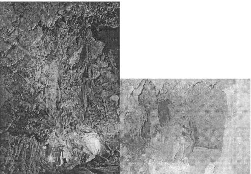
Along Yoron island's coastal cliffs are numerous small sea caves which have been exposed by marine erosion. Most of these simple caves are rock overhangs or notches found at different heights on cliff faces and were cut by wave action. Inland from the coast, several vadose zone caves are accessible from the surface. Although there are few written accounts of any deep underground expeditions, an expedition report by Torimuri (1998) mentions that there are 13 known caves on Yoron, and Arakawa et al. (1993a) suggest that limestone caves sit at 5 different levels. The best known examples are two show caves open to tourists in the south of Yoron, at Akasaki and Gusuku. The entrances to both are cut in outcrops of coral limestone. Akasaki has a large natural vadose chamber decorated with stalactite formations (Figure 5). The cave at Gusuku, called Yagoo Cave, has small passages at several levels. Near the surface the cave floor is dry, sandy and irregular with large blocks of limestone, presumably derived from the ceiling as successive cave levels were cut or collapsed to lower levels. In 1997, Torimuri's team of speleologists explored deeply into this system. Yagoo proved to be the longest cave so far discovered on Yoron, measuring 1426 m long with 6 exits. In the lower section, much of the cave had low ceilings and was difficult to navigate, with a wet and muddy floor.
Arakawa et al. (1993b) collected many speleothems from five different horizontal caves at several terrace levels. These were dated using the Electron Spin Resonance (ESR) method and all except one speleothems sample gave ages less than 25,000 BP. The explanation Arakawa et al. proposed was that limestone solution on Yoron is rapid because the climate is sub-tropical, the limestones very porous, and crustal movements are active. This leads to one cycle of cave formation occurring in less than 30,000 years. Hence, speleothems that formed before 25,000 BP collapsed and disappeared with the last cycle of cave development.
4. Surface Depressions
The Geographical Survey Institute of Japan (1976) has produced a detailed topographic map of Yoron at 1:25,000 scale. This map was used here to examine the distribution and size of depression features across Yoron. In addition, fieldwork on Yoron was carried out in December 2003 to examine the characteristics of various individual depressions.
In the central west of the island is the largest surface depression on Yoron, oriented in a N-S direction (Figure 6). This 2 km long linear depression appears to be polje-type feature, but closer inspection of the local geology shows that it is bounded by gently dipping rocks on the western side and on the east by the 10-20 m high Uro Yama arc-shaped ridge of reef limestone described earlier. Therefore it is probably best explained as topographic feature, although karstic solution is occurring at its base.
Figure 4. Left: Low limestone cliffs and pocket beaches on the south coast of Yoron s western peninsula. In the background is the scarp slope of a NNW-SSE fault escarpment. This forms the major topographic feature on the island and attains a maximum elevation of 97 m. Right: View of the south coast from the top of the limestone escarpment.
Figure 5. Left: Large cavern decorated with speleothems inside Akasaki Cave (Source: Idemura 1973). Right: Dry vadose chamber in Yagoo Cave, Gusuku.
31
The map in Figure 6 shows that Yoron has many doline-type solution depressions, but that their spatial distribution over the island is very uneven. Concentrated doline swarms occur in some areas whereas elsewhere dolines are absent. The southern and eastern segments of the island, as well as the centre of the island, are virtually doline-free. In the east, the lack of dolines may be explained by bedrock porosity and hydraulic conductivity. Here, Momii et al. (2001) monitored groundwater fluctuations in several boreholes as part of their study on tidal influences on the freshwater aquifer. They noted that the relatively low permeability of the bedrock is influenced by the presence of unconsolidated clay contained in pores. Another factor for the lack of dolines in the two areas of Holocene beach and alluvial deposits (inland of the east coast and west of the escarpment) is that these unconsolidated coralline materials are less suitable for retaining doline structure, compared to hard and jointed bedrock in adjacent areas. Dolines are also absent on the two outcrops of Mesozoic basement rocks (slates, volcanic greenstone and sandstone) in the south east and south west sectors of the island.
Elsewhere, there are two notable areas where doline swarms are observed, although these areas differ in terms of doline sizes and cluster density. The smaller cluster, but the one with the highest concentration of dolines, occurs on Yoron's western peninsula. This is a low lying plateau of Yoronjima coral limestone, 5-20 m above sea level. The peninsula has 71 individual dolines in an area of 2.6 km2. The cluster density averages 27 dolines per km2. During fieldwork, it proved impossible to measure doline depths or side wall angles because they tend to contain good accumulations of soil and are therefore farmed with sugar cane. Others have been mechanically excavated and lined, to be used as water reservoirs for sugar cane irrigation (Figure 5). However, most of the dolines on the peninsula were observed to be simple elliptical, shallow, saucer-shaped features, less than 4 m in depth. The mean diameter of doline long axes is 89 m, generally without a large range in size of individuals from this average (Table 1).
The other important area of doline depressions is in the north of Yoron. The bedrock here comprises both coral and rhodolith limestones. The landscape is an area of low hills with gentle topography, 10-50 m above sea level. Figure 6 shows that there are fewer dolines here, with a clustering density of 7 dolines per km2. However, these are generally larger features compared to the western peninsula. This area also has the deepest dolines on Yoron — those formed along the base of the fault escarpment where solution is more active reach 5-10 m in depth. Measurement of 39 dolines in the northern area gives a median size of 158 m. The average size is skewed by two sub-sets of large dolines within the population. Several large dolines are those with star-shape or irregular plans, rather than the more usual elliptical morphology. Star-shaped dolines are produced where solution has caused several smaller doline perimeters to coalesce into a single depression. These occur most often in the north east of Yoron on the rhodolith limestone, suggesting that this rock type is more soluble than the adjacent coral limestone. Another sub-set of larger dolines is a chain of elongated depressions formed along the north and east coasts. Since the coastline is the groundwater aquifer transition zone between fresh and salt water, weathering at the base of these dolines is probably enhanced by the more aggressive solution typical at the brackish mixing zone between the fresh groundwater lens and seawater (see Gillieson 1996). In addition, Momii et al. (2001) observed that the coastal zone of the aquifer is strongly affected by tidal fluctuations. Thus bedrock solution and doline formation is encouraged by the vertical movement of the aquifer surface with every tidal phase.
Table 1. Size of dolines on Yoron Island 287 Diameter(m)e Western 108 across Peninsula 82 enclosing ross e 74 contour Northern 63 592 Area 132 94 254 101 80 69 63 444 127 8! 161 99 79 69 63 406 124 82 152 95 79 67 63 374 109 75 151 95 77 67 62 352 105 71 150 91 76 66 62 331 104 70 141 90 76 65 62 276 103 70 141 90 76 65 57 269 103 70 133 88 76 65 51 185 99 66 133 86 76 63 51 165 99 63 127 86 76 63 49 153 94 63 117 85 76 63 48 147 94 62 114 82 76 63 46 138 94 61 112 82 74 63 44 110 Mean 89 158 M edian 76 103 Stand ard Deviation
Mode 64 42
94 138
Figure 7. Top left: Polji-like feature in the centre of Yoron, cultivated with sugar cane. Top right: Typical small shallow doline on Yoron; most dolines are used for agriculture. Bottom: Excavated and lined doline (left) to be used as a water reservoir for irrigation (right).
33
The dolines on Yoron are comparable with those on nearby Okinoerabu Island, which lies 27 km to the north east of Yoron and has similar uplifted Pleistocene geology of the Ryukyu Group limestones. On Okinoerabu, Maekado (1984) examined the shape of 10 dolines at 30-40 m above sea level. The plan view of Okinoerabu dolines was found to be circular or elliptical, with cross-sections generally bowl-shape. The average measured long diameters of doline mouths was 57 m and doline bottoms was 43 m (Ryukyu University 1976). Doline sidewall angles range 10•‹-26•‹ and depths 1.6-5.1 m. Using the 313— 625 ka age range for the
limestone determined by electron spin resonance by Koba and Nakata (1981), Maekado (1984) estimated solution rates to be 5.0-9.9 mm per 1000 years.
Conclusions
Yoron is a small carbonate island in the central Ryukyu Island Arc, formed by the Quaternary uplift and emergence of coral reefs and associated carbonate rocks. The sub-aerial geology therefore comprises an interesting range of lithologies, including Pleistocene fossil reefs
, rhodolith (algal ball) limestone and partly cemented Holocene coralline sands and gravels . The landscape developed on these carbonate sequences has a variety of geomorphic features
, such as low limestone cliffs, an inland escarpment-plateaux-ridge complex, vadose cave systems, and many surface depressions. These have formed as a result of the interaction of uplift, faulting and solution processes, influenced by changes in carbonate geology across the island. The most abundant karst features are dolines, which according to location display differences in size (means 90m and 160m), shape (elliptical, elongated or star-shape), depth (<5m or 5-10m) and density (7-27 per km2). Factors controlling doline characteristics include bedrock type, permeability, juxtaposition along a fault escarpment, and tidal effects on coastal water table fluctuations. Correlations with other nearby Ryukyu Islands suggest that limestone solution rates may be 5-10 mm/1000 years. The karst geomorphology is an important economic asset for Yoron as many dolines are now excavated for water storage reservoirs in the absence of rivers on the island, and in modem times, eco-tourism is benefiting in part from guided explorations through Yoron's accessible cave systems. Such activities promote the heritage value of the landscape on this remote island, where the resource base for the local economy is limited.
Acknowledgements
The author wishes to thank the Research Center for the Pacific Islands , Kagoshima University, Japan, for funding this research while he was Visiting Researcher in 2003 . He also extends his appreciation to the people of Yoron Island, especially Mr Kazuo Okino for assistance during fieldwork. Figure 6 was kindly drawn by Susanna Xie of Xivine Studio, Suva
, Fiji
References
Arakawa, T., Hori, N. and Miura, H. 1993a The growth rings of speleothems, late Quaternary climatic changes and the estimate of its related relative solution rate of limestone . International Geological Correlation Programme (IGCP) Newsletter no.299.
Arakawa,T. Hori, N., Miura, H. 1993b The ages of one cycle of cave developments in a sub-tropical raised coral reef area: Yoron Island, the Ryukyus, Japan. International Geological Correlation Programme (IGCP) Newsletter no.299.
Cvijic, J. 1981 The Doline. In: Karst Geomorphology. M.M. Sweeting (ed.), Hutchinson Ross, Stroudsburg, p23-41.
Fujiwara, S., Shibuno, T., Mito, K., Nakai, T., Sasaki, Y., Dai, C. and Chen, G. Status of Coral Reefs of East and NorthAsia: China, Japan, Taiwan. In: Status of Coral Reefs of the World: 2000. C. Wilkinson (Ed.), Australian Institute of Marine Science, Townsville,
140.
Geographical Survey Institute of Japan 1976 1:25,000 Topographic Map of Yoron (in Japanese).
Gillieson, D. 1996 Caves. Processes, Development, Management. Blackwell, Oxford, 324pp. Idemura, E. 1973 Yoron Photo Guide. 48pp (in Japanese).
Kan, H., Hori, N., Nahashima, Y., and Ichikawa, K. 1995 The evolution of narrow reef flats at high-latitude in the Ryukyu Islands. Coral Reefs v14, p123-130.
Kawana, T. 2001 Holocene tilting in the northern and central Ryukyu Islands, as deduced from expansion of the Okinawa Trough. Journal of Geography 110, 433-438 (in Japanese). Koba, M. and Nakata, T. 1981 The Earth Monthly v3, 491-499 (in Japanese).
Maekado, A. 1984 Solution rate of the Ryukyu Limestone in Okinoerabu-jima, Ryukyu Islands. Annual Report, Institute of Geosciences, University of Tsukuba, Japan, no.10,
58.
Momii, K., Shoji, J., Jinno, K. and Nakagawa, K. 2001 Application of sharp interface approach to seawater intrusion and groundwater analysis in a small island, Japan.
Proceedings of the 3rd International Conference on Future Groundwater Resources at Risk,
25-27 June 2001, Lisbon, Portugal, p649-656.
Nakamori, T., Iryu, Y. and Yamada, T. 1995 Development of coral reefs of the Ryukyu Islands (southwest Japan, east China Sea) during Pleistocene sea-level change. Sedimentary
Geology v99, p215-231.
Odawara, K. and Iryu, Y. 1999 Pleistocene coral reef deposits (the Ryukyu Group) on Yoron-jima, Kagoshima Prefecture, Japan. Jour. Geol. Soc. Japan v105, p273-288 (in Japanese with English abstract).
Omura, A. 1972 Stratigraphic notes on Yoron-jima: with special reference to the Quaternary
deposits. Science Reports of Kanazawa University, v17, p33-42. Ryukyu University 1976 Geographical Research Group unpublished data.