A preliminary report of the tephrochronological study of the eruptive history of Coatepeque Caldera,
El Salvador, Central America
Shigeru
Kitamura1. Introduction
A "caldera" is a volcano formed by gigantic and has the potential to voluminous pyroclastic flow into the neighboring areas and to disperse volcanic ash broadly to the downwind side of the volcano, which would destroy or severely affect human life. For the purpose of predicting the next eruption and mitigating volcanic risk, it is essential that a detailed eruptive history should be demonstrated. Volcanic ash, or pyroclastic deposit produced in previous volcanic eruption, which is called 'tephra', is a geological indicator of past eruption, and various data in tephra studies. such as straugrapny, depositional and dispersal area of tephra, are valuable for detection of every eruption and for reconstruction of a detailed eruptive history.
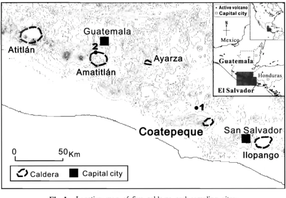
Coatepeque Caldera is one of five large calderas in the northern part of Central America and located 40 km southwest of San Salvador City, the capital of the Republic of EI Salvador (fig. 1). Ten million residents in the western pali of El Salvador, the southern part of Guatemala, and their neighboring areas are exposed to remarkable risk by eruption, because prevailing winds in the area tend to carry volcanic ash to the west.
Three tephras have been already described in previous works, and another tephra younger than the three was suggested. Their distributions in El Salvador have also been illustrated.
The fourth eruption, however, has not been supported with petrological and geochemical -::on-::olm;:pQ
and the distribution of the four outside of El Salvador remains unknown. This aims at presenting analytical data to support the existence of the fourth eruption of Coatepeque Caldera and to illustrate the distribution of the tephras in Guatemala City for more than 150 km away from the volcano to the northwest.
2. Previous works
;oatepeque Caldera (Lat. 13.87N, Long. Newhall & Dzurisin, 1958) is a caldera volcano (11.5 x 6.5 km). The inside of the caldera is filled with water and the altitude of the surface of the lake is ca. 750 m above sea level. The top of the caldera rim lies about 300 m higher than the lake level, and the caldera rim is lower on the northeast side. Santa Ana - Izalco volcanic complex is located to the west of Coatepeque Caldera. The doubly elliptical landform of the caldera enables us to assume several gigantic eruptions in the past. Three pumice-flow deposits and associated pumice-fall deposits have been described as Bellavista, Arce and Congo, from the older to the younger (CEL, 1992; Pullinger, 1998). Although the Bellavista tephra is restricted to the area nearest the the latter two tephras are h .. rv,rll" dispersed. The depositional dates of
8
iJLmJ~AA;*'·~ntit;t!i\fl~~fffili}f~*c~
m
6 .ij-(2006:q:.)"< ' ~ ,,)/« i ' ~ , _< "j? , ::~~:{~~'"
~~'';:\ ':I/O:'
,t'I';,,") GU!:Iternal!:l >:'I):\'-;-;". _"i','A"~ ':' . J
'.':;;;;-.... 11
1.:,'\[\; '; -I':'~ , ,~ ~/J"
',(;" . ':.: 'I;' I, (J \, I~'k:;;~~;~:' : *" Y 2;' ;:'';: :~!
,1 I.~ .'~i"
1.,,:' ,I ,)I"j!
•" ::i) \ .,,;::.':~:;';:~,;.~~ < J "~ . '. ·'.'( .. ;/
,.. - '-;,.i~.I.i}'
(1::
.., :" .~
•... '. ":\.I:
_.",'." I:.r ~'1
I'.i"
o,~;
Atltlan " ""-, " " •
,0 " ,S ,;" o.')'joOOAyarza ". '" ..
, J c ~ ;, I"" i\i;?' San Salvador
Coatepequ~. ," .;; .... , . . "') l~C ;ill:~/ "
'. , '7 'I<~-:;.~1~
. .
~) ,,~~.l ~~:;,
~ ";::' ··t'~~~i:,,·:
,-1,,-:J:·:-~ l'i' op ~.
angop"\ .y . .
o
50Km " .. ,c)
CalderaII
Capital cityI
Fig. 1 Location map of five calderas and sampling sites.
the Bellavista, the Arce and the Congo tephras are determined to be 77 ka, 72 ka and 56.9 ka, respectively, by highly precise 4°Ar/19Ar and highly sensitive l1C dating methods (Rose, et al., 1999).
Another pumice-fall deposit. above the Congo tephra, called Atiquizaya, has recently been reported and suggested to be derived from Coatepeque Caldera (Kitamura, 2006). The Atiquizaya pumice-fall deposit is not presumed to be much younger than the Congo pumice because of their close stratigraphic positions, although its radiometric age remains uncertain.
Three tephras except the Bellavista tephra are presumably distributed in the territory of the Republic of Guatemala over the border. In the area around Guatemala City, 150 km far from Coatepeque Caldera, two distinct volcanic ash-fall deposits are commonly observed. The underlying tephra has been called the A 1 tephra and the overlying one, the A2 tephra. They are intercalated among the brown volcanic ash soils deposited between two pumice-fall deposits, which are the C tephra, in the lower, and the E tephra, in the upper. Although the two volcanic ash layers have been described since Koch and McLean (1975), their origins and depositional dates remain uncertain.
Bot.h of them are finely grained white vitric ash, and their features are suggestive to be distal facies of pumice-fall deposits produced by gigantic eruption of caldera. They are younger than 84 ka and older than 24 ka because of the depositional dates of the underlying H tephra and the overlying B tephra.
3. Sampling sites
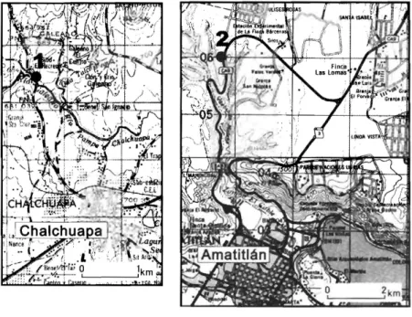
Around the Chalchuapa City located 10 km northwest of Coatepeque Caldera, the Arce, the Congo and the Atiquizaya tcphras are commonly observed. The samples of their tephras are obtained at an exposure located 5 km northeast of Chalchuapa City, El Salvador (location 1 shown in figs.
9 ...
A preliminary report of the tephrochronological study of the eruptive history of Coatepeque Caldera, El Salvador, Central Amelica
Fig. 2 Location of sampling site.
Solid circle on each map shows the location of sampling site, and number associated with the solid circle corresponds to the location number in fig. I and the column number in fig. 3. The left map contains two topographic maps on a scale of 1 :25,000, "Cha1chuapa" and "EI Provenir", published by the lnstituto Geografico Nacional de EI Salvador, and the right contains two topographic maps on a scale of 1 :50,000, "Ciudad de Guatemala" and "Amatitlan" published by Instituto Geografico Nacional de Guatemala.
I and 2). At this site, the Arce tephra is thickly bedded coarse pumice which intercalates a distinct vitric ash layer. The Congo tephra is stratified white coarse pumice and ash, or poorly sorted pumiceous ash layer where it has been disturbed. The Atiquizaya tephra is a massive layer consisting of white coarse pumice and underlain by a thinly bedded pinkish fine ash, probablY originating from another volcano far from Chalchuapa City (fig. 3).
The Al and the A2 tephras are commonly observed in Guatemala City and the surrounding area, as mentioned above, and sampled at another exposure located 3.5 km north of Amatitlan City, Guatemala (location 2 shown in figs. 1 and 2). At this site, both of them are thinly bedded vitric ash-fall deposits. The Al tephra is deposited above a coarse yellowish white pumice called the C tephra while brown volcanic ash soil is intercalated between them. The A2 tephra is underlain by brown volcanic ash soil and several scoria layers, which are probably ejected from Agua Volcano, above the Al tephra. Above the A2 tephra, brown volcanic ash soil and several scoria layers are observed overlain by another coarse yellowish white pumice called the E tephra (fig. 3).
4. Results of analyses
Volcanic glass and minerals were isolated from vitric ash or crushed pumice by supersonic washing and sieving. Mineral assemblage was illustrated by microscopic observation. Chemical composition of volcanic glass was analyzed quantitatively with a wave-length-dispersive electron
- 10-
51.lltr$~*$f±~tjjjtJ.I:$$li}f~M~
m
6 {} (2006~)1
o m
Chalchuapa
2
Legend
Vitric ash
[ill] Pumice
• Scoria
Atiquizaya Congo
Arce
• Volcanic sand
i l
Volcanic ash soilQ) (?)
CD
2
Amatitlan
E
A2
A1
c
vvvvvvvv vvvvvvvv vvvvvvvv vvvvvvvv vvvvvvvv vvvvvvvv vvvvvvvv vvvvvvvv vvvvvvvv vvvvvvvv vvvvvvvv vvvvvvvv vvvvvvvv
"".,,-@
vvvvvvvv vvvvvvvv vvvvvvvv vvvvvvvv vvvvvvvv vvvvvvvv vvvvvvvv vvvvvvvv vvvvvvvv vvvvvvvv
Fig.3 Tephra stratigraphy at sampling sites The sampling level is shown by the number with circle at the right of columns. The number above column corresponds to the location number in fig. I and fig. 2.
microprobe (lEOL JAX-8800RL) in the Department of Earth and Environmental Science, Hirosaki University. For analyses, 30 glass shards of each sample were randomly selected. Beam currents of 3 x 10⁻⁹ A and beam diameters of 10 L1 m were used at an accelerating voltage of 15 k V. Oxide percentage were renormalized to 100% and averaged with calculating standard deviation, after the removal of obvious anomalous results from the 30 analyses (table 1 and fig. 4).
The microscopic observation indicates that the Arce pumice contains biotite and hornblende, and the Congo pumice is rich in hornblende and orthpyroxene, containing a small amount of clinopyroxene. The Atiquizaya pumice contains hornblende and orthpyroxene, which is similar to the Congo pumice. It also illustrates that the Al ash contains biotite and hornblende, and that the A2 ash is rich in hornblende and orthpyroxene. These results are mostly coincident with the data reported in Koch and McLean (1975), Pullinger (1998) and Kitamura (2006).
Chemical compositions of all samples in this study are similar to one another in the characteristics of chemical composition (table 1 and fig. 4). The further detailed interpretation of the chemical data, however, suggests that they can be divided into two groups. The first group consists of the Arce pumice and the Al ash, while the second group consists of the Congo pumice, the Atiquizaya
11
A preliminary report of the tephrochronological study of the el1Jptive history of Coatepeque Caldera, EI Salvador, Central America
....-
cf2.
...
o
Ni=
....-
cf2.
...
C"?
o
N«
....-
~ o ...
o
Q)I.L
cf2.
...
o
c~
0.4
o o
o o
70
•
75
~',o
0.0"0 :L~ • • •
• •
O~
so
0.4 ...,...,....-r--r--T--r--r--r--r--r--r-"T"'"""'Ir--r-....,
....-
cf2.
...
o
0)~
a
•
~
o
o
, + " 5 * 7 " "65 70 75
so
2~~-r~~~-T-r~~~-r....,
....-
cf2.
...
01 CO ()
o o
a
• : . - . 0
o
V~o 0
o
'L-...L----L.--I-...&-.J...JL...I.----L.--L-..I.-.L-...IL...L--I... ...65 10
cf2.s
...
~
6~
4
70 75
so
• 0
•
:_0
aOo
r , t.65 70 75
so
650.4 r-i ~~r__r--.---.-~~~-r-r-....--.,..., 6 i
• a
so
o ~5
...
04
NCO
Z 3
o
<D
Areea <2> Congo
~ (3) Atiquizaya
• @ A1
• (5) A2 Fig.4 Harker diagram of ~::m~:d\T'u"rl
o
o
70
•
75
·:·°tiff- , .
0o • aal
• 0 tp
•
70 75
Si02(% )
samples
and the A2 ash. Si02 and K20 ratios of the first group are slightly higher and
so
80
and CaO are slightly lower than the second group. The ranges of
FeO and K20 of the first are larger than those of the second. While MgO of the first is depleted, the second contains a small amount of MgO.
5llliT"f:~k"f:ftft11'i\fll:"f:ffllijf'Je*2*
m
6 ~} (200611'-)Table 1 Chemical composition of analyzed samples
Location Sample
Tephra Si02 Ti02 AbO;, FeO MnO MgO CaO K20 Na20 Total Quntity
No. (%) (%) (%) (%) (%) (%) (%) (%) (%) (%) of analysis
CO Arce Average 74.8 0.1 13.1 1.4 0.1 0.0 0.7 5.7 4.1 100.0 27
1 Std.dev. 2.4 0.1 1.5 0.3 0.1 0.0 0.1 1.1 0.6
1 - - - - - - - - - - - - - - - - - - - - - -
(Chalchuapa) @ Congo Average 7iJ.0 0.1 13.7 1.8 0.1 0.2 1.1 iJ.7 4.2 100.0 26 Std.dev. 0.7 0.1 0.5 0.2 0.1 0.1 0.2 OA O.iJ
1 - - - - - - - - - - - - - -
@ Atiquizaya Average 74.0 0.1 13.8 1.8 0.1 0.2 1.1 4.6 4.3 100.0 23 Std.dev. 1.2 0.1 0.7 0.2 0.1 0.1 0.2 0.2 OA
r- - - - - - --- 1-- - -1 - - - -
@ Al Average 7iJ.3 0.0 13.7 1.3 0.1 0.0 0.7 5.6 iJ.3 100.0 26
2 Std.dev. 2.4 0.0 1.5 0.3 0.1 0.0 0.2 0.9 0.4
f - - - - --- - _ . _ - - - --- -- ---"~ - ---~."---.- ---
(Amatitlan)
® A2 Average 73.5 0.1 14.1 1.8 0.1 0.2 1.2 4.7 4.2 100.0 25 Std.dev. 0.7 0.1 0.5 0.2 0.1 0.0 0.1 0.2 0.4
5. Conclusion and perspective
Chemical analyses in this study suggest that the Atiquizaya tephra is quite similar to the Congo tephra, and is assumed to originate from Coatepeque Caldera.
Mineral assemblage and chemical composition illustrated in this study indicate that the Al tephra should be correlative to the Arce tephra because of their similarity. On the other hand, the A2 tephra should be correlative to either of the Congo pumice-fall deposit or the Atiquizaya pumice-fall deposit. Accordingly, the Al and the A2 tephras are assumed to be distal ashes dispersed broadly for more than 150 km by the gigantic eruptions of Coatepeque Caldera in the past.
In order to confirm them, further investigation and analysis of pumice-flow deposits corresponding to the Arce, the Congo and the Atiquizaya tephras are necessary. Further analyses of the Al and the A2 tephras in other locations are also available. It is most successful for correlation if the three tephras could be purchased in the field from the territory of El Salvador to Guatemala.
References
CEL (Comision Ejecuti va Hidroclectrica del Rio Lempa) (1992): Desarrollo de los recursos geotermicos del area Centro-Occidental de EI Salvador. Prefactibilidad geotermica del area de Coatepeque. Reconocimiento geotermico.
Informe final, Internal report.
Kitamura, S. (2006): Estudio estratigrafico de tcfra alrededor de sitio arqueologico de Chalchuapa, EI Salvador. In print.
Koch, A. J.. McLean, H. (1975): Pleistocene tephra and ash-flow deposits in the volcanic highlands of Guatemala.
Geo!. Soc. Am. Bul!., vo!.86, pp.529-5iJ 1.
Meyer-Abich, H. (1958): Active volcanoes of Guatemala and EI Salvador. In: Mooser, F., Meyer-Abich, H. and McBirney, A. R. (cds) Catalogue of the active volcanoes of the world including solfatara fields - Part IV, Central America -. IA VCEI, Napoli, pp.37 -105.
Newhall, C. G. and Dzurisin, D. (1988): Historical unrest at large calderas of the world: U. S. Geological Survey Bulletin 1855.
Pullinger, C. (1998): Evolution of the Santa Ana volcanic complex, EI Salvador. MS thesis, Michigan Technological University.
Rose, W. I., Conway, F. M., Pullinger, C. R., Deino, A., McIntosh, W. C. (1999): An improved age framework for late Quaternary silicic eruptions in northern Central America. Bul!. Volcano!., vo!.61 , pp.l06-120.
Simkin, T., Siebert, L., McClelland, L., Bridge, D., Newhall, C. and Latter, J. H. (1981): Volcanoes of the world.
Hutchinson Ross Pub. Co., Stroudsburg.
- 13-