133 Eds., A. Ishimatsu and H.-J. Lie, pp. 133–149.
© by TERRAPUB and Nagasaki University, 2010.
Environmental Settings and Harmful Algal Blooms in the Sea Area Adjacent to the Changjiang River Estuary
Mingjiang ZHOU
Institute of Oceanalogy, Chinese Academy of Science, 7 Nanhai Road, Qingdao, 266071, China
Abstract—The characteristics of the environmental settings of the sea area adjacent to the Changjiang River estuary include complex currents and water masses, the diluted water plume and its redirection, upwelling, front, and nutrients and their sources. The Changjiang River estuary characteristics also include the phytoplankton community, which can affect the growth, migration, assembling, resting and competition of algae to form red tides in this area.. The features of red tide events recorded in this area in terms of time, location and causative species were analyzed, and the main findings on the red tides during the recent cruises in this area are also introduced.
Keywords: the Changjiang River estuary, red tide, harmful algal bloom (HAB), environmental characteristics
1. INTRODUCTION
Under the joint effects of the huge water runoff (~9 300 × 108 m3·y–1) and sediment (~4.86 × 10⁸ t·y–1) from the Changjiang River (Chen et al., 2000), together with the complicated current system and the topography, the Changjiang River estuary and its adjacent sea area show many particular phenomena, including the diluted water plume and its redirection, coastal upwelling and fronts. The collective properties of the riverine input and regional oceanographic characteristics influence the unique water mass structure, the distribution of temperature and salinity, and the distribution of nutrients, by which the growth of marine organisms are restricted or promoted. The unique environmental settings are the important basis for the formation of the famous
“Zhoushan Fishery”, and could also be a crucial reason for the frequently-occurring red tides in this region. Recently, red tides caused by Prorocentrum donghaiense, with an affected area over thousands of square kilometers, occurred continuously in the Changjiang River estuary and the adjacent sea area from late spring to early summer (Zhou et al., 2001). Therefore, to understand the ecological and oceanographic mechanisms for the large-scale red tides is of particular importance (http://
www.973.gov.cn/programme973/enviroment/200208200039.html).
To evaluate the ecological and oceanographic mechanisms driving the frequently- occurring red tides in this region, firstly, it is necessary to have a comprehensive understanding of the environmental characteristics that may have a close relationship
with the red tides in this area. These include the currents, water masses, diluted water plume and its redirection, upwelling, fronts, nutrient variation, and the structure of the plankton community, which could affect the growth, migration, assembling, resting and competition of red tide causative species. Secondly, a review of the historical records of red tide incidents in this region should be made to elucidate the spatial, temporal and species compositional patterns of the red tides, as well as their relationships with the aforementioned environmental characteristics. Then, from the primary data obtained, targeted field and laboratory researches should be organized to study the basic ecological and oceanographic characteristics in the red tide regions to probe into the mechanisms and patterns of red tides.
A brief summary of the environmental characteristics of the sea area adjacent to the Changjiang River estuary, and historical records of red tide events are provided.
The preliminary results from the cruises carried out in 2002 by the CEOHAB project,
‘’Ecology and Oceanography of Harmful Algal Blooms in China’’ (Zhou and Zhu, 2006) in the red tides frequently-occurring region, are also introduced. The term “red tide” was used here since the “red tide” and “HAB (Harmful Algal Blooms)”, which was suggested to describe the harmful ecological phenomena in the ocean caused by the proliferation of algae or other tiny organisms (GEOHAB, 2001), could not be discriminated in the historical records of red tides in China. However, in the future, red tide monitoring and research in China would be better served by the adoption of the more scientific term of HAB.
2. ENVIRONMENTAL CHARACTERISTICS OF THE RED TIDE REGION IN THE CHANGJIANG RIVER ESTUARY AND
ITS ADJACENT COASTAL WATERS 2.1. Currents and water masses
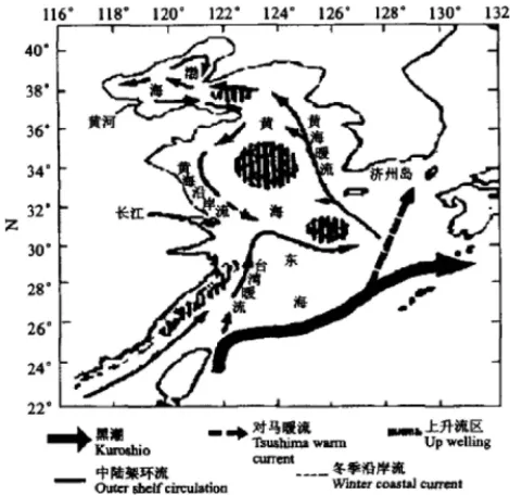
The red tide region in the sea area adjacent to the Changjiang River estuary is directly affected by the diluted water plume from the Changjiang River and the Taiwan Warm Current (TWC). Coastal currents of Subei and Minzhe, the Yellow Sea cold water mass and Kuroshio also indirectly affect the Changjiang River estuary (Fig. 1). The huge discharge of the Changjiang River forms a remarkable diluted water plume. In “winter” (from November to April), the diluted water mainly flows southeastwards. During the “summer” (from May to October), however, the direction of the diluted water changes from southeastward to northeastward from the area between 122°10′ and 122°30′ E (Zhang and Dong, 1993). The TWC flows northwards along the coast of Fujiang province and Zhejiang province. A branch of TWC can flow across the runoff of the Changjiang River at the bottom and extend to the area from the Changjiang River estuary to latitude 34°N. However, the mainstream of the TWC turns to the East China Sea and flows northeastward parallel with Kuroshio, and becomes a major source of the Tsushima Warm Current (Li and Ahao, 2001).
Kuroshio also affects this region through the TWC. The coastal currents of Subei and Minzhe, together with the cold water mass of Yellow Sea, may affect the redirection of the diluted water plume in spring and summer (Zhang et al., 1993; Zhu et al., 1997, 1998; Lioa et al., 2001). The plume fronts and convergent zones appear at the
interface between the diluted water plume and the TWC, which offer optimal conditions for the growth of algae, such as abundant nutrients, sufficient illumination and appropriate temperature. High density of algal cells is confined by the convergent zone to easily form a red tide.
2.2. Diluted water plume and its redirection
The Changjiang River is the largest river in China and the third largest in the world. About a trillion cubic meters of freshwater is discharged into the sea area adjacent to the Changjiang River estuary every year. The huge runoff from the Changjiang River brings not only abundant nutrients, which favor the growth of red tide algae, but also large amounts of sediments, which could inhibit the photosynthesis of the algae through reduced illumination. Therefore, any change in the region affected by the diluted water can affect the distribution of red tides.
Mao et al. (1964) first reported the redirection of the diluted water plume from the Changjiang River, which was considered as a unique character of the currents in China seas by Su (2001). According to the published references by Mao (1964) and Su (2001), the diluted water plume extends southeastwards to the Hangzhou bay and Zhoushan archipelago in winter (from November to April). However, during the summer time (from May to October), the diluted water will turn to the northeast in the sea area between longitude 122°10′ E and 122°30′ E (Zhao, 1991). Normally, the redirection of the diluted water will be completed in less than a week (Le, 1986). It
Fig. 1. Currents in the sea area adjacent to the estuary of the Changjiang River (after Hu 2001).
should be noted that the stage from April in “winter” to May in “summer” is critical for the massive proliferation of red tide algae. Therefore, whether there is an interrelation between the redirection of the diluted water and the large scale red tide in this region is worth studying.
The mechanism for the redirection of the diluted water has attracted attention from many physical oceanographers, but there is no uniform answer to this so far.
Zhao (1991) indicated that the redirection is not only related to the scale of the runoff from the Changjiang River, but also to the slope of sea surface and wind stress vorticity. Zhang et al. (1993) analyzed the effects of the topography of the seabed and coastal currents on the redirection. In a series of publications concerning the diluted water from the Changjiang River, Zhu and Shen (1997) systematically reviewed the progress made in this field, and put forward their opinion through a three-dimensional non-linear baroclinic shallow-sea and shelf model under the δ coordinate system. He found that besides the traditional diluted water observed, which firstly flowed southeastwards and then turned northeastwards, there was another branch of diluted water, which firstly flowed northeastwards, then turned eastwards and southeastwards and finally northeastward. The redirection observed was a result of two parts of diluted water. The principle reasons for the redirection being the wind and the Yellow Sea cold eddy (Zhu et al., 1997). Recently, Liao et al. (2001) insisted that the coupling of the Subei coastal current flowing southward in early summer and Zhedong coastal current (including the TWC) flowing northward and northeastward could be one of the most important external forcing for the redirection of the diluted water. More research on the mechanism of redirection is clearly needed.
2.3. Upwelling
Upwelling can continuously supply nutrients to the surface seawater, which makes an upwelling area a highly productive region in the sea (Zhao, 1991; Lu et al., 1997). Mao (1964) predicted the existence of upwelling along the coast of Zhejiang province early in 1964, which was confirmed later by the following research and investigations. At present, two obvious upwelling areas have been found in the sea area adjacent to the Changjiang River estuary. Cao et al. (1986) and Xu (1986) indicated that an upwelling area existed all the year round in the sea area at latitude 29°00′ N and longitude 122°30′ E. Zhao (1993) indicated another obvious upwelling area at 31°00′–32°00′ N, and 122°20′–123°00′ E, where the seawater came from the modified high-saline TWC water. The position of this upwelling area is in accordance with the distribution of a high production zone of phytoplankton outside the Changjiang River estuary. The upwelling phenomenon in the sea area adjacent to the Changjiang River estuary was also indicated through numerical simulation by Wang (1995, 1996).
Many hypotheses have been put forward for the potential driving force of the upwelling, such as wind, seabed topography, and the TWC (Hu, 1980; Pang, 1985;
Ding 2001). Liu and Su (1991) claimed that the wind stress was very important for the formation of upwelling and fronts in the inshore area along the coast of Zhejiang
province, while in the offshore area, the upwelling was mainly induced by the TWC flowing northward along the coast. Yan (1991, 1992) considered that the upwelling along the coast of Zhejiang Province was a joint effect of the currents and the landform. For the maximum flow rate of the upwelling, the estimated values ranged from 8.4 × 10⁻⁴ (Yan, 1992), 1.0 × 10⁻³ (Zhao, 1991) , 6.5 × 10⁻³ (Luo, 1998), 7.0 × 10⁻³ cm·s–1 (Liu and Su, 1991) to 8.9 × 10⁻³ cm·s–1 (Wang, 1996), and the difference was about one order of magnitude.
Through numerical simulation, Luo and Yu (1998) discussed the origin of seawater in the upwelling area in the sea area adjacent to the Changjiang River estuary. He found that seawater at the depth of 10 m in the coast of Zhoushan originated from the seawater at the depth of 25 m in the north entrance of the Taiwan channel 4 months ago, and seawater at the depth of 30 m in the coast of Zhoushan originated from the seawater at the depth of 68 m in the north entrance of the Taiwan channel 3 months ago. It can be seen that the TWC has a crucial impact on the sea area adjacent to the Changjiang River estuary. This result also suggests a potential source for the causative species of large-scale red tides in the sea area adjacent to the Changjiang River estuary.
2.4. Front
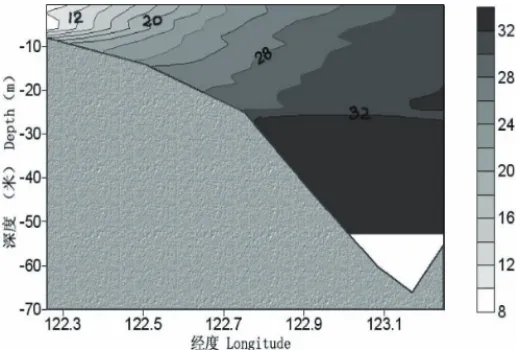
In the sea area adjacent to the Changjiang River estuary, high salinity seawater on the shelf pushes westwards at the bottom, and the diluted water plume from the Changjiang River moves outwards to the east on the surface, which leads to the formation of a plume front in the sea area near 123°E. Water of different quality from either side moves and mixes, and the convergent zone appears at the location of the front where the maximum salinity gradient exists (Fig. 2). The turbidity of seawater in this sea area decreases dramatically, but the nutrient concentration is still very high.
If the temperature, light and other environmental factors are appropriate, the red tide algae from the local water or transported from other sea areas can grow and form red tides under the convergent effect of the front. Therefore, the relationship between the front and the distribution of red tides is also an area that requires further study.
The location of the front can change with the discharge of the Changjiang River.
Based on the analysis of multiple-year satellite data and surveyed documents of temperature and salinity in the sea area adjacent to the Changjiang River estuary, Cao and Zhang (1993) found out that the location of the front was about 90 km away from the shoreline on average, with a swing amplitude about 40 km. A formula on the location of the front and flow of the Changjiang River is given below (Cao and Zhang 1993). The formula is useful for estimating the position of the front and predicting the possible distribution of large scale red tides.
S=45 51. Q Q+44 4.
Where S stands for the location of the front (the distance away from the shoreline, km), Q stands for the flux of the Changjiang River at Datong station (m3·s–1), and Q stands for the average flux of the Changjiang River (2.93 × 10⁴ m3·s–1).
2.5. Nutrients and their sources
High frequencies of red tides in the sea area adjacent to the Changjiang River estuary are closely related to the high concentrations of nutrients in seawater. The Changjiang River estuary is the most eutrophic water in the China seas. According to the China Marine Environmental Quality Bulletin (State Oceanic Administration, 2002), seawater in this area is moderately or seriously polluted, and the major pollutants are nutrients. There are a lot of reports about the nutrient concentrations and their variation in this region (Shen, 1991; Lu et al., 1996; Ye et al., 2000) , but little information is available on the input and sources of nutrients. It is generally accepted that the nutrients in this region mainly come from the discharge of the Changjiang River and the TWC. Nitrate and silicate in seawater mainly come from the discharge of the Changjiang River, since their distribution in the sea area adjacent to the Changjiang River estuary are negatively related to salinity (Shen, 1991; Wang et al., 1983, 2002). However, the sources of phosphate in this region are different from nitrate and silicate, and the contribution of the TWC for phosphate input into this region cannot be ignored. According to the previous investigations, the inorganic nitrogen transported to the East China Sea by the TWC was almost equivalent to the input from the Changjiang River, but the phosphate transported by TWC was 8–17 times higher than the Changjiang River (Chung et al., 2001). In autumn, the concentration of phosphate in the East China Sea might be controlled by the diluted water of the Changjiang River, biological activities and the TWC together (Hunag and Ji, 1994) , but in spring, the phosphate is mainly from the TWC (Chung et al., 2001)
Only a few data are available on the input flux of nutrients from the Changjiang River into this region, which was estimated by multiplying the Changjiang River runoff by the concentration of nutrients in the entrance where the salinity is zero, to roughly get the nutrient input flux into the sea. With this method, Wang et al. (1983), Shen (1991), and Shen et al. (1991) estimated the input flux of nutrients from the Changjiang River (Table 1). Meanwhile, Shen (1991) indicated that the relationship
Fig. 2. Plume front and convergent zone in the sea area adjacent to the estuary of Changjiang River (after Chen et al., 2001).
between the input of inorganic nitrogen (F, kg·s–1) and the runoff of the Changjiang River (Q, m3·s–1) could be described with the following formula:
F = 4.899 e–0.0000518Q (r = 0.929, n = 10)
Due to the fact the increased runoff of the Changjiang River resulted from the huge flood in 1998, Shen (2000) estimated that the input flux of inorganic nitrogen from the Changjiang River into the sea in 1998 was about two times that in ordinary years. Recently, Fu and Shen (2002) estimated the nutrient flux of the Changjiang River with a more comprehensive monitoring data (Table 1). In Table 1, it can be seen that there are dramatic differences among data of nutrient flux from those authors.
This could be a result of the different date and methods employed in their studies.
Therefore, in research of the relationship between the eutrophication and the red tides, the “real” nutrient flux of the Changjiang River needs a more comprehensive study.
As for the nutrient input flux from the TWC, no really good data could be cited here.
The nutrients from the dry or wet precipitation, biological activities, and those released from the sediment also need to be studied further.
To compare with each other, the monthly fluxes estimated in the references of Shen (1991) and Wang et al. (1983) were multiplied by 12 to obtain yearly fluxes.
2.6. Plankton community and succession
Documents relating to multiple-year investigations on phytoplankton net samples collected in the sea area adjacent to the Changjiang River estuary have been analyzed.
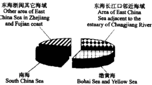
The documents show that the phytoplankton community in the red tide region belongs to the low-salinity phytoplankton community in the Changjiang River estuary and Zhejiang coast characterized by the wide-temperature and low-salinity adaptation.
Meanwhile, it also forms ecotones or community cross-zones with a low-salinity phytoplankton community in Subei coastal water, a high-salinity phytoplankton community in the central Yellow Sea, and a high-salinity and high-temperature phytoplankton community in the outside East China Sea (Fig. 3). Chen et al. (2001) and Wang et al. (1993) have reported that the species composition and population dynamics in the phytoplankton community changed dramatically under the joint effects of the Subei coastal current, the diluted water plume, the Yellow Sea cold
Table 1. Estimation of the nutrient flux of the Changjiang River.
Year Average flux (kg·s–1) Yearly flux (104 t) Referemce
1922–1985 0.48 21.90 1.51 69.1 [31]
1980.6 2.37 161.3 [44]
1985.8–1986.7 0.43 20.0 1.36 63.6 [32]
1997.12–1998.11 131.0 [31]
1998.2–1998.9 1.09/2.54 69.54/349.4 4.16 497.1 [7]
water mass and the TWC, which offered a good opportunity for the accumulation and proliferation of the red tide species. For example, the cell density of the red tide causative species Skeletonema costatum, which inhabits the small area adjacent to the Changjiang River estuary, can reach 108 cells·m–3 and accounts for 95–99% of the total biomass of phytoplankton from June to July under the effect of the strong diluted water of the Changjiang River. The distribution pattern of S. costatum red tide is associated with the dynamics of the diluted water plume of the Changjiang River (Guo and Yang 1982; Wang et al., 1993). S. costatum and Noctiluca scintillans may predominant alternately lead to red tides in this region, however, the mechanism for phytoplankton community succession is not clear. Whether phytoplankton community succession is driven by interogenous forcing (i.e. driven by biological processes inside phytoplankton community) or heterogenous forcing (i.e. driven by hydrodynamic factors, chemical factors and anthropogenic pollution etc.) is still uncertain. If the succession of phytoplankton community is more heterogenous than interogenous, the structure and function of the phytoplankton community would be affected by extreme forcing from outside, and the local ecosystem might collapsed under extreme conditions.
Fig. 3. Biogeography of phytoplankton community in the southern Yellow Sea and the western East China Sea. 1, Winter border; 2, Summer border; I, Low-salinity community in Subei coastal water;
II, High-salinity community in central Yellow Sea; III, Low-salinity community in Changjiang River estuary and Zhejiang coast; IV, High-salinity and high-temperature community in the outside East China Sea; V, Community cross-zone (Zhou et al., 2003).
Like other eutrophic waters, the red tide region in the sea area adjacent to the Changjiang River estuary, which include cross-zones of phytoplankton community, show edge effects of diversified species composition and high population density of certain species. At the initial stage of the community succession, the dominant species of the phytoplankton community grow under optimal conditions, due to abundantly available nutrients in the seawater. At the middle stage of succession, when the nutrient concentration decreases, algal diversity increases, but the cell density of most of the algae declines rapidly. At the late stage, most of the nutrients are depleted as nutrients assimilated by the algae and would be brought into deep water under the euphotic zone. Therefore, both the species and biomass of the phytoplankton community decline. The mechanism of phytoplankton community succession is probably related to the adaptive strategies of different algae species and interspecific competition (Margalef, 1968). To understand the formation of ecotones and their roles in red tides is important for the elucidation of ecological mechanisms of large scale red tides and early-warning of the potential impacts.
The interspecific relationship between organisms living in the same plankton community is always an issue of concern for ecologists and environmental biologists, with predation being the most important interspecies relationship. Previous studies indicate that the grazing pressures of herbivorous zooplankton regulate algal population dynamics. Yang (1997) analyzed the food composition in the alimentary canal of Calanus sinicus and found that phytoplankton was predominant, accounting for 98.6% of the total weight of the food. Among the phytoplankton ingested, diatoms dominated and accounted for 94.6% of the total weight of food, suggesting that C. sinicus had obvious prey selectivity. Wang and Fan (1997) and Li et al. (2002) studied the ingestion rate and grazing pressure of natural communities of copepods of different sizes on phytoplankton. They indicated that the grazing impact of copepods on phytoplankton was very high, and large copepod communities had a much higher prey rate than meso-copepod communities. Large copepods made a major contribution to whole pelagic copepods in their preying on phytoplankton, which accounted for 84% of the total prey amount in spring, and 67% in autumn. Sun and Qi (1993) reported that, the feeding rate of copepod Acartia spinicanda on Prorocentrun micans increased with the increasing diet algal cell density, and the maximum feeding potential could reach 33000 cells·individual–1·day–1. This result suggested that the grazing impact of the pelagic copepods could have a significant effect on the dynamics of red tides. Recently, Sun (personal intercommunication) found that microzooplankton communities might play an important role in the dynamics of the red tides in the sea area adjacent to the Changjiang River estuary, based on feeding pressure studies using microzooplankton. To provide biological evidence to elucidate the ecology of the red tides, it is important to further study and understand the effects of the predominant pelagic copepods in spring and summer (Calanus sinicus and Labidocera euchaeth) and Mesodinium rubrum and Noctiluca scintillans on the dynamics of red tides (caused by Prorocentrun sp. and Alexandrium sp.).
3. RED TIDE EVENTS IN THE SEA AREA ADJACENT TO THE CHANGJIANG RIVER ESTUARY
3.1. Historical and seasonal pattern of red tides
The sea area adjacent to the Changjiang River estuary is one of the most important red tide regions in China (Fig. 4). About one quarter of the recorded red tide events occurred in this region (http://www.soa.gov.cn/chichao/index.html). Since this region only accounts for a small part of the China seas, the significance of red tides here becomes more protruding. However, there are no formal records of red tides in this region until the beginning of the 1980s. Red tides of N. scintillans were recorded in June and August, 1981 and in 1982, red tides of Trichodesmium sp., Noctiluca scintillans and Ceratium sp. were also reported. More and more red tide events have been recorded subsequently, and there were 12 events from 1981 to 1989, and 39 events from 1990 to 2001 (Jiang et al., 1992). The increased number of red tide records could reflect intensified monitoring activities; however, it is believed that the frequency of red tides in this region is increasing.
There is a clear seasonal pattern of red tides in this region (Fig. 5). The number of red tides recorded in May is the highest of the whole year, accounting for 60% of the total events. Most of the red tides appear in April and May when the season changes from “winter” to “summer”. Whether this phenomenon has a relationship with the redirection of the diluted water in April and May still requires further study.
After July, the frequency of red tides decreases, and no red tides are recorded after September.
3.2. Spatial distribution of red tides
The spatial distribution of red tides in this region show that most of the red tides are distributed along the area between 122°30′ and 123°00′ E, where there is a steep seabed, including the sea area around Huaniaoshan island outside the Changjiang River estuary and the sea area around the Zhoushan island (Fig. 6). The relationship
Fig. 4. Frequency of red tides in different regions of China (Zhou et al., 2003).
Fig. 5. Seasonal pattern of red tide events in the sea area adjacent to the Changjiang River estuary (Zhou et al., 2003).
Fig. 6. Distribution of red tides in the sea area adjacent to the estuary of Changjiang River (Zhou et al., 2003).
between the red tides in this region and the characteristics of seabed landform, and the related upwelling and front, needs to be studied carefully.
3.3. Causative species of red tides
Due to limited monitoring and statistical efforts, many records of red tides in this region do not list the causative species, which makes it difficult to analyze changes in causative species. The only thing clear is that the causative species in this region include N. scintillans, S. costatum, Prorocentrum triestinum and Prorocentrum dentatum (=Prorocentrum donghaiense, see below), Trichodesmium spp., Ceratium spp. and species in Cryptophyta. The remaining records only describe the color of seawater during the red tides or the scope of the red tides.
Recently, the continuous-occurring Prorocentrum red tides, which affect thousands of square kilometers, have attracted attention worldwide. It was generally accepted that the bloom was caused by a single species in Genus Prorocentrum sp.
A number of scientists considered the causative species as P. dentatum (Wang, 2002).
However, others claimed that this species was not the P. dentatum first named by German taxonomist Stein, and it should be assigned a new species name of P. donghainse (Lu and Goebel, 2001; Lu et al., 2005). An international seminar was held on this issue, and it was accepted that this species was obviously different from the P. dentatum described by Stein. However, this species could be the same species that caused large-scale red tides in Japan, Korea, and Turkey, which was identified as P. dentatum by many scientists overseas. Therefore, it is important to correctly identify species both in China and other areas.
4. PRIMARILY RESULTS ON FIELD INVESTIGATION IN THE RED TIDE FREQUENTLY-OCCURRING REGION
IN THE CRUISE OF CEOHAB 4.1. Location of the plume front
In the cruise carried out in 2002, it was found that the location of the plume front was between 122°30′ and 122°30′ E, and the direction of the front was from northwest to southeast (the corner with longitude was less than 20°). Both the horizontal and vertical salinity gradients were very strong in the frontal area. The maximum horizontal and vertical salinity gradients reached 3.6 km–1 and 2.5 km–1 respectively.
The front in section C (31°N) is shown in Fig. 7. The location of the front coincides well with the formula suggested by Cao and Zhang (1993) (Section 2.4).
4.2. Population dynamics of red tides
In the spring cruise of 2002, the red tide caused by P. donghaiense, which was re-occurred in this area for several years, was first found on the day of May 3 in the region between 122°30′–123°00′E. It developed in the sea area southeast of Zhoushan island, started from about 300 km2 then extended northward gradually to the sea area near the Zhongjieshan islands to reached about 1500 km2. The cell density could reach 107 cell·L–1 in the surface water with a water depth between 0–10 m. The red tide finally disappeared after 30 days (Fig. 8). The continuous occurrence of
P. donghaiense red tides in the last several years suggest that there might be a fixed habitat for P. donghaiense in the red tide frequently-occurring region or nearby, or the cells can arrive at the red tide region by transportation of currents and form red tides under optimal environmental conditions.
During the 2002 cruise, a large-scale bloom of Alexandrium catenella was also found with a maximum cell density of 105 cells·L–1. This was the first record of a large-scale toxic red tide in China (under publication). The preliminary analysis found that the cellular toxicity was about 8.6 pg STX eq·cell–1, which was comparable to other moderately toxic Alexandrium species. Fig. 9 is the photograph of A. catenella cells that caused the red tide. The simultaneous breakout of
Fig. 7. Front structure along 31_N found on the cruise in May, 2002 (Zhou et al., 2003).
Fig. 8. Variation of affected area of P. donghainse red tide in May, 2002 (Zhou et al., 2003).
Prorocentrum and Alexandrium red tides suggest that there might be no competition between the two red tide species, or the mechanisms for the two red tides are different.
For example the seed population of A. catenella red tides could come from the germination of cysts, which have been found in the sediment. However, no cysts of P. donghaiense have been observed so far, and the source of P. donghaiense still requires further study.
4.3. Relationship between red tides and environmental factors
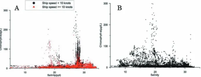
In Fig. 10, the relationship between chlorophyll-a (Chl.a) and salinity is illustrated. The figure presents the results from May (A) and August (B) of the 2002 voyage. It can be seen that the high values of Chl.a mainly appear in sea area with a
Fig. 9. A photograph of Alexandrium catenella (from Douding, L.U., unpublished).
Fig. 10. Relationship between Chl-a and salinity during the cruises in the sea area adjacent to the Changjiang River estuary (Chen, J.-C., unpublished). A: May cruise, B: August cruise.
specific salinity. In May the high values of Chl.a are mainly distributed in sea area with a salinity of 28, with only a small proportion in sea area with a salinity of 20. In contrast, in August, the high values of Chl.a are mainly distributed in sea area with a salinity of 20. According to the study carried out by Dr. Wang (personal communication), the optimal salinity for P. donghaiense, which forms red tides in May, is around 28 (when the water temperature was higher than 16°C). For S. costatum, which causes red tides in August, the optimal salinity ranges between 13–31, with the most optimal salinity between 20–30. This is in accordance with the field observations when the P. donghainense and S. costatum red tides were observed in May and August, respectively.
REFERENCES
Cao, X.-Z . 1986. Preliminary Study on the seasonal process of the coastal upwelling off Zhejiang in the East Sea. Journal of Fisheries of China 10: 51–69 (In Chinese).
Cao, X.-Z. and Y.-X. Zhang. 1993. Influence of Three-Gorge engineering on the environment of Changjiang River Estuary region. Donghai Marine Science 11: 17–22 (In Chinese).
Chen, Q.-C., Y.-Q. Chen and Y.-Z. Hu. 2001a. Preliminary study on the plankton communities in the southern Yellow Sea and the East China Sea. Acta Oceanologica Sinica 2: 149–157 (In Chinese).
Chen, S.-L., G.-C. Gu and F.-X. Hu. 2001b. The barrier effect of plume front on the submerged delta development of YangZe River Estuary. Marine Science 25: 55–56 (In Chinese).
Chen, Z.-Y., B.-P. Song, Z.-G. Wang and Y.-G. Cai. 2000. Late Quaternary evolution of the sub-aqueous Yangtze Delta, China: sedimentation, stratigraphy, palynology, and deformation. Marine Geology 162: 423–441.
Chung, S.-W., S. Jan and K.-K. Liu. 2001. Nutrient fluxes through the Taiwan Strait in Spring and Summer 1999, Journal of Oceanography 57: 47–53
Ding, Z.-X., 2001, Influence of wind on vertical structures of temperature and salinity, and upwelling off the Zhejiang coast. Oceanologia et Limnologia Sinica 14: 14–21 (In Chinese).
Fu, R.-B. and H.-T. Shen. 2002. The fluxes of dissolved inorganic nitrogen and phosphorus at freshwater end-member in the Changjiang Estuary. Acta Oceanologica Sinica 24: 34–42 (In Chinese).
GEOHAB. 2001. Global Ecology and Oceanography of Harmful Algal Blooms, Science Plan, P. Glibert and G. Pitcher (Eds). SCOR and IOC, Baltimore and Paris. 86 pp.
Guo, Y.-J. and Z.-Y. Yang. 1982. The ecological studies on the phytoplankton over the continental shelf of the East China Sea in the summer of 1976. Studia Marina Sinica 19: 11–32 (In Chinese).
http://www.973.gov.cn/programme973/enviroment/200208200039.html.
http://www.soa.gov.cn/chichao/index.html.
Hu, D.-X. 1980. Studies on Zhejiang coastal upwelling. Science Bulletin 3: 131–133 (In Chinese).
Hu, D.-X. 2001. Key Processes of Ocean Fluxes in East China Sea. Ocean Press, Beijing, pp. 3–13 (In Chinese).
Huang, Z.-Q. and W.-D. Ji. 1994. The characteristics of TP, OP and PO4-P and their interrelations in Changjiang Estuary. Acta Oceanologica Sinica 16: 51–60 (In Chinese).
Jiang, X.-S., J.-C. Hong, G.-L. Wang and X.-Q. Huang. 1992. Analysis of Noctiluca scintillans red tide occurred in red tide frequent area of Changjiang Estuary. Journal of Jinan University 13: 134–139 (In Chinese).
Le, K.-T. 1986. Some aspects of the path of the Changjiang diluted water. Studia Marina Sinica 27: 221–
228 (In Chinese).
Li, C.-L., R. Wang, F. Zhang and X.-G. Wang. 2002. A study on grazing of planktonic copepods in the Yellow Sea and East China Sea. Ingestion rate and grazing impact. Oceanologia et Limnologia Sinica Suppl. 111–119 (In Chinese).
Li, H.-F. and B.-R. Zhao. 2001. Numerical model of the circulation of the Bohai Sea and Yellow Sea and East China Sea. Marine Sciences 25: 28–32 (In Chinese).
Liao, Q.-Y., B.-H. Guo and Z.-P. Liu. 2001. Analysis of direction change mechanism of the Changjiang River diluted water in summer. Journal of Oceanography of Huanghai & Bohai 19: 19–25 (In Chinese).
Liu, X.-B. and J.-L. Su. 1991. Numerical model of the circulation of the Bohai Sea and Yellow Sea and East China Sea. Acta Oceanologica Sinica 13: 305–314 (In Chinese).
Lu, B.-W., R. Wang and W.-Q. Wang, 1997. Marine Science 5: 53–55 (In Chinese).
Lu, D. and J. Goebel. 2001. Five red tide species in genus Prorocentrum including the description of Prorocentrum donghaiense Lu sp. nov. from the East China Sea. Chinese Journal of Oceanography and Limnology 19: 337–344.
Lu, D., J. Goebel, Y. Qi, J. Zou, X. Han, Y. Gao and Y. Li. 2002. Prorocentrum donghaiense—a high biomass bloom-forming species in the East China Sea. IOC Newsletter on Toxic Algae and Algal Blooms. No. 23, 1–5.
Lu, D., J. Goebel, Y. Qi, J. Zou, X. Han, Y. Gao and Y. Li. 2005. Morphological and genetic study of Prorocentrum donghaiense Lu from the East China Sea, and comparison with some related Prorocentrum species. Harmful Algae 4: 493–505.
Lu, S.-Y., R.-F. Ge and L.-H. Liu. 1996. Seasonal variation and physical transportation of nutrients in the Ease China Sea shelf. Acta Oceanologica Sinica 18: 41–51 (In Chinese).
Luo, Y.-Y. 1998. Numerical modelling of upwelling in coastal area of the East China Sea. Transaction of Oceanology and Limnology 3: 1–6 (In Chinese).
Luo, Y.-Y. and G.-Y. Yu. 1998. Numerical studies of wind and TWC-driven upwelling in coastal areas of the East China Sea. Journal of Ocean University of Qingdao 28: 536–542 (In Chinese).
Mao, H.-L. 1964. Preliminary quantitative analyses of water mass in shallow sea using T-S correlation.
Oceanolocia et Limnologia Sinica 6: 1–23 (In Chinese).
Mao, H-L., Z.-J. Gan and S.-F. Lan. 1964. Preliminary study on the mixing and expansion of Changjiang River diluted water. Oceanolocia et Limnologia Sinica 5: 183–206 (In Chinese).
Margalef, R. 1968. Perspectives in Ecological Theory. Chicago: Chicago University Press. 111 pp.
Pan, Y.-Q., D.-R. Xu and J.-P. Xu. 1985. Front structure, change and its causes of Zhejiang coastal upwelling. Acta Oceanologica Sinica 7: 401–411 (In Chinese).
Shen, Z.-L. 1991. A study on the effects of the Three Gorge Project on the distributions and changes of the nutrients in the Changjiang River Estuary. Oceanolocia et Limnologia Sinica 22: 540–546 (In Chinese).
Shen, Z.-L. 2000. Studies on biogeochemistry of nitrogen in the Changjiang River and its estuary: output flux of nitrogen of the Estuary. Marine Sciences, inside back cover (In Chinese).
Shen, Z.-L., T.-X. Gu and X.-B. Xie. 1991. The output fluxes of biogenic element of Changjiang River Water. Marine Science 6: 67–69 (In Chinese).
State Oceanic Administration. 2002. Communiqué of Marine Environmental Quality of 2001 in China.
State Oceanic Administration, Beijing.
Su, J.-L. 2001. A review of circulation dynamics of the coastal oceans near China. Acta Oceanologica Sinica 23: 1–16 (In Chinese).
Sun, L. and S. Qi. 1993. The feeding rate of copepod. Acartia spinicauda on Prorocentrun micans.
Journal of Jinan University 14: 74–79 (In Chinese).
Wang, B-D., R. Zhan and J-Y. Zang. 2002. Distributions and transportation of nutrient in Changjiang River Estuary and its adjacent sea area. Acta Oceanologica Sinica 24(1): 53–-58 (In Chinese).
Wang, G.-L., X.-Q. Huang, X.-S. Jiang and J.-C. Hong. 1993. The distribution and characteristics of Skeletonema costatum red tides occurred Changjiang Estuary. Marine Science 51–55 (In Chinese).
Wang, H. 1995. Baroclinc model of winter circulation in the East China Sea and South Yellow Sea. Acta Oceanologica Sinica 17: 21–26 (In Chinese).
Wang, H. 1996. Baroclinc model of summer circulation in the East China Sea and South Yellow Sea.
Oceanolocia et Limnologia Sinica 27: 73–78 (In Chinese).
Wang, J.-H. 2002. HAB alga nearby Changjiang Estuary. Marine Environmental Science 21: 37–41 (In Chinese).
Wang, J.-H., W.-F. Wang and Z.-N. Wu. 2000. Phytoplankton communities in special area in East China Sea: Analysis of distribution in response to environmental factors. Acta Oceanologica Sinica 22(Suppl.): 286–291 (In Chinese).
Wang, R. and C.-L. Fan. 1997. Copepods feeding activities and its contribution to downwards vertical flux of carbon in the East China sea. Oceanolocia et Limnologia Sinica 28: 597–598 (In Chinese).
Wang, Z.-F., L.-K. Yao and X.-Z. Ruan. 1983. Distribution and characteristics of nutrients (N, P, Si) in the estuary of Changjiang River in June, 1980. Oceanolocia et Limnologia Sinica 14: 324–331 (In Chinese).
Xue, J.-P. 1986. Preliminary analysis of the hydrologic structure in the coastal upwelling area off Zhejiang in winter. Donghai Marine Science 4: 18–24 (In Chinese).
Yan, Y.-Z. 1991. Features and classification of coastal upwelling off China. Marine Science Bulletin 10:
1–6 (In Chinese).
Yan, Y.-Z., 1992. Analysis of the causes of upwelling formation off Zhejiang and East Hainan coasts.
Acta Oceanologica Sinica 14: 12–18 (In Chinese).
Yang, J.-M. 1997. Primary study on the feeding of the Bohai sea Calanus sinicus. Oceanolocia et Limnologia Sinica 28: 376–382 (In Chinese).
Ye, X.-S., Y. Zhang and Y.-T. Xiang. 2000. Characteristic of nitrate distribution in the Changjiang River Estuary and its cause of formation. Marine Science Bulletin 19: 89–92 (In Chinese).
Zhang, Q.-H. and C.-M. Dong. 1993. On the correlation of the diluted water of Yangtze River and ecological environment of its adjacent oceanic area. Journal of Oceanography of Huanghai & Boha 11: 27–29 (In Chinese)..
Zhang, Q.-H., F.-L. Qiao and Y.-M. Chen. 1993. Effects of seabed topography and coastal currents on the distribution of Changjiang River diluted water. Acta Oceanologica Sinica 15: 1–15 (In Chinese).
Zhao, B.-R. 1991. The mechanism of the direction change of Changjiang River diluted water. Acta Oceanologica Sinica 13: 601–610 (In Chinese).
Zao, B.-R. 1993. Upwelling outside of Changjiang Estuary. Acta Oceanologica Sinica 15: 108–114 (In Chinese).
Zhao, B.-R., G.-F. Ren and D.-M. Cao. 2001. Characteristics of the ecological environment on upwelling area adjacent to the Changjiang River Estuary. Oceanolocia et Limnologia Sinica 32: 327–333 (In Chinese).
Zhou, M.J. and M.Y. Zhu. 2006. Progress of the project "ecology and oceanography of harmful algal blooms in China". Advances in Earth Science 21: 673–679 (In Chinese).
Zhou, M-J., M.-Y. Zhu and J. Zhang. 2001. Status of harmful algal blooms and related research activities in China. Life Science 13: 54–59 (In Chinese).
Zhou, M.-J., T. Yan and J.-Z. Zou. 2003. Preliminary analysis of the characteristics of red tide areas in Changjiang River estuary and its adjacent sea. Chinese Journal of Applied Ecology 14: 1031–1038 Zhou, M.-J., Z.-L. Shena and R.-C. Yua. 2008. Responses of a coastal phytoplankton community to increased nutrient input from the Changjiang (Yangtze) river. Continental Shelf Research 28: 1483–
1489.
Zhu, J.-R. and H.-T. Shen. 1997. The mechanism of the expansion of the Changjiang (Yangtze River) diluted water. East China Normal University Press, Shanghai, pp. 10–177.
Zhu, J.-R., Y.-P. Li and H.-T. Shen. 1997a. Numerical simulation of the wind field’s impact on the expansion of the Changjiang River diluted water in summer. Oceanolocia et Limnologia Sinica 28:
72–79 (In Chinese).
Zhu, J.-R., H.-T. Shen and J. Zhou. 1997b. Numerical simulation of the impact of the Subei coastal current on the expansion of the Changjiang River diluted water in summer. Journal of the East China Normal University (Natural Science) 62–67 (In Chinese).
Zhu, J.-R., C.-Y. Xiao and H.-T. Shen. 1998. The impact of Yellow Sea cold water mass on the expansion of the Changjiang diluted water. Oceanolocia et Limnologia Sinica 29: 398–394 (In Chinese).
Zhu, S.-X., J.-R. Zhu and W.-Y. Sha. 1999. A numerical study on the impact of M2 Tide on the expansion of the Changjiang River diluted water in summer. Oceanolocia et Limnologia Sinica 30: 711–718 (In Chinese).
M. Zhou (e-mail: [email protected])