98
Copyright@SPSD Press from 2010, SPSD Press, Kanazawa
The Perception of Land Rights Impacts due to the Abolition of a Native Title (NT): Evidence from the Bakun Hydroelectric Project (BHP) and the Kelau Dam Project (KDP) in Malaysia
Nor- Hisham1*, Md- Saman1,2 and Peter, Ho3
1 Leiden Institute of Area Studies, Leiden University 2 University Teknologi MARA (Perak)
3 Leiden Institute of Area Studies, Leiden University
* Corresponding Author, Email: [email protected] Received 1 Feburary, 2014; Accepted 13 August, 2014
Key words: Indigenous People, Native Title, Institution and Credibility
Abstract: What is the best way in designing a credible institution? Can one be designed using a top approach through mass social engineering where rules mainly come from the top level? Or designed from the bottom level where the rules of the institution are taken from the local level? Do the socio-economic contexts of the local people need to be considered in designing policies? These are the main empirical and theoretical questions that this paper intends to answer. This paper is a study of the land rights impact on two Indigenous groups in Malaysia, namely the Orang Ulu and the Orang Asli. Both Indigenous groups have been affected by the Bakun Hydro Electric Project (BHP) in Sarawak and the Kelau Dam Project (KDP) in Pahang. By using land rights as a subject of exploration, this paper demonstrates how the development of resettlement schemes carried out in Malaysia have failed in giving credibility to the institution. In this research study, land rights impacts are part of the impacts caused by the development project which has involved Indigenous people who have strongly relied on land as a source of their livelihood. This research study has employed a mixed method study which involves various data generation instruments, namely survey, interview, observation as well as content analyses.
This research study has found that the negative impacts of the loss of land rights have altered the ways Indigenous people governed their land including how they own, use and enforce the land system. It was obvious that land rights are a fundamental feature in creating a credible institution in the context of Indigenous people in Malaysia. This paper hopes to illustrate the indigenous peoples’ perception on the loss of their land rights as well as to enrich the debates on the credibility of the institution.
1. INTRODUCTION
Together with the state laws, customary law is a system that has governed the Indigenous peoples’ lives in Malaysia, including land matters.
The Native Title (NT) has been proven to be a success in maintaining and managing their local social stability and ways of life. As a multi-ethnic country, Malaysia has practices in the legal system which recognise custom as one of the sources of the law system. It is clearly stipulated under Article 160(2) of the Federal Constitution (GOM, 2013). This is also clearly evident
through the establishment of the ‘syariah’ or Islamic court system as well as the native court (The native court established only for the Indigenous people in the states of Sabah and Sarawak). At the national level, albeit a Malaysian judicial recognition of the NT which has evidently been seen as an Indigenous victory (see a few leading cases, for example Sagong Tasi;
Adong bin Kuwau and Nor Ngawai (HRCM, 2009)), the reality paints a different picture. There is an increasing number of encroaching activities of land seizures by the state, as well as its corporations, into lands belonging to the Indigenous people. These cases have been reported in the local media (see protest by Indigenous people, Baram Dam, northern Sarawak, Malaysia by Stephen, T., (2014)). To these poor Indigenous people, the illegal encroachments, which have always been justified by the state in the name of development, appeared to have obtained the green light from the state authority. As such, it is difficult to deny the public perception that the government has deliberately been reluctant to accord the same legal tenure land rights to the Indigenous people as has been done for the Malay Reservation Land (MRL) (HRCM, 2010). However, such discussion is beyond the scope of this paper. Instead, this paper attempts to demonstrate how the Indigenous groups lose their land rights due to these two dam development projects where they have been forced to resettle under new resettlement schemes. In relation to this, for example, at the Resettlement Schemes of Batang Air in Sarawak and the Resettlement Schemes of the Semenyih Dam, the displaced Indigenous people have pointed out that the socio-economic impacts from the loss of their NT has consequently resulted in a deteriorating quality of Indigenous life itself (Ibrahim, 2010; Carol- Yong, 2008; HRCM, 2007; Banerjee, and Bojsen, 2005; Nicholas, 2000, 1997).
These entire scenarios have led to the issue of crafting a credible institution. The question is whether the state is able to design a credible institution through social engineering, such as through resettlement schemes where the customary institutions would be abolished and be replaced with a new institution in a land tenure system. To explore this issue, this paper is giving serious attention to the land rights impacts that have occurred due to the two development projects, namely the Bakun Hydroelectric Project (BHP) in Sarawak and the Kelau Dam Project (KDP), the Interstate Raw Water Transfer Project from Pahang to Selangor. Both projects have badly affected the Indigenous people of Malaysia namely the Orang Ulu in Sarawak and the Orang Asli of the Malay Peninsula. For the Orang Ulu, they have been resettled from their original settlements (villages) of Ulu Balui to the Resettlement Scheme of Sungai Asap, Bintulu Sarawak (RSSA).
Meanwhile, the Orang Asli have been moved out from Sungai Temir Village to the Resettlement Scheme of Lurah Bilut, Raub Pahang (RSLB).
Following the introduction, this paper is structured into three parts. The first part mainly touches on the concepts and terms used in this paper, namely institution, land rights, property rights and credibility. The second part introduces the concept of the statutory land rights in Malaysia, the Native Title and its outlook, as well as a brief discussion on the state’s position regarding the NT. The third section is the analysis the Indigenous peoples’ perception on the land rights impacts is discussed.
2. EXAMINING INSTITUTION, CREDIBILITY, LAND RIGHTS, PROPERTY RIGHTS AND NATIVE TITLE
In order to facilitate clear understanding, it is useful to provide some theoretical background on the main concepts applied in this paper. It is clear that there is no single term that can represent the definition of ‘institution’. It is a multifaceted term and the concept consequently varies between scholars.
However, in a simplified approach and as asserted by Ho (2005b),
‘institution’ can be defined in two different ways: 1) from the behavioural perspective, institution is the rules of the game in society. This definition has been employed by others, for example, Knight (1992) who has defined institution as a social set of rules that structure social interactions in a particular way. The same line of definition was given by North (1990) who has viewed institution as ‘the rules of the game in a society or, more formally, the humanly devised constraints that shape human interaction’, and;
2) on the flipside, Ho (2005a) has viewed ‘institution’ as the “legal and state administrative sphere or institutional arrangement which is embodied in promulgated policies, formal laws and customary rules well as the state administration”. For the context of this paper, the straight forward definition of ‘institution’ which is the ‘social rules’ is adopted here. As such this paper has regarded the societal and economic phenomena of land rights that have been affected by and at the same time are affecting the institution in Malaysia.
According to Knight (1992), institution is the human interaction agent’s decision and action of structures through formal and informal rules. Custom or ‘adat’ is part of the informal rules, therefore, custom in this regard is the set of rules which have regulated activities and maintained order and social relationships. In relation to land rights, custom would define the individual’s right to the land. It also dictates the law of inheritance and/or transferability of land from the pioneering ancestor to the present generation (Hong, 1987 ; Ngidang, 2005).
What is then the relation between land rights and institutional credibility?
The current debate on the institutional change has suggested that any institution designed must possess the element of acceptance or trust (the credibility) to the system as a key determinant of policy success. Only by having the credibility, the institution would bring about a positive effect as it intends to do. Therefore, establishing a credible institution means that it is able to rally social and political support for the project or policy. (Ho, 2006;
Ho, 2005a; Ho, 2005b). To put it in different words, the institution without credibility would lead to low credibility, or even a negative effect on the action of the social and political actors. Therefore, the institution must be seen to acquire credibility in order for the institution rules to be supported by the local and social actors.
As development projects require land, they inevitably involve the land rights issue. The United Nations (UN) – Habitat (2012) has defined land rights in four ways: 1) the allocation of rights in land; 2) the delimitation of boundaries of parcels for which the rights are allocated; 3) the transfer from one party to another through sale, lease, loan, gift or inheritance, and; 4) the adjudication of doubts and disputes regarding rights and parcel boundaries.
For simplicity, however, this paper regards land rights as rights to use, rights to control and rights to transfer.
Relating to the land rights concept, this paper takes the stand that the concept of land rights relates to the concept of property rights, where property rights itself involves rules (formal and informal) that designate the appropriate use, control and right to transfer (Knight, 1992). Other scholars, on the other hand, have suggested that property rights are a concept of rights and duties with settings and circumstances (including objects) capable of producing income. It is a social relations concept in the general sense (Ho, 2005a; Weimer, 1997). This paper follows the concept of property rights as advocated by Haber, S., Razo, A. and Maurer, N. (2003) who have provided two perspectives in approaching land rights issues: 1) firstly, from the holder’s view where it touches on three main rights: i) the rights to use an asset; ii) the rights to use the asset and to earn income and contract regarding the asset; iii) the rights to alienate, sell or transfer the asset, and 2) secondly, on the state’s view, the rights are related to two rights: i) to specify property rights and; ii) to enforce them.
Another term used in this paper is Native Title (NT). It is an umbrella term which covers the concept of the Native Customary Rights (NCR) over land for the Orang Ulu in Sarawak and Sabah. It also includes the Aboriginal Reserves/Areas for the Orang Asli in the Malay Peninsula. NCR is a term in Sarawak and Sabah which describes the interests of the natives in their traditional land. As asserted by HRCM (2009), the court in Malaysia has regarded both of these Indigenous peoples’ customary rights as synonymous.
Therefore, this paper refers to both customary titles as the NT. The NT is a generic term that relates to rights held by the Indigenous people of Malaysia on land which can be assessed on three broad aspects: 1) rights to own; 2) rights to use land, and; 3) rights to enforce and transfer. Besides conceptualising the NT in terms of ownership, this paper acknowledges that the NT also relates to the concept of the sovereignty of the indigenous people in managing and controlling its land and natural resources. This conceptualisation was actually in line with the self-determination principle as advocated by the United Nations ( 2007). For example, at the village level, the customary institution which governs the Orang Ulu affairs including regulating and monitoring land rights has comprised of the ‘Pemanchar’,
‘Penghulu’, ‘Tuai Rumah’ and the Elderly Council. Likewise the Batin, Ministers and the Custom Council on the Malay Peninsula can be in charge in the case for the Orang Asli. It is true that the powers of this traditional institution at the resettlement schemes have been diminished to some extent, if not totally abolished, through the introduction of the new administrative state structure, namely the Land and District Office, which consequently has changed the NT rights from the communal titles to the individual land titles.
However, such deeper enquiry on the sovereignty concept is beyond the intention of this paper.
3. STATUTORY LAND RIGHTS IN MALAYSIA
This section discusses the statutory land rights in Malaysia. It aims to demonstrate the institution of the NT and land rights as have been accorded to the Indigenous people prior to their resettlement. Only by having
discussion on the previous system, then will one be able to identify the reasons as to why Indigenous people were found to be dissatisfied with the new resettlement schemes.
As clearly stipulated in Article 160 in the Malaysian Federal constitution, it has asserted that law in Malaysia also constitutes ‘custom and usage having the force of law’. The Constitution also conferred to the state jurisdiction on custom (GOM, 2013). The position of custom over land in the Malaysian land laws and policies is further strengthened through the existence of Section 4 (1) of the National Land Code 1965 (NLC) which states that ‘if there’s a conflict between the NLC and any customary legislation, the customary provision prevails’ (GOM, 2010).
3.1 Native Title (NT)
Under the NT system, communal rights are inherited and retained by the Indigenous community and passed down to their future generations. The land rights also include the right to cultivate the cleared farming land. To those who have first cleared the land, they would have the priority with respect to the rights of the land. He/she may pass down the land to his/her heirs. However, as the name suggests, the NT cannot be transferred, leased, transmitted or sold outside to non-indigenous owners. The restriction is made based on the interpretation of the definition of ‘indigenous’ itself - be it the Orang Ulu or the Orang Asli where only Indigenous people who have been accorded by their community with the Indigenous status can have the right to acquire the NT (Fong, 2011). The reason behind it is to protect the land from falling to other ethnic groups (Buang, 2010; Fong, 2011). In addition, it also cannot be transferred from one category of land use to another, for example, from agricultural land use/activity to industrial use.
Since the NT is a communal title, the land technically falls under state land, unless the land has been surveyed and granted a title. In terms of value, the NT would get a lower value as compared to the individual land (Fong, 2011). In terms of the governance of the land, both these Indigenous groups have their own systems in governing the land. In Sarawak, the four aristocrat leaders (or Maren Uma) of the Orang Ulu are the ‘Temunggung’,
‘Pemanchar’, ‘Penghulu’ and ‘Tuai Rumah’ and the elderly/village council are involved in making any decisions regarding land matters. They are the entrusted parties to manage the NT land system at the longhouse level.
Meanwhile in the Malay Peninsula, the Batin (headman) and two of its Ministers, as well as the Customary Council, are responsible to govern land matters for the Orang Asli at the village level.
The chief tasks of the local Indigenous institution are monitoring and enforcing the rules on the using, controlling and transferring of the land rights within the communities. In addition, they also have the power to allocate land to individual households in the area and to settle disputes on land matters, for example on boundary claims. The power accorded to them is quite wide and powerful (interview with Penghulu Saging, at RSSA on 30 October 2012; interview with Pemanchar Umek at RSSA on 29 October 2012; interview with Cham, a Batin at RSLB on 24 November 2012). In the case of the Orang Ulu, if conflicts on the land rights have occurred, the disputants can bring their disputes to the native court. The native court operates from the village level to the district level (interview with Sindang,
an officer in the Customary Council of Sarawak (MAIS) on 9 November 2012). However, to the Orang Asli in the Malay Peninsula, even prior to the resettlement at the RSLB, there is no existence of the Orang Asli native court system whatsoever for them (Nicholas, 2010). The community has to depend on the civil court system to settle their land rights problems.
However, the power on land matters was found by researchers to still exist for the Batin and the Ministers during field works in 2012. Unfortunately, as previously mentioned, the local Indigenous peoples’ powers in managing their local affairs in order to maintain their communal forms of ownership, and their right to the use and enjoyment of their land have been diminished due to the relocation exercise and the setting up of new administrative institutions such as the District and Land office by the state. For example, the previous power conferred to the Tuai Rumah or Batin in managing land disputes at the village level, including the determination of the size, area and location have now been completely taken over by the District and Land Office.
3.2 The Orang Ulu Land Rights
This section briefly elaborates the state’s position on the NT of the Orang Ulu in Sarawak. According to HRCM (2009), the recognition of the NCR position in Sarawak can be traced to Section 2 of the Sarawak Land Code 1958 (SLC) which has defined the Native Customary Land (NCL) as:
‘Land in which native customary rights, whether communal or otherwise, has lawfully been created prior to the 1st day of January 1958 and still subsist as such.
It further details:
1. That it states a cut-off point by which a native has to prove the creation of NCR; i.e. before 1st January 1958. (If a native creates the NCR over land after 1958, the native must be provided with a permit under section 10, as provided for under Section 5 of the Code).
2. That the said NCR Land can be created and therefore claimed by a community or an individual.
3. That it subsists as such until today.
In principle, the SLC has stated that prior to 1958, the indigene must demonstrate to have carried out certain lawful methods of activities in order to establish the NCR, where Section 5(2) Part 11 states the following methods (HRCM, 2009):
1. The felling of virgin jungle and the occupation of the land thereby cleared;
2. The planting of land with fruit trees 3. The occupation or cultivation of land 4. The use of land for burial ground or shrine 5. The use of land of any class for rights of way 6. By any lawful method (which was deleted in 2000)
While some forms of recognition on the NCR are given by the state, it has, however, come with limitations as the above methods are only applicable in the interior areas and only if a permit was obtained under Section 10 from the Land and District Office. Anyone attempting to acquire
customary rights without permission is deemed to have unlawful occupation of the State land (Cramb, 2007). To further curtail land rights in Sarawak, it was done through the amendment of the Land Code (amendment) Bill 2000, when the Sarawak State Assembly on 9 May 2000 nullified the additional provision (Section 5(2)) which previously has included ‘any lawful methods’
as a way to establish a claim on the NCR’. This time this method was appealed by the state (HRCM, 2007).
Another hot dispute on the NCR relates to customary claims where Indigenous claims of their land rights go beyond the ’temuda‘. It includes their communal lands or territorial domain locally referred to as ’menua’ or
‘pemakai menua’ and the ’reserved virgin forests’ or ‘pulau galau/pulau’
or ’Tuan Long’ in the Orang Ulu terms. The Pulau is an area where a communal preserved or reserved area is specifically allocated to meet the domestic needs of the Indigenous people (BRIMAS, 2005). The community would enforce rules with respect to the collective rights of the ‘pulau’
consumer products such as rattan, timber, fruit trees and so on. According to Bian (2000), the unrecognised ‘temuda’ status also relates to the issue of compensation. This is because the time-frame definition adopted by the Sarawak Government is very narrow. It is only applicable as ’temuda’ when it has been cultivated or farmed before 1st January 1958.
3.3 The Orang Asli Land Rights
Like the Orang Ulu in Sarawak, the Pahang Orang Asli’s land category is divided into three categories, namely: 1) active/productive, where land is being cultivated; 2) inactive land (or ‘rang’ land), where land is temporarily left in order to make it regain its fertility; 3) Roaming/ foraging/game area, where products for communal use can be found such as medicine, rattan, herbs, wood and house materials. However, it is important to note that unlike the Orang Ulu, these land categories cannot be considered fully established by the Orang Asli themselves since the majority of them are now practicing cash crops (Interview with Yusri, a committee member of the Orang Asli Network Villages (JAKOSAM) cum deputy 3 of the Association of Orang Asli Peninsular Malaysia (JOAS) on 3 December 2012). In the Orang Asli’s ancestral territory there is the communal land where activities like hunting, fishing, gathering and cultivation are carried out. However, individual land rights exist where there are fruit trees and swidden which are cleared and are being used by individual members of the group (Hong, 1987).
It is a fact that the Indigenous customs in relation to land have been incorporated into the state law through the establishment of the Aboriginal Peoples Act 1953 (APA). The APA recognises the creation of the Orang Asli Reserve Area. It empowers the Federal Minister concerned to declare, through publication in the gazette, certain plots of land to be protected as the Indigenous reserves and areas. However, the glaring deficiency of the APA is that Section 8 (2) (c) does not treat the Orang Asli as the legal owners of the reserves, instead, the best recognition that could be obtained by the Orang Asli is the ‘tenant-at will’ (GOM, 1997; Hamid and Nor Ashikin, 2011). While Section 12 of the APA recognises that the compensation
‘shall’ and must be paid by the government for the acquisition of the Orang Asli’s crops. But the unfortunate fact is that Section 11 of the same Act, does not mandate government’s compensation for the acquisition of their reserves.
In terms of extinguishment, Sections 6 (3) and 7 (3) of the same Act allows
the Federal Minister to revoke the whole or part of the declaration of the Aboriginal area and the Aboriginal reserve.
The problem concerning land rights of the Orang Asli on the Malay Peninsula is also complicated by the issue of the federal-state relationship.
Since Malaysia is a Federation, Article 8 (5) (c) of the Federal Constitution has stipulated that the power and relationship between the federation and the state on land and the Orang Asli matters are under the federal jurisdiction which read as below:
“… for the protection, well-being or advancement of the aboriginal peoples of the Malay Peninsula (including the reservation of land) or the reservation to aborigines of a reasonable proportion of suitable positions in the public service” (GOM, 2010).
On the one hand, land matters in general are under the purview of the respective state which can then lead to serious implications for the Orang Asli’s land. Land matters have become bureaucratic and tend to involve a long process. In this sense, the constitutional shortfall has tied up their hands with regard to the land titling process (Interview with Abdul- Razak, A., an officer at the DOA on 9 July 2012; Nicholas, 2010). In addition, despite being a leading agency in the Orang Asli affairs, the Department of Orang Asli (DOA) has also been accused of being ineffective in preventing the territorial dispossession of the Orang Asli lands. As such, the current policies and laws are deemed as deliberate denials of the Orang Asli’s recognition of their rights (CAP, 2000).
4. RESEARCH METHODOLOGY IN SURVEY DATA COLLECTION
This research study adopts a mixed methods study through a variety of data generation instruments which include a survey of both the Orang Ulu at the RSSA, Sarawak and the Orang Asli at the RSLB, Pahang. Besides that, interviews were also carried out with the selected government officers, dam project developers and Non-Governmental Organisations (NGOs). To strengthen the analysis, participatory observations in both of the resettlement schemes as well as reviews of the existing policies and guidelines on the Indigenous people and land rights were also done.
This research study involved two groups: 1) two Indigenous groups, the Orang Ulu and the Orang Asli; 2) two projects in two different states/regions, the BDP in Sarawak and the KDP in Pahang, and; 3) two indigenous land policies, the SLC and APA. As asserted by Yin (2009) through two case studies, the researcher would be able to carry out a comparison study of similar results (literal replication) or contrasting result (a theoretical replication). However, the main intention of this research was that by using the multiple-case study, it would blunt any criticisms and scepticisms about the findings of this study. A multiple-case study also could produce an even stronger effect when compared to a single case study (Yin, 2009). In simple words, the two groupings would provide a solid reflection of the land rights battle in Malaysia. In this sense, this paper posits it would not be necessary to separate the analysis results based on the Indigenous groups because the
main intention of this research paper is to highlight the pattern of respondents’ perceptions on land rights in general.
In terms of field work, the first preliminary data collection for the BDP was done in May 2011. The survey first involved semi-structured interviews and participatory observations. Later, the second round of site visits was carried out from September until November 2012. This time, the questionnaire survey was carried out with 220 respondents from ten longhouses which comprised five different sub-groups, namely the Kenyah, Kayan, Lahanan, Ukit and Penan of Sarawak. Prior to that, to test the validity of the research questionnaire, a pilot survey on 15 households of the RSSA in Sarawak was carried out, a week before the actual survey.
In view of the fact that the KDP is located in Raub Pahang, which is situated near to Kuala Lumpur, preliminary site visits to the KDP had been done three times between May 2011 and July 2012. The pilot survey on seven households had also been commenced before the final questionnaire survey of 37 respondents of the Orang Asli was done. The actual survey and interviews were carried out in the second and third weeks of November 2012.
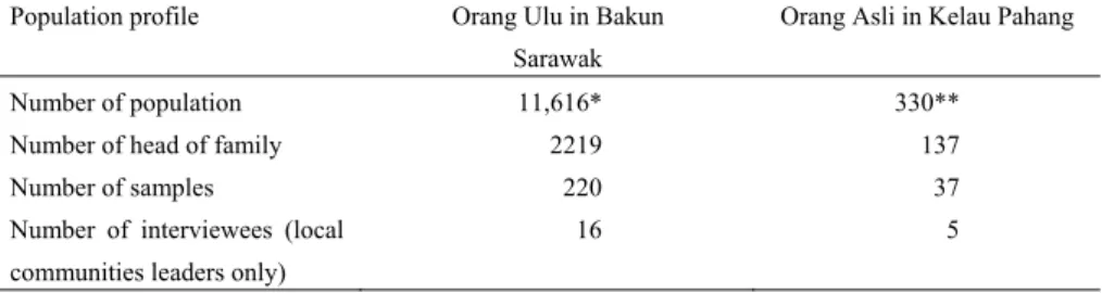
Table 1 below shows the population and sampling profile in both the resettlement schemes.
Table 1. Population and sampling profile in both the resettlement schemes
Population profile Orang Ulu in Bakun
Sarawak
Orang Asli in Kelau Pahang
Number of population 11,616* 330**
Number of head of family 2219 137
Number of samples 220 37
Number of interviewees (local communities leaders only)
16 5
Sources: *Sub-District of Sungai Asap, 2011; **DOS, 2011.
As shown in Table 1, the total population of the Indigenous residents of the Orang Ulu in the RSSA was 11,616 and 330 of the Orang Asli in the RSLB respectively. Meanwhile, in terms of the number of heads of family, there were 2219 of the Orang Ulu at RSSA in Sarawak, while there were only 137 for the Orang Asli at RSLB in Pahang. The number of samples chosen were 257, of which 220 were from the Orang Ulu, Sarawak, and 37 were from the Orang Asli Pahang. In this case, this study has surveyed about 10.0 percent of the total heads of family of the longhouses at the RSSA and about 27.0 percent from the heads of family at the RSLB. The percentage of Orang Asli surveyed was a bit higher as compared to the Orang Ulu. This was due to the fact that the former population was small than the latter. In terms of sampling method, the stratified method was chosen because it could give a high degree of representation (Newman, 2011; Babbie, 2010).
Moreover, representation in this research means that the number of heads of family was based on the percentage of the number of households in each longhouse or houses that was equally selected. All questionnaires and interviews were done using the face-to-face interview method.
In this study, the head of family was referred to as the head of the household, either male or female, as long as he/she claimed to be the head of the family. However, from the researcher’s observation, most of the respondents were male. This was likely because in the Indigenous household
structure decision making was normally made by the males (Carol-Yong,
2008). The reason for choosing only the heads of family was because the survey questions were answered better by the heads of family who would normally hold more authority in answering the survey questions, for instance, questions on household income level, the family’s perception on land rights, et cetera. In this sense, it has allowed for only one view from one household, which was selected as representative of each household.
In order to complement the quantitative part, the semi-structured interviews were also carried out with the local community leaders at the RSSA and the RSLB. 16 of the local village leaders (aristocrat or ‘Maren Uma’) of the Orang Ulu and five with the Village Development and Security Committee (VDSC) members of the Orang Asli were able to be interviewed.
5. STUDY AREAS: PEOPLE AND CONTEXT
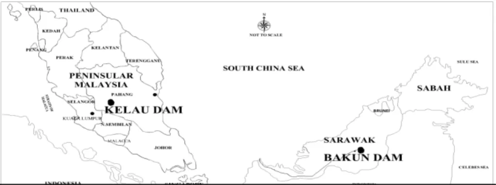
Malaysia is a federation of 13 states which is divided into two regions namely the Malay Peninsula, previously known as Malaya, and East Malaysia which consists of the states of Sabah and Sarawak (Figure 1). The Malay Peninsula covers 132,339 square kilometres while East Malaysia with the states of Sabah and Sarawak covers an area of 73,631 square kilometres.
In this study, the Indigenous’ land rights were affected by the dam projects, namely the BHP and KDP. The BHP is one of Sarawak’s dam projects which was constructed to generate electricity for Sarawak and the Malay Peninsula. It also aims to supply electricity to neighbouring countries such as Brunei, Kalimantan Indonesia and the Southern Philippines. The BHP is situated under the Belaga District which is one of the third districts in the Kapit Division in Sarawak. Belaga is bordered by the Central Kalimantan Region of Indonesia to the south and Brunei to the north.
Topographically the Bakun area is a hilly and predominantly forested region.
On the other hand, KDP is located in the Bentong and Raub Districts. The project is designed to provide raw water from the Pahang State to the Selangor State including the Federal Territories of Kuala Lumpur and Putrajaya.
Both of these projects have directly affected the Orang Ulu and the Orang Asli in the respective states. The total population of the Orang Ulu in 2011
Figure 1. Project locations for the Bakun Hydroelectric Project (BHP) and Kelau Dam Project (KDP) of Malaysia.
Source: Drawn by Nor-Hisham, M-S, 2014
was roughly around 84,775, while the Orang Asli in 2011 were 198,197 (DOS, 2011; DOA, 2012). Prior to the resettlements, both of these Indigenous groups were found to be largely engaged in the agriculture and forest based sectors which include farming, hunting, fishing, gathering as well as small trading and retailing (State Planning Unit of Sarawak (SPU), 1996; DOS, 2011).
5.1 Socio-economic Aspects of the Orang Ulu and the Orang Asli in General
While the poverty rate in Malaysia has been significantly reduced in general, both the Indigenous groups are characterised by a high incidence of poverty. Approximately 15.0 percent of the Orang Ulu and 31.6 percent of the Orang Asli are still considered poor and hard-core poor (DOA, 2012;
Implementation Coordination Unit (ICU), 2012). As shown in Table 2, in the sub-district of Sungai Asap alone there are 4,082 Orang Ulu and there are 36 heads of households of the Orang Asli receiving aid from the Department of Welfare (DOW).
Table 2. Socio-economic aspects of the study areas
Aspects Orang Ulu Orang Asli
Employment Agriculture and forest based activities
Agriculture and forest based activities
Poverty Rate In 2012, 4,082 households received aid from the DOW*
In 2012, 36 received aid from the DOW
Active labour Age Structure
16-30 (32.3%) from 15, 397 16-30 years- 41.6%
Sources: Department of Statistics (DOS), 2012; ICU, 2012; DOA, 2012.
*Including the Sub-District of Sungai Asap which includes outsiders other than the Orang Ulu (beyond the actual population of the RSSA).
In terms of employment opportunities, based on the level of education in the sub-district of Sungai Asap Sarawak, 1,293 of the Orang Ulu have received education at Lower Secondary School. Out of these figures, only 66 people, or 5.1 percent, have completed their tertiary education (DOS, 2012).
On the other hand, by using the drop-out rate in 2011 as an indication, the Orang Asli have recorded a high number of drop-outs. 50 percent of their children have failed to complete primary school (DOA, 2012). In terms of the age structure, both Indigenous populations were in the active age group for the labour force. For the Orang Ulu in Sarawak, out of 15, 397, there were 32.3 percent of them in the 16 to 30 year old bracket. There was an almost similar pattern recorded for the Orang Asli in Sungai Temir Pahang where 41.6 percent of them were in the age group of 16 to 30 years old.
6. RESPONDENTS’ PERCEPTION OF THE NATIVE TITLE (NT)
This section discusses land rights impacts at the two resettlement schemes where survey respondents and interviews were carried out. In sub- section 6.1, this paper provides the socio-economic profile of indigenous respondents at the both the RSSA and RSLB. Section 6.2 then gives the perception of land rights impacts due to the abolition of the NT.
It is important to re-emphasize at this stage that the data presented here are the combined results of these two Indigenous groups. As previously mentioned, the reason for employing such an approach was because this papers main intention is to understand the general patterns of the respondents’
perception on the land rights in general, rather than to make a comparison between these two Indigenous groups.
6.1 Respondents’ profile
As shown in Table 3, there are three variables concerning the respondents’
profile, namely education, occupation and monthly income. It was found that there were as high as 44.1 percent and 32.4 percent of the Orang Ulu and the Orang Asli in the study areas who had no formal education at all.
Meanwhile nearly a quarter or 24.5 percent of the Orang Ulu and 29.7 percent of the Orang Asli, 26.4 percent on average, have completed their education at the Junior High School level. At the high school level, the majority of the Orang Asli (32.4%) have a better educational level compared to the Orang Ulu (26.4%). Meanwhile, at the university level, the Orang Ulu were recorded at 3.63 percent while the Orang Asli were at 5.41 percent only.
Table 3. Respondent Profile of the Orang Ulu and The Orang Asli
Aspect Orang Ulu Orang Asli
Education Total % Total %
University 3 1.4 0 0
College 8 3.6 2 5.4
High School 58 26.4 12 32.4
Junior High School 54 24.5 11 29.7
No Formal Education 97 44.1 12 32.4
Total 220 100 37 100
Current Occupation
Professional and Administrator 6 2.7 0 0
Clerical 3 1.4 0 0
Farmer 164 74.6 32 86.5
Logging worker 18 8.2 0 0
Transport Operator 12 5.5 0 0
Others 17 7.7 5 13.5
Total 220 100 37 100
Monthly Income
RM 450 and below 97 44.1 0 0
RM 451 – RM 700 56 25.5 21 56.8
RM 701 – RM 1,000 41 18.6 14 37.8
RM 1,001 – RM 1,300 6 2.7 0 0
RM 1,3001 – RM 1,600 3 1.4 0 0
RM 1,601 – RM 1,900 8 3.6 2 5.4
RM 2,200 – RM 2,499 6 2.7 0 0
RM 2,500 – and above 3 1.4 0 0
Total 220 100 37 100
Source: Author’s Survey, 2012.
From Table 3, it was found that a substantial number of respondents in the resettlement schemes were working in the farming sector. 74.6 percent Orang Ulu and 86.49 percent Orang Asli were discovered to be farmers. The second highest employment category was logging where 8.8 percent of the
Orang Ulu were found to be involved in this occupation whereas none of the Orang Asli were. 7.7 percent of the Orang Ulu were found to be doing odd jobs including labouring, doing multiple jobs or handcraft.
Perhaps, the most striking finding from Table 3 was the monthly income earned by the respondents. It was found that nearly half of the Orang Ulu (44.1%) earned a monthly income below RM 450.00. Meanwhile, the Orang Asli, a majority of them (56.8%), received a monthly income between RM 451.00 – RM 700.00 which is one ladder better than the Orang Ulu. For the Orang Ulu, 25.5 percent were found earning a monthly income within the bracket of RM 451 – RM 700.00, which is the second highest income. This is followed by the second highest income for the Orang Asli where 18.6 percent of them earn a monthly income of RM 700 - RM1000.00. However, it is important to note that the income figures of the Orang Asli could be misleading because during the survey, they were found to be still receiving an RM683.00 per month compensation for each household. This income was given from the stabilisation programme, a programme under the compensation package.
In comparison to the poverty line at the national level, this research finding on income brackets at these two resettlement schemes has shown an alarming trend. According to Malaysia’s poverty standard, households with a total income of less than or equal to RM 740.00 per month are considered poor in the rural area in the Malay Peninsula and at RM 880.00 for the rural area in Sarawak. Meanwhile, households with a total income of less than or equal to RM 440.00 per month are considered extremely (hard-core) poor (ICU, 2012).
6.2 The loss of land rights due to project implementation
The following six questions from Table 4 were formulated in order to investigate the respondents’ perception on land rights impacts since the Indigenous people have been resettled at both of the new resettlement schemes. Consequently, the displacement has brought about changes in their land laws, for example, their land tenure status has changed from communal land titles to individual land titles. The respondents were asked questions related to the aspects of land rights which were previously enjoyed by them.
In this section, respondents were asked to evaluate the statements using the Likert Scale ranging from strongly agree, agree, uncertain, disagree and lastly strongly disagree. It is important to note here that in discussing each of the issues, the data findings from the interview were incorporated in the discussion.
Table 4. The perception of loss of land rights due to project implementation
Question Strongly
Agree Agree Uncertain Disagree Strongly
Disagree
Total % Total % Total % Total % Total %
Project has reduced free food resources due to the absence of the roaming area.
184 71.6 52 20.2 10 3.9 11 4.3 0 0.0
Project has reduced free food resources since the individual lot is not sufficiently large enough.
184 71.6 61 23.7 3 1.2 4 1.6 5 1.9
No shifting cultivation due to the changes in individual lots’ land tenure.
156 60.7 77 29.4 18 7.0 6 2.3 0 0.0
Increase in illegal agricultural activities on state land because of the insufficient land area.
117 45.5 120 46.7 18 7.0 2 0.8 0 0.0
The amount of the land compensation does not take into consideration the additional increase of family members.
165 64.2 64 24.9 15 5.8 8 3.1 5 1.9
The power of the Customary Council had been reduced due to the changes made to the individual land titles.
51 19.8 153 59.5 39 15.2 8 3.1 6 2.3
Source: Author’s Survey, 2012
It is clearly apparent from Table 4 that the negative responses have dominated all of the six questions provided. The study has found that 71.6 percent of the respondents have strongly and 20.2 percent agreed that both dam projects had reduced their free food resources due to absence of the roaming area in their communal area. To support this finding, perhaps the observation made by Pemanchar Umek Jeno, one of the Orang Ulu leaders can been seen to fit well:
“Previously, if we wanted to get food such as wild boar, deer, fish, fruits and so on, we could just easily find them in our ‘pulau’. The‘pulau’ is our food store. However, since we have resettled here, the ‘pulau’ has simply vanished. Free food is gone, all gone! We now cannot simply go to other areas to find free food as they belong to other parties. So, here everything needs money and without it we cannot live properly” (Interview with Umek, a Pemanchar at RSSA on 29 September 2012).
Batin Cham, the previous headman of the Orang Asli Sungai Temir and RSLB in Kelau Pahang has echoed the same sentiment. He has reasoned why the Orang Asli have to make frequent visits to their original village at the Sungai Temir despite the fact they had already moved to RSLB:
“Life is getting difficult here, everything needs money. We need to buy fish. Even the ferns need to be bought. Previously we could freely pluck them around our village or go to the forest (roaming area) to gather them”
(Interview with Cham, a Batin at RSLB on 24 November 2012).
The second impact was the perception that the projects have reduced the free availability of food due to the insufficient lot size of the individual lots as well as the loss of the communal forest. As shown in Table 4, 71.6
percent of the respondents strongly agreed, while 23.73 percent of respondents agreed with the above statement. Again, the study found that 1.2 percent of the respondents strongly disagreed while 1.3 percent disagreed accordingly. This perception was particularly true of the Orang Ulu in Sarawak who have previously enjoyed huge land areas. For example, prior to resettlement, the largest land size allocated to each family in the Uma Balui Liko Longhouse was 66 hectares while the smallest was in the Uma Buket Longhouse with 3.9 hectares (DOE, 1997). It has shown that the resettlement exercise has considerably changed the size of the land with three acres per household only. It is interesting to quote what Tony Kulleh (Interview with Tony, a Pemanchar at the RSSA on 2 October 2012) has said on this matter:
“Each family was given only three acres of land which clearly were not adequate. That has become one of the main reasons why the local people have lost respect and trust of the government. Being granted an individual land title is nothing and makes no difference to us”.
The Indigenous agriculture system required alternate land which could be used for shifting cultivation (rotation system). This was the system which was predominantly practised by the Indigenous people before they were forced to resettle at the resettlement schemes. Again, this was largely true of the Orang Ulu in Sarawak, however, since each individual household land has been limited to three acres per family, plus there was now no communal forest, shifting cultivation is no longer practised. The introduction of cash crops, namely black pepper and cocoa in the case of the Orang Ulu, or palm oil for the Orang Asli has made it impossible for them to continue with shifting cultivation. In support of this it was found that 60.7 percent strongly agreed and 30.0 percent of them agreed that one of the negative impacts of the project on land rights was that there was no more shifting cultivation practised in the new resettlements schemes.
Illegal farming by the Indigenous people on state land was found to be another manifestation of the loss of land rights. Again, the substantial percentage of the respondents, or 46.69 percent of the respondents who agreed and 45.52 percent of the respondents who responded strongly agreed, were of the opinion that the illegal land encroachment made on the state land by them was due to the limited individual land size compensated to them.
This survey finding was parallel to researcher’s observations at both of the resettlement schemes as well as interviews with both of the Orang Ulu and the Orang Asli. They have admitted that they have illegally expanded their agriculture activities into state land mainly due to the present inadequate land size allocated to them (interview with Cham, a Batin at RSLB on 24 November 2012). According to Tony Kulleh, this was particularly true for families who have expanded yearly (Interview with Tony, a pemanchar at RSSA on 2 October 2012). He went on to say that:
“The three acres of land are insufficient and how can we make a living with just three acres of land? We have to make a decent income to feed our family. In order to get extra income, some settlers have to expand their farm into state land, that’s because they have to.”
Based on the survey and the interviews as shown above, it is clear that the allocation of three acres of land in the case of the Orang Ulu and six
acres of land in the case of the Orang Asli have failed to take into consideration the future of the extended family size of the Indigenous people.
As mentioned earlier, although without formal land titles, the customary system managed to maintain its credibility since the social support of the Indigenous people in the case of land distribution and the future size of the extended family was taken into account. As a result and as shown in Table 4 above, 64.2 percent of the respondents strongly agreed and 24.9 percent agreed that the amount of land compensated did take into consideration the additional increase of family members. There were only a small percentage of respondents (15.8%) who were uncertain, whereas merely 3.11 percent and 1.94 percent disagreed and strongly disagreed respectively that land size had posed no problem to them. It is worth mentioning at this stage too that as a comparison to the FELDA scheme resettlers, who were given 8 to 10 acres at the new resettlement schemes, the treatment of the Orang Ulu and the Orang Asli has clearly been unfair (interview with Nicholas, a Coordinator for Center for Orang Asli Concern (COAC) in Subang Jaya on 25 October 2011).
Another important right in the land rights issue is on the position of the Customary Council. Again, this study found that there was a huge negative perception on land rights. 59.9 percent of the respondents agreed with the statement that there was decreased power and rights of the Customary Council at the new resettlement schemes. Meanwhile, about 19.8 percent of them were strongly agreed on the statement that the power of the Customary Council had been reduced due to the changes made to the individual land titles. It was found that 15.2 percent of respondents were uncertain and 3.1 percent and 2.3 percent disagreed that the Customary Council had decreased its power and rights. The finding was not surprising because the Indigenous Customary Council was no longer entitled to govern land affairs for their own community (Nicholas, 2010).
6.3 Employment and Land Rights Impacts
This section intends to examine the correlation between employment and the land rights impact. The hypothesis postulated here was thst there would be differences between the respondents’ perceptions of the land rights impact and their employment. To validate this hypothesis, this research study has employed an analysis of variance (ANOVA) using the Statistical Package of Social Science (SPSS) software where respondents were asked to evaluate five statements (variables) of perception on land rights impact such as the following: 1) the resettlement schemes or projects (BHP and KDP) have reduced free food resources due to the absence of the roaming area; 2) the resettlement schemes or projects (BHP and KDP) have reduced free food resources since the individual lot allocated was not sufficiently large enough;
3) no shifting cultivation was continued due to the individual and small lots;
4) increase in illegal agricultural activities on government land occurred because insufficient land was compensated; 5) the amount of land compensation did not take into consideration the yearly increase of the additional family members, and; 6) the power of the Customary Council has been reduced due to changes from communal land to individual land titles.
Again, in this section, the results were a combination of the Orang Ulu and the Orang Asli data because the main intention was to illustrate the general pattern of data per se.
Table 5. Mean of perception of land rights impacts by occupation
Occupation Perception of Land Rights Impacts
N Mean Std. Dev.
Professional and administrator 6 4.4167 0.64765
Clerical 3 4.0000 0.60093
Farmer 196 4.4474 0.55553
Logging worker 17 4.4020 0.57148
Transport operator 12 4.0139 0.66080
Others 23 4.3333 0.57953
Total 257 4.4080 0.57014
Using SPSS for the ANOVA analysis, the results were arrived at as in Table 5. It was found that the total overall mean between employment and the perception of land rights impacts was 4.41 which is close to 5 (the maximum score value). It has shown that respondents who have worked as
‘farmer’ would have the highest perception towards the land rights impact scoring an average of 4.44 (SD = 0.56). This was closely followed by
‘professional and administrator’ (M = 4.42, SD = 0.65) and ‘logging worker’
(M = 4.40, SD = 0.57). ‘other occupations’ accounted for an average mean of 4.33 (SD = 0.58) while ‘transport operator’ was placed at lowest with an average mean of 4.01 or 0.66 in SD.
Table 6. Summary results of the Levene’s Test and ANOVA Perception of Land
Rights Impacts
p-value (The Levene’s Test)
Assumption of Homogeneity of Variances
p-value (ANOVA)
Significant Difference
0.801 Yes 0.125 No
Consequently, an ANOVA was carried out as shown in Table 6 which aimed to identify the mean differences in perception towards the land rights of respondents who work as ‘professional and administrator’, ‘clerical’,
‘farmer’, ‘logging worker’, ‘transport operator’, and ‘others’. Table 6 shows the summary results of the Levene’s test and ANOVA. Based on Table 6, the variance was found to be equal to the p-value of the Levene’s test, which was greater than 0.05 (p-value = 0.801). The results also pointed out that there was no statistically significant difference in perception towards land rights impact between occupations at the p > 0.05 level: F (5, 256) = 1.746, p
= 0.125.
From the ANOVA analysis, the results have indicated that those Indigenous groups who were farmers were more affected than those who worked as transport operators who were least affected by the resettlements.
However, in general and based on the Levene’s test, statistically, the respondents were found to have similar negative perceptions towards the land rights impacts regardless of their having different occupations. In other words, land rights impacts were found to produce the same impacts across the different types of employments.