LIQUEFACTION DAMAGES IN THE OSAKI PLAIN, MIYAGI PREFECTURE CAUSED BY THE 2011 OFF THE
PACIFIC COAST OF TOHOKU EARTHQUAKE
Masafumi AOYAMA*
Abstract Extensive liquefaction-induced damages caused by the 2011 off the Pacific coast of Tohoku Earthquake were observed in the Osaki plain, northern part of Miyagi Prefecture. A large number of sand boils were detected in the former river channels, natural levees and refilled gravel pits along the Eai and Naruse rivers. However, sand boils in the study area sparsely occurred rather than the Tone river lowland, Kanto Region. Many liquefaction damages such as uplift of underground structures, subsidence of road surfaces along the sewage line and settlement of ground around building were observed in the central area of Osaki City. This area is located in the back marsh and developed on the paddy fields since the 1970’s, and liquefaction damages tended to be observed in the back marsh (clayey or peaty ground) rather than on the natural levee (sandy ground). Significant damages of the sewage manholes were observed in the clayey or peaty ground. Settlement and tilt of house due to the liquefaction were observed at only a few sites.
Key words:liquefaction, landform classification, land history, The 2011 off the Pacific coast of Tohoku Earthquake, Osaki Plain
1. Introduction
The 2011 off the Pacific coast of Tohoku Earthquake (M=9.0) caused soil liquefaction over a wide area in eastern Japan. Liquefaction-induced damages such as tilt and subsidence of private houses, distortion of river levees and uplift of manholes occurred at numerous sites of the Kanto and Tohoku Regions. In the Kanto Region, extensive liquefaction damages concentrate along the Tokyo Bay area (Yasuda et al. 2012) and the lower reaches of Tone River (Senna 2012;
Wakamatsu 2012; Aoyama et al. 2014). In addition to these areas, liquefaction were also observed in the lowland of Kinu, Kokai, Naka and Kuji rivers (Kanto Regional Development Bureau of Ministry of Land, Infrastructure, Transport and Tourism (KRDB) and Japanese Geotechnical Society (JGS) 2011; Koarai and Nakano 2013; Wakamatsu and Senna 2015).
Recurrence of liquefaction induced by the 2011 off the Pacific coast of Tohoku Earthquake at the same sites where liquefaction had occurred during the previous earthquake was reported (Wakamatsu 2012), and repeated liquefaction induced by the previous earthquake at the same sites has been reported by the previous studies (Yasuda and Tohno 1988; Wakamatsu 2011). Thus, mapping of liquefied sites and description of liquefaction damages are important to evaluate the
* Faculty of Education, Gunma University.
potential areas of liquefaction induced by future earthquakes. Liquefaction damages in the Kanto Region have been reported (KRDB and JGS 2011; Senna et al. 2012; Wakamatsu 2012; Yasuda et al. 2012; Aoyama et al. 2014; Towhata et al. 2014). In the Tohoku Region, a number of the liquefied sites were identified (Yamaguchi et al. 2012; Wakamatsu and Senna 2014). Structural damages due to the liquefaction in the Furukawa area, central area of Osaki City were reported (Yamaguchi et al. 2012; Yoshida et al. 2012), and distortion of river levees induced by the liquefaction were observed and investigated at a number of the sites along the Eai, Shin-Eai and Naruse rivers in detail (Tohoku Regional Development Bureau, Ministry of Land, Infrastructure, Transport and Tourism (TRDB) 2011; Yamaguchi et al. 2012). However, information on the liquefaction of the Tohoku Region is still insufficient.
Thus, the present paper addresses the distribution of the liquefied sites and the liquefaction-induced damages in the Osaki plain, northern part of Miyagi Prefecture except for the liquefaction-induced damages of the river levees. In addition, geomorphological features and land history of the liquefied sites were investigated.
2. Study Area and Methods
The Osaki plain located on the northern part of Miyagi Prefecture, northeastern Japan (Fig. 1) was formed by the fluvial processes of Eai and Naruse rivers (Hase 1967). Japan Meteorological Agency (JMA) seismic intensity about 6 (6+ or 6-) during the 2011 off the pacific coast of Tohoku Earthquake was observed in this area.
Liquefied sites were detected by the field survey and interpretation of the Google Earth images.
The identification of liquefaction was based on the existence of sand boils and structural damages such as a settlement and tilting of residential houses and uplift of manholes. A field survey in the study area was conducted from June 2011 to September 2012. Google Earth images were taken on April 6, 2011. In this study, previous reports of the distortion of river levees (TRDB 2011;
Yamaguchi et al. 2012) were used.
Geomorphological features and land history of the liquefied sites were analyzed by using geomorphological classification maps and old edition maps made by the Geospatial Information Authority of Japan (GSI), aerial photographs and GIS (Arc GIS 10.3.1). In addition, land history of the liquefied sites was also investigated by the documents that records the changes of the river channel of the Eai and Naruse rivers conducted for the river improvement work (e.g. Editorial committee of history of Nango Town 1985).
3. Liquefied Sites and Observed Damages
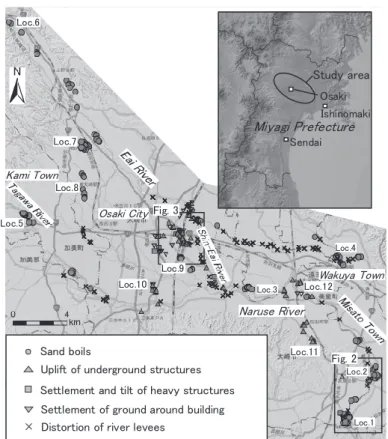
Many liquefied sites and liquefaction-induced damages were detected in the study area. Figure 1 indicates the distribution of liquefied sites and liquefaction-induced damages in the study area.
Sand boils
The occurrence of sand boils were investigated by using the Google Earth images. Sand boils were observed at many sites of the farmland and high-water channel along the Naruse and Eai rivers. Many sand boils and ground cracks were observed in the Kamamaki area, southeastern part of Osaki City (Loc. 1). Subsidences and deformation of the road surface were also observed in this
Fig. 1 Distribution of liquefaction-induced damages in the study area.
area. These liquefaction damages occurred on the natural levees along the Naruse River (Fig. 2).
Many sand boils and ground cracks were also observed in the Nigo area, southern part of Misato Town (Loc. 2). Subsidences and deformation of the road surface, differential settlement of the gravestone and lateral spreading of bank around the small pond were observed in this area (Fig.
2b). These liquefaction damages occurred on the former river channels and natural levees along the Naruse River (Fig. 2). Land reclamations by filled up or drainage in these channels (meander channel) had been conducted before Taisyo era. Sand boils and ground cracks occurred at the former channel of the Matsuyama Shimoibano, southern part of Osaki City (Loc. 3). There are the gravel pits in this site in the first half of 1980’s, and then reclaimed with landfills.
Many sand boils were observed in the Kamiyachi and Nakajima areas, western part of Wakuya Town (Loc. 4). Significant damages (settlement and cracking) of the levees along the Eai River were observed at these areas. These liquefaction damages in the Kamiyachi area occurred on the natural levee and the back marsh. Sand boils in the Nakajima area occurred on the former river channel. Land reclamations by filled up or drainage in this former channel (meander channel) had been also conducted before Taisyo era.
Sand boils were observed along the upstream area of the Naruse River (Tagawa River; Loc. 5), Eai River (Loc. 6), and the western margin of the Osaki plain (Locs. 7 and 8). The gravel pits were excavated since the latter half of the 1970’s, and then reclaimed with landfills at many of these sites. In addition to these sites, sand boils were also observed at the southeastern part of the Furukawa area (Loc. 9), located at the former river channel.
Sand boils
Uplift of underground structures Settlement and tilt of heavy structures Settlement of ground around building Distortion of river levees
Naruse River Osaki City
Kami Town
Wakuya Town Study area
Sendai
Miyagi PrefectureIshinomaki
Osaki
Fig. 2 Fig. 3
Loc.1 Loc.2 Loc.3
Loc.4 Loc.5
Loc.6
Loc.7
Loc.8
Loc.9 Loc.10
Loc.11 Loc.12
Fig. 2 Distribution of topography and liquefaction damages in the southeastern part of Osaki City.
(a) Distribution of topography and liquefaction damages. (b) Lateral spreading of small pond bank in the Nigo area. (c) Sand boils and ground cracks in the Kamamaki area (Google Earth).
Uplift of underground structures and subsidence of road surfaces along the sewage line Uplift of manholes and underground tanks were observed at many sites around the Furukawa station, central area of Osaki City (Figs. 1 and 3). The amount of uplift of manholes and underground tanks was 5 to 10 cm at many of these sites. Maximum uplift of manholes in this area was about 90 cm (Yoshida et al. 2012). Subsidences and deformation of the road surface (pavement) were also observed near these damaged manholes. These damaged sites around the Furukawa station were developed on the paddy fields since the 1970’sin the peat land and back marsh (Fig. 3).
Subsidence of the road surface along the sewage line and uplift of manholes (Fig. 4) were observed in the Sanbongi Minamiyachi, southern part of Osaki City (Loc. 10). This area was developed on the paddy fields since the 1990’s in the back marsh. Significant manhole damages were observed in the Matsuyama Nagao area, southeastern part of Osaki City (Loc. 11). These manholes damages occurred at the foot of the hill slope neighboring the peat land (back marsh).
Maximum uplift of manholes in this area was 75 cm (Fig. 4). The uplifts of manholes were also observed at the eastern area of the Kogota station, Misato Town (Loc. 12). These manholes uplifted 5 to 10 cm. This damaged area was developed on the paddy fields since the 2000’s in the back marsh.
Settlement of ground around building
Offset between an undamaged building and subsided ground were observed at many sites. The gap of about 10 cm between the building foundation and subsided ground were observed around
a
Nigo
Kamamaki
Osaki City
Misato Town
b
back marsh river channel natural levee
high-water channel hill
former river channel
60m 0
c
Sand boils
Uplift of underground structures Settlement and tilt of heavy structures Settlement of ground around building
Distortion of river levees Sand boils and cracks
Fig. 3 Distribution of topography and liquefaction damages in the central area of Osaki City.
(a) Distribution of topography and liquefaction damages. Liquefaction damages tended to be observed in the back marsh rather than on the natural levee. (b) Uplift of manholes near the Furukawa station. (c) Settlement and tilt of the apartment house.
Fig. 4 Liquefaction damages in the southern part of Osaki City.
(a) Subsidence of road surface along the sewage line and uplift of manholes in the Sanbongi Minamiyachi (Loc. 10 in Fig. 1).
(b) Uplift of manholes in the Matsuyama Nagao (Loc. 11 in Fig. 1).
the Furukawa station (Fig. 3). These damaged sites were developed on the paddy fields since the 1970’s inthe back marsh (Fig. 3). Significant damages were observed at the Furukawa Higashi junior high school and the Furukawa gymnasium (Loc. 13; Fig. 3). The gap of about 20 to 40 cm between the building foundation and the subsided ground were observed at these sites. These damaged sites were developed on the paddy fields since the last stage of the 1970’sin the peat
a
Loc. 13 Furukawa station Loc. 14
back marsh river channel natural levee
high-water channel former river channel
b
c
Sand boils
Uplift of underground structures Settlement and tilt of heavy structures Settlement of ground around building
Distortion of river levees
a b
land.
Settlement and tilt of house due to the liquefaction were seldom observed, although uplift of underground structures and settlement of ground around building occurred at many sites in this area. Settlement and tilt of the apartment house were observed near the Furukawa station in the back marsh (Loc. 14; Fig. 3). Sand boils were also observed at this site (Yamaguchi et al. 2012).
4. Geomorphological Features and Land History of the Liquefied Sites
Many sites of sand boils were located on the former river channels of the Eai and Naruse rivers.
The abandoned meander river channels were filled by borrow materials and changed to the paddy filed. Generally, liquefaction resistance of soil increases with age, and the surface soil deposits consisting of young and loose materials were highly susceptible to liquefaction (Towhata et al.
2014). Thus, it seems that the occurrence of sand boils in these former channels were affected by these borrow materials. However, sand boils in these sites sparsely occurred rather than the former river channel of the Tone River, Kanto Region (Aoyama 2014). The areal extent of the former river channels filled by the borrow materials in the study area is narrower than those in the Tone River lowland. Additionally, reclaim of river channels in the study area were prior rather than those in the Tone River lowland. The former river channels in the Tone River lowland had been filled mainly during the 1950’s to 1970’s (Wakamatsu 2012; Aoyama et al.2014). On the other hand, a number of those areas in the study area had been filled before 1950’s. These disparities of land condition and history seem to affect the extents of the liquefaction.
In addition to the former river channels, many sites of sand boils were also located at the refilled lot of gravel pits. These gravel pits in the study area were mostly buried by borrow materials since the 1980’s. Extensive liquefaction occurred at the refilled gravel pits in the Kamisu and Kashima Cities, Ibaraki Prefecture, which were refilled by sandy soils without any compaction since the 1970’s(Ishihara 2012; Tsukamoto et al. 2012; Aoyama and Koyama 2015).
Thus, it seems that the occurrences of sand boils on these refilled lot of gravel pits in the study area were also affected by these refilled materials.
Extensive damages of uplift of underground structures and settlement of ground around building numerously occurred in the back marsh. In particular, several sewage manholes located on the peaty and clayey ground were uplifted more than 50 cm. On the other hand, these extensive damages were not observed on the natural levee. Severe damages of sewage manholes in the peaty ground were also observed after the previous earthquakes (Yasuda and Kiku 2006). Previous studies revealed that the backfill sands of these sewage manholes and underground tanks were so loose that easy to liquefy (Koseki et al. 1997; Yasuda and Kiku 2006). In addition, low permeability of clayey and peaty ground caused long duration of liquefaction of backfill sands in these ground (Yasuda and Kiku 2006). These knowledges suggest that uplift of underground structures and settlement of ground around building in the study area were also affected by liquefaction of backfill materials of these structures.
5. Conclusions
Liquefaction-induced damages and their distribution caused by the 2011 off the Pacific coast of Tohoku Earthquake in the Osaki plain, northern part of Miyagi Prefecture are presented. In
addition, geomorphological features and land history of these liquefied sites were discussed.
Sand boils in the farmland and high-water channel, uplift of underground structures, subsidence of road surfaces along the sewage line, settlement of ground around building and distortion of river levees were observed at many sites, although settlement and tilt of house due to the liquefaction were observed at only a few sites. Many sites of the occurrences of sand boils were located on the former river channels and the natural levees along the Eai and Naruse rivers.
However, sand boils in the study area sparsely occurred rather than the similar setting in the Tone River lowland, Kanto Region. In addition to these geomorphological conditions, a number of sand boils were also observed at the refilled gravel pits. Numerous damages of uplifts of underground structures and settlement of ground around building were observed in the back marsh around the Furukawa station, central area of Osaki City. Liquefaction damages tended to be observed in the back marsh (clayey or peaty ground) rather than on the natural levee (sandy ground) in this area.
Severe damages of sewage manholes occurred on the peaty ground. These damages may have occurred due to the liquefaction of backfill soils of these structures.
Acknowledgements
This paper is dedicated to Professor Haruo Yamazaki on his retirement from Tokyo Metropolitan University. This work was financially supported by JSPS KAKENHI Grant Number 26560155 and the Tokyo Geographical Society.
References
Aoyama, M. 2014. Liquefaction occurrence ratio in the inland area caused by the 2011 off the Pacific coast of Tohoku Earthquake. Proceedings of the General Meeting of the Association of Japanese Geographers 85: 69.*
Aoyama, M., Koyama, T. and Une, H. 2014. Geomorphological Condition and Land History of the Liquefaction Damaged Sites in the Lower Part of the Tone River Lowland Induced by the 2011 off the Pacific Coast of Tohoku Earthquake. Geographical Review of Japan 87: 128–
142.**
Aoyama, M. and Koyama, T. 2015. Correlation between liquefaction areas in Kamisu and Kashima Cities caused by the 2011 off the Pacific coast of Tohoku Earthquake and the time-series changes of distribution of gravel pits.Proceedings of the General Meeting of the Association of Japanese Geographers 87: 138.*
Editorial committee of history of Nango Town. 1980. History of Nango Town. Miyagi: Nango Town.*
Hase, K. 1967. Geology of the Alluvial Plains of Miyagi Prefecture. Contributions from the Institute of Geology and Paleontology Tohoku University 64: 1–45.**
Ishihara, K. 2012. Liquefaction in Tokyo Bay and Kanto Regions in the 2011 Great East Japan Earthquake. Proceedings of the International Symposium on Engineering Lessons Learned from the 2011 Great East Japan Earthquake: 63–81.
Kanto Regional Development Bureau of Ministry of Land, Infrastructure, Transport and Tourism (KRDB) and Japanese Geotechnical Society (JGS). 2011. Report of Clarify Facts of Land Liquefaction Phenomena in Kanto District Induced by the 2011 off the Pacific coast of Tohoku
Earthquake. http://www.ktr.mlit.go.jp/bousai/bousai00000061.html (January 15th, 2016).*
Koarai, M. and Nakano, T. 2013. Liquefaction damages in the Kanto region caused by the 2011 off the Pacific coast of Tohoku Earthquake in Japan, and the land condition of damaged areas detected by time-series geospatial information. Bulletin of the Geospatial Information Authority of Japan 61: 21–32.
Koseki, J., Matsuo, O. and Koga, Y. 1997. Uplift behavior of underground structures caused by liquefaction of surrounding soil during earthquake. Soils and Foundations 37: 97–108.
Senna, S., Hasegawa, N., Maeda, T. and Fujiwara, H. 2012. Liquefaction damages of the Tonegawa basin caused by the 2011 off the Pacific coast of Tohoku Earthquake. Proceedings of the International Symposium on Engineering Lessons Learned from the 2011 Great East Japan Earthquake, 719–730.
Tohoku Regional Development Bureau, Ministry of Land, Infrastructure, Transport and Tourism (TRDB) 2011.Transactions of Restoration Technique for Dike of the Kitakami River, etc.
Tokyo: Ministry of Land, Infrastructure, Transport and Tourism.*
Towhata, I., Maruyama, S., Kasuda, K., Koseki, J., Wakamatsu, K., Kiku, H., Kiyota, T., Yasuda, S., Taguchi, Y., Aoyama, S. and Hayashida, T. 2014. Liquefaction in the Kanto region during the 2011 off the pacific coast of Tohoku earthquake. Soils and Foundations 54: 859–873.
Tsukamoto, Y., Kawabe, S. and Kokusho, T. 2012. Soil liquefaction observed at the lower stream of Tonegawa river during the 2011 off the Pacific Coast of Tohoku Earthquake. Soils and Foundations 52: 987–999.
Wakamatsu, K. 2011. Maps for Historic Liquefaction Sites in Japan, 745-2008. Tokyo: University of Tokyo Press.**
Wakamatsu, K. 2012. Recurrent liquefaction induced by the 2011 Great East Japan Earthquake.
Journal of Japan Association for Earthquake Engineering 12(5): 69–88.**
Wakamatsu, K. and Senna, S. 2014. Liquefaction and their site conditions in Tohoku Region during the 2011 off the Pacific coast of Tohoku Earthquake.Journal of Japan Association for Earthquake Engineering 14(2): 124–143.**
Wakamatsu, K. and Senna, S. 2015. Liquefaction and their site conditions in Kanto Region during the 2011 off the Pacific coast of Tohoku Earthquake. Journal of Japan Association for Earthquake Engineering 15(2): 25–44.**
Yamaguchi, A., Mori, T., Kazama, M. and Yoshida, N. 2012. Liquefaction in Tohoku district during the 2011 off the Pacific Coast of Tohoku Earthquake. Soils and Foundations 52: 811–
Yasuda, S. and Tohno, I. 1988. Sites of reliquefaction caused by the Nihonkai-Chubu Earthquake. 829.
Soils and Foundations 28: 61–72.
Yasuda, S. and Kiku, H. 2006. Uplift of sewage manholes and pipes during the 2004 Niigataken-Chuetsu earthquake. Soils and Foundations 46: 885–894.
Yasuda, S., Harada, K., Ishikawa, K. and Kanemaru, Y. 2012. Characteristics of liquefaction in Tokyo Bay area by the 2011 Great East Japan Earthquake Soils and Foundations 52: 793–810.
Yoshida, N., Yamaguchi, A. and Chiba, K. 2012. Ground failure during the 2011 off the Pacific Coast of Tohoku Earthquake. Japanese Geotechnical Journal 7: 57–66.*
(*: in Japanese, **: in Japanese with English abstract)