1. OUTLINE OF THE STUDY
Government of Japan conducted the study on Landslide Disaster Management in the Republic of Armenia (RA) as request by Government of Armenia.
And the Japan International Cooperation Agency (JICA) selected a team which conducted the Study from March 2004 to December 2005.
2. LANDSLIDE SITUATION IN THE REPUBLIC OF ARMENIA
The JICA study team identified 2,504 landslides using maps, aerial photography and reports of damage.
However, the landslides which are too small to be identified using maps and aerial photography, and those with no damage records were excluded. Of these 2,504 landslides, 68, or around 3%, are causing progressive damage. While those which are dormant with past damage number 77, are also around 3%. No damages have been reported for the remaining 2,359 landslides (around 94%). Around 40% of Armenian settlements are located on land affected by these 2,504 landslides.
According to correlation analysis of the detected landslides, there are estimated to be 53,000 landslides of 1 hectare (ha) or more including landslides that are
Landslide Management by Community Based Approach in the Republic of Armenia
アルメニア国におけるコミュニティ・ベーズト・アプローチによる地すべり管理
アルメニア国は山岳国であり、居住地の40%が地すべり地形上に分布する。国土の年降水量は 一般的に小さいため地すべり地の多くは沈静化している。しかし居住地においては、散水や漏水 が、地すべり活性に大きな影響を与えている。2004年度の調査では全市町村の12%から地すべ り被害が報告されている。パイロットプロジェクトでは、住民参加により、コミュニティ道路の 排水対策が計画・実施され、地すべりの鎮静化と、降雨・融雪時に泥濘化していた村道の改善に 対し顕著な効果が得られた。
Keywords:地すべり、コミュニティ・ベーズド・アプローチ
森 幹尋 * ・細田年晃 * ・石川由基 ** ・津田雅丈 *** ・藤元 亮 **** ・岩間倫秀 *****
Mikihiro MORI, Toshiaki HOSODA , Yuki ISHIKAWA, Masatake TUDA, Ryo FUJIMOTO and Tomohide IWAMA
too small to be identified using map aerial photography, covering a gross area of 2,500 km2, i.e., 8% of the area of RA as shown in Fig.1 and Table 1.
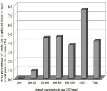
Although landslide area is relatively dense in a large annual precipitation zone found as shown in Fig.2, amount of rainfall in RA is small (200mm/year-1,200 mm year) such that rainfall alone can not explain the landslides development. Therefore leakage/pouring from domestic and irrigation water supply systems may have been the additional cause of landslide activation.
Landslide activation is also significantly associated with snowmelt, when the amount of water in the ground
* コンサルタント海外事業本部 都市社会事業部 都市環境部
**
increases as shown in Fig.3. and Fig.4. And most unpaved community roads become muddy in this snowmelt season as shown in Fig.5.
Fig. 2 Landslide Area Density of Each Annual Precipitation Zone (2,504 identified landslides)
The landslide density is relatively small in near active fault area as shown in Fig 6. The submerged areas along active faults are generally sediment planes and lakes where there are no existing or potential landslide formations. The other, upheaval areas along active faults are new slopes where area density of landslides is small.
However, there is a possibility of new landslides that may have occurred due to seismic activity.
Area ofDisplaced Mass Numbers of
Landslide AccumulatedArea of
Landslides Percentage ofArea of Landslides to whole area ofthe RA
Identified numbers and area based on landslide inventory study
Larger than1000 ha 7 4 2 , 4 2 8 1 . 4 %
7 2 a
h 0 0 1 n a h t r e g r a
L 6 68,442 2.3%
8 5 a
h 0 5 n a h t r e g r a
L 2 8 9 , 6 7 8 3 . 0 %
9 2 , 1 a
h 0 2 n a h t r e g r a
L 6 222,780 3.8%
Estimated value according to correlation analysis based on the number and area of identified landslides (There are not identified landslides which are smaller than 20ha and damages are not reported, because they are too small for map and aerophotograph interpretation).
0 5 , 3 a
h 0 1 n a h t r e g r a
L 0 140,000 4.8%
0 0 , 8 a
h 5 n a h t r e g r a
L 0 170,000 5.8%
0 0 , 3 2 a
h 2 n a h t r e g r a
L 0 210,000 7.1%
Larger than 1 ha 53,000 250,000 8.2%
Fig. 3 Landslide Movement in Gosh Village (December 2004 to March 2005)
Table 1 Numbers and Area of landslides Based on Area of Displaced Mass
Fig. 4 Active landslides block in Gosh Village on 20th of February 2005
Fig. 5 Muddy Community Road by Snow Melting Water in Gosh Village on 20th of February 2005
Fig. 6 Landslide Area Density of Each Distance Zone from Active Faults of 2504 identified landslides
3. LANDSLIDE DAMAGES AND MANAGEMENT BUDGET IN THE RA
Landslides in the RA are categorized into two types, depending on who are affected by the landslides:
• C o m m u n i t y L a n d s l i d e : L a n d s l i d e s t h a t predominantly and directly affect the daily-lives of communities.
• Wide-area Infrastructure Landslide: Landslides that predominately affect inter-community/ inter- regional infrastructure.
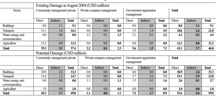
More than 80% of the total sum of direct losses is generated by Community Landslides, while less than 20% is generated by Wide-area Infrastructure Landslides as shown in Table 2.
Landslide management budgets from 2003 to 2005 had been approximately AMD 90-150 million (USD 0.2-0.3 million), which is extremely low proportion (0.02%-0.05%) of the total state budget. The benefit gained by managing a single landslide, is generally small and lower than the cost required for the mitigation measures which may be the reason for small investment in the landslide management.
4. C O N C E P T O F S T R U C T U A L M E S U E R S FOR LANDSLIDE AND DEVELOPMENT OF COMMUNITY INFRASTRUCTURE
Based on the assessment of landslide potential, structure of community, state of infrastructure and economy of RA, following mitigation plans are recommended. Pilot projects were also run to examine the effectiveness of these recommended measures.
Single-purpose projects for landslide damage reduction are generally not a priority due to the lack of cost/benefit justification. Perhaps landslide management projects, which would contribute to community infrastructure development, such as drainage construction for improving muddy road condition to insure passableness by vehicles, should be planed and prioritized. Such projects would generate higher benefits and assure the economic validity of the investment.
Each community plans and implements its own income-generating “community development project”, with financial and a technological support from the government. Communities should reinvest the earnings to the project and also in subsequent “community
The purposes of the projects (effectiveness of projects upon completion) are as follows:
• Reduction in casualty and damage
• Development of community infrastructure for improvement on the daily-lives and industrial development.
• Increase of inhabitant’s incomes and expansion of community budget
5. CONCEPT OF COMMUNITY BASED APPROACH
(CBA) FOR LANDSLIDE MANAGEMENTThe State (managing authorities) is responsible for nationwide landslide management and for providing financial and a technological support to community.
Ministry of Urban Development (MoUD) accumulates information and technologies, and disseminates the information and knowledge to all organizations and personnel concerned with the landslides.
With very limited finances, communities can implement projects using the Community Based Approach (CBA: planning by communities and implementation by inhabitants’ participation). The merits of CBA are the following:
• Inhabitants have much knowledge about the landslide and damage causing by it (risks).
• Inhabitants are the ones who know what resources are available in the community.
• To plan for landslide management and community infrastructure development, it is necessary for inhabitants, communities, to formulate ideas for
Existing Damage at August 2004 (USD million)
Community management/ private Private company management Government organization
management Total
Sector
Direct Indirect Total Direct Indirect Total Direct Indirect Total Direct Indirect Total
Buildings 8.0 1.1 9.1 0.0 0.0 0.0 0.0 0.0 0.0 8.0 1.1 9.1
Transport 15.1 1.0 16.1 0.0 0.0 0.0 3.5 1.4 4.9 18.6 2.4 21.0
Water, energy, and
communication 0.0 0.0 0.0 2.2 0.1 2.3 2.1 0.1 2.2 4.3 0.2 4.5
Agriculture 12.2 0.0 12.2 0.0 0.0 0.0 0.0 0.0 0.0 12.2 0.0 12.2
Total 35.3 2.1 37.4 2.2 0.1 2.3 5.6 1.5 7.1 43.1 3.7 46.8
Potential Damage (USD million)
Community management/ private Private company management Government organization
management Total
Direct Indirect Total Direct Indirect Total Direct Indirect Total Direct Indirect Total
Buildings 30.9 2.4 33.3 0.0 0.0 0.0 0.0 0.0 0.0 30.9 2.4 33.3
Transport 13.4 1.3 14.7 0.0 0.0 0.0 5.7 1.6 7.3 19.1 2.9 22.0
Water, energy, and
communication 0.0 0.0 0.0 1.1 0.0 1.1 1.5 0.1 1.6 2.6 0.1 2.7
Agriculture 1.0 0.0 1.0 0.0 0.0 0.0 0.0 0.0 0.0 1.0 0.0 1.0
Total 45.3 3.7 49.0 1.1 0.0 1.1 7.2 1.7 8.9 53.6 5.4 59.0
Note᧶ The management division is judged in the outline according its sector for management and scale.
Table 2 Damage due to Landslides Table 2 Damage due to Landslides
managing those risks.
• Inhabitants can check and maintain community infrastructure such as water supply and drainage facilities, on a daily basis after they receive technical guidance from the specialist. They can also attend to daily landslide monitoring. Performance of these tasks by residents will increases efficiency and decreases the cost.
6. CONCEPT OF CRISIS MANAGEENT FOR LANDSLIDE HAZARD
Community public offices organize the landslide monitoring teams for early stage detection of any disaster signs. Heads of communities warn inhabitants and recommend the evacuation of concerned inhabitants depending on the “index value (threshold)” for landslide monitoring, including precipitation levels, and early signs of landslides, etc. When a disaster occurs, operations to ensure the safety of residents and/or rescue of victims are conducted under the supervision of the head of the community, with support from the Armenian Rescue Service (ARS), Regional Government Administration (Marz) and local inhabitants.
MoUD and ARS will provide the technical support for the setting of the “index value (threshold)” for landslide movement, precipitation, and other signs for early warning, recommendation of site evacuation, and limitation on the use of facilities.
7. OUTLINE OF PILOT PROJECTS
Three Pilot Projects were conducted from May to December 2005 in Gosh Village, Martuni Village and Kapan City supported by the JICA Study Team.
The purpose of this pilot projects was to test and confirm the effectiveness of the ‘Community Based Approach (CBA)’. Pilot projects have become multipurpose projects, which contribute to community infrastructure development. The participation of inhabitants reduces construction costs, resulting in possible transformation of the pilot projects into economically feasible projects.
‘The landslide management and community infrastructure development’ and ‘the community development concept plan for acquisition of project resources’ were formulated by the working commissions in the communities.
Parts of plans, including community road drainage works, landslide monitoring and an early warning system, were started through the participation of the local inhabitants.
Stakeholder meetings (advisory committees) were chaired and held by the MoUD and technical support such as conduction of environmental assessment was provided through these committees.
Plans for “landslide mitigation works which contribute to community infrastructure development” formulated from the Pilot Projects of Gosh and Martuni Villages, were assessed as economically feasible. The Pilot Project in Kapan involving hazard recovery works (opening of 2-lanes of Harutyunyan Street) was economically beneficial in keeping regional traffic safe, including the flow of bulky international cargo, which is the major means of trade across the Iranian border. The projects are highly recommended for implementation.
The Study Team together with communities in the area undertook landslide monitoring. Monitoring technologies were transferred to the communities and monitoring systems were established and put into the operation.
8. SIMPLE LANDSLIDE MANAGEMENT PLAN OF GOSH VILLAGE PILOT PROJECT
Plan of landslide management and community infrastructure development of Gosh Village is shown in Table 3.
Item Outline
Feature of landslide, risk resource assessment
-It is 1000m wide, 500m long, and is divided into 15 sub-blocks. Risk objects are houses and community roads. The roads across H block which is important for access to pasture and tourism.
- H block (100m long, 50m width) is active. During Jan-Sep 2005 (before drainage works), landslide movement was approximately 10mm/day. In snow melting season, Mar 2005, the movement was 75mm/day. In winter, inhabitants were watering using domestic water to prevent frozen of water systems.
This aggravated the landslide activity. H block damaged 4 houses and the important community road.
- C block and J block are also active (1mm/day to 10mm/day movement), other blocks are not active (less than 1mm/day movement).
- Resources are itemized (farmland, sand and rock mines, and lake and monastery for tourism).
Landslide Management
and Community
Infrastructure Development
- As project resource acquisition, tourism development (tourist home, eco tourism, agriculture and stockbreeding development ( juice, meat, dairy processing) were planned.
- Execution system (landslide monitoring team, working commission, and community staff) was formulated.
- Drainage works against assumed main causes (precipitation, thawed water, watering) was planned. It will be installed as community road drainage, will prevent the road becoming muddy, and ensure running of vehicles all year. (This pilot project and forward plan: 770m length open ditch with conduit, 160m long conduit, 1,480m long open ditch, 570m long horizontal drainage boring, 1,830m long road stone pavement) Executed Activities - In Sep-Dec 2005, 470m long open ditch with conduit, 160 meter long conduit, 400 meter long horizontal
drainage works were installed at H block. Activity of H block is reduced. Boring and material procurement were input by Japan with local contractor. Community input is general workers (Japan assisted about 1/3-of
Table 3 Plane of Gosh Village Table 3 Plane of Gosh Village
9. ECONOMIC EVALUATION ON COMMUNITY BASED LANDSLIDE MANAGEMENT PROJECTS
Estimated benefits of the three pilot projects are summarized in Table 4.Table 4 Estimated Benefits in Pilot ProjectsTable 4 Estimated Benefits in Pilot Projects
Item Kapan Gosh Martuni
Direct
Damages AMD 0 USD 0
AMD235,905,000 USD 519,000
AMD482,506,000 USD 1,062,000
Indirect
Damages AMD 3,300,000
USD 7,300 AMD 41,155,000 USD 91,000
AMD61,613,000 USD 136,000 WTP1)of the
Whole Community Inhabitants
AMD14,411,000 USD 32,000
AMD 2,375,000 USD 5,000
AMD1,463,000 USD 3,000
Total AMD
17,711,000 USD 39,000
AMD279,435,000 USD 415,000
AMD545,582,000 USD 1,200,000 Ratio of
WTP to Direct Damage (percentage)
- 1.2㧑 1.1䋦
1) WTP (Willingness to pay) is calculated by CVM (Contingent 1) WTP (Willingness to pay) is calculated by CVM (Contingent
Valuation Method)
“WTP (Willingness to pay) of the whole community inhabitants” in Table 4 was calculated by a simplified CVM (Contingent Valuation Method ). This survey was
conducted in three sites using a questionnaire asking WTP for the projects, which potentially represents the project worth for the residents. The result of WTP in each site is outlined in Table 5.
The CVM result is an estimation of monetary value of regional economic effect taking into consideration upgrading of the land use, improving regional roads, expected budget saving for villages, and incorporating landslide management into multipurpose programs of regional development. Therefore, willingness to pay includes the benefits of the project.
Table 5 Result of CVM in Each of the Pilot Project SitesTable 5 Result of CVM in Each of the Pilot Project Sites
Item Kapan Gosh Martuni
Annual
Income/Household
882,000 AMD USD 1,940
AMD 582,000
USD 1,280 AMD 576,000 USD 1,267 Willingness to
Pay/Household (Weighted Average)
AMD1,550
USD 3 AMD5,951
USD 13 AMD8,083 US 18 Percentage of
Annual Income to Willingness to Pay
0.2% 1.0% 1.4%
Whole City/Village
14,411,110 AMD 31,704 USD
AMD2,374,504
USD 5,223 AMD1,462,937 USD 3,218
Fig. 7 Landslide Sub-blocks in Gosh Village
Costs of the implementation of engineering countermeasures are estimated based on the basic design prepared by the communities and unit costs per construction work obtained under the pilot projects in the respective sites, are shown in Table 6. Engineering countermeasures are planned with inhabitants’ participation. Therefore costs are cheaper than contractor’s estimates.
Table 6 Construction CostTable 6 Construction Cost
Item Kapan Gosh Martuni
Const ructio nCosts
AMD 98,293,000 USD 216,245
AMD115,579,00 USD 254,274 0
AMD628,796,00 0USD 1,383,351
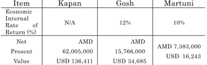
With the above project benefits (quantified) and costs, cost-benefit analysis was carried out and the results are presented Table 7.
Table 7 Results of Economic Evaluation for Three Pilot ProjectProjects
Item Kapan Gosh Martuni
Economic Internal Rate of Return (%)
N/A 12% 10%
Net Present
Value
AMD 62,005,000 USD 136,411
AMD 15,766,000 USD 34,685
AMD 7,383,000 USD 16,243 At Kapan, Plan is securing 2 lane traffic of Harutyunyan Street At Kapan, Plan is securing 2 lane traffic of Harutyunyan Street
The results for Gosh and Martuni show positive Net Present Value (NPV) and higher Economic Internal Rate of Return (EIIR) than the discount rate of 10%. This indicates that these projects are economically viable for implementation. The earliest implementation will be required to protect the village properties and avoid the economic losses incurred by landslides. Although the Pilot Project in Kapan shows a negative NPV, it is extremely important for the Armenian economy to secure regional safe traffic and moreover international large cargoes, which are the key means of trade through the Iranian border. The project is highly worthy for implementation with Plan II, which offers a much less negative NPV than Plan III.
10. CONCLUSION
One of the reasons which hindered the RA from undertaking landslide mitigation projects has been the lack of public funds due to severe constraints in the state budget and the small benefit generated by existing projects that aim solely at landslide mitigation.
The pilot projects became economically feasible by expanding the benefit streams and by transforming them into multipurpose projects which contribute to community infrastructure development. Costs were also reduced through the participation of local inhabitants in project implementation. Residents’ awareness of self- help and mutual aid were markedly improved along with the improvement of community infrastructure and settlement of landslide activities.
‘Community Based Approach (CBA)’ has been proven as useful for effective project formulation. While the initial investment requirements and specialists in communities are still scarce, public participation and inputs in the technical and financial aspect are needed to insure the sustainability of the pilot projects and implementation of new projects.
Therefore not only CBA is important but also the responsibility of State (management authorities) to nationwide landslide management and the provision of technical/ financial assistance to implementation bodies of landslide management (communities and management organization for wide area infrastructure).
ACKNOWLEDGEMENT:The author wishes to thank all related parties of Japan International Cooperation Agency for their advice for the Study. Acknowledgment is also duly given to members and assistants of the study team on the landslide disaster management in the Republic of Armenia, and many Armenian concerned organizations and personnel.
REFERENCES
1) Japan International Cooperation Agency, Final report of the Study on Landslide Disaster Management in the Republic of Armenia, pp.1-165, 2006.