JAMSTEC深海研究 第18号
71
伊豆・小笠原弧,孀婦岩構造線周辺の潜航調査
富士原敏也
*1湯浅 真人
*2渡辺 暉夫
*3新井田清信
*3西村 昭
*2坂本 泉
*1石塚 治
*2今村 牧子
*4佃 薫
*4我々は2000年9月に「よこすか/しんかい 6500」YK00-08航海を行い,伊豆・小笠原弧,孀婦岩構造線周辺において,合計8
潜航の潜航調査を行った。#570で潜航調査を行った大町海山本体の西斜面から採取された火山岩は角閃石デイサイトおよび
斑状の閃緑岩である。#571,#575で潜航調査を行った斜面の基底には,上部マントルかんらん岩起源の蛇紋岩と,マグマ溜
まりでできたキュムレイト起源の蛇紋岩が広く露出していた。得られた試料中には,新鮮な輝石とかんらん石が含まれる。孀
婦岩構造線の北西部に分布する背弧海丘群の小海丘は,山体斜面の露頭は枕状やシート状の溶岩流とその崩壊物,火山噴
出物で構成されていると思われるが,表層岩石はすべてマンガンで覆われている。斜面の傾斜が潜航を通じてほぼ一定で,
側噴火を示唆する地形が現れないことから,活動様式は単成火山と思われる。この#573小海丘からは,かんらん石玄武岩,
#
574小海丘からは単斜輝石玄武岩が採集された。西七島海嶺,文化海山東側の崖を登るような測線では火山体内部あるい
はその基盤岩の露出を観察できる可能性があったが,#572で潜航調査を行った斜面は,すべて厚いマンガンクラストに覆われ
ていた。天保海山南西凹地の西側と東側の崖を登るように各1潜航,計2潜航を行った。西側の崖の測線では,四国海盆初期
発達過程の地殻が露出している可能性がある。東側の崖の測線では,孀婦岩構造線(#339, #365, #366, #367, #368)
より下位
に存在する島弧地殻が観察できると期待されたが,#576, #577で潜航を行った天保凹地斜面は,厚い堆積物とマンガンクラス
トに覆われており,下位層を観察するという目的は達せられなかった。両潜航とも斜面に平行な方向に,最近の活動を推定さ
せる,堆積物を切る急崖や亀裂が見られた。
キーワード:伊豆―小笠原弧,孀婦岩構造線,島弧,リフト
Submersible study around the Sofugan Tectonic Line, Izu-Bonin Arc
Toshiya FUJIWARA
*5Makoto YUASA
*6Teruo WATANABE
*7Kiyoaki NIIDA
*7Akira NISHIMURA
*6Izumi SAKAMOTO
*5Osamu ISHIZUKA
*6Makiko IMAMURA
*8Kaoru TSUKUDA
*8We conducted submersible surveys around the Sofugan Tectonic Line, Izu-Bonin Arc, western Pacific, during the
"Yokosuka/Shinkai
6500" YK00-08 cruise. Hornblende dacite and diorite porphyrite rocks were sampled from the western wall of
Ohmachi Seamount in Dive #
570. Upper mantle-derived and cumulate-derived serpentinites were widely exposed at the base of
western wall of the Ohmachi Seamount in Dive #
571 and #575. Some samples are considerably fresh and containing primary
pyrox-enes and olivines. The small knolls located in the back-arc region in the northwest of the Sofugan Tectonic Line, the seafloor
appeared to be composed of pillow lavas, sheet lavas, and pyroclastic rocks, however thick manganese crust prevented visual
obser-vation. The slopes were almost constant through the dive tracks, therefore there was no evidence of lateral eruption. This suggests
*1 海洋科学技術センター
*2 地質調査所
*3 北海道大学
*4 日本海洋事業
*5 Japan Marine Science and Technology Center
*6 Geological Survey of Japan
*7 Hokkaido University
*8 Nippon Marine Enterprises
72
JAMSTEC J. Deep Sea Res., 18(2001)
that these knolls are monogenetic volcanoes. Olivine basalts were sampled in Dive #
573, and clinopyroxene basalts were sampled in
Dive #
574. The eastern wall of Bunka Seamount of the Nishi-shichito Ridge was wholelly covered by thick manganese crust, which
protected sampling work, in Dive #
572. Two dives were devoted to western and eastern walls in a deep graben located in the
south-west of Tempo Seamount. These walls were covered with thick sediments and manganese crust, and we could not observe and
sam-ple the seafloor rocks which were considered to be the island-arc crust below the cliff of Sofugan Tectonic Line. Small gaps and
fis-sures which cut sediment were observed. These suggest recent tectonic activity.
Keywords : Izu-Bonin Arc, Sofugan Tectonic Line, Island Arc, Rift
我々は過去4年間をかけて,伊豆・小笠原弧,孀婦岩構
造線周辺の調査航海を行ってきた
(坂本他,1997;坂本他,
1999;湯浅他,1999a;湯浅他,1999b)
。1996, 1997年の潜
水調査船「しんかい6500」の潜航調査の結果,孀婦岩構造
線は新しい時代(2 Ma)
においても活動していることが明ら
かになり,以前の研究から提案されていた構造発達史
(Yuasa, 1985;湯浅・村上,1985;湯浅,1991)
は改変を余
儀なくされている
(Sakamoto et al., 2000)
。また1996, 1997,
1999, 2000年の調査船「よこすか」の調査により作成された
詳細な海底地形図(図2)
は,テクトニクスを議論しうる断層
の分布と走向のマッピングを可能とし,孀婦岩構造線の北
西部に,直径2∼5km,比高300∼800mの小海丘群が存在
することも明ら か に なった( Sakamoto et al., 2000)。
1. はじめに
伊豆・小笠原弧の孀婦岩構造線周辺では,島弧地殻が
孀婦岩構造線という断層によって分断され露出しているた
め,
目視地質観察,岩石採集が容易である
(図1)
。したがっ
て潜航調査による海洋性島弧の形成発達史,テクトニクス
およびダイナミクスの研究,島弧発達過程の各段階に伴わ
れるマグマティズムの研究のためには,絶好のフィールドで
ある。
また孀婦岩構造線が位置する南部伊豆・小笠原弧は,
その北部に対比して異なる地質・地球物理学的性質をもっ
ており
(Yuasa, 1985;湯浅・村上,1985;湯浅,1991)
,その
対比を研究することは,北部伊豆・小笠原弧で提案された
島弧∼大陸形成のシナリオ
(Suyehiro et al., 1996; Taira et
al.,
1998)
を検証する上で重要である。
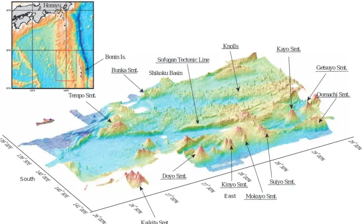
139˚ 00'E
139˚ 30'E
140˚ 00'E
140˚ 30'E
141˚ 00'E
26˚ 00'N
26˚ 30'N
27˚ 00'N
27˚ 30'N
28˚ 00'N
28˚ 30'N
29˚ 00'N
29˚ 30'N
135˚E 140˚E 25˚N 30˚N 35˚N 135˚E 140˚E 25˚N 30˚N 35˚NHonsyu
Bonin Is.
Shikoku Basin
Tempo Smt.
Bunka Smt.
Sofugan Tectonic Line
Knolls
Kayo Smt.
Getsuyo Smt.
Oomachi Smt.
South
Kaikita Smt.
Doyo Smt.
Kinyo Smt.
Mokuyo Smt.
East
Suiyo Smt.
図1
伊豆・小笠原弧,孀婦岩構造線周辺地域の概略図。
我々はこの小海丘群の存在が,島弧リフティングの発達段
階において本質的な過程である可能性を指摘している
(Fujiwara et al., 2001)
。しかしながら,これらの議論,可能
性を実証するための十分な岩石試料が得られておらず,火
成活動史および構造発達史は未解明のままである。その
ため我々は2000年9月に「よこすか/しんかい
6500」YK00-08 Leg 1航海を行い,この地域のキーポイントにおいて,
#
570∼#577までの8潜航調査を行った。各潜航においては
海底目視観測,岩石試料の採集,また地質調査所所有の深
海磁力計を潜水船に搭載し海底地磁気測定を行った。本
論文ではこの調査航海の概要を報告する。
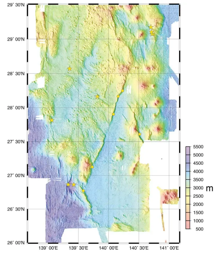
2.「よこすか」YK00-08 Leg 1航海の概要
海洋科学技術センター調査船「よこすか」と潜水調査船
「しんかい6500」のYK00-08 Leg 1航海は,2000 年9月1日か
ら9月21日にかけて行われた。本航海の潜航点を図2中に星
印で示す。前弧に位置する大町海山の西側斜面では3潜航
(#570, #571, #575)
を行った。古島弧の深部を形成していた
と考えられる大町海山の,基盤岩をねらい採取した岩石に
ついて,全岩化学分析,年代測定を行い,岩類の性質と形
成年代,受けている変成作用の性質を明らかにすることが
目的である。孀婦岩構造線北西部の背弧小海丘群の2海丘
では,各1潜航の2潜航(#573, #574)
を行った。岩石の産状
を目視観察し,海丘の成長過程を明らかにし,採取岩類の
性質と形成年代を明らかにすることが目的である。西七島
海嶺の文化海山の東側斜面で1潜航(#572)
を行った。この
測線では火山体内部あるいはその基盤岩の露出を観察で
きる可能性がある。天保海山の南西側の凹地では西側と東
側の崖を登るように各1潜航,計2潜航
(#576, #577)
を行った。
この凹地は,この海域で最も水深の深い構造性の凹地であ
る。西側の崖の測線では,四国海盆初期発達過程の地殻が
露出している可能性がある。東側の崖の測線では,孀婦岩
構造線(#339, #365, #366, #367, #368)
より下位に存在する島
弧地殻が観察できると期待される。
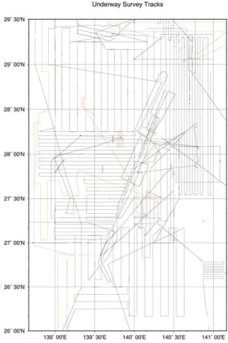
潜航調査を行わない夜間,および潜水船整備日は航走調
査により,海底地形,地磁気,重力データを取得した(図3)。
調査測線は,
過去の調査の欠測域である西ノ島トラフ北部,
文化海山の南側を補完するように設けた。また,北側と西
側に調査域を拡大した。本航海では#573, #574潜航の小
海丘上の地磁気,重力異常を調べるため,1マイル間隔の
密な測線を設けた。地磁気調査は船尾から350m曳航した
プロトン磁力計と船上3成分磁力計により行われた。3成分
地磁気データの船体磁化の影響の補正のための「8の字」
航走は,9月19日07:30-07:50と9月20日09:10-09:35の2回行わ
れた。地磁気異常は国際標準磁場(IGRF 1995)からの残
差 により求 め た 。重 力 調 査 は 船 上 重 力 計 LaCoste &
Romberg S-
63により行 わ れ た 。船 上 重 力 計 の 測 定 値
(10867.7 mgal)
を海洋科学技術センター岸壁における絶対
重力値(979758.2 mgal)
と結合した。重力異常は正規重力
式1967との残差により求めた。海底地形調査はマルチナ
ロービーム音響測深機SeaBeam 2112により行われた。
3.「しんかい6500」潜航調査結果
3.1. 大町海山西側斜面
1996年の潜航調査測線(#341)
と並行し,大町海山西側
斜面の崖を登るように測線を3本設けた。#570で潜航調査
を行った大町海山本体の西斜面から採取された火山岩は
角閃石デイサイトおよび斑状の閃緑岩(表1)
で,フィリピン海
形成史初期,四国・パレスベラ海盆形成前に存在した小大
陸を構成した地殻の一部である可能性がある。#571,
#
575で潜航調査を行った斜面の基底には,上部マントルか
んらん岩起源の蛇紋岩と,マグマ溜まりでできたキュムレイ
ト起源の蛇紋岩が広く露出していた
(表1)
。得られた試料
中には,新鮮な輝石とかんらん石が含まれる。採集された
岩石よりマントルの性質やキュムレイトをつくったマグマの
性質を求め,かつ蛇紋岩体の中から採取された角閃岩の
年代を決定できれば,古小笠原弧のリソスフェア復元の研
究への貢献が期待される。
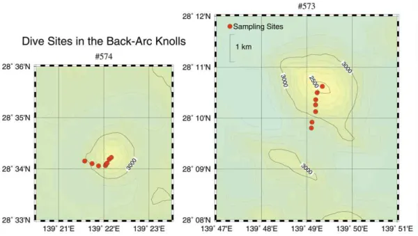
3.2. 孀婦岩構造線北西部小海丘群
孀婦岩構造線北西部には,構造線に平行なN25°E の走
向を持つ基盤の上に数百の小海丘が点在する
(図4)。海
丘の長軸の方向が N40∼60°W の小海丘が多く見られる
が,方向性を持たない小海丘も数多くある。潜航する小海
丘は,異なる地形の高まりからそれぞれ1つを選択した。
#
573小海丘は直径約3km,比高約800mで,長軸がN55°W
の方向性を持つ。#574小海丘は直径約2km,比高約600m
で方向性を持たない円形の海丘である
(図5)
。
両海丘とも山体斜面の露頭は,枕状やシート状の溶岩流
とその崩壊物,
火山噴出物で構成されていると思われるが,
表層岩石はすべてマンガンで覆われている。斜面の傾斜
が潜航を通じてほぼ一定で側噴火を示唆する地形が現れ
ないことから,活動様式は単成火山と思われる。#573小海
丘からは,多孔質で,かんらん石を多く含むことが特徴の
玄武岩が採集された
(表1,写真1)
。#574小海丘からは,多
孔質で,単斜輝石を多く含むことが特徴の玄武岩が採集さ
れた
(表1,写真1)。#574の玄武岩は#574の玄武岩に比べ
てガラス質石基で構成され,急冷されたことを示す。この
形態の違いは溶岩として噴出した時の冷却過程の違いと
考えられる。#573の玄武岩にかんらん石が多く含まれ,
#
574玄武岩にそれが少ないことは,火山を形成したマグマ
のタイプや性質の違いによるものと思われる。今後の化学
分析と年代結果を得ることによって,この海域に広く分布す
る小海丘群のマグマ系の全体像を明らかにするための,
有力な情報を得ることができると期待される。小海丘の各
潜航では潜水船に可搬重力計LaCoste & Romberg G-1039
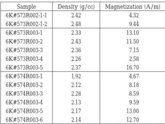
を船内に持ち込み,麓と頂上にて2点海底重力測定を行っ
た
(表2)。また全潜航で行われている海底地磁気測定,こ
れらの測定と試料岩石の密度,磁化測定
(表3)
と合わせて,
マンガン被覆のため目視観測できず,十分に岩石採集でき
なかったため不明である海丘全体を構成している岩石を
推定できるだろう。
73
JAMSTEC J. Deep Sea Res., 18(2001)
74
JAMSTEC J. Deep Sea Res., 18(2001)
図2
調査域の海底地形図。丸印は既存の「しんかい6500」潜航点,星印はYK00-08 Leg 1航海における潜航点を示す。
75
JAMSTEC J. Deep Sea Res., 18(2001)
3.3. 文化海山東側斜面
この測線では火山体内部あるいはその基盤岩の露出を
観察できる可能性があったが,#572で潜航調査を行った
斜面は,すべて厚いマンガンクラストに覆われていた。採
集された試料の軽石は異地性であるが,スコリアとマンガ
ン団塊は現地性と考えられる
(表1)。しかしスコリアはマ
ンガン被覆が大変薄く,採取されたマンガン団塊,クラスト
の厚さ
(表1)から類推して,文化海山本体を形成した火山
活動に直接由来する可能性は少ないと考えられる。
3.4. 天保海山南西凹地
#
576, #577で潜航を行った天保凹地斜面は,厚い堆積
物とマンガンクラストに覆われており
(表1),下位層を観察
するという目的は達せられなかった。両潜航とも斜面に平
行な方向に,最近の活動を推定させる,堆積物を切る急
崖や亀裂が見られた。
謝辞
YK
00-08航海において今井義司司令をはじめとする
「し
んかい6500」運航チーム,田中等船長をはじめとする
「よこ
すか」乗組員の潜航,航走調査における協力に感謝する。
山崎俊嗣氏には地質調査所の深海磁力計を貸与いただい
た。小寺透氏には海底地形データの処理に助力をいただ
いた。大河原有子氏,石川布美子氏には岩石試料の整理
に協力をいただいた。
引用文献
Fujiwara, T., T. Yamazaki, and M. Joshima
(2001):
Bathymetry and magnetic anomalies in the Havre Trough
and southern Lau Basin: From rifting to spreading in
back-arc basins, Earth Planet. Sci. Lett.,
185(3-4),
253-264.
Geological Survey of Japan
( GSJ)and Coordinating
Committee for Coastal and Offshore Geoscience
Programmes in East and Southeast Asia
(CCOP)
(1996):
Magnetic anomaly map of east Asia
1:4,000,000
CD-ROM Version.
坂本泉・佐々木智之・藤岡換太郎(1997)
:孀婦岩構造線付
近で観察された海洋性島弧上部の火山地質学的特徴
(1)
.JAMSTEC深海研究,13, 479-494.
坂本泉・P. A. Jarvis・沖野郷子・青木美澄・観田悟・柏瀬憲
彦(1999)
:孀婦岩構造線周辺の地質学的・記載岩石
学的特徴―YK97-04 航海の結果報告―.JAMSTEC深
海研究,14, 279-299.
図4
背弧小海丘群周辺の海底地形図。等高線間隔は100m。星印は
YK
00-08 Leg 1航海における潜航点を示す。
Fig.
4
Bathymetric map around the back-arc small knolls. Contour interval
is
100 m. Stars show dive points of the YK00-08 Leg 1 cruise.
図3 「よこすか」航走調査の航跡図。赤線がYK00-08 Leg 1航
海の航跡を示す。
Fig.
3
Survey ship tracks of R/V Yokosuka. Red lines indicate
the tracks during the YK
00-08 Leg 1 cruise.
76
JAMSTEC J. Deep Sea Res., 18(2001)
図5
#
573小海丘(右)
と#574小海丘(左)
の海底地形図。等高線間隔は100m。丸印は岩石採集点を示す。
Fig.
5
Bathymetric map of the #
573 knoll (right) and the #574 knoll(left). Contour interval is 100 m. Circles show rock sampling sites.
写真1
岩石試料6K#573R003(左)
と6K#574R003(右)の断面写真と顕微鏡写真。ol=かんらん石,cpx=単斜輝石,pl=斜長石,
ves=
気泡。
Photo
1
Photographs of sample and thin section of
6K#573R003(left)and 6K#574R003(right). ol=olivine, cpx=clinopyroxene,
77
JAMSTEC J. Deep Sea Res., 18
(2001)
表1
採集された岩石の記載表
Table
1
Tables of sampling rock descriptions.
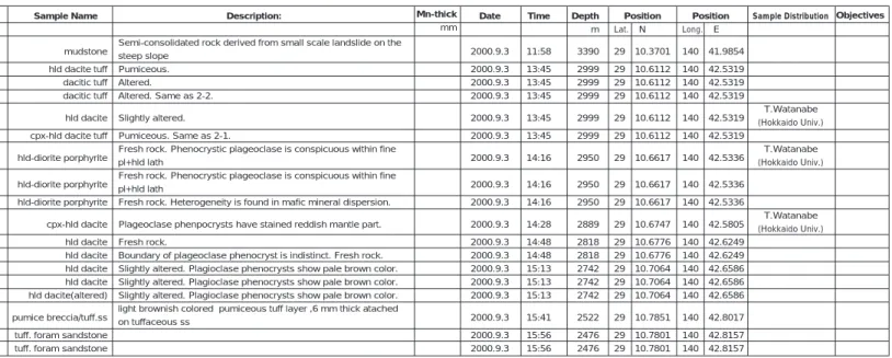
Sample No. #570R001 #570R002-1 #570R002-2 #570R002-3 #570R002-4 #570R002-5 #570R003-1 #570R003-2 #570R003-3 #570R004 #570R005-1 #570R005-2 #570R006-1 #570R006-2 #570R006-3 #570R007 #570R008-1 #570R008-2 Size cm 21*19*11 28*20*19 14*12*7 12*9*6 24*18*15 31*14*11 15*9*7 15*10*6 19*8*7 25*14*13 17*13*10 33*25*12 15*10*7 13*10*4 14*12*6 27*14*8 30*12*8 18*12*8 Weight kg 2.5 12.0 1.1 0.6 8.5 5.5 1.1 1.0 1.6 7.5 2.9 10.7 1.3 1.1 1.2 2.9 2.6 1.7 SampleType sed.rock ign.rock ign.rock ign.rock ign.rock ign.rock ign.rock ign.rock ign.rock ign.rock ign.rock ign.rock ign.rock ign.rock ign.rock sed.rock sed.rock sed.rock Sample Name mudstone hld dacite tuff dacitic tuff dacitic tuff hld dacite cpx-hld dacite tuff hld-diorite porphyrite hld-diorite porphyrite hld-diorite porphyrite cpx-hld dacite hld dacite hld dacite hld dacite hld dacite hld dacite(altered) pumice breccia/tuff.ss tuff. foram sandstone tuff. foram sandstone
Description:
Semi-consolidated rock derived from small scale landslide on the steep slope Pumiceous. Altered. Altered. Same as 2-2. Slightly altered. Pumiceous. Same as 2-1.
Fresh rock. Phenocrystic plageoclase is conspicuous within fine pl+hld lath
Fresh rock. Phenocrystic plageoclase is conspicuous within fine pl+hld lath
Fresh rock. Heterogeneity is found in mafic mineral dispersion. Plageoclase phenpocrysts have stained reddish mantle part. Fresh rock.
Boundary of plageoclase phenocryst is indistinct. Fresh rock. Slightly altered. Plagioclase phenocrysts show pale brown color. Slightly altered. Plagioclase phenocrysts show pale brown color. Slightly altered. Plagioclase phenocrysts show pale brown color. light brownish colored pumiceous tuff layer ,6 mm thick atached on tuffaceous ss Date 2000.9.3 2000.9.3 2000.9.3 2000.9.3 2000.9.3 2000.9.3 2000.9.3 2000.9.3 2000.9.3 2000.9.3 2000.9.3 2000.9.3 2000.9.3 2000.9.3 2000.9.3 2000.9.3 2000.9.3 2000.9.3 Time 11:58 13:45 13:45 13:45 13:45 13:45 14:16 14:16 14:16 14:28 14:48 14:48 15:13 15:13 15:13 15:41 15:56 15:56 Depth m 3390 2999 2999 2999 2999 2999 2950 2950 2950 2889 2818 2818 2742 2742 2742 2522 2476 2476 Position Lat. N 29 10.3701 29 10.6112 29 10.6112 29 10.6112 29 10.6112 29 10.6112 29 10.6617 29 10.6617 29 10.6617 29 10.6747 29 10.6776 29 10.6776 29 10.7064 29 10.7064 29 10.7064 29 10.7851 29 10.7801 29 10.7801 Position Long. E 140 41.9854 140 42.5319 140 42.5319 140 42.5319 140 42.5319 140 42.5319 140 42.5336 140 42.5336 140 42.5336 140 42.5805 140 42.6249 140 42.6249 140 42.6586 140 42.6586 140 42.6586 140 42.8017 140 42.8157 140 42.8157 Sample Distribution T.Watanabe (Hokkaido Univ.) T.Watanabe (Hokkaido Univ.) T.Watanabe (Hokkaido Univ.) Dive#570_Ohmachi Seamount 2000.9.3_M.Yuasa 65.8 sum Sample No. 6K#571R001-1 6K#571R001-2 6K#571R001-3 6K#571R001-4 6K#571R001-5 6K#571R001-6 6K#571R002-1 6K#571R002-2 6K#571R003-1 6K#571R003-2 6K#571R003-3 Size cm 40*23*16 22*16*11 17*10*10 13*9*3 9*5*3.6 8*5*1 30 *16 *18 15*12*11 24*21*15 21*16*10 12*8*5 Weight kg 12.9 3.3 2.0 0.3 0.3 0.2 12.7 1.6 9.4 3.6 0.6 SampleType ultramafic rock ultramafic rock ultramafic rock ultramafic rock ultramafic rock ultramafic rock ultramafic rock ultramafic rock ultramafic rock ultramafic rock ultramafic rock Sample Name olivine clinopyroxenite serpentinite serpentinitinized peridotite serpentinitinized peridotite serpentinite serpentinite serpentinitinized peridotite with cpx vein serpentinite serpentinitinized peridotite serpentinite serpentinite Description:
More than 75% fresh. Medium to coarse-grain size. Mostly composed of cumulus clinopyroxene (cpx), 2-5 mm in size, and intercumulus olivine. Cumulus olivine, 2-8 mm, forms a igneous flow layering.
Highly altered. Primarily, olivine clinopyroxenite or wehrlite? 50% fresh? Primarily composed of olivine with a small amount of pyroxenes. Secondary tremolitic amphibole-bearing.
Highly altered. Wehrlite cumulate, composed of 65 modal % cumulus olivine and 35% intercumulus cpx.
Highly altered. Secondary tremolitic amphibole-bearing. Highly altered. Primarily, olivine clinopyroxenite.
75% fresh wall peridotite, crosscut by 1 cm-thick-clinopyroxenite vein. Secondary tremolitic amphibole-bearing.
Highly altered.
80% serpentinized? The wall peridotite is irregularly crosscut by clinopyroxenite dyke, 1 to 2.5 cm thick.
Highly altered wehrlite (?) showing a mesh texture. Highly altered wehrlite, composed of cumulus olivine, clinopyroxene, and spinel.
Date 2000.9.4 2000.9.4 2000.9.4 2000.9.4 2000.9.4 2000.9.4 2000.9.4 2000.9.4 2000.9.4 2000.9.4 2000.9.4 Time 13:03 13:03 13:03 13:03 13:03 13:03 13:24 13:24 13:32 13:32 13:32 Depth m 3482 3482 3482 3482 3482 3482 3478 3478 3462 3462 3462 Position Lat. N 29 4.4127 29 4.4127 29 4.4127 29 4.4127 29 4.4127 29 4.4127 29 4.4119 29 4.4119 29 4.4078 29 4.4078 29 4.4078 Position Long. E 140 43.3177 140 43.3177 140 43.3177 140 43.3177 140 43.3177 140 43.3177 140 43.3235 140 43.3235 140 43.3371 140 43.3371 140 43.3371 Sample Distribution Objectives Objectives Dive#571_Ohmachi Seamount 2000.9.4_K.Niida Mn-thick mm Mn-thick mm
78
JAMSTEC J. Deep Sea Res., 18
(2001)
Sample No. 6K#571R005-1 6K#571R005-2 6K#571R005-3 6K#571R006-1 6K#571R006-2 6K#571R006-3 6K#571R006-4 6K#571R007-1 6K#571R007-2 6K#571R007-3 6K#571R008-1 6K#571R008-2 6K#571R008-3 6K#571R008-4 6K#571R009 6K#571R010-1 6K#571R010-2 6K#571R010-3 Size cm 19*12*7 11*9*10 28*23*13 25*15*7 17*14*13 15*15*8 13*9*5 14*10*9 10*10*7 19*10*9 31*25*23 23*15*11 16*11*7 11*11*6 30*24*18 25*20*14 16*14*13 20*15*12 Weight kg 1.8 1.0 5.7 2.0 2.5 1.1 0.5 1.0 0.7 1.4 16.0 4.4 1.1 0.9 7.0 5.3 2.1 1.7 SampleType ultramafic rock ultramafic rock ultramafic rock ultramafic rock volcaniclastic rock volcaniclastic rock ultramafic rock ultramafic rock ultramafic rock ultramafic rock meta.rock meta.rock meta.rock meta.rock sedimentary rock volcaniclastic rock sedimentary rock sedimentary rock Sample Name serpentinitinized peridotite olivine clinopyroxenite serpentinitinized peridotite serpentinitinized peridotite pumiceous tuff tuff serpentinite clinopyroxenite serpentinitinized peridotite serpentinitinized peridotite hornblende amphibolite hornblende amphibolite actinolitic ho. amphibolite actinolitic ho. amphibolite tuffaceous clay stone pumiceous tuff tuffaceous silt stone tuffaceous silt stoneDescription:
90% serpentinized. Very coarse-grained olivine and cpx cumulate. Highly altered.
90% serpentinized olivine cumulate. In association with olivine clinopyroxenite with large cpx > 1 cm.
80% serpentinized wehrlite, composed of cumulus olivine and intercumulus clinopyroxene, with a small amount of spinel. pinkish light grey and soft clay stone
pinkish light grey clay stone Highly altered.
Highly altered. Coarse-grained cumulus cpx, more than 90 modal %. 100% serpentinized (?). Secondary tremolitic amphibole-bearing. 95% serpentinized. Crosscut by amphibole vein.
Highly fresh. Strong schistsity. Highly fresh.
Highly fresh. Slightly altered.
Pinkish light grey, soft sediments. Pinkish light grey matrix with pumiceous clay. Pinkish light grey, soft sediments. Pinkish light grey, medium-grain size
Mn-thick mm Date 2000.9.4 2000.9.4 2000.9.4 2000.9.4 2000.9.4 2000.9.4 2000.9.4 2000.9.4 2000.9.4 2000.9.4 2000.9.4 2000.9.4 2000.9.4 2000.9.4 2000.9.4 2000.9.4 2000.9.4 2000.9.4 Time 14:01 14:01 14:01 14:27 14:27 14:27 14:27 14:53 14:53 14:53 15:20 15:20 15:20 15:20 15:39 15:56 15:56 15:56 Depth m 3437 3437 3437 3354 3354 3354 3354 3294 3294 3294 3219 3219 3219 3219 3093 3079 3079 3079 Position Lat. N 29 4.4359 29 4.4359 29 4.4359 29 4.3879 29 4.3879 29 4.3879 29 4.3879 29 4.3468 29 4.3468 29 4.3468 29 4.3414 29 4.3414 29 4.3414 29 4.3414 29 4.3255 29 4.2728 29 4.2728 29 4.2728 Position Long. E 140 43.3681 140 43.3681 140 43.3681 140 43.4585 140 43.4585 140 43.4585 140 43.4585 140 43.5986 140 43.5986 140 43.5986 140 43.7021 140 43.7021 140 43.7021 140 43.7021 140 43.7941 140 43.8175 140 43.8175 140 43.8175 Sample Distribution M.Yuasa (GSJ) M.Yuasa (GSJ) M.Yuasa (GSJ) M.Yuasa (GSJ) M.Yuasa (GSJ) M.Yuasa (GSJ) M.Yuasa (GSJ) M.Yuasa (GSJ) Objectives fossil age fossil age dating dating fossil age fossil age fossil age fossil age Dive#571_Ohmachi Seamount 2000.9.4_K.Niida 115.2 sum 6K#571R004-1 6K#571R004-2 6K#571R004-3 6K#571R004-4 30*16*11 20*18*13 17*12*9 16*11*4 5.0 4.9 1.4 0.8 ultramafic rock ultramafic rock ultramafic rock ultramafic rock serpentinitinized peridotite serpentinitinized peridotite serpentinite serpentinite
80% serpentinized wehrlite, composed of cumulus olivine, clinopyroxene, and spinel.
75% serpentinized wehrlite, showing a coarse-grained cumulate texture. Cumulus olivine, 2-12 mm in size, and spinel <2 mm, with intercumulus clinopyroxene.
100% serpentinized? Secondary tremolitic amphibole-bearing. Pinkish clay mineral after pyroxenes.
100% serpentinized? Mn-rich (?) clay minerals after pyroxenes.
2000.9.4 2000.9.4 2000.9.4 2000.9.4 13:42 0 13:42 13:42 3452 3452 3452 3452 29 4.4148 29 4.4148 29 4.4148 29 4.4148 140 43.3535 140 43.3535 140 43.3535 140 43.3535
79
JAMSTEC J. Deep Sea Res., 18
(2001)
Sample No. 6K#572R001 6K#572R002 6K#572R003-1 6K#572R003-2 6K#572R003-3 6K#572R003-4 6K#572R003-5 6K#572R004-1 6K#572R004-2 6K#572R004-3 6K#572R004-4 6K#572R004-5 6K#572R004-6 6K#572R004-7 6K#572R005-1 6K#572R005-2 6K#572R005-3 Size cm 29*13*10 20*18*13 17*15*11 16*10*8.5 11*11*8 18*14*10.5 17*13*10 16*10.5*11 21*16*9 9*10*5 10*8*8 14*13*12 13*11*12 13*9*5.5 25*22*18 13*9*8 9*8*7.5 Weight kg 1.2 3.0 1.8 0.7 0.6 1.4 1.5 1.3 2.0 0.4 0.4 1.1 0.9 0.7 5.5 0.9 0.6 Sample Name Manganese crust Scoria Scoria Scoria Scoria Dacite Scoria Scoria Pumice Manganese nodule Scoria Pumice Pumice Manganese nodule Scoria Manganese nodule Manganese nodule Description:Thickness of manganese crust is 21 mm. Rounded boulderwith manganese coating. Rounded boulder with thin manganese crust (13mm). Extremely porous.
Chilled facies is found on one side. Thin manganese coating. Porous. Thin manganese coating.
Mantled by thin manganese crust (9 mm) Thin Manganese coating.
Thin Manganese coating.
Hamburger type. Crust thickness: 20 mm. Thin Manganese coating.
Thin Manganese coating. Thin Manganese coating.
Elongating Hamburger type. Crust thickness: 30 mm. Partly mantled by thin manganese crust (6 mm). Core: a small fragment of cps andesite, crust thickness: 32 mm. Crust thickness: 35 mm. Date 2000.9.5 2000.9.5 2000.9.5 2000.9.5 2000.9.5 2000.9.5 2000.9.5 2000.9.5 2000.9.5 2000.9.5 2000.9.5 2000.9.5 2000.9.5 2000.9.5 2000.9.5 2000.9.5 2000.9.5 Time 13:51 13:55 14:46 14:46 14:46 14:46 14:46 15:53 15:53 15:53 15:53 15:53 15:53 15:53 16:06 16:06 16:06 Depth m 3086 3080 3021 3021 3021 3021 3021 2746 2746 2746 2746 2746 2746 2746 2705 2705 2705 Position Lat. N 27 48.7798 27 48.7726 27 48.9227 27 48.9227 27 48.9227 27 48.9227 27 48.9227 27 48.982 27 48.982 27 48.982 27 48.982 27 48.982 27 48.982 27 48.982 27 49.0159 27 49.0159 27 49.0159 Position Long. E 139 3.275 139 3.2758 139 3.0022 139 3.0022 139 3.0022 139 3.0022 139 3.0022 139 2.2478 139 2.2478 139 2.2478 139 2.2478 139 2.2478 139 2.2478 139 2.2478 139 2.2129 139 2.2129 139 2.2129 SampleType Manganese oxide Igneous rock Igneous rock Igneous rock Igneous rock Igneous rock Igneous rock Igneous rock Igneous rock Manganese oxide Igneous rock Igneous rock Igneous rock Manganese oxide Igneous rock Manganese oxide Manganese oxide Dive#572_Bunka Seamount 2000.9.5_M.Yuasa 24.0 sum
Sample No. Size
cm
Weight
kg
SampleType Sample Name Description: Date Time Depth
m Position Lat. N Position Long. E Sample Distribution
Sample Distribution Objectives Objectives Dive#573_ 2000.9.6_T.Fujiwara 12:58 12:58 13:47 14:14 14:14 14:14 14:14 14:41 15:26 16:05 3124 3124 2925 2811 2811 2811 2811 2718 2559 2392 28 9.9192 28 9.9192 28 10.1255 28 10.2587 28 10.2587 28 10.2587 28 10.2587 28 10.3588 28 10.498 28 10.6225 139 49.1169 139 49.1169 139 49.1963 139 49.1951 139 49.1951 139 49.1951 139 49.1951 139 49.2006 139 49.2306 139 49.3454 cpx-ol basalt
with dacitic tuff scoria cpx-ol basalt scoria scoria siltstone scoria hydrothermal manganese oxide and clay dacitic tuff hydrothermal manganese oxide and clay
mantled by manganese oxide crust rounded boulder
mantled by manganese oxide crust angular block with original lava surface angural block with fine sediment in pore mantled by manganese crust angular block with original lava surface mantled by hydrogenous manganese oxide altered, and mantled by manganese crust mantled by hydrogenous manganese oxide
Mn-thick mm Mn-thick mm 15 0 8 film<1 film<0.5 15 0 25 9 20 2000.9.6 2000.9.6 2000.9.6 2000.9.6 2000.9.6 2000.9.6 2000.9.6 2000.9.6 2000.9.6 2000.9.6 2000.9.6 6K#573R001 6K#573R002-1 6K#573R002-2 6K#573R003 6K#573R004-1 6K#573R004-2 6K#573R004-3 6K#573R004-4 6K#573R005 6K#573R006 6K#573R007 14*14*8 17*10*11 23*16*10 23*23*16 16*13*9 19*10*8 22*17*15 17*15*10 14*11*8 20*19*14 1.0 1.4 3.3 3.2 1.2 1.2 2.3 2.0 0.9 3.2 sum 19.7 igneous rock igneous rock igneous rock igneous rock igneous rock sed. rock igneous rock sed. rock sed. rock sed. rock
80
JAMSTEC J. Deep Sea Res., 18
(2001)
Sample Distribution
Sample Distribution Position
Lat. N
Sample No. Size
cm
Weight
kg SampleType
Sample Name Description: Time Depth
m
Position Long. E
Objectives
Dive#574_ Izu-Ogasawara Arc Small Knolls 2000.9.13_T.Fujiwara 12:09 12:09 12:48 12:48 13:49 14:14 14:14 14:19 14:27 14:47 15:03 15:52 11:25 3097 3097 2999 2999 2887 2769 2769 2748 2716 2677 2631 2601 3171 28 34.1578 28 34.1578 28 34.1029 28 34.1029 28 34.0574 28 34.0639 28 34.0639 28 34.0899 28 34.1116 28 28 34.1866 28 34.2213 28 34.1578 139 21.5792 139 21.5792 139 21.7421 139 21.7421 139 21.8836 139 22.0365 139 22.0365 139 22.0521 139 22.0733 139 139 22.1199 139 22.1666 139 21.291 pumice pumice manganese oxide and clay pumice basalt scoria scoria tuff? calcareous mud calcareous mud hydrothermal manganese oxide and clay hydrothermal manganese oxide and clay mud
vesiculated, including plagioclase 3 mm in size
brown-colored Mn-thick mm Mn-thick mm 5 1 10 1 15 5 5 15 5 14 20 20 2000.9.13 2000.9.13 2000.9.13 2000.9.13 2000.9.13 2000.9.13 2000.9.13 2000.9.13 2000.9.13 2000.9.13 2000.9.13 2000.9.13 2000.9.13 6K#574R001-1 6K#574R001-2 6K#574R002-1 6K#574R002-2 6K#574R003 6K#574R004-1 6K#574R004-2 6K#574R005 6K#574R006 6K#574R007 6K#574R008 6K#574R009 6K#574C001 13*10*8 12*10.5*9.5 29*20*13 11*11*11.2 29*19*17 22*18*13.5 24*19*14 26*17*12.5 20.5*16*12 49*44*12 22*21*17 13*14.5*11 0.5 0.4 3.6 0.7 5.8 3.5 3.0 3.2 1.6 13.7 5.2 2.0 sum 43.2 igneous igneous sediment igneous igneous igneous igneous sediment sediment sediment sediment sediment sediment
Sample No. Size
cm
Weight
kg
SampleType Sample Name Description:
Date
Date Time Depth
m Position Lat. N Position Long. E Objectives Dive#575_ Ohmachi SMt. 2000.9.15_A.Nishimura 12:11 12:11 12:29 12:29 12:29 13:09 13:51 14:12 14:46 14:46 14:46 14:46 15:27 15:27 16:07 16:07 16:07 3459 3459 3418 3418 3418 3208 3131 3077 2832 2832 2832 2832 2632 2632 2462 2462 2462 29 6.3495 29 6.3495 29 6.3416 29 6.3416 29 6.3416 29 6.3769 29 6.408 29 6.4347 29 6.5422 29 6.5422 29 6.5422 29 6.5422 29 6.605 29 6.605 29 6.6173 29 6.6173 29 6.6173 140 42.7783 140 42.7783 140 42.8588 140 42.8588 140 42.8588 140 43.0618 140 43.1662 140 43.2127 140 43.4683 140 43.4683 140 43.4683 140 43.4683 140 43.8357 140 43.8357 140 43.9418 140 43.9418 140 43.9418 T.Watanabe (Hokkaido Univ.) T.Watanabe (Hokkaido Univ.) limestone limestone serpentine serpentine serpentine dacite? mud mud volcanic breccia volcanic breccia volcanic breccia volcanic breccia dacite? dacite? mudstone mudstone mudstone
white coarse-grained limestone white micritic limestone dark green
dark green dark green
a part of conglomerate, with medium-grained sand matrix olive gray, semi-consolidated
olive gray, semi-consolidated
volcanic rock gravels (max. 5cm), with pale greenish gray matrix volcanic rock gravels (max. 5cm), with pale greenish gray matrix volcanic rock gravels (max. 5cm), with pale greenish gray matrix volcanic rock gravels (max. 5cm), with pale greenish gray matrix olive gray
olive gray
dark olive gray, massive darak olive gray, thinly bedded dark olive gray, thinly bedde
5 5 5 2000.9.15 2000.9.15 2000.9.15 2000.9.15 2000.9.15 2000.9.15 2000.9.15 2000.9.15 2000.9.15 2000.9.15 2000.9.15 2000.9.15 2000.9.15 2000.9.15 2000.9.15 2000.9.15 2000.9.15 6K#575R001-1 6K#575R001-2 6K#575R002-1 6K#575R002-2 6K#575R002-3 6K#575R003 6K#575R004 6K#575R005 6K#575R006-1 6K#575R006-2 6K#575R006-3 6K#575R006-4 6K#575R007-1 6K#575R007-2 6K#575R008-1 6K#575R008-2 6K#575R008-3 18*13*12 7*5*4 18*15*9 30*25*17 15*10*9 18*13*10 15*12*7 14.5*9.5*9 15*11*9 15*13*7 28*22*12 15*15*10 20*16*16 25*25*15 40*31*20 30*20*25 25*20*20 2.5 0.1 2.5 11.6 1.2 2.5 0.6 0.5 1.3 1.4 5.2 3.5 5.1 10.0 21.3 13.6 5.9 sum 88.8 sed. rock sed. rock ultramafic ultramafic ultramafic sed. rock sed. rock sed. rock sed. rock sed. rock sed. rock sed. rock volc. rock volc. rock sed. rock sed. rock sed. rock
81
JAMSTEC J. Deep Sea Res., 18
(2001)
Sample No. Sizecm
Weight
kg
SampleType Sample Name Description: Date Time Depth
m
Position Long. E
Sample Distribution Objectives
13:12 13:12 13:12 13:37 14:10 14:58 12:15 14:58 4658 4658 4658 4638 4449 3870 4863 4031 26 52.1072 26 52.1072 26 52.1072 26 52.1206 26 52.3552 26 53.1123 26 51.8364 26 52.8311 139 25.7847 139 25.7847 139 25.7847 139 25.763 139 25.8358 139 26.6019 139 25.486 139 26.3165 A.Nishimura (g.s.j) A.Nishimura (g.s.j) A.Nishimura (g.s.j) tuff with manganese crust manganese crust manganese crust calcareous mud manganese crust pumice mud rock fragments in unconsolidated muddy sediment
yellowich,suggesting bentonite, altered tuffaceous sediment coated by manganese crust
manganese crust including yellowish brown calcareous sediment, and radial structure is observed in the inner mantle
same as above
calcareous sediment covered by manganese crust of 2cm in thickness
manganase crust intercakated with thin yellowish brown calcareous layers
pumice with chilled margin of a few cm.
several rock fragments of sedementary origin (several mm in diameter) Mn-thick mm Mn-thick mm 20 30 30 20 30 film 2000.9.19 2000.9.19 2000.9.19 2000.9.19 2000.9.19 2000.9.19 2000.9.19 2000.9.19 6K#576R001-1 6K#576R001-2 6K#576R001-3 6K#576R002 6K#576R003 6K#576R004 6K#576C001 6K#576C002 7*5*4 11*8*7 6*5*2 17*13*9 14*9*4 18*16*16 0.1 0.5 0.1 1.4 0.3 2.2 sum 4.6 sediment sediment sediment sediment sediment volcanic sediment sediment
Sample No. Size
cm
Weight
kg
SampleType Sample Name Description: Date Time Depth
m Position Lat. N Position Lat. N Position Long. E
Sample Distribution Objectives Dive#577_ STL Western slope of Tempou depression
2000.9.19_Y.Nanbu
Dive#576_ Eastern slope of Tempou depression 2000.9.19_T.Watanabe 13:47 13:47 15:03 12:01 13:47 15:03 4476 4476 4243 4752 4476 4243 26 51.9603 26 51.9603 26 52.1704 26 51.8939 26 51.9603 26 52.1704 139 19.6263 139 19.6263 139 19.1198 139 19.8992 139 19.6263 139 19.1198 pumice pumice scoria mud mud mud film film film 2004.9.20 2004.9.20 2004.9.20 2004.9.20 2004.9.20 2004.9.20 6K#577R001-1 6K#577R001-2 6K#577R002 6K#577C001 6K#577C002 6K#577C003 15*13*10 12*7*7 15*14*12 1.0 0.3 1.4 sum 2.7 igneous igneous igneous