Distribution and Grain Morphology of Wild Rice
Collected in Tanzania, 1988
著者
KATAYAMA Tadao C., CHING'ANG'A H. M., ILAILA
D., SATOH Hikaru
journal or
publication title
南太平洋海域調査研究報告=Occasional papers
volume
18
page range
38-62
URL
http://hdl.handle.net/10232/16682
Distribution and Grain Morphology of Wild Rice Collected
in Tanzania, 1988
Tadao C. Katayama, H. M. Chincanca*, D. Ilaila* and
Hikaru SATOH**
(Faculty of Agriculture, Kagoshima University, JAPAN,
* Tanzania Agricultural Research Organization, TARO, TANZANIA,
** Faculty ofAgriculture, Kyushu University, JAPAN)
Introduction
During the period from July to August in 1988, the writers have the second trip in
Tanzania for collection of the wild and cultivated rices, under the project, "Studies on
the Distribution and Ecotypic Differentiation of Wild and Cultivated Rice Species in
Africa", supported by a Grant from the Ministry of Education, Science and Culture of
the Japanese Government, as the third survey in Africa, following 1984 and 1985.
In
this opportunity, wild rices distributed in Tanzania were studied.
On the distribution of wild rice in Tanzania, some reports have already been pub
lished u 3- 4' 5). Although Tanzania has been considered to be one of the most impor
tant distribution areas of wild rice, accumulation of complete data on these aspects is far
from being perfect. Taking these facts into account, the present study-series were made
to accomplish the distribution and ecotypic differentiation of wild rice in Tanzania.
In
the previous paper 2), the preliminary data have been reported in accordance with the
first survey result made in 1984.
In the present paper, the habitat and the record of the
morphological characters of unhusked grains of wild rice collected and observed in 1988
were described.
The authors are most grateful to the Government Officials in Tanzania.
Thanks
are also due to te following persons; Mrs. A. E. Lyaruu, Dr. G. H. Semuguruka,
Dr. A. N. MlNJAS, Embassy of Tanzania in Tokyo, Japan, Embassy of Japan in Dar es
Salaam, Mr. S. Iizuka.30E
Fig.
1.
Map
showing
several
localities
where
the
wild
rice
in
Tanzania
were
collected
and
observed.
Solid
line;
route
of
observation,
filled
circle;
collection
site,
cross
mark;
growing
area
where
samples were observed but not collected, open circle; main town. Code numbers used in figure are corresponding to the strain numbers used in the tables.Abstract of distribution and habitat of wild Oryza species
The localities concerned in this trip were central, eastern, western, northern parts,
and Zanzibar and Pemba Islands.
Geographical distribution of the wild rice found were
briefly illustrated in Fig. 1.
In this figure, route of the trip and the growing areas of the
wild rice are given.
A numeral in this figure shows the collection number used in Table
1.
Most of the seed samples collected were divided into two parts, one of which was
deposited in TARO, Tanzania Agricultural Research Organization, Tanzania, and
another one was carried back to Japan and their plant- and grain-characters are now
being analysed at Kagoshima University.
I.
Oryza longistaminata Chev. et ROEHR.
Populations of the species were found in a lot of localities, i.e., Kibaha, Ifakara,
Kyela, Ihahi, Mbarari, Shelui, Nzega, Kahama, Kigoma, Ujiji, Uvinza, Kasulu, Ibada,
Mwanza, Mtwango, Kilombero, Bumbwi, Kasole, Kibirinzi.
Distributions of this species collected and only observed were listed up in Table 1.
In this table, collection number, species name, date of collection or observation, detailed
locality and some informations of habitat were described in order of date.
They had a creeping growth in the pond, paddy field, swamp, irrigation canal,
riverbed, and waste land.
They were sometimes adjacent to the cultivated rice field,
being separated by an embankment.
II. Oryza punctata KOTSCHY
Populations of the species were found in a lot of districts, i.e., Kimara, Mbarari,
Dodoma, Issuna, Singida, Uvinza, Mwanza, Chalinze, Ruvu, Mtwango, Kilombero, Up
enja, Bumbwi, Mkokotoni, Kasole, Kibirinzi, Ole.
Distributions of this species col
lected and only observed were listed up in Table 1.
They were found in road-side
ditch, edge of swamp or pond, waste land, and low bush.
Natural habitats of collected materials, including both of the species mentioned
above, concerned in text are exhibited in Figs. 2 to 6 on the whole of the strains.
Although some conclusions on the distribution will be drawn after the experiments made
with the use of the materials collected from the several viewpoints, outlines of habitats
of distribution, of environmental and of geo-topographical conditions have mainly been
described.
In brief, they had a creeping growth, sometimes a erect type, and sporadically and
thickly.
They were sometimes adjacent to the rice field or upland crop fields (for ex
ample, maize, sweet potatoes, vegetables, cassava), moreover large trees, being sepa
rated by an embankment or not separated and continuously.
In some fields, it is said
Table 1. Distribution and habitat of wild rice collected and observed in Tanzania, 1988.
Abbreviations: L; Oryza longistaminata CHEV. et ROEHR., P; Oryza punctata
Kotschy, -; only observed but no collection, m; meter or meters, km; kilo
meter or kilometers, N, E, S, W; north, east, south and west sides of main road, respectivelyCollec
tion Species Date Place Detailed locality, habitat and remarks No.
- P July 4 Kimara S 7 km west from edge of the town (a crossroad) of Dar es Salaam. Separated ca. 100 m from main road. Large pond, 100 m X 200 m.
Miscanthus sp. dominant species.
W48 L July 4 Kibaha S 31 km west from edge of the town (a crossroad) of
Dar es Salaam and 62 km east from Chalinze. Pond, dia. 200 m. Surrounded by upland rice
and lowland rice fields adjacent to upland (cassava and sweet potatoes), upland field, living houses and mango trees, slightly sloped waste land, in east, south, west and north sides, respectively. Lotus growing in middle position. Growing thickly and sporadically in bound ary of pond in north and east sides, respectively.
- L July 4 Kibaha N, S 33 km west from edge of the town of Dar es
Salaam, and 60 km east from Chalinze. Pond, dia. 20 m in north and dia. 10 m in south
sides, respectively. Growing in few plants only in edge.
- L July 4 Kibaha N 34 km west from edge of the town of Dar es
Salaam, and 59 km east from Chalinze. Paddy field. Growing in the whole areas.
W49 L July 5 Ifakara N 1 km south from the gate of TARO, Lumeno.
Paddy field, 200 m X 50 m, slightly sloped down from main road. Surrounded by okra, bush, Ipomoea (morning-glory) and road in west, east and south sides, respectively. Maize cultivation in opposite side field inserted road. Growing thickly in paddy field.
W50 L July 5 Ifakara - 12 km east from the gate of TARO, and 1 km east from CCM. New project paddy field. TAC, Tanganyika Agricultural Cooperation. Growing sporadically only in edge as group, separated from each other. Checked clear rhi
z o m e s .
W51 L July 5 Ifakara - 4 km from TAC mentioned above. Mahutansa.
Small stream, three-forked flow in both sides of main road, connected by pipe under the road.
Adjacent to paddy field. Growing mainly along edge of the stream. Mostly plants already
cut off as fodder for animals.
W52 L July 5 Ifakara - 5 km northeast from Mahutansa mentioned above. Near of Capuchin Fathers Mission. Shallow water paddy field, 300 m x 200 m. Surrounded by forest, paddy field, small road and waste land in west, north, east and south sides, respectively. Growing only in edge and not in middle position. In other words, growing only in shallow position and not in deep position. It is said to be serious weed for cultivated rice species (O. sativa).
- L July 7 Ivuna E 10 km east from Ivuna. Lake Rukwa, Nkanga
Village. Gradually enlarging its area year by year. Growing only in boundary of lake, changing wet and dry seasons. It is said that growing area of wild rice becomes gradually de creasing in due to several natural causes.
W53 L July 8 Kyela W 117 km south from Mbeya and 2 km south from
Kyela. Paddy field and a lotus pond, 200 m X 50 m. Surrounded by main road, living houses, mango trees, mango trees in east, south, west and north sides, respectively. Growing sporadically but continuously, mainly in edge of pond, boundary area of paddy field and pond.
Growing sporadically in edge.
W54
L
July 8
Kyela
E 12 km south from Kyela.
Swamp, 300 m X 1 km.
Slightly sloped down from main road.
Growing thickly along the edge, adjacent to Miscanth
us sp. Surrounded by waste land and Lake Nyasa in south and east sides, respectively.
Near boundary of MALAWI.
W55
L
July 8
Kyela
E, W 5 km south from Kyela.
Paddy field and large
pond.
E
Pond, 150 m X 300 m, adjacent to mango trees in south side. Growing spo
radically but making groups in here and there. W Paddy field, adjacent to mango treesand living houses in south side.
Divided by embankment into several parts.
Growing spo
radically but in the whole areas of already harvested one. No plant in paddy field of youngstage.
L
July 8
Kyela
W 2 km north from Kyela.
Swamp, dia. 50 m.
Growing a few plants only in edge of swamp.
W56
L
July 9
Ihahi
N 14 km north from Chimala.
Meandering road
through large areas of Miscanthus sp. field.
Growing along both side of the road, but only in
small muddy water pond. Already shed grains of plants growing in dried-up areas.
It is said
that there is flooded area in wet season about 1 m depth.
L July 9 Chimala W, E 9 km north from Chimala. Paddy field and wa ter canal. Growing a few plants only in their edges, and showing high seed sterility.
L July 9 Chimala W, E 6 km north from Chimala. Road-side ditch. Growing sporadically in edge of ditch, but spread during 1.5 km length along the road. W57 L July 9 Mbarari - NAFCO, National Agriculture and Food Corpora
tion, in Mbarari. 20 km north from Igawa. Stocked-seeds in the office. It is said that it is serious weed for cultivated rice in their area. Growing in the edge of paddy field.
W84 P July 9 Mbarari - NAFCO in Mbarari. 20 km north from Igawa. Stocked-seeds in the office. It is said that it is also seen as serious weed species for cultivated rice in their area. Growing in the whole areas of paddy field.
L July 10 Iringa S 37 km west from Iringa. Irrigation canal, three-forked flow. Growing sporadically in the canal. Adjacent to paddy field.
P July 10 Msembe S 122 km west from Iringa, 17 km northwest from Msembe Ferry, and 6 km west from Msembe Camp Office. Elliptical pond, 10 m X 30 m. 10 m far from main road. Growing large trees, a kind of Acacia sp. around the pond. Wild rice growing sporadically only near the trees, but not in pond proper.
W85 P July 13 Dodoma S 56 km west from Dodoma and 14 km east from Bahi Swamp. Paddy field, well-regular square and rectangle. Three-forked irrigation canal, con nected with east side by underground pipe. Growing sporadically only along the canal, and
thickly along the edge of paddy field, 50 m far from main road.
A few plants on embank
ment.
P July 13 Dodoma S, N 70 km west from Dodoma, in the Bahi Swamp.
Growing only in edge of paddy field.
W86 P July 13 Manyoni S 102 km west from Dodoma and 15 km east from Manyoni. Small river inserted between paddy field and waste land (.4), separated from main
road by other waste land (B) with 50 m width.
Embankment about 30 cm height clearly di
vided paddy field from waste land.
A
natural waste land, B
formerly paddy field.
Growing sporadically along stream and in edge of paddy field and waste land (A).W87 P July 13 Issuna W 5 km north from Issuna and 50 km north from Manyoni. Man-created pond, elliptically shaped, 20 m X 50 m. 150 m far from main road. Surrounded by waste land in the whole sides. Near primary school. Growing only 4 plants in west side of pond, along the edge.
Issuna. Growing a few plants sporadically only in edge of stream, 2 m width.
W88 P July 14 Singida W 68 km northwest from Singida and 23 km southeast from Shelui. Half-dried-up irrigation canal, 1 m width. Flowing through paddy field, reg ularly or irregularly divided ones. However, mostly rain-fed ones. Growing a few plants and sporadically only in edge of paddy field, separated about 100 m from main road by other
paddy fields and waste land.
W58 L July 14 Shelui 5, N 15 km west from Shelui. Paddy field. N Irregularly shaped, nearly gourd-shaped. Lotus growing in here and there. In other words, shallow water paddy field. Adjacent to Cyperus sp. in north side. Slightly sloped down, about 5 m separated from main road. Paddy already harvested in southeast corner part. Growing only in edge of paddy field and only in south and west sides. 5 Irregularly shaped paddy field. Also paddy already harvested in southeast corner part. Growing only in a part of northeast side of paddy fields. Water remained to some degree.
- L July 14 Igunga N, S 28 km west from Shelui and 12 km east from
Igunga. Stream, 3 m width, making a right angle with main road. Growing a few plants
along the stream, and shed already.
L July 14 Igunga 5 6 km west from Igunga. Pond, dia. 100 m. Cyperus sp. dominant. Growing a few plants only in edge.
L July 14 Igunga N, S 41 km west from Igunga, and 35 km east from Nzega. Paddy field. Growing in a edge and middle portion (TV) and only in edge (5). Shed
already.
W59 L July 15 Nzega N 17 km northwest from Nzega. Elliptical large pond, 500 m X 200 m. Surrounded by grass land and waste land, gradually elevated to some degree. 120 m far from main road. Fisheries practical using small canoe. Growing sporadi cally in boundary of pond and grass land, thickly in a boundary of grass land and neighbouring vegetables fields. Some Citrus sp. cultivating in grass land between pond and main road.
- L July 15 Nzega 5 27 km northwest from Nzega. Pond, dia. 50 m. Cyperus sp. dominant. Growing in edge.
L July 15 Nzega N, S 36 km northwest from Nzega, and 44 km south
west from Kahama. Paddy field. Growing a few plants only in edge.
W60 L July 15 Kahama N, S 36 km west from Kahama. Road-side swamp,
connected N and S by small stream under the main road. N 10 m X 500 m, S 10
m X 10 m (deep water) and curved slowly, and 10 m X 100 m (shallow water). Slightly sloped down (10 m) from main road. Growing sporadically in deep water and thickly in shal low water. A few plants in sloped-waste land, between main road and swamp.
- L July 15 Kahama 5 37 km west from Kahama. Road-side small stream. Growing a few plants only along the edge of stream.
- L July 15 Bukombe N, S 41 km west from Kahama and 26 km east from
Bukombe. Nearly the same habitat as W60, but a fewer plants than those of W60.
- L July 15 Bukombe 5 16 km east from Bukombe. Pond, dia. 50 m.
Growing sporadically and a few plants only in edge.
•- L July 15 Bukombe N 3 km west from Bukombe. Pond, dia. 100 m.
Growing sporadically only in edge. Shed already.
W61 L July 16 Kigoma N 6 km east from Kigoma. Small pond, 3 m X 10 m
and the flowing small stream, covered thickly by many kinds of trees, just like bush area. So-called a part of Ntovye River. Growing a few plants only in edge. Near railway truck.
W62 L July 16 Kigoma 5 6 km east from Kigoma. Small pond, irregularly
shaped, about 10 m X 50 m length. Surrounded by oil palm field and bush in north, east,
south and west sides, respectively. Leersia sp. growing together. Growing a few plants only
W63 L July 17 Ujiji W 1 km south from Ujiji City. Waste land. Slightly sloped down from main road, and gradually showing swampy status. Cyperus sp. dominant. Small pond, dia. 30 m. Growing sporadically in waste land but thickly in boundary of pond and waste land. Growing only in relatively wet areas, but not in relatively dry areas, spread
in north and south sides. 200 m far from shore of Tanganyika Lake.
W64 L July 17 Ujiji W 1 km south from Ujiji City. 200 m far from shore of the Lake Tanganyika. Waste land, 200 m X 200 m, between small pond (dia. 30 m), growing wild rice (W63), and several agricultural fields in east and west sides, respectively. Growing sporadically mainly along the small stream flowing slowly and a few water in west-east direction. In west side field, cultivating sweet potatoes, cassava, Phaseolus sp. and other vegetables. In some ones, ploughing for planting some crop kinds.
W65 L July 17 Ujiji E 1 km south from Ujiji City. Waste land, 200 m X
300 m, between main road and low bush. Adjacent to living houses, boathouses, ship
carpenter's houses in south side of the waste land. Opposite side of the habitats of W63 and
W64 inserted main road between them. Growing a few plants in the whole areas.
- L July 19 Kigoma iV 9 km east from Kigoma and 3 km east from the
habitat of wild rice, collected on July 16 (W61 and W62). Small pond, dia. 50 m. Growing
sporadically in the whole areas.
W66 L July 19 Uvinza W 95 km east from Kigoma, 18 km south from
three-forked road (to Kigoma, Kasulu and Uvinza), and 39 km north from Uvinza. Waste land, 50
m X 300 m. Surrounded by a tributary of Malagarasi River, main road, bush, and bush and
large mango trees in north, east, south and west sides, respectively. Small stream connected with waste land in east side under main road through the pipe. Growing sporadically in the whole areas, and considerable plants in west region.
W89 P July 19 Uvinza W 95 km east from Kigoma, 18 km south from
three-forked road (to Kigoma, Kasulu and Uvinza), and 39 km north from Uvinza. Waste land, 40
m far from main road. Growing only 3 plants. No boundary between habitats of W66 and
W89, but growing allopatrically and not sympatrically. Only pre-matured grains.
W67 L July 19 Uvinza E In Uvinza City. Waste land, 50 m width, between main road and Malagarasi River, main stream. Slightly sloped down from main road. No wild rice in boundary of waste land and river shore. Growing sporadically only a few plants in west side of the road. Only pre-matured grains. Opposite side of river and north side, in serted bridge in upper position, using as "cultivating on the dry riverbed", for cassava, bana
na, taro, beans.
- L July 19 Uvinza E, W In Uvinza City. 1 km south from three-forked
road (to Kasulu, Malagarari River (habitat of W67] and Uvinza Town). Small stream, 5 m
width. Growing a few plants only along the edge.
W68 L July 20 Kasulu W 8 km north from Kasulu. Waste land. Small
stream, 3 m width, flowing meanderingly. Making a right angle with main road and con nected under the road by pipe with waste land in east side. Growing only 2 plants along stream, 20 m far from main road. Only pre-matured grains.
L July 20 Kasulu E 29 km from Kasulu. Pond, 100 m X 300 m. Growing sporadically only in edge. Already shed grains.
W69 L July 21 Ibada N, S 22 km east from Geita. Ibada Village.
Swamps, 500 m X 1 km in N, S sides each. Remarkably having water, just like pond, in swamp. Growing sporadically mainly in boundary these pond and swampy areas.
- L July 21 Sengerema N 14 km west from Sengerema and 37 km east from Geita. Stream, 10 m width. Growing a few plants in the whole areas of the stream. - L July 21 Sengerema N 1 km east from Sengerema and 29 km west from
Busisi Ferry. Swamp, dia. 100 m. Growing sporadically only in edge.
20 m. Growing a few plants in edge.
- L July 22 Kakurgusi S 8 km northwest from Sengerema. Kakurgusi
Village. Small stream in road side. Growing sporadically in edge.
W70 L July 22 Kakurgusi S 10 km northwest from Sengerema. Kakurgusi Village. Shallow water paddy fields. Surrounded by waste lands in 3 sides and by main road in east side, respectively. Growing in middle position of paddy field but not in edge. Only
pre-matured grains.
- L July 22 Kakurgusi 5 11 km northwest from Sengerema. Kakurgusi Village. Road-side ditch, 2 m width. Growing sporadically in the whole areas of ditch.
W71 L July 22 Mhaluzi E, S 30 km northwest from Sengerema, 20 km north west from Kakurgusi, and 5 km southeast from Nyakalilo (shore of Victoria Lake). E Waste land, having lotus pond, 10 m X 50 m. Growing sporadically mainly in boundary of pond and waste land. A few plants in waste land proper. S Waste land, 100 m X 200 m. Surrounded by forest, forest, paddy field and main road in east, south, west and north sides, respectively. Growing sporadically in the whole areas of waste land and neighbouring paddy field, but only along the embankment. Only pre-matured grains.
W72 L July 23 Mwanza N, S 13 km east from Mwanza. Paddy field, regularly shaped nearly quadrangle. N Adjacent to swampy area, 50 m width. Growing in edge of swamp, and middle position of paddy field. 5 Paddy field, also regularly shaped, nearly quadrangle. Growing only in water canal, inserted between paddy field and paddy field, but not in paddy field proper. Only pre-matured grains.
W73 L July 23 Mwanza S 43 km east from Mwanza and 10 km east from Nyan-guge Village. Swampy area, 10 m X 300 m. Surrounded by waste lands in east, south, west sides, and by old road in north side, respectively. 10 m slightly sloped down from main road. Ipomoea sp. dominant in middle position. Growing only along edge.
W74 L July 23 Mwanza S 43 km east from Mwanza and 10 km east from Nyan-guge Village. The same habitat as W73, but morphologically differentiated, especially re
markable small grains.
W90 P July 23 Mwanza N, S 43 km east from Mwanza and 10 km east from Nyanguge Village. 5 The same habitats of O. longistaminata (W73 and W74), but growing only in west side and allopatrically with W73 and W74. Surrounded by waste land. N Swampy area, 10 m X 40 m. Surrounded by waste land in the whole sides. Ipomoea sp. dominant in the whole swampy areas. Growing only in north side of the
swampy area.
- L July 23 Mwanza S 45 km east from Mwanza, and 12 km east from
Nyanguge Village. Pond, dia. 20 m. Growing sporadically in edge. No seed.
W75 L July 23 Mwanza N 54 km east from Mwanza and turned northward for
3 km, and further 300 m walked. 200 m south from shore of Lake Victoria. Near small
house. Black soil. Upland rice field. Remarkable salt damage. Irrigation canal. Growing a few plants only along the canal. Only pre-matured grains.
W91 P July 23 Mwanza N Nearly the same habitat of O. longistaminata (W75). Growing sporadically but large areas. Mainly along water canal, but a few plants in paddy field.
W76 L July 23 Mwanza N, S 54 km east from Mwanza. Entrance position for
the habitats of W75 and W91 from main road. N Waste grass land and small pond,
dia. 10 m. Cyperus sp. dominant. Growing only a few plants in boundary of pond and
waste land. S Paddy field, parallelly shaped with main road. Growing mainly along embankment, but sporadically. Only pre-matured grains.
W92 P July 23 Mwanza N 54 km east from Mwanza. Entrance position for the habitats of W75 and W91. Nearly the same habitat of W76. Small pond of Cyperus sp.
dominant. Growing only 3 plants in the pond.
W93 P July 23 Mwanza S 54 km east from Mwanza. Entrance position for the
habitats of W75 and W91. Paddy field. Growing only along the embankment. West side
of the habitat of O. longistaminata (W76).
W94 P July 23 Mwanza S 54 km east from Mwanza. Entrance position for the
habitats of W75 and W91. Waste land adjacent to the habitat of W93. 500 m X 200 m. 100 m far from main road. Growing sporadically but in relatively large areas.
- L July 23 Nyalikungu E, S 1 km north from Nyalikungu. Swampy area. Growing in large areas.
- L July 23 Nyalikungu E, S 2 km north from Nyalikungu. Pond, 100 m X 100 m each in E and S sides. Growing sporadically only in edge.
- L July 24 Bunda W 6 km south from Bunda. Swampy area. Growing
a few plant only in edge. No seed.
- L July 25 Magugu £ 6 km north from Magugu, and 55 km south from Makugani. Road-side ditch. Growing a few plants and sporadically. Highly seed sterile.
No matured grains.
- L July 28 Ngundu £ 5 km south from Ngundu, and 5 km north from Kihurio. West side of Lake Kalimawe. Road-side ditch. Growing a few plants. Highly
seed sterile. No matured seed.
L July 29 Chalinze N 38 km east from Chalinze. Pond, dia. 200 m.
Growing only in edge.
P July 29 Chalinze S 47 km east from Chalinze. Waste land, 100 m X 200 m. Growing sporadically, but many plants in large areas.
- P July 29 Chalinze S 51 km east from Chalinze and 49 km west from out skirts of Dar es Salaam. Waste land. Slightly sloped down from main road. 20 m far from the road. Under shade of large mango and other trees dominated.
- L July 29 Kibaha S 33 km west from outskirts of Dar es Salaam.
Swamp, dia. 50 m. Growing thickly in the whole areas.
- L July 29 Kibaha S 31 km west from edge of Dar es Salaam. Pond, dia. 200 m. Growing thickly and sporadically in boundary of pond and upland crop fields in north
and east sides, respectively.
W77 L Aug. 1 Mtwango E, W Mtwango. E Swamp, 100 m X 300 m.
Slightly sloped down in the middle part and having remarkable water. Growing only along the main road and edge of swamp. Growing thickly. W Paddy field, inserted embank ment making a right angle with main road. Growing sporadically and only in southern part and along the main road. Only pre-matured grains.
W95 P Aug. 1 Mtwango E, W, E Mtwango. Swamp, 100 m X 2 km.
Slightly sloped down in the middle part and having remarkable pond shore. Adjacent to cas sava cultivating field and coco trees, waste land, main road, waste land in east, south, west and north sides, respectively. Growing thickly and sporadically in here and there in boundary
of pond and waste land, and in boundary of main road and waste land. W Paddy field, inserted embankment making a right angle with main road. Growing thickly along main road and edge of paddy field.
W96 P Aug. 1 Kilombero E Just south village of Kilombero. Waste land and
cultivated rice species, O. glaberrima (Collection No.C206). Field of Agricultural Ex
perimental Station. Waste land area between upland field and tractor factory. Cultivated rice field 20 m X 50 m, surrounded by main road, station road, station road and upland field in west, north, east and south sides, respectively. O. sativa dominant in one side. Cajanus sp. dominant in another side. Growing sporadically between O. sativa and
W78 L Aug. 1 Kilombero W Kilombero Village. Picked the seeds up from culti vated rice grains, spread on mat for drying. Only pre-matured grains.
W97 P Aug. 1 Upenja W Just south of Upenja Village. Paddy field, 4 km north from habitat of W78. Almost harvested. Growing sporadically, but many plants. W98 P Aug. 1 Upenja E Upenja Village. Paddy field and waste land, in
serted small pathway between them. Growing thickly in both areas but mainly along the pathway, and sporadically in the whole areas. Harvesting just now in paddy field.
W99 P Aug. 1 Upenja W Upenja Village. Waste land and road. Growing
sporadically on the road in boundary of road and waste land. Just west side of site of W98. Adjacent to one another in a part, but remarkably differentiated from each other in view of morphological status, at least, in grain shape and largeness.
P Aug. 1 Upenja E Upenja Village. Near of sites of W98 and W99.
Small pond, 10 m X 20 m. Growing sporadically in edge.
W79 L Aug. 1 Bumbwi S Bumbwi Village. Waste land. Branched road for 4 directions. Growing sporadically only along the respective road and small pathway.
W100 P Aug. 1 Bumbwi S Bumbwi Village. Waste land. Branched road for 4
directions. Only a few plants in north side. Growing sporadically but in large areas in southeast side. Growing thickly in southwest side, mainly around of the small two ponds, connected with each other by small stream. Adjacent to living houses in west side. Growing in near position but allopatrically with O. longistaminata, W79.
W80 L Aug. 1 Bumbwi W Bumbwi Village. Road-side irrigation canal, 2 m width, 1 m depth, but 50 cm water depth. Growing thickly with other grass species. Growing O. longistaminata sporadically, and only in deep water sites. Adjacent to upland rice field in west side. Only pre-matured grains.
- L Aug. 2 Mkokotoni W Mkokotoni Village. Living area and waste land, 600 m X 1 km. Growing sporadically and disconnectedly in middle area and north edge. Surrounded by main road, upland rice field, sweet potatoes and living houses, relatively wet
waste land and lowland rice field in east, south, west and north sides, respectively. Outskirt
of these areas, adjacent to forest, coconut field, mango field in south, west and north sides,
respectively.
WlOl P Aug. 2 Mwanakombo W Mwanakombo Village. 10 km south from Mkoko toni Village. Waste land, adjacent to living houses and coconut fields (south part), and already harvested upland rice field (north part), nearly triangularly shaped. Growing thickly and sporadically along the road and middle region of waste land and upland field, respec
tively.
- P Aug. 2 Mwanakombo W 2 km south from Mwanakombo Village. Waste
land. Growing sporadically.
W102 P Aug. 2 Kasole E, W Kasole Village and 3 km south from Mwanakom bo Village. Waste land. Slightly sloped down from the main road about 2 m elevation. E
Triangularly shaped area, adjacent to upland rice fields in east side, and Xanthosoma sp. field and flowing stream. Growing sporadically in southwest part. W Rectangularly shaped areas, adjacent to stream in south side, living houses and coconut field in west and north sides, respectively. Cultivated partially sweet potatoes in middle part of waste land.
Growing sporadically in middle and eastern parts.
- L Aug. 2 Kasole E Kasole Village and 3 km south from Mwanakombo
Village. Waste land, adjacent to Xanthosoma sp. field in south side. Growing sporadically
only in boundary between waste land and Xanthosoma sp. field.
- L Aug. 2 Kasole W Kasole Village, 3 km south from Mwanakombo Vil lage, and 1 km south from the site growing wild rice, O. punctata (W102) and O. longistami nata, mentioned just above.
from Kasole Village. Upland agricultural fields. E 200 m X 1 km. Upland rice field, having indistinct embankment. Growing only in middle part, thickly and sporadically on embankment and in rice field, respectively. Surrounded by Cyperus sp. field, coconut field, coconut field and waste land in west, north, east and south sides, respectively. W 200 m X 800 m. Upland rice field, and upland vegetables, sweet potatoes, many kind of pulses field, in northern and southern parts, respectively. Adjacent to cultivating fields of tomato and Amaranthus sp. in northeast part, and forest in southeast corner. Growing sporadically
in middle part of the whole areas.
W103 P Aug. 4 Kibirinzi N Kibirinzi Village, 5 km from Kilimo Regional Office. 3 m sloped down from the main road through low bush areas. Paddy field. Water pipe running through paddy field in 50 cm height upper of earth level. Growing thickly but
mainly on embankment and its suburbs.
W82 L Aug. 4 Kibirinzi N Kibirinzi Village, 5 km from Kilimo Regional Office. 3 m sloped down from the main road through low bush areas. Paddy field, put be
tween slope agricultural fields and waste inclination in east and west sides. 300 m north from
site of other wild rice, O. punctata (W103), but continuous paddy field from there. Growing in long distance thickly and sporadically mainly in edge of paddy field adjacent to slope field, and partially in paddy field, mainly along irrigation canal.
W104 P Aug. 4 Kibirinzi N Kibirinzi Village, 5 km from Kilimo Regional Office. 3 m sloped down from the main road through low bush areas. Paddy field, put be tween slope agricultural field and waste inclination in east and west sides, respectively. 300 m north from site of other O. punctata (W103) and continuous from site of O. longistaminata (W82). Partially growing sympatrically with O. longistaminata (W82). Growing mainly in
harvested paddy field, adjacent to taro field.
W83 L Aug. 4 Kibirinzi N (A) and E of other main road (B). Kibirinzi Vil lage, 5 km from Kilimo Regional Office. 3 m sloped down from the main road (A) through low bush areas. 100 m east from other road (B), slightly 1 m sloped down from the road. Separated about 300 m from the sites of wild rice species, O. longistaminata (W82) and O.
punctata (W103 and W104) by a hillock, partially cultivating cassava, taro and other upland
crop plants. Northern part of paddy field, recently developed by the government. Adjacent to slope pasture grass and slope sugarcane fields in north and east sides, respectively. Growing sporadically and a few plants in the whole areas of the water pool. Only
pre-matured grains.
- L Aug. 4 Ole W 1 km south from Ole Agricultural Experiment
Station. Pond, dia. 200 m. Growing a few plants only in edge.
W105 P Aug. 4 Ole - Ole City. Ole Agricultural Experiment Station.
Three-forked road. East side. Waste land, just east side of Station. Indistinct bound ary of road and waste land, having large mango trees. Growing a few plants and sporadically in edge of waste land. North side Upland rice field, having also large mango trees. Indistinct boundary of road and rice field. Growing thickly in edge of rice field. West side
Citrus sp. field. No wild rice.
W106 P Aug. 4 Ole W Just northwest from Ole Agricultural Experiment
Station. Paddy field of Experiment Station. Growing sporadically only along the embank
ment.
W107
W108
P Aug. 5 Ruvu S Ruvu Village. Paddy field of NAFCO, National
Agriculture and Food Corporation. Almost harvested rice experiment station field, mainly
IR8 and IR54 strains. Growing sporadically and linearly along rice stubbles and a bank,
slightly sloped down.
P Aug. 5 Ruvu S Ruvu Village. Paddy field of NAFCO. Adjacent
to irrigation canal and continued to high grass region, 2m 50cm height. 50 m far from the site of O. punctata, mentioned just above, W107. Growing sporadically in the whole areas of
paddy fields. Growing together a few plants of shallow water paddy strain. It is said that it
becomes as flood field about 50 cm depth in rainy season.
W109 P Aug. 5 Ruvu E, W Ruvu Village. 2 km north from NAFCO, and 3
km south from the junction of main road, Morogoro and Dar es Salaam in west and east sides, respectively. E Waste land, 100 m X 200 m, having small water pool, 10 m X 30 m. Growing a few plants and sporadically in the whole areas, but not in water pool. W —
- Waste land, 50 m X 200 m, adjacent to paddy field in west side by indistinct boundary. Growing thickly in the whole areas of waste land, but not in paddy field proper.
IFAKARA to TARO W48 Mango Mango! KIBAHA W49 Bush U >. Maize W50
.G3CD1
cpEcn
W52 Grape i I Ca. 200 mFig. 2. Sketch maps (1) of habitats of wild rice population.
Circle dot [•] shows wild rice, Oryza lon
gistaminata Chev. et Roehr., C; cultivated rice field, P; pond or small water pool, R; road, V; river or small stream, E; embankment, F; forest, W; waste land, G; grass land, H; house, T; tall
Fig. 3. Sketch maps (2) of habitats of wild rice population. Circle dot [• ] and square mark [•] show
Oryza longistaminata Chev. et Roehr. and Oryza punctata Kotschy, respectively. C; culti
vated rice field, P; pond or small water pool, R; road, V; river or small stream, I; irrigation can
al, S; swamp, E; embankment, F; forest, W; waste land, G; grass land, H; house, T; tall tree, U;
W59 G Citrus sp. .'. u 7"» * w • W W61 W62 Bush
r*^^V-^ V
•"Oil\^-N<Jv_—*^"^
Palin Formerly . W65 •. C „ !G
#
Hi
r" " — — , h; Lake Tanga-W63 •,. W h; yika ShoreW64
n ; '. •
Hj W66 & W89s r n \
"J
W67 Bridge Malagarasi River Ca. 200 m W7 0w/^Tc7
R ~ W71 W72QpfO;: E)
D-b;b;D
Fig. 4. Sketch maps (3) of habitats of wild rice population. Circle dot [• ] and square mark [•] show
Oryza longistaminata Chev. et Roehr. and Oryza punctata Kotschy, respectively. C; culti
vated rice field, P; pond or small water pool, R; road, V; river or small stream, I; irrigation can
al, S; swamp, E; embankment, F; forest, W; waste land, G; grass land, H; house, T; tall tree, U;
W73 & W74 & W90 W77 & W95
g>
W92w Q)
Cyperus sp.• -1
• F
I •11 - . .
'
ft c c . E W96 U /I TT IIPulses I I j u Ij0. glaberrimaI W78 • Farmer's Garden W97 • • ft C C • • W80 I R D • 1 Ca. 200 mFig. 5. Sketch maps (4) of habitats of wild rice population. Circle dot [•] and square mark [•] show
Oryza longistaminata Chev. et Roehr. and Oryza punctata Kotschy, respectively. C; culti
vated rice field, P; pond or small water pool, R; road, V; river or small stream, I; irrigation can
al, D; ditch, S; swamp, E; embankment, F; forest, W; waste land, G; grass land, H; house, T;
W102 Coco H i l l '
L
W81 u C 1- • s Coco cu
• / w
E G Cyperus sp.u
/%
C t • • E wHlJ
> Taro & U W109 Ca. 200 m Coco W108 I G//
Bush/
Fig. 6. Sketch maps (5) of habitats of wild rice population. Circle dot [• ]and square mark [•] show
Oryza longistaminata Chev. et Roehr. and Oryza punctata Kotschy, respectively. C; culti
vated rice field, P; pond or small water pool, R; road, V; river or small stream, I; irrigation can
al, E; embankment, F; forest, W; waste land, G; grass land, H; house, T; tall tree, U; upland
that it is serious weed for the cultivated rice.
Both species grow sympatrically or
allo-patrically with one another.
In general, they are growing in relatively shallow water areas and levels but not in
deep water area.
One example is shown in Fig. 2 as W52, Ifakara.
They are growing
only in edge of deep water paddy field.
Some morphological characters of unhusked grains
Thirty-six strains of Oryza longistaminata and 26 strains of Oryza punctata were col
lected in this trip, and they were used for morphological investigations of unhusked
grains.
Twenty grains were used for the measurements of each strain.
Measurements
were done at length, width and thickness of grains of the respective grains, and done at
the most eminent section of the respective characters.
Calculations were done for the
ratios of length to width, of length to thickness, and of width to thickness.
The whole
data referring to the six characters were illustrated by the average values in the whole
grains.
Although the weight of unhusked grains was also measured, this character was
omitted in the present paper.
I.
Oryza longistaminata (Collection Nos.W48~W83)
The results are given in Table 2.Lengths for the individual grain level ranged from 11.00 mm (W57) to 7.00 mm
(W49 and W66).
In the strain level, the longest (9.53 mm) was obtained in W69, fol
lowed by W57 (9.48 mm) and W58 (9.34 mm).
The shortest (7.87 mm) was obtained in
W66, followed by W49 (8.09 mm) and W53 (8.10 mm).
Average and its standard de
viations in the whole strains were found to be 8.70 ±0.41.
In the standard deviations of each strain, i.e., those showing intra-population's
variations, the largest (0.74) was obtained in W51, followed by W57 (0.72) and W76
(0.70).
The smallest (0.33) was noted in W72, followed by W66 (0.35), and W48, W67
and W82 (0.41).
Average and its standard deviations in the whole strains were found
tobe0.53±0.11.
Widths for the individual grain level ranged from 4.10 mm (W51), which was
noticed as the particularly large value in the whole strains ( = 36), to 1.70 mm (W56).
In the strain level, the widest (2.80 mm) was obtained in W51, followed by W69 (2.64
mm) and W73 (2.61 mm).
The narrowest (2.12 mm) was noted in W68, followed by
W71, W80, W82 and W83 (2.16 mm).
Average and its standard deviations in the whole
strains were found to be 2.34 ±0.17.
In the standard deviations of each strain, the largest (0.50) was obtained in W51,
which was the same as in case of the length, followed by W56 (0.27) and W74 (0.26).
It is noted that the value was particularly large in W51.
The smallest (0.10) was noted
in W76, followed by W82 (0.13), and W66 and W67 (0.14).
Average and its standard
Table 2. Six morphological characters of unhusked grains ofTanzania, 0. longistaminata
Collec tion No. Acces sion No. Length (mm) Width (mm) Thickness (mm) L/W L/T W/T W48 2048 9.18 + 0.41 2.24 + 0.15 1.68 + 0.11 4.12 + 0.29 5.48 + 0.34 1.34 + 0.12 W49 2049 8.09 + 0.48 2.18 + 0.22 1.48 + 0.10 3.74 + 0.34 5.48 + 0.49 1.48 + 0.17 W50 2050 8.71+0.45 2.23 + 0.16 1.65 + 0.13 3.94 + 0.37 5.31+0.53 1.35 + 0.13 W51 2051 9.26 + 0.74 2.80 + 0.50 1.83 + 0.18 3.39 + 0.52 5.08 + 0.38 1.52 + 0.18 W52 2052 8.89 + 0.67 2.33 + 0.22 1.69 + 0.11 3.85±0.50 5.27 + 0.54 1.38 + 0.13 W53 2053 8.10 + 0.52 2.47 + 0.20 1.72 + 0.16 3.29 + 0.29 4.76 + 0.53 1.45 + 0.13 W54 2054 9.15 + 0.45 2.25 + 0.20 1.57 + 0.08 4.10 + 0.37 5.86 + 0.35 1.43 + 0.11 W55 2055 8.29 + 0.66 2.24 + 0.20 1.56 + 0.07 3.72 + 0.37 5.32 + 0.53 1.44 + 0.17 W56 2056 8.73 + 0.60 2.31+0.27 1.59 + 0.13 3.83 + 0.52 5.51+0.46 1.45 + 0.15 W57 2057 9.48 + 0.72 2.48 + 0.23 1.72 + 0.11 3.85 + 0.39 5.52 + 0.54 1.44 + 0.13 W58 2058 9.34 + 0.61 2.40 + 0.19 1.64 + 0.16 3.92 + 0.36 5.75 + 0.71 1.47 + 0.18 W59 2059 9.24 + 0.66 2.51 + 0.24 1.69 + 0.15 3.73 + 0.51 5.52 + 0.67 1.49 + 0.15 W60 2060 8.68 + 0.49 2.55 + 0.21 1.72 + 0.12 3.42 + 0.32 5.07 + 0.44 1.49 + 0.10 W61 2061 8.78 + 0.53 2.50 + 0.17 1.65 + 0.17 3.53 + 0.32 5.37 + 0.64 1.53 + 0.18 W62 2062 8.54 + 0.44 2.42 + 0.22 1.61 + 0.17 3.57 + 0.44 5.37 + 0.76 1.52 + 0.26 W63 2063 8.87 + 0.44 2.28 + 0.15 1.59 + 0.14 3.92 + 0.34 5.62 + 0.56 1.44 + 0.15 W64 2064 8.57 + 0.44 2.23 + 0.15 1.59 + 0.07 3.85 + 0.25 5.41 + 0.39 1.41 + 0.12 W65 2065 8.28 + 0.47 2.25 + 0.16 1.56 + 0.13 3.69 + 0.34 5.36 + 0.67 1.45 + 0.12 W66 2066 7.87 + 0.35 2.29 + 0.14 1.57 + 0.13 3.45 + 0.23 5.04 + 0.48 1.46 + 0.15 W67 2067 8.98 + 0.41 2.18 + 0.14 1.65 + 0.12 4.13 + 0.29 5.47 + 0.40 1.33 + 0.09 W68 2068 8.17 + 0.43 2.12 + 0.16 1.57 + 0.10 3.88 + 0.29 5.21+0.37 1.35 + 0.11 W69 2069 9.53 + 0.60 2.64 + 0.19 1.69 + 0.13 3.63 + 0.33 5.68 + 0.52 1.57 + 0.14 W70 2070 8.66 + 0.59 2.23 + 0.15 1.63 + 0.11 3.91+0.50 5.33 + 0.32 1.38 + 0.14 W71 2071 8.23 + 0.47 2.16 + 0.21 1.54 + 0.10 3.85+0.41 5.38 + 0.39 1.41 + 0.15 W72 2072 8.93 + 0.33 2.28 + 0.18 1.66 + 0.09 3.95 + 0.36 5.40 + 0.36 1.38 + 0.12 W73 2073 8.88 + 0.68 2.61+0.21 1.60 + 0.10 3.43 + 0.33 5.58±0.58 1.63 + 0.13 W74 2074 8.41 + 0.57 2.29 + 0.26 1.64 + 0.13 3.72 + 0.45 5.15 + 0.52 1.39 + 0.14 W75 2075 8.67 + 0.62 2.18 + 0.17 1.62 + 0.10 3.99 + 0.39 5.37 + 0.47 1.35 + 0.11 W76 2076 8.74 + 0.70 2.19 + 0.10 1.63 + 0.10 4.01 + 0.42 5.38 + 0.43 1.35 + 0.09 W77 2077 9.03 + 0.60 2.57 + 0.19 1.72 + 0.07 3.53 + 0.35 5.27 + 0.37 1.50 + 0.10 W78 2078 8.24 + 0.44 2.43 + 0.23 1.70 + 0.13 3.42 + 0.40 4.88 + 0.40 1.44 + 0.15 W79 2079 8.36 + 0.52 2.57 + 0.19 1.75 + 0.11 3.28 + 0.39 4.82 + 0.52 1.47 + 0.11 W80 2080 8.75 + 0.49 2.16 + 0.15 1.60 + 0.08 4.09 + 0.41 5.50 + 0.43 1.35 + 0.11 W81 2081 8.80 + 0.53 2.18 + 0.19 1.59 + 0.10 4.08 + 0.46 5.56 + 0.48 1.37 + 0.15 W82 2082 8.52 + 0.41 2.16 + 0.13 1.50 + 0.11 3.95 + 0.27 5.69 + 0.45 1.45 + 0.15 W83 2083 8.16 + 0.44 2.16 + 0.20 1.52 + 0.11 3.81+0.39 5.41 + 0.42 1.43 + 0.14 Whole Average 8.70 + 0.41 2.34 + 0.17 1.63 + 0.07 3.77 + 0.24 5.37 + 0.24 1.44 + 0.07deviations in the whole strains were found to be 0.20 + 0.06.
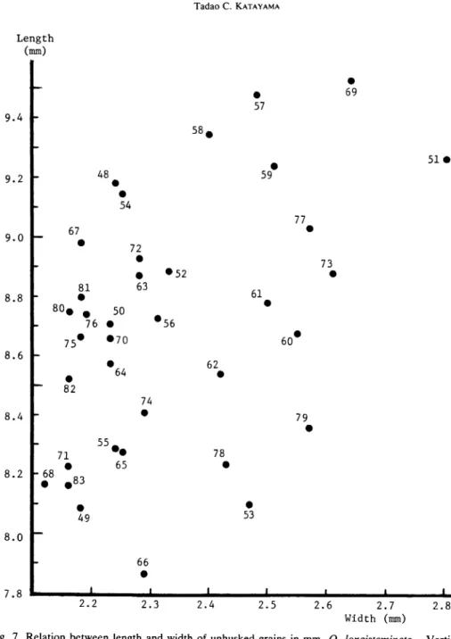
In comparison with two components, i.e., length and width of unhusked grains, the
following tendencies became clear, as illustrating in Fig. 7.
In this figure, the respective
strains were plotted in the respective values in both characters.
Four strains, i.e., W80 —W83, collected in Zanzibar and Pemba Islands, showed re latively narrow widths. Other four strains, i.e., W63 —W66, collected in Kigoma area,
Ifa-Length (mm) • • 57 69 9.4 58 • • 59 51 • 9.2 - 48 • • " 67 54 77 • 9.0 -• 81 72 • • 63 •52 73 • 8.8 - • 61 •
80# m
50#56
76 •75#
• 7060#
8.6 • 82 • 64 74 62 • 8.4 71 •55 ••
65 • 78 • 79 • 8.2 -6£ •.83
• 49 • 53 8.0 66 7.8 • i i i 2.2 2.3 2.4 2.5 2.6 2.7 Width (mm) 2.8Fig. 7. Relation between length and width of unhusked grains in mm, O. longistaminata. Vertical axis;
length, abscissa; width.
Code numbers used in the figure are corresponding to the collection
numbers used in Tables 1 and 2.
kara, and W69, collected in Ibada, showed very wide widths. It is noticed that the
value was very short in length of W66, collected in Uvinza.
Any other locality specifici
ty was not found at the present.
Thicknesses for the individual grain level ranged from 2.20 mm (W51), which was
the same as in case of the width, to 1.00 mm (W62).
In the strain level, the thickest
fol-lowed by W79 (1.75 mm), and W53, W57, W60 and W77 (1.72 mm).
The thinnest
(1.48 mm) was obtained in W49, followed by W82 (1.50 mm) and W83 (1.52 mm), in
which the latter two were the same as in case of the width.
Average and its standard
deviations in the whole strains were found to be 1.63 ±0.07.
In the standard deviations of each strain, the largest (0.18) was obtained in W51,
which was the same as in cases of the length and the width, followed by W61 and W62
(0.17).
The smallest (0.07) was noted in W55, W64 and W77.
Average and its stand
ard deviations in the whole strains were found to be 0.12±0.03.
Ratios of length to width (abbreviated as LAV in the table) for the individual grain
level ranged from 5.08 (W59) to 2.41 (W51).
In the strain level, the largest (4.13) was
obtained in W67, followed by W48 (4.12) and W54 (4.10).
The smallest (3.28) was
noted in W79, followed by W53 (3.29), which was the same as in case of the length, and
W51 (3.39).
Average and its standard deviations in the whole strains were found to be
3.77±0.24.
In the standard deviations of each strain, the largest (0.52) was obtained in W51,
which was the same as in cases of the length, width and thickness, and W56, followed by
W59 (0.51).
The smallest (0.23) was noted in W66, followed by W64 (0.25) and W82
(0.27).
Average and its standard deviations in the whole strains were found to be 0.38
±0.08.
Ratios of length to thickness (abbreviated as L/T in the table) for the individual
grain level ranged from 7.42 (W65) to 3.92 (W53).
In the strain level, the largest (5.86)
was obtained in W54, followed by W58 (5.75), which was the same as in case of the
length, and W82 (5.69).
The smallest (4.76) was noted in W53, followed by W79 (4.82)
and W78 (4.88).
Average and its standard deviations in the whole strains were found
tobe5.37±0.24.
In the standard deviations of each strain, the largest (0.76) was obtained in W62,
followed by W58 (0.71), and W59 and W65 (0.67). The smallest (0.32) was noted in
W70, followed by W48 (0.34) and W54 (0.35).
Average and its standard deviations in
the whole strains were found to be 0.48 ±0.11.Ratios of width to thickness (abbreviated as W/T in the table) for the individual
grain level ranged from 2.40 (W62) to 1.11 (W66, which was the same as in case of the
length, and W74).
In the strain level, the largest (1.63) was obtained in W73, followed
by W69 (1.57), which was the same as in case of the width, and W61 (1.53). The small
est (1.33) was noted in W67, followed by W48 (1.34), and W50, W68, W75, W76 and
W80 (1.35), in which the last one was the same as in case of the width.
Average and its
standard deviations in the whole strains were found to be 1.44±0.07.
In the standard deviations of each strain, the largest (0.26) was obtained in W62,
which was the same as in case of the ratio of length to thickness (L/T), followed by
W51, W58 and W61 (0.18), in which the last one was the same as in case of the
the same as in case of the width, followed by W60 and W77 (0.10).
Average and its
standard deviations in the whole strains were found to be 0.14±0.03.II.
Oryza punctata (Collection Nos.W84~W109)
The results are given in Table 3.
Lengths for the individual grain level ranged from 7.40 mm (W91) to 4.80 mm
(W100 and W106).
In the strain level, the longest (6.42 mm) was obtained in W91, fol
lowed by W93 (6.36 mm), and W92 and W102 (6.33 mm).
The shortest (5.51 mm) was
noted in W90, followed by W106 (5.52 mm) and W105 (5.67 mm).
Average and its
standard deviations in the whole strains were found to be 5.96±0.25.
In the standard deviations of each strain, i.e., those showing intra-population's
variations, the largest (0.56) was obtained in W91, followed by W94 (0.53) and W93
(0.48).
The smallest (0.28) was noted in W84 and W98, followed by W85 (0.31).
Average and its standard deviations in the whole strains were found to be 0.40±0.07.
Widths for the individual grain level ranged from 2.80 mm (W85 and W98) to 1.70
Table 3.
Six morphological characters of unhusked grains of Tanzania, O. punctata
Collec tion No. Acces sion No. Length (mm) Width (mm) Thickness (mm) L/W L/T W/T W84 2084 5.90±0.28 2.28±0.11 1.48 ±0.09 2.59±0.20 4.01 ±0.32 1.55±0.11 W85 2085 6.16±0.31 2.43±0.16 1.61 ±0.08 2.55±0.21 3.82±0.22 1.51±0.13 W86 2086 5.94±0.43 2.26±0.14 1.51 ±0.08 2.63±0.27 3.95±0.41 1.50±0.10 W87 2087 6.08±0.45 2.38±0.19 1.59±0.06 2.58±0.31 3.84±0.35 1.50±0.13 W88 2088 6.05 ±0.46 2.35±0.20 1.60 ±0.09 2.60±0.31 3.79±0.33 1.47±0.11 W89 2089 5.93 ±0.42 2.04±0.17 1.45 ±0.09 2.93±0.36 4.09±0.36 1.41±0.12 W90 2090 5.51 ±0.35 2.12±0.14 1.43 ±0.08 2.61 ±0.22 3.86±0.31 1.48±0.11 W91 2091 6.42±0.56 2.18±0.17 1.50±0.10 2.96±0.35 4.29±0.45 1.46±0.15 W92 2092 6.33±0.37 2.20±0.19 1.50±0.10 2.90±0.32 4.24 ±0.43 1.47±0.17 W93 2093 6.36±0.48 2.22±0.17 1.50±0.12 2.89±0.33 4.27±0.47 1.48±0.15 W94 2094 6.25±0.53 2.28±0.19 1.47 ±0.09 2.76±0.33 4.25±0.33 1.56±0.17 W95 2095 6.01 ±0.45 2.20±0.19 1.59±0.06 2.76±0.36 3.79±0.30 1.39±0.13 W96 2096 5.75±0.39 2.27±0.18 1.53±0.08 2.55±0.22 3.77±0.27 1.49±0.14 W97 2097 5.78±0.34 2.21±0.16 1.48 ±0.07 2.63 ±0.26 3.92±0.32 1.50±0.14 W98 2098 6.17±0.28 2.52±0.12 1.61 ±0.08 2.46±0.17 3.84±0.25 1.57±0.12 W99 2099 5.72±0.41 2.33±0.19 1.55±0.06 2.48±0.31 3.71±0.37 1.51±0.12 W100 2100 5.82±0.44 2.30±0.16 1.52 ±0.09 2.55±0.33 3.86±0.35 1.53±0.17 WlOl 2101 6.02±0.35 2.37±0.12 1.50±0.07 2.54±0.13 4.03±0.33 1.59±0.12 W102 2102 6.33±0.37 2.52±0.13 1.44 ±0.09 2.52±0.18 4.42±0.33 1.76±0.15 W103 2103 5.91 ±0.36 2.40±0.13 1.46 ±0.08 2.47±0.12 4.05±0.33 1.64±0.11 W104 2104 6.05 ±0.38 2.32±0.17 1.46 ±0.06 2.63 ±0.28 4.15±0.32 1.59±0.14 W105 2105 5.67±0.33 2.16±0.16 1.43 ±0.08 2.64 ±0.27 3.97±0.31 1.51±0.15 W106 2106 5.52±0.38 2.31±0.14 1.52±0.10 2.39±0.17 3.65 ±0.30 1.53±0.11 W107 2107 5.85±0.37 2.29±0.16 1.57±0.08 2.56±0.19 3.73±0.30 1.46±0.13 W108 2108 5.85±0.42 2.29±0.21 1.51+0.10 2.59±0.41 3.89±0.32 1.52±0.16 W109 2109 5.68±0.37 2.38±0.12 1.48±0.10 2.39±0.18 _3_._87±q.32 1.62±0.15 "Whole"Average T.~96±0.~25~""~2.29±0~.lT~"T.5T±0.05~""'"2.62±6".15"""T.96±0."20" '"l.52±6"07"""
mm (W89).
In the strain level, the widest (2.52 mm) was obtained in W98 and W102,
followed by W85 (2.43 mm).
The narrowest (2.04 mm) was noted in W89, followed by
W90 (2.12 mm) and W105 (2.16 mm).
Average and its standard deviations in the
whole strains were found to be 2.29±0.11.
In the standard deviations of each strain, the largest (0.21) was obtained in W108,
followed by W88 (0.20), and W87, W92, W94, W95 and W99 (0.19).
The smallest
(0.11) was noted in W84, which was the same as in case of the length, followed by W98,
WlOl and W109 (0.12), in which the first one was the same as in case of the length.
Average and its standard deviations in the whole strains were found to be 0.16±0.03.
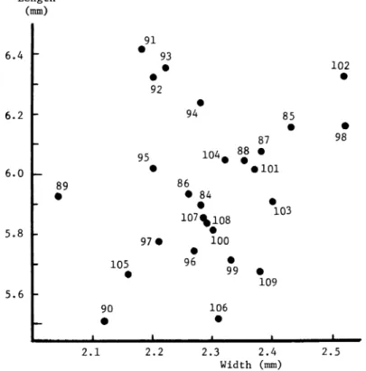
In comparison with two components, i.e., length and width of unhusked grains, the
following tendencies became clear, as illustrating in Fig. 8.
In this figure, the respective
strains were plotted in the respective values in both characters.
One strain, i.e., W89, collected near Uvinza, showed particularly narrow in width.
Five strains, i.e., W90~ W94, collected in eastern area of Mwanza, showed relatively
narrow in width.
In these strains, four strains except W90, showed very long lengths.
Two strains, i.e., W98 and W102, collected in Zanzibar, showed particularly very wide
Length (mm) 91 6.4
#
93
• • 92 • 102 • 6.2 95 94104# 8g
85 • 87 • • 98 6.0 89 • • 86 • 84 • 101 • •107^108
103 5.8 97 • • 100 • 105 96 • • 99 • 109 5.6 90 • 106 • 2.1 2.2 2.3 2.4 Width (mm) 2.5Fig. 8. Relation between length and width of unhusked grains in mm, O. punctata. Vertical axis; length, abscissa; width. Code numbers used in the figure are corresponding to the collection numbers used in Tables 1 and 3.
in width and very long in length.
Any other locality specificity was not found at the present.
Thicknesses for the individual grain level ranged from 1.80 mm (W93) to 1.30 mm
(W86, W89, which was the same as in case of the width, W90, W93, W94, W102, W103
and W105).
In the strain level, the thickest (1.61 mm) was obtained in W85 and W98,
in which the latter was the same as in case of the width, followed by W88 (1.60 mm).
Thinnest (1.43 mm) was noted in W90, which was the same as in case of the length, and
W105, followed by W102 (1.44 mm).
Average and its standard deviations in the whole
strains were found to be 1.51 ±0.05.
In the standard deviations of each strain, the largest (0.12) was obtained in W93,
followed by W91, W92, W106, W108 and W109 (0.10).
The smallest (0.06) was noted
in W87, W95, W99 and W104.
Average and its standard deviations in the whole strains
were found to be 0.08±0.01.
Ratios of length to width (abbreviated as L/W in the table) for the individual grain
level ranged from 3.70 (W91), which was the same as in case of the length, to 1.93
(W87).
In the strain level, the largest (2.96) was obtained in W91, which was the same
as in case of the length, followed by W89 (2.93) and W92 (2.90).
The smallest (2.39)
was noted in W106 and W109, followed by W98 (2.46).
Average and its standard de
viations in the whole strains were found to be 2.62±0.15.
In the standard deviations of each strain, the largest (0.41) was obtained in W108,
which was the same as in case of the width, followed by W89 and W95 (0.36). The
smallest (0.12) was noted in W103, followed by WlOl (0.13), which was the same as in
case of the width, and W98 and W106 (0.17).
Average and its standard deviations in
the whole strains were found to be 0.26 ±0.08.
Ratios of length to thickness (abbreviated as L/T in the table) for the individual
grain level ranged from 5.46 (W93), which was the same as in case of the thickness, to
3.00 (W99, W100 and W108), in which the middle one was the same as in case of the
length.
In the strain level, the largest (4.42) was obtained in W102, which was the same
as in case of the width, followed by W91 (4.29) and W93 (4.27). The smallest (3.65)
was noted in W106, which was the same as in case of the ratio of length to width (L/W),
followed by W99 (3.71) and W107 (3.73).
Average and its standard deviations in the
whole strains were found to be 3.96±0.20.In the standard deviations of each strain, the largest (0.47) was obtained in W93,
followed by W91 (0.45) and W92 (0.43). The smallest (0.22) was noted in W85, fol
lowed by W98 (0.25), which was the same as in cases of the width and the ratio of
length to width (L/W), and W96 (0.27).
Average and its standard deviations in the
whole strains were found to be 0.33 ±0.06.Ratios of width to thickness (abbreviated as W/T in the table) for the grain level
in cases of the length and the ratio of length to thickness (L/T).
In the strain level, the
largest (1.76) was obtained in W102, which was the same as in cases of the width and
the ratio of length to thickness (L/T), followed by W103 (1.64) and W109 (1.62).
The
smallest (1.39) was noted in W95, followed by W89 (1.41), and W91 and W107 (1.46).
Average and its standard deviations in the whole strains were found to be 1.52 ±0.07.
In the standard deviations of each strain, the largest (0.17) was obtained in W92,
W94 and W100.
The first one was the same as in case of the thickness.
The smallest
(0.10) was noted in W86, followed by W84, W88, W90, W103 and W106 (0.11).
Average and its standard deviations in the whole strains were found to be 0.13 ±0.02.
Summary
During the trip from July to August in 1988 in Tanzania, 62 strains of wild rice spe
cies, i.e., 36 of Oryza longistaminata Chev. et ROEHR., and 26 of Oryza punctata KOTS
CHY, were collected, and many populations of them were observed.
Their localities and
habitats were reported in detail.
Main locality names are as follows; Kibaha, Ifakara,
Kyela, Ihahi, Mbarari, Shelui, Dodoma, Nzega, Kahama, Kigoma, Ujiji, Uvinza, Kasu
lu, Ibada, Mwanza, Mtwango, Kilombero, Bumbwi, Kasole, Kibirinzi, Ole. They have
a creeping growth in pond, swamp, embankment, irrigation canal and small stream.
From the analyses of unhusked grains, average values and the standard deviations
of O. longistaminata in the whole strains were found to be 8.70 mm ±0.41, 2.34 mm±
0.17, 1.63 mm±0.07, 3.77±0.24, 5.37±0.24 and 1.44±0.07 in length, width, thickness,
ratios of length to width, of length to thickness and of width to thickness, respectively.
In O. punctata, average values and those standard deviations in the whole strains were
found to be 5.96 mm±0.25, 2.29 mm±0.11, 1.51 mm±0.05, 2.62±0.15, 3.96±0.20 and
1.52 ±0.07 in the same order, respectively.
It may be noticeable that the populations of
W51, collected in Mahutansa, Ifakara, and W69, collected in Ibada, showed very large
values both in length and width.
Moreover, populations of W98 and W102 collected in
Zanzibar showed particularly larger values both in length and width.
In the analyses of the data obtained in the field surveies, morphological and
geneti-cal characters, ecotypic and varietal differentiations could be discussed in the future.
References

![Fig. 2. Sketch maps (1) of habitats of wild rice population. Circle dot [•] shows wild rice, Oryza lon gistaminata Chev](https://thumb-ap.123doks.com/thumbv2/123deta/6407414.1107671/13.756.106.640.308.926/sketch-habitats-population-circle-shows-oryza-gistaminata-chev.webp)
![Fig. 3. Sketch maps (2) of habitats of wild rice population. Circle dot [• ] and square mark [•] show Oryza longistaminata Chev](https://thumb-ap.123doks.com/thumbv2/123deta/6407414.1107671/14.750.125.648.139.778/sketch-habitats-population-circle-square-oryza-longistaminata-chev.webp)
![Fig. 4. Sketch maps (3) of habitats of wild rice population. Circle dot [• ] and square mark [•] show Oryza longistaminata Chev](https://thumb-ap.123doks.com/thumbv2/123deta/6407414.1107671/15.757.89.631.137.784/sketch-habitats-population-circle-square-oryza-longistaminata-chev.webp)
![Fig. 5. Sketch maps (4) of habitats of wild rice population. Circle dot [•] and square mark [•] show Oryza longistaminata Chev](https://thumb-ap.123doks.com/thumbv2/123deta/6407414.1107671/16.754.141.663.127.779/sketch-habitats-population-circle-square-oryza-longistaminata-chev.webp)
![Fig. 6. Sketch maps (5) of habitats of wild rice population. Circle dot [• ]and square mark [•] show Oryza longistaminata Chev](https://thumb-ap.123doks.com/thumbv2/123deta/6407414.1107671/17.757.102.632.148.785/sketch-habitats-population-circle-square-oryza-longistaminata-chev.webp)