Title
2015年ネパールゴルカ地震の建物被害調査と常時微動計
測
Author(s)
山田, 真澄; 林田, 拓己; MORI, Jim; MOONEY, Walter
Citation
京都大学防災研究所年報. A = Disaster Prevention Research
Institute Annuals. A (2016), 59(A): 65-73
Issue Date
2016-06
URL
http://hdl.handle.net/2433/217265
Right
Type
Departmental Bulletin Paper
2015年ネパールゴルカ地震の
建物被害調査と常時微動計測
Building Damage Survey and Microtremor Measurements
for the Source Region of the 2015 Gorkha, Nepal Earthquake
山田真澄・林田拓己
(1)・Jim MORI・Walter MOONEY
(2)Masumi YAMADA, Takumi HAYASHIDA
(1), Jim MORI and Walter MOONEY
(2)(1) 建築研究所 (2) アメリカ地質調査所
(1) Building Research Institute, Japan
(2) United States Geological Survey, US
Synopsis
We performed a damage survey of buildings and carried out microtremor observations
in the source region of the 2015 Gorkha eathquake. Our survey area spans the
Kathmandu valley, and areas to the east and north of the valley. Damage of buildings in
the Kathmandu valley was localized, and the percentage of the totally collapsed
buildings was less than 5%. East of the Kathmandu valley, especially in Sindhupalchok
district, damage of buildings was more severe. In the center of Chautara and Bahrabise,
towns in Sindhupalchok district, the percentage of the totally collapsed houses exceeded
40%. North of the Kathmandu valley, the damage was moderate, and 20 to 30% of the
buildings were totally collapsed in Dhunche.
Based on the past studies and our microtremor observations near the strong motion
station, the H/V spectrum in Kathmandu has a peak at around 0.3 Hz, which reflects the
velocity contrast of the deep sedimentary basin. The H/V spectra in Chautara, Bahrabise,
and Dhunche do not show clear peaks, which suggests that the sites have stiff soil
conditions. Therefore, the more severe damage outside the Kathmandu valley compared
to the relatively light damage levels in the valley, is probably due to the source
characteristics of the earthquake and/or the seismic performance of buildings, rather
than the local site conditions.
キーワード
: 2015年ネパールゴルカ地震,組積造,地震被害,強震動,常時微動計測Keywords: 2015 Gorkha earthquake, Masonry structure, Earthquake damage, Strong
motion, Microtremor survey
1.
はじめに
2015年ネパールゴルカ地震は2015年4月25日に発 生し,首都のカトマンズを含む広い地域に大きな被
害をもたらした.死者は約9000人,負傷者は22000
以上である(The Ministry of Home Affairs, 2015).この
地震は,1934年のビハール・ネパール地震以来,ネ
パールにおいて最悪の自然災害であった(Piya, 2014).
京都大学防災研究所年報 第 59 号 A 平成 28 年 6 月 Annuals of Disas. Prev. Res. Inst., Kyoto Univ., No. 59 A, 2016
地震発生当時,ネパール国内には数点の地震観測点 しか設置されておらず,得られた強震記録は限られ
ている(例えば,Center for Engineering Strong Motion
Data, 2015; Bhattarai et al., 2015; Dixit et al., 2015; Takai et al., 2016)ので,波形記録のみから地震被害 や地震動の全貌を明らかにすることは困難である. 我々は,カトマンズ盆地とその周辺で建物被害調 査を行い,震源域での建物被害を調べた.また,被 害調査を行った各地で常時微動計測を行い,被害に 与える地盤増幅の影響について調べたので報告する.
2. 地震と強震動
ゴルカ地震はUTC時間で4月25日6時11分25秒 (現 地時間11時56分25秒)に発生し,モーメントマグニチ ュードは7.8であった(USGS, 2015).推定された最大 メルカリ震度はIXである(USGS, 2015).震源位置は カトマンズ市の北西80kmのゴルカ地方で,震源の深 さは約10kmである(USGS, 2015).地震波形インバー ジョンの結果によれば,最大滑りの位置は震源地か ら約80km東側で,カトマンズ市の北側と推定される(Galetzka et al., 2015; Yagi and Okuwaki 2015; Fan and Shearer 2015; USGS, 2015; Wang and Fialko 2015; He et al., 2015).
カトマンズ市内のUSGSのKATNP観測点において
観測された本震の強震波形をFig. 1に示す.地震計は
加速度で記録しており,DCオフセットを取り除いて
時刻歴で一階積分することによって速度記録を求め
た(Iwan, 1985; Boore 2001).最大速度はEW成分で
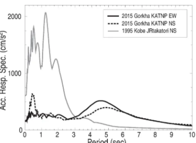
100cm/sを超えている.地震動の卓越周期は約5秒で ある(Fig. 2参照).日本国内で甚大な建物被害をもた らした強震記録の例として,1995年兵庫県南部地震 の鷹取の強震記録をFig. 2に合わせて示す.この記録 は卓越周期が約1-2秒であり,これに比べるとKATNP の強震記録の卓越周期は約5秒と非常に長くなって いる. この周期の長い地震動の生成原因はカトマンズ盆 地の共振である可能性が高いことが報告されている (Galetzka et al., 2015).長周期成分は非常に大きいが, 1-2秒のより短周期の成分は比較的小さく,最大加速 度の最大値はUD成分で182 cm/s2に留まっている.
Fig. 1 Strong motion record of the mainshock recorded at the USGS KNTNP station in Kathmandu. Top: acceleration waveforms, bottom: velocity waveforms.
3. 現地調査
我々は2015年9月18-24日の期間に現地において組 積造建物の被害調査と常時微動計測を行った.調査 範囲はカトマンズ盆地内と盆地の北側と東側で,そ れぞれの地域の大規模な町において建物の被害レベ ルの分類を行った.調査を行った町は,カトマンズ盆 地 の 中 で は , Kathmandu, Bhaktapur, Patan,
Changunarayan, Nagadesh, Piker, 盆 地 の 東 側 で は Banepa, Chautara, Khadichaur, Bahrabise, 盆地の北側
ではBidur, Betrawati, Duncheである.Fig. 3に調査した
Fig.2 Comparison of acceleration response spectra. The USGS data recorded in Kathmandu KATNP station and the JR Takatori record for the 1995 Kobe earthquake (all measurements have a 5% damping coefficient).
3.1 組積造建物の被害調査
建物の全壊率を求めるために,各地点において組 積造建物の被害レベルを調査した.組積造建物は, コンクリート枠組で補強されたものと補強されてい ないものを含んでいる.被害レベルは構造体への被 害の度合いに応じてD1-D4の4段階で分類した(Fig.4 参照).D1の建物の被害は,壁の小さなひび割れや表 面の外装材の剥落などの非構造部材の被害が中心で, 小規模の構造部材の被害を含むこともある.D2の建 物は構造部材に中規模の被害を含んでおり,壁の破 壊や柱梁部材のひび割れなど,耐震性を保つために 補強が必要となるものである.D3の建物は,建物が 傾く等構造部材に大きな被害を受けており,使用を 続けることが危険である.D4建物は完全に層崩壊し ているか,調査時にはすでに片づけられていた建物 である.本研究では,D2の建物を半壊,D3とD4の建 物を全壊と定義した.日本の被害調査で良く使われ る ヨ ー ロ ッ パ の 被 害 基 準(EMS-98)と比較すると, 我々のD3はグレード4と対応し,D4はグレード5に対 応する.Fig. 3 Summary of the damage survey and a source model. (a) Damage percentage of totally collapsed buildings at the sites we visited (squares), and sites visually inspected from the vehicle (circles). The large and small star shows the epicenter of the mainshock and aftershock on May 12, respectively. The background color indicates the fatalities in each district. (b) Source model (Fig 1A of Galetzka et al. (2015) was revised). The area is the same with Figure 3(a).
我々は調査対象の中で規模の大きい町において 1-2時間,50から100棟の組積造建物の被害分類を行
った.選択した建物は,それぞれの町の中心部の大 通り沿いに位置する.カトマンズ盆地の外側の都市
(バラビセ・チョータラ・ドゥンチェ)は比較的規 模が小さく,中心部のほとんどの建物を見ることが できた.調査に参加した4人の間で,写真や観察した 被害の程度を共有し,結果に大きな認識の差がない ことを確認している. これまでの調査結果では,古い歴史的建物に被害 が集中していることが報告されているが(例えば, Goda, 2015),我々は整合性を保つために,通常の住 宅や店舗などの建物に対象を限定している.調査地 点への移動途中で,車中から観察した町の被害の程 度についても記録している.これらの観察結果は実 際に歩いて記録した被害率と比較すると精度が良く ないことは当然であるが,限られた情報を少しでも 共有するために,Fig 3(a)に小さい丸印で示している.
3.2 常時微動計測
常時微動計測は,地震被害と地盤増幅の関係を調 べるために利用されてきた(例えば,Chatelain et al., 2008; Hellel et al., 2010; Yamada et al., 2014).我々も 各地点で表層地盤増幅を評価するために,常時微動 計測 を実 施し た. 常時 微動 計測 には 白山 工業 製の JU210を利用した.JU210は3成分加速度計,データロ ガー,バッテリーが1つのケーシングに内蔵されてお り, 携帯 性に 優れ てい る. サン プリ ング 周波 数は 100Hzで,エイリアシングを防ぐために30Hzのハイ カットフィルターを適用している.それぞれの町で 代表的な2-3地点で計測を行い,5~30分間程度計測 した. 常時指導計測記録から,各地点でのH/Vスペクトル (Nakamura 1989)を以下の方法により計算した.まず, 4096サンプル(40.96秒)のセグメントをランダムに5 区間切り出し,各セグメントのフーリエ振幅スペク トルを計算する.スペクトルにスムージングフィル タ(0.05Hzの幅のパルツェンウィンドウ)をかけた あと,各水平成分スペクトルを鉛直成スペクトルで 割った.切り出しセグメントをランダムに変えてこ の処理を100回繰り返し,もっとも分散の小さくなる 5つのスペクトルを選択した.最後に,2つの水平成 分の平均をとってH/Vスペクトルを求めている.4. 調査結果
4.1 建物被害
それぞれの町での全壊建物被害率を図3(a)に示す. カトマンズ盆地での建物被害は一部の地域に集中し ており(バクタプール,サンクー,カトマンズ市の バスターミナル付近) ,盆地全体での被害率は5% 以下である(ネパール地質調査所(DMG) からの情報 による).カトマンズ盆地の東側,特にシンドゥー パルチョーク郡では,建物被害が大きくなっている. チョ ータ ラと バラ ビセ では ,全 壊建 物の 被害 率は 40%を超えている.また,移動途中にも全壊建物の 集中した小さな町がいくつか観察された.カトマン ズ盆地の北側では,被害の規模は中程度であり,ベ ト ラ ワ テ ィ と ド ゥ ン チ ェ で は 全 壊 建 物 被 害 率 は 20-30%である. Fig. 3(a) には各郡での死者数を背景色で示してい る(The Ministry of Home Affairs, 2015).被害の大きか った町の分布は,人的被害の分布とよく対応してい る.最も死者数の多かったのはシンドゥーパルチョー ク 郡 で あ り ,3000人以上 が亡くな って いる(The
Ministry of Home Affairs, 2015).我々の調査でも,郡 内の2つの町(チョータラとバラビセ)は40%以上の 倒壊率という非常に大きな被害を受けていた.これ らの結果から,多くの人が建物の倒壊によって亡く なったことを示唆している. 次に,4つの中心都市(カトマンズ,バラビセ,チ ョータラ,ドゥンチェ)に限定し,都市の特徴,建 物の種類,被害について記述する(Fig. 5と6参照). カトマンズ:ネパールの首都であり,人口は約100 万人である.中心部には現代的なコンクリートの中 層建物も存在するが,建物のほとんどは低層の煉瓦 の組積造建物である.USGSの強震記録は,タメル地 区にある元大使館建物の屋内に設置されている.観 測点の周りには全壊の建物は我々の調査では見つか らなかった. バラビセ:カトマンズの60kmほど東北東に位置する 町で,シンドゥーパルチョーク郡に属する.カトマ ンズと中国との国境を結ぶアラニコ幹線道路沿いに ある.町はこの幹線道路と並行して流れるスンコシ 川に沿って形成されている.この町には石積みの組 積造建物も多く見られた.これらの建物は,粗石を 積み上げて石膏で表面を固め,時には表面に煉瓦の
ような格子模様を施している(EERI and IAEE, 2015).
我々の調査結果では,全壊率は42%で,半壊率が11% であった. チョータラ:カトマンズの40kmほど東北東に位置す る町で,シンドゥーパルチョーク郡の郡都である. 山岳地帯の中に存在する町で,標高は約1600mであ る.建物のほとんどは組積造で,地震で大きな被害 を受けた.我々の被害調査では,46%の建物が全壊 し,16%が半壊していた.一部の建物はすべて煉瓦 で作られており,コンクリート枠組と煉瓦の壁で作 られた補強された組積造の建物も存在した.
Fig. 4 Photo of buildings with damage levels D2-D4. (a) D2: plasters on the column was fallen down. (b) D3: permanent drift was observed. (c) D4: almost all infil was fallen down.
ドゥンチェ:この町はカトマンズの50kmほど北側に 位置し,ラスワ郡の郡都である.この町はランタン 国立公園の中に存在し,宿泊施設やお土産屋が多く, 地震の前はハイカーでにぎわった町であった.高度 は約2000mである.カトマンズとドゥンチェを結ぶ 幹線道路は地震によって引き起こされた地滑りで大 きな被害を受けた.我々の調査結果では,全壊率が 27%,半壊率が25%であった.建物のほとんどは煉 瓦の組積造であった(EERI and IAEE, 2015).
4.2 常時微動計測結果
Fig. 6 はカトマンズ,バラビセ,チョータラ,ド ゥンチェで計測した常時微動のH/Vスペクトルを示 している.カトマンズでの計測場所はUSGSの共振観 測点の近傍で,他は町の中心部である.被害調査を した地域の中の狭い範囲で,複数の地点で常時微動 計測を行ったが,概ね計測結果は整合していた. カトマンズのH/Vスペクトルは,ピークが0.3Hzの あたりに見られる.このピーク周波数は過去の研究 成果とも一致しており(Paudyal et al., 2012, 2013),カ トマンズ盆地の深い堆積地盤と基盤との速度コント ラストを反映していると考えられる.この低い固有 振動数はゴルカ地震で観測された長周期の地震波形 (0.2Hz)と整合的である.微動から計測された卓越 振動数と強震記録の卓越振動数には差があるが,強 震時には地盤が非線形化して周期が長くなることを 考慮すれば矛盾しない. バラビセ,チョータラ,ドゥンチェで計測された H/Vスペクトルには明瞭なピークが見られない.この ことは,これらの地点での浅部地盤構造に強い速度 コントラストが存在しないことを示唆している.こ れらの地域は山岳地帯にあるため,地盤構造は堅固 で 表 層 地 盤 増 幅 の 影 響 は 小 さ い と 考 え て い る (Bonnefoy-Claudet et al., 2009).5. 議論
我々の現地調査の結果からは,カトマンズ盆地内 の被害は相対的に少なく,より大きな被害が盆地の 東側に確認できた.震源近傍のGPS記録や遠地地震 波形記録から推定された震源モデルによると,最大 すべりはカトマンズの20-30km北側に位置する.この すべりから生成された長周期パルスはカトマンズ盆 地と共振して過渡応答し,周期5秒の長周期地震動を 生み出した.しかしながら,この地震動は低層の組 積造建物に被害を及ぼすには周期が長すぎたため, カトマンズ盆地内の壊滅的な被害は免れたと考えら れる.我々はいくつかの組積造建物で常時微動計測 を行ったが,2階建ての建物の固有周期は3-4Hzであ った.観測された長周期の地震動は,もしカトマン ズ盆地に超高層建物が存在した場合には,大きな被 害をもたらしたと考えられる. カトマンズ盆地の東側での大被害の生成要因はよ り複雑である.構造物の多くは低層組積造建物なの で,建物の固有周波数は数Hzと考えられる.したが って,このような低層建物に大きな被害をもたらし たのは,より高周波成分の地震動が大きかったため と考えられる.震源断層は東から北に向かって破壊 しており(Galetzka et al., 2015),これらの町は最大す べ り か ら 破 壊 が 進 む 方 向 に 位 置 し て い る た め(Fig. 3(b)参照),破壊の指向性も東側の地域での強い地震 動に影響したと推測される. 構造物の耐震性能の違いも異なる被害の生成要因 の一つであると考えられる.多くの建物は組積造で あるものの,材料には様々な違いがあり,煉瓦,コ ンクリートブロック,石などが使われている.また 連 結 素 材 に も セ メ ン ト や 土 な ど 違 い が 見 ら れ る (Bhattarai and Conway, 2010; Shrestha et al., 2012).コ ンクリート骨組による補強建物の割合も被害率に影 響すると考えられる.バラビセとチョータラの常時 微動の結果からは,表層地盤増幅の影響は小さく, 少なくともそれが大被害の主要因ではないことを示 している. 我々の被害調査は2015年5月12日に発生したM7.3 の最大余震の後に行われているため,この余震と本 震によって生じた被害を区別することは困難である. 少なくともUSGSの地震動マップではほとんどの地 域で本震の地震動は最大余震よりも大きく推定され ている.また,現地住民へのインタビューにより, ほとんどの被害は4月25日の本震によってもたらさ れたことを確認している.しかしながら,5月12日の 余震の震源地に近い最も東側の町(バラビセなど) では,余震で被害が増加した可能性があることに注 意する必要がある.Fig. 6 Location of mictotremor measurements and H/V spectra in each town.
Left: Map of the surveyed area (white painted area) and location of H/V measurements (yellow circles). Google Earth was used to make maps. Right: H/V spectra measured at the location.
6. 結論
我々は2015年ネパールゴルカ地震の地震動と被害 の分布を推定するために,カトマンズ盆地の内部と 周 辺 で 建 物 被 害 調 査 と 常 時 微 動 計 測 を 行 っ た (Yamada et al., 2016). カトマンズ盆地内での被害は分布の不均一性が見 られるが,全体として盆地内の倒壊率は5%以下であ る.一方,カトマンズ盆地の外側では,特に東側の 地域において建物被害は深刻であり,バラビセとチ ョータラでは40%以上の建物が倒壊していた.我々 の調査は時間と空間分解能に限界があり,被害の全 貌を把握するためにはより詳細な調査が必要である. 既往の研究と常時微動計測の結果から,カトマン ズの強震観測点付近のH/Vスペクトルの卓越振動数 は約0.3Hzであり,カトマンズ盆地の深い堆積地盤構 造の速度コントラストを反映していると考えられる. 建物被害が深刻であったバラビセ,チョータラ,ド ゥンチェのH/Vスペクトルには明確なピークが見ら れず,表層地盤が固いか明確な速度コントラストが ないと推測される.したがって,カトマンズ盆地の 外側のより大きな被害は,表層地盤構造の影響より も,震源特性の違いによる地震動の違いか,建物の 耐震性能によってもたらされた可能性が高い.謝 辞
National Society for Earthquake Technology - Nepal(NSET)の Amod Mani Dixit博士には貴重なデー タを提供していただきました.またネパール地質調
査 所(DMG) の Soma Nath Sapkota 博 士 , Lok Bijaya
Adhikari博士,Mukunda Bhattarai博士には大変意義の
ある議論をさせていただきました. 現地調査はJST
のJ-RAPID研究費の支援を受けて実施しました.強震
動記録はthe Center for Engineering Strong Motion Data
にて提供されているものを使用しました.ここに記 して謝意を表します.
参考文献
Bhattarai, K. and Conway, D. (2010): Urban vulnerabilities in the Kathmandu valley, Nepal: visualizations of human/hazard interactions. Journal of Geographic Information System, 2(02): pp.63-84. Bhattarai, M., Adhikari, L. B., Gautam, U. P.,
Laurendeau, A., Labonne, C., Hoste-Colomer, R., Sbe, O., and Hernandez, B. (2015): Overview of the large 25 april 2015 Gorkha, Nepal, earthquake from accelerometric perspectives. Seismol. Res. Lett., 86(6):
pp.1540-1548.
Bonnefoy-Claudet, S., Baize, S., Bonilla, L. F., Berge-Thierry, C., Pasten, C., Campos, J., Volant, P., and Verdugo, R. (2009): Site effect evaluation in the basin of Santiago de Chile using ambient noise measurements. Geophys. J. Int., 176(3): pp.925-937. Boore, D. M. (2001): Effect of baseline corrections on
displacements and response spectra for several recordings of the 1999 Chi-Chi, Taiwan, earthquake. Bull. Seismol. Soc. Am., 91(5): pp.1199-1211.
Center for Engineering Strong Motion Data (2015): http://strongmotioncenter.org/. Accessed 10 October 2015.
Chatelain, J.-L., Guillier, B., and Parvez, I. A. (2008): False site effects: The Anjar case, following the 2001 Bhuj (India) earthquake. Seismol. Res. Lett., 79(6): pp.816-819.
Dixit, A. M., Ringler, A. T., Sumy, D. F., Cochran, E. S., Hough, S. E., Martin, S. S., Gibbons, S., Luetgert, J. H., Galetzka, J., and Shrestha, S. N. (2015): Strong-motion observations of the M 7.8 Gorkha, Nepal, earthquake sequence and development of the n-shake strong-motion network. Seismol. Res. Lett., 86(6): pp.1533-1539.
EERI and IAEE. World Housing Encyclopedia, Pillar walaghar (URM infilled RC frame buildings), http://db.world-housing.net/building/145. Accessed 1 December 2015.
EERI and IAEE. World Housing Encyclopedia, uncoarsed rubble stone masonry walls with timber floor and roof, http://db.world-housing.net/building/74. Accessed 1 December 2015.
Fan, W. and Shearer, P. M. (2015): Detailed rupture imaging of the 25 April 2015 Nepal earthquake using teleseismic p Waves. Geophys. Res. Lett., 42(14): pp.5744-5752.
Galetzka, J., Melgar, D., Genrich, J. F., Geng, J., Owen, S., Lindsey, E. O., Xu, X., Bock, Y., Avouac, J.-P., and Adhikari, L. B. (2015): Slip pulse and resonance of the Kathmandu basin during the 2015 Gorkha earthquake, Nepal. Science, 349(6252): pp.1091-1095.
Goda, K., Kiyota, T., Pokhrel, R. M., Chiaro, G., Katagiri, T., Sharma, K., and Wilkinson, S. (2015): The 2015 Gorkha Nepal earthquake: Insights from earthquake damage survey. Frontiers in Built Environment, 1.
He, X., Ni, S., Ye, L., Lay, T., Liu, Q., and Koper, K. D. (2015): Rapid seismological quantification of source parameters of the 25 April 2015 Nepal earthquake.
Seismol. Res. Lett., 86(6): pp.1568-1577.
Hellel, M., Chatelain, J.-L., Guillier, B., Machane, D., Salem, R. B., Oubaiche, E. H., and Haddoum, H. (2010): Heavier damages without site effects and site effects with lighter damages: Boumerdes city (Algeria) after the May 2003 earthquake. Seismol. Res. Lett., 81(1): pp.37-43.
Iwan, W. D., Moser, M. A., and Peng, C.-Y. (1985): Some observations on strong-motion earthquake measurement using a digital accelerograph. Bull. Seismol. Soc. Am., 75(5): pp.1225-1246.
Nakamura, Y. (1989): A method for dynamic characteristics estimation of subsurface using microtremor on the ground surface. Railway Technical Research Institute, Quarterly Reports, 30(1).
Paudyal, Y. R., Yatabe, R., Bhandary, N., and Dahal, R. (2012): A study of local amplification effect of soil layers on ground motion in the Kathmandu valley using microtremor analysis. Earthquake Engineering and Engineering Vibration, 11(2): pp.257-268.
Paudyal, Y. R., Yatabe, R., Bhandary, N. P., and Dahal, R. K. (2013): Basement topography of the Kathmandu basin using microtremor observation. J. Asian Earth Sci., 62: pp.627-637.
Piya, B. (2004): Generation of geological database for liquefaction hazard assessment in Kathmandu Valley. PhD thesis, International Institute for Geo-information Science and Earth Observation, Enschede, Netherlands. Sakai, H., Fujii, R., and Kuwahara, Y. (2002): Changes
in the depositional system of the Paleo-Kathmandu lake caused by uplift of the Nepal Lesser Himalayas. J. Asian Earth Sci., 20(3): pp.267-276.
Shrestha, H., Pradhan, S., and Guragain, R. (2012): Experiences on retrofitting of low strength masonry buildings by different retrofitting techniques in Nepal. In 15th World Conference on Earthquake Engineering,
Lisbon, Portugal.
Takai, N., Shigefuji, M., Rajaure, S., Bijukchhen, S., Ichiyanagi, M., Dhital, M. R., and Sasatani, T. (2016): Strong ground motion in the Kathmandu valley during the 2015 Gorkha, Nepal, earthquake. Earth, Planets and Space, 68(1): pp.1-8.
The Ministry of Home Affairs, Government of Nepal (2015): Nepal Earthquake 2015: Disaster Recovery and
Reconstruction Information Platform http://drrportal.gov.np/ndrrip/main.html?id=0.
Accessed 10 October 2015.
USGS (2015): Earthquake Hazards Program, M7.8 36km E of Khudi, Nepal,
http://earthquake.usgs.gov/earthquakes/eventpage/us20 002926#general summary. Accessed 10 October 2015. Wang, K. and Fialko, Y. (2015): Slip model of the 2015
Mw 7.8 Gorkha (Nepal) earthquake from inversions of ALOS-2 and GPS data. Geophys. Res. Lett., 42(18): pp.7452-7458.
Yagi, Y. and Okuwaki, R. (2015): Integrated seismic source model of the 2015 Gorkha, Nepal, earthquake. Geophys. Res. Lett., 42(15): pp.6229-6235.
Yamada, M., Yamada, M., Smyth, C., Fukuda, Y., Fujino, Y., and Hada, K. (2014): Estimation of Strong Motion During the 2011 Northern Nagano Earthquake and an Associated Building Damage Survey, Studies on the 2011 Off the Pacific Coast of Tohoku Earthquake, pp.87-101, Springer.
Yamada, M., Hayashida, T., Mori, J., Mooney. (2016): Building Damage Survey and Microtremor Measurements for the Source Region of the 2015 Gorkha, Nepal Earthquake, Earth, Planets and Space (accepted).