Title
Flora of Rust Fungi in the Ryukyu Archipelago
Author(s)
Shimabukuro, Shun-ichi
Citation
琉球大学農家政工学部学術報告 = The science bulletin of
the Division of Agriculture, Home Economics & Engineering,
University of the Ryukyus(8): 1-142
Issue Date
1961-06
URL
http://hdl.handle.net/20.500.12000/23267
Flora of Rust Fungi in the Ryukyu Archipelago*
By
Shun-ichi
SHIMABUKURO**Contents
Page I. Introduction... 1 II. Geological and climatic description of the Ryukyu Archipelago 2 1. Tokara Islands... 3 2. Satsunan Islands. . . .. 8 3. Amami Islands. . . .. ] 14. Okinawa Islands 15
5. Sakishima Islands 18
III. Historical review on rust fungi of the Ryukyu Archipelago . . . .. 22 IV. Geographical distribution of rust fungi in the Ryukyu Archipelago 25 1. The number of species in each group of Islands. . . .. 25 2. The rust-flora in each zone of the Ryukyu Archipelago. . . .. 29 3. The endemic and introduced species of rust fungi found in the Ryukyu
Archipelago 29
V. Host plants of rust fungi found in the Ryukyu Archipelago. . . .. 33 VI. Enumeration of species. . . .. 34
1. Melampsoraceae 34 2 . Pucciniaceae '. . . .. 58 3. Uredinales Imperfecti 112 VII. Summary 122 Literature cited :.. 125 A. Fungi 125 B. Host plants 127 C. Geology 128 Fungus index 131 Host index 135 Explanation of plates 140 Plates I,...., VI 140 Japanese summary 143
I.
Introduction
The present paper is intended to report the results of the author's studies on the flora of rust fungi in the Ryukyu Archipelago, including Tokara IsIs., Satsunan IsIs., Amami IsIs., Okinawa IsIs. and Sakishima IsIs.
The intensitive studies on the rust fungi froln the Ryukyu Islands were begun
*
Contributions from Laboratory of Phytopathology, Division of Agriculture, Home Econo-mics & Engineering, University of the Ryukyus, no. 11, also, Contributions from the Laboratories of Phytopathology and Mycology, Faculty of Agriculture, Tokyo University of Education. no. 48.s.
SHIMABUKUROin April '1953, when Dr. Naohide Hiratsuka, who is the authority of Uredinology, came to University of the Ryukyus as a visiting Professor. Thereafter, the author started to study on the present topic under his direction. From October 1958 to July 1959, the author had an opportunity to receive his suggestions and criticisms at Hiratsuka Laboratories of Phytopathology and Mycology at Tokyo, as a dispatched research worker of University of the Ryukyus.
The number of specimens of rust fungi examined is ab.out 3,000. These specimens are all kept in the Hiratsuka Herbarium, Tokyo, Japan, with duplicated thereof deposited in the Herbarium of University of the Ryukyus.
It is a pleasure for the author to express his appreciation to Prof. Dr. Naohide Hiratsuka of Tokyo University of Education, under whose direction the present work was executed, for his useful suggestions and criticisms. Acknowledgements are also due to Dr. Genshu Asato, President of the University of the Ryukyus for making available facilities of the University in order that this research might be carried out. He is also indebted to the late Prof. Takashi Naito (Kagoshima, Japan), Prof. Sumi-hiko Hatsushima (Kagoshima University), Dr. J. Ohwi (National Science Museum, Tokyo, Japan), Messl's. Tetsuo Amano and Shinjun Tawada of the Government of the Ryukyu Islands for identification of host plants of the fungi, and to Messrs. Yoshima Niiro and Masao Tamori for their faithful assistance on the present investigationa
The present work has been supported by a Grant-in-Aid for Scientific Research by the University of the Ryukyus (1954-59) and by a Grant-in-Aid for Developmental Research of the Department of Education (1955-56, no. 21016) (Tokyo), to the directors of which the author wishes to take this opportunity of extending his sincere thanks.
II.
Geological and climatic description of the
Ryukyu
Archipelago
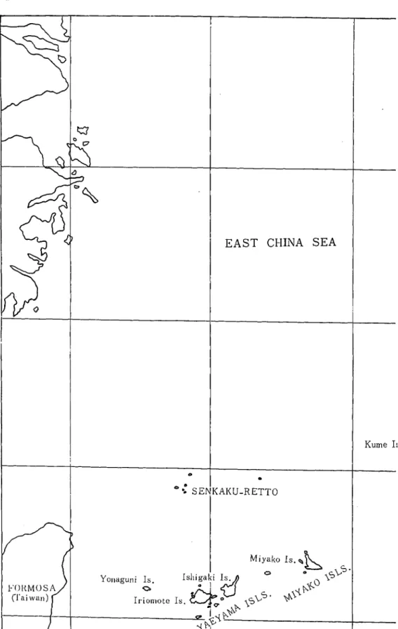
The Ryukyu Archipelago, treated in this thesis, will include islands numbering more than one hundred and forty, which are located on the curvilinear chain between southern end of the Kyushu mainland and the northeastern end of Formosa. The Archipelago is 1287 kilometers in length and is located within the area lat. 24"-31 °51' N. and long. 123°-124"-31 ° E.
The archipelago can he divided into the following five groups: 1) Tokara Islands, 2) Satsunan Islands (Osumi Islands), 3) Amami Islands, 4) Okinawa Islands, and 5) Sakishima Islands (Miyako Islands, Yaeyama Islands).
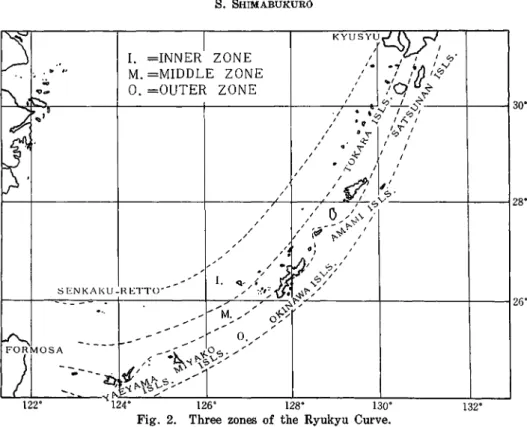
From the standpoint of the geological structure, Dr. Koto (C-3) and Dr. Hanzawa (c-l) advocates that Ryukyu Archipelago consists of three longitudinal zones. The islands belonging to the three zones are as follows:
A. The Outer Zone (Tertiary and Quaternary)-I) Tanegashima Island, 2) Mageshima Island, 3) Kikaishima Island, 4) Okierabu Island, 5) Most of the middle and southern part of Okinawa Island and the dependent islets located in the eastern ocean, 6) The greater part of Iriomote Island, 7) Kuroshima Island of Yaeyama Islands, 8) Hateruma Island and 9) Yonaguni Island.
B. The Middle Zone (consisting mostly of the Paleozoic stratum)-l)' Yaku-sihma Island, 2) Amami-oshima Island, 3) 'rokunoshima Island, 4) Y oronshima Island, 5) Most of the northern, and a small part of the middle and southern Oki-nawa Island, 6) Iheya Island, 7) Izena Island, 8) Kouri Island, 9) Iejima Island, 10) Sesoko Island, 11) Yagaji Island, 12) Ishigaki Island, 13) Kohama Island, 14) Taketomi Island and 15) Northeastern of Iriomote Island.
l!'lora of Rust Fungi In the Ryukyu Archipelago 3
C. The Inner zone (mostly Volcanic Zone)-l) Northern part of Tokara
Islands (Takeshima, Kuroshima and Iwoshima Islands), 2) Kuchinoerabu Island, 3) Southern part of Tokara Islands (Nakanoshima, Suwanoseshima, Akusekishima, Takarashima and Kotakarashima Islnds), 4) Iwotorishima Island, 5) Aguni Island, 6) Kumejima Island, and 7) Senkaku Islands.
1. Tokara Islands
Tokara Islands are located within the area from lat. 31° N. to lat. 28°46'N. and from long. 128°51'E. to long. 130°30'E. Tokara Islands run in the direction of northeast to southwest, and are a part of the Middle Zone which consist of Volcanic Zones.
The geographical elements of each island belonging to the Tokara Islands are as follows:
Circumference
i
HighestIslands Locality (km) Area in km2 i
mountain (m)
Takeshima
I
Lat.Long.30°49'130°23'N.E. 9.2 3.85 228Iwojima Lat.Long.30°48'130°14'N.E. 18.75 11.71 717
Kuroshima Lat.Long.30°50'129°56'N.E. 13.50 15.60 621
Kuchinoshima Lat.Long.29°55'09"129°55'E.N. 15.28 13.30 675
Nakanoshima Lat.Long.29°51'30"129°55' E.N. 28.04 27.55 1030
Gajashima Lat.Long.29°54'129°33'10"N. E. 9.28 4.50 509
I
Tairashima Lat.Long;29°42'129°34'30"N. E. 4.52 1.99 245
Suwanoseshima i Lat.Long.29°36'129°42'N.E. 24.48 22.33 818
Akusekishima Lat.Long.29°27'129°39'N.E. 8.76 7.04 586
Kotakarashima Lat.Long.29°12'30"129°20' E.N. 3.2 1.17 108
Takarashima Lat.Long.29°08'129°13'N.E. 12.12 5.94 291
(According to Jitto-son & Mishima-mura Office Bulletin, 1954, 1955)
Tokara Islands are under the administration of Ohsima-gun, Kagoshima Pref., Japan and consists of two municipalities; the so-called Mishima-mura and Jitto-son. Mshima-mura is located in lat. 30° N. northward and Jitto-son southward. Mishima-mura consists of the three islands, Takeshima Island, Iwojima Island and Kuroshima Island.
Takeshima Island is located in southwest of Kagoshima city and is 80 kilometers from the city. This island is closest one to the Kyushu mainland. The island runs from east to west, and is approximately 5 kilometers long' and approximately 2 kilometers wide. Its outstanding features are its volcanic origin and its plateau type topography. The seashore consists largely of cliffs. There are two mountains, called Magome-dake (228m.) and Takahira-dake (180m.). These mountains consist mostly of pyroxene-andesite and Basalt.
4
S.
SHIMABUKUROEAST CHINA SEA
Kume I:
o 0
Go SENKAKU-RETTO
1240
1260
Flora of Rust Fungi in the Ryukyu Archipelago 5 ---~---..,.__r_---_;_~32· o
'"
KAG{S
Kikaishima Is.Kuroshima Is.O
~w~:~~::h~:;Ja
Is.~.:J'
Tanegashima Is..;jj;'
I
0
~~
Yakushima Is. ",'" ",'<:- - - 1 - - - - -
Kuchinoshima Is.-'I1I1---i30·'"
Nakanoshima Is. \J Suwanoseshima Is.CT
Akusekisekishima Is.c>
Kodakarashima Is. d Takarashima Is. ~ o'"
Amami -Oshima ISff
(J~
- - - I - - - : . - - - - : . - - - I - - - i 2 8 ' Toku:oshima Is.~
.:.;;v":!·
I
~"
"
Okierabu Is.c:7
~";;; ";;; ,::>' ",.,::>",1 ~'?---...:....-~'?-=---+----:----:----:---,;;:;---i26· ~ Kjta-daito Is. ~ () Minami-daito Is.O> - - - + - - - I - - - j 2 4 · ---~_:__---~::!=---'132'128'
130' Ryukyu Archipelago.132' 6 S. SHIMABUKURO
I
KYUSY~~\) ~.1.
=INNER ZONE /~t,..(
/ ",'
'. .., YJ'
y M. =MIDDLE ZONE " I ' ' ...'" .. " ~/O/-,-~ ~~ O.=OUTER ZONE 'f-l-->o"
\o@''-~
,---+---+---+----r'-'-,---~.~.
"
~'<"---I--__f30'
~
.. ,D '1 •,,,,'I
-r-",':>, " .f1 ... It<, If
" "".
. , , ; ; :~ ,''';)'''f'"
I I 1*'
I I 1/ • ~o I I I I I I 1 1 ~ ~.' / IV/
"'C:J-·---f---j28' I / l'\ I ~C:J / / V II'\.\.;, / 1 / ,.~---:?'-~ I / \ ?'"~. I / / " 0~ " ... / / . [ / ) , ' I , / / .~~I 0"~,,,/
1.q~
/ ; : .t1
~~';II
~ENKAKU-HETTO-- " :',';~~'?'/ ,. " " " - - - t - - - \ - - - I 2 6 ' ---... //M ".L"""/
... ;.."'/ 0;':-"'-....-
"".... / ~ - - - /_- 0 . / / FI'oRM10SA ;(_-;. ,!-O",. / ' ·~--{p-..,:>v.... /-~--
_
-
,/'
~
'1/
~,"'i"'tt\.-::>,/
L-J~~---":"""-'i"':"''''-:-..:.../''-_ _,....,..,-:- .,-!- --l. --JI.-_...J 122' 124' 126' 128' 130'Fig. 2. Three zones of the Ryukyu Curve.
Iwojima Island is 7.5 kilometers west of Takeshima Island, and 6 kilometers long (from east to west) and 3 kilometers wide (from south to north). Mt. Iwo-dake (717 m.) is located near the eastern seashore of the island. It is an active volcanic mountain. The mountain is constantly belching aqueous vapor and sulphm'ic gas. There is no plant growth on or around the mountain. Mt. Yahazu-dake (340 m.) which runs from east to west is located at the northern seashore of the island. It is an old volcanic mountain.
Kuroshima Island is approximately 30 kilometers west of Iwojima Island. The island is shaped like an ellipse, which runs from east to west. It is 5.5 kilometers long and 4 kilometers wide and is a little larger than Iwojima Island. The mountains are covered with thick woods and forests. The seashore of the island is cliffs which are from 100 to 200 meters high. The rock of the island consists of alternate layers of Pyroxene-andesite lava and agglomerate.
The islands located south of lat. 30· N., that is to say, south of Nakanoshima Island, belong to Jitto-son. These islands can be divided into three groups, according to their geological features.
Nakanoshima Islnad and Suwanoseshima Island belong to the first group, and have typical volcanic topography, and the volcanic are active, even today.
Kuchinoshima Island belongs to the second group, the mountains of which are extinct volcanoes. Parts of the monutains are collapsed and they are shaped like a caldera.
Tairashima Island, Kotakarashima Island and Takarashima Island belong to the third group. These islands do not retain any volcanic characteristics, but the volcanic products present that there used to be volcanic mountains. The islands are surrounded by well-developed coral reefs, especially in Takarashima Island and Kotakarashima Island.
Flora of Rust Fungi in the Ryukyu Archipelago
7
1 - - - + - - - + - - - + - - - 1 - - - 1 3 1',
tl
Kuro-shima0
<;::l
Io-j ima Take-shima ... ... Gaja-shimaC) ~ "-,
,
...,
1---+---+---1'~-+~---r_--__'l'30° ~Kuchino-shimaI
Q
Nakano-shima Taira-shima q ( ) Suwanose-jima Akuseki-shima~
29' I - - - - I - - - + - - - _ + - - - + - - - t30' Ko_takara_shima C>0 •'\l
Takara-iima I - - + - - - + - - - + - - - + - - - t 29' ~ t:!~ Yokoate-shima 129' 129'30' 130' 130'30'8 S. SHIMABUKURO
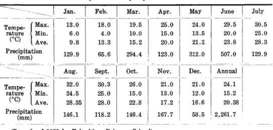
The climatic condition of the Tokara Islands is shown in the following tables. Table 1. Temperature and precipitation of Takeshima Island
129.9
----_1
Jan. Tempe-- IMax. 1--13.0 rature Min. 6.0 (0C) Ave. 9.8 Precipitation (mm) Feb. 18.0 4.0 13.3 65.6 Mar. 19.5 10.0 15.2 294.4 Apr. 25.0 15.0 20.0 123.0 May 24.0 13.5 21.& 312.0 JuneI
-~I--20.0 23.8 507.0 July 30.5 25.0 28.3 129.9 Tempe-I Max. rature Min. (OC) Ave. Precipitation (mm) 32.0 24.5 28.35 146.1 118.2 146.4 167.7 Dec. 21.0 12.0 16.6 58.5 Annual 24.1 15.2 20. 38 1 , 2,261.7 I(Records of1955 by Takeshima Primary School)
Table 2. Temperature and precipitation of Nakanoshima Island
July 30.9 23.6 27.3 248.2 June i 28.4 i I 21.1 I 24.8 463.4 I
~nnual
I 23.6I
16.7 I 20.2 3,132.1 May 25.9 18.8 22.3 304.3 18.1 11.0 14.5 176.2 Apr. Nov. Dec. 22.4 15.0 18.7 264.9 21.7 14.4 18.0 144.7 Mar. 18.6 12.4 15.5 229.2 Oct. 25.4 18.7 22.1 227.6 29.9 21.9 25.9 304.8 Jan. 14.9 9.3 12.1 165.2 31.4 24.8 28.1 182.6 Feb.I
-15.4I
10.1 12.7I
192.4-I
Aug. Sept.I
~--- i -Tempe-I Max. rature Min. CC) Ave. Precipitation (mm) Tempe-I Max. rature Min. (0C) Ave. Precipitation (mm)---
------
I
- - - ' - - - ' - - - '-(According to the Bulletin of Nase Weather Station, 1954)
Because of the fact that these islands are surrounded by the ocean, they have an oceanic climate. The weather is very warm, the annual average temperature being above 20°C. The warmest month is August and the coldest month is January. There is no forest. The annual rainfall is about 2,260 mm in Takeshima Island and 3,000 mm in Nakanoshima Island. Typhoons occur on the islands in the months of August, September and October.
2. Satsunan Islands
Satsunan Islands include Tanegashima Island, Yakushima Island, Kuchinoshima Island and Mageshima Island. They are the northernmost part of Ryukyu Archi-pelago, and are close to Kyushu proper.
Tanegashima Island is 43 kilometers southwest of Sata-point of Kyushu proper, and 115 kilometers from Kagoshima port. The gate of the island is Nishinoomote
Flora of Rust Fungi in the Ryukyu Archipelago 9
J:H'
1:l0'50' 130' 30' 130' 40'
Fig. 4. Satsunan Islands 130'2()' Kamiyaku-mura
1,;"00",,"_;;m.
- - - Y AKU-S
HIMA - - - I - - - + - - , } - - - J ' - + - - - 1~g;
no'lO' 30' H---!---·-+---+---+---f--t----,~40' H---+--+---;r:~...-____,:'__--+_----_+--=----+---l30'... /Mt.', _/ 20' f Miyanou I'aport, which is located at the northwest of the island. Itis situated in long. 131°05' E.-130°52' E. and lat. 30°50' N.-30021' N. It stretches from N.N.E. to S.S.W., and is 57 kilometers in length, and the width is from 1.2 to 6.5 kilometers. The area of the island is 447 square kilometers and it is 150 kilometers in circumference. This island is plain, like a plateau; the highest point being only 282 meters high. Like other islands within the Ryukyu Archipelago, there is an abrasion bench, from ten to twenty meters above the sea level along the coastline of this island, but this belt is not wide enough to be called a plain. Rice fields are found at several places. The stratum of this island is tertiary; the surface layer being a thick volcanic ash soil, what is called Kuroboku and Akaboku, and underneath this layer there is a clay layer, which has been formed as a result of the weathering of sandstone and shale. Very few rivers are seen in the island, the main one being Komekawa river, which
empties into Nishinoomote-machi. Many swamps are seen near Kumano on the
east coast, which is between Nakatane-mura and Minamitane-mura.
The climate is rather mild throughout the year, and it never snows on the island. Thus, about 70% of 740 species of pteridophyta and phanerogam in the island are found in Amami-oshima, 64% in Formosa and from 26 to 27% in Philippines and in Indo-China.
An outlne of the climatic conditions on the island are as follows; average annual temperature is 19°C., the warmest month is August and the coldest month is January. The temperature gets as low as 1.5°C. but it never snows and frost occurs only a few times in January. The annual precipitation is 2,500 mm., which is rather higher compared with other places. During the months from December to March, monosoons blow from the southeast. The average wind velocity is 5.5 meters, which is rather strong. Typhoon visits the island many times in the summer.
10 S. SHIMABUKURO
Table 3. Climatic situation of Satsunan Islands (Tanegashima Islands)
Jan. Feb. Mar. Apr. May June July
r=
I 14.4 15.5 17.8 21.3 24.0 26.4 30.4 Tempe-rature Min. 8.3 9.0 10.8 14.6 17.7 20.9 24.3 (OC) Ave. 11.3 12.3 14.2 17.9 20.7 23.4 26.8 Precipitation 104.9 121.9 157.6 i 207.2 382.3 650.5 209.8 (mm) Rainy days 16.4 16.0 16.8 16.4 19.0 21.0 19.8 Clear days 4.0 3.4 3.2 4.2 3.0 1.2 2.4 ~-Aug. Sept. Oct. Nov. Dec. Annual
Tempe-r
x
31.9 29.4 24.9 21.2 17.7 22.9 rature Min. 25.0 22.7 18.6 15.1 11.0 16.5 (OC) Ave. 27.8 25.6 21.6 18.0 14.3 19.5 Precipitation l26.6 346.8 173.9 170.6 79.8 2,731.9 (mm) Rainy days 7.6 18.6 14.2 12.0 12.6 190.4 Clear days 8.8 5.0 5.6 7.8 8.2 56.8 - - - ~ - - - --(According to "Climatic tables of Kyushu region" by Fukuoka District Central Me-teological Observatory, 1957)
Yakushima Island is 80 kilometers south of Sata-point, with an area of 539.37 square kilometers. Itis almost round in shape; the diameter from east to west being 27.6 kilometers and 25.2 kilometers from south to north with the circumference being about 104 kilometers. The highest mountain on the island is Miyanoura-dake which is 1935 meters high. Itis also the highest of all mountains in the Ryukyu Archipelago. Besides that mountain, there are Nagata-dake and Kuromi-dake which are 1890 and 1836 meters high, respectively.. When one sees the island from far away on the water, he gets the impression that there are nothing but rugged mountains on the island. As to the topography, this island forms three steps; the outer one is the abrasion bench, the next one is Maedake slope and to is the Okutake area, which is the center of the island. Along the coastline of the north, east and south sides of the island, there is a plateau which is from two to four kilometers wide and from one hundred to one hundred and eighty meters above the sea level. The west of this island is a bluff which borders on the water. At the second step, the Maedake slope, there are many steep mountains, which are about one thousand meters high. At the Okutake area, which is the innermost part of the island, there are many high rugged mountains, as mentioned above. The rivers which start at the Okutake are Ambo, Miyanoura, Nagata, Kurio and Taino.
An outline of the climatic information of the island is as follows:
This island has an oceanic climate. The temperature is rather high, therefore there is no frost near the coastline area throughout the year. According to the report of the Isso Weather Station, the temperature in July and February are 26.5°C. and 1l.3°C., respectively, and the average annual temperature is 18.1°C. The average annual temperature at the Kosugidani office of forestry, which is 650 meters above the sea level, is 14.9°C. There is always snow on the ground twenty centi-meters thick during the months December to March. According to the weather observation made from 1938 to 1956, the average annual precipitation at Isso was 3,752 mm. There were 208 rainy days per year during the period cited. At the
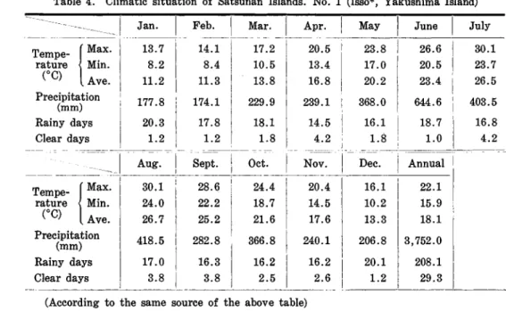
Flora of Rust Fungi in the Ryukyu Archipelago 11 Table 4. Climatic situation of Satsunan Islands. No.1 (Isso*, Yakushima Island)
4 16.1 22.1 5 10.2 15.9 6 13.3 18.1 [ 1 206.8 3,752.0 2
I
20.1 208.1I
6 1.2 29.3I
---- I June July 26.6 30.1 20.5 23.7 23.4 26.5 644.6 403.5 18.7 16.8 1.0 4.2 Annual Dec. May 23.8 17.0 20.2 368.0 16.1 1.8 Nov. ---,._--~.-24.4 20. 18.7 14. 21.6 17. 366.8 240. 16.2 16. 2.5 2. 28.6 22.2 25.2 282.8 16.3 3.8 Feb.I
Mar.I
Apr. ----~---._. -14.1 17.2 20.5 8.4 10.5 13.4 11.3 13.8 16.8 174.1 229.9 239.1 17.8 18.1 14.5 1.2 1.8 4.2 -30.124.0
26.7 418.5 17.0 3.8 ---Tempe-\ Max. rature Min. (0C) Ave. Precipitation (mm) Rainy days Clear daysJ
Jan.I
Tempe-_-\-M-ax-.- 13 8 .. 7 2 -1'1'-rature Min. (0C) Ave. 11.2 Precipitation (mm) Rainy days Clear daysI
i 177.8 20.3 1.2____
-~-_--l~-
-
Se_p_t.~_O_ct.
(According to the same source of the above table)
* Isso is located seashore on the northern part of the island.
Table 5. Climatic situation of Satsunan Islands. No. 2 (Kosugidani*, Yakushima Island)
- - - _ . - - - _..
_
.._.- - - - .- - -9.7 2.1 6.8 26.2 18.4 22.5 680.8 1120.1D:=-_,--~nnu~l-i
. 12.8 18.2 5.6 10.4 9.5 14.9 389.4 18,299.1 ' -21.1 11.8 16.8 877.1.__M_a_y_ _~une _I_JUlY 23.5
I
16.2 20.1 Mar. 1 Apr. - - - ~ Oct. Nov. 14.6 17.6 5.7 7.7 11.3 14.6 554.6 637.8 17.0 16.8 10.8 9.8 13.9 12.6 I 833.9 336.7 I Jan.I
Feb. 8.9I
1.3 6.0 Ii
442.8i
507.1A~g
---'_SePt. 25.7 24.6 18.8 16.2 22.7 21.5 1309.3 619.5 Tempe-\ Max. rature Min. (OC) Ave. Precipitation (mm) Tempe-\ Max. rature Min. (0C) Ave. Precipitation (mm)(Records by Shimoyaku Forest Office)
* Kosugidani is located nearly in the center of the island 650 m. above the sea level. Kosugidani office of forestry mentioned above, the average annual precipitation is 8,299 mm. There are seventeen rainy days per month. Typhoons pass through this island very often.
3. Amami Islands
The Amami Islands are located in the area from lat. 27° to 28°35' N. and from long. 127°23' to 130°03' E. The over all explanation of the main islands is as follows;
12 S. SHIMABUKURO
Amami-oshima Island is the largest among the islands. The circumference of the island is 569 kilometers and the area is 833 square kilometers. The island stretches from northeast to southwest. Most of the island is occupied by mountains. Mt. Yuwan-dake (694 m.) is the highest mountain of the island. The longest river is Sumiyo-kawa (16 km. long), which flows into Simuyo-wan (bay).
Kakeroma Island, which is one of dependent islets, is located at south of Amami-oshima Island. Italso stretches from northeast to southwest. The oldest stratum of the islands is Paleozoic, and Igneous rock penetrate the Paleozoic stratum here. The second oldest stratum is Riukiu limestone, which can be seen at the east seaside. Kunigami gravel covers the plateau of Kasari peninsula. The islands are surrounded by the raised coral reefs.
Kikaishima Island is approximately 24 kilometers east of Amami-oshima Island. The island is located within the area from lat. 28°17' to 28°23' N. and long'. 129°54' to 130°03' E. The circumference is 43 kilometers and the area is 62 square kilo-meters. The geological characteristic of the island can be said to be a level plain. The stratum is the Tertiary Shimajiri Group, which consists of marl and sandstone. Some part of the surface of Shimajiri Group is covered by Riukiu limestone, and some is covered by Kunigami gravel. The island is surrounded by high raised coral reefs.
Tokunoshima Island is approximately 28 kilometers southeast of Amami-oshima Island. The island is located within the area from lat. 27°39' to 27°54' N. and from long. 128°52' to 129°02' E. The circumference is 82 kilometers and the area is 247
1 - - / - - - t - - - t - - - - t " " r , - - - - + - - - - 1 2 8 " 30' 1 - - / - - - t - - - . : : : : ' - - - t - - - t - - - - 1 2 8 ' Kametsu-machi
~kinoerabu-shima
TOKUNO- SHIMA
1 - - f - - - j - - - t - - - t - - - - l 2 7 ' 30' Yoron-jima 128':W 129' 129'30' 130'Flora of Rust Fungi in the Ryukyu Archipelago 13 square kilometers. The major axis is from north to south, and is 25.3 kilometers in length. The highest mountain of the island is Inokawa-dake, which is 646 meters above the sea level. The other mountains are Amagi-dake (533 m.), Mikatadori-dake (496 m.), Mitada-dake (437 m.) and Inutabu-dake (417 m.) . The Akirigami-kawa river is 7 kilometers long, and flows into the East China Sea. The stratum of the island is Paleozoic which is mainly limestone and Kunigami gravel. There is no Shimajiri Group.
Table 6. Climatic situation of Amami Islands. No. 1. (Amami-oshima Island) Tempe- (MaX' 17.6 17.6 19.7 23.0 25.8 rature Min. 11.2 11.3 13.0 16.1 18.7 (DC) Ave. 14.3 14.4 16.2 19.3 22.0
Prect~~iion
186.5 207.7 221.0 236.2 I 345.6 Rainy daysI
22.7 20.9 19.7 18.1I
20.1 Clear days 0.7 0.5 0.9I
1.4 0.9--_--_-_-_-_---
__-_---=;J__
A_U_g_,--'__s_ep_t.J_Oct.~J==N=O=~=.
-I
D~;.
--I
--- ---- - - --_ . - - - _ . - -- - - -I 28.9 31.6 22.3 24.6 25.2 27.7 426.9 250.9 20.5 17.4 0.6 1.4 June July Annual
24.5
17.8 20.9 3,119.1 233.3 13.6 May 19.5 13.0 16.2 170.2 20.0 0.8 23.0 16.2 19.4 223.6 16.8 1.1 Mar. LApr. 26.6 19.6 22.8 272.8 18.0 1.6 30.1 23.0 26.1 270.5 19.2 2.0 Feb. 31.4 24.5 27.5 307.2 19.9 1.7 Tempe- (Max. rature Min. (DC) Ave. Precipitation (mm) Rainy days Clear days(According to "Climatic tables of Kyushu region" by Fukuoka District Central Me-teological Bureau, 1957)
Table 7. Climatic situation of Amami Islands. No.2. (Kikai, Kikai Island)
June
I
July 28.5I
32.4 22.1 25.0! .::
1·:::
I
Ann~al
I
1--
~:::-i
, 21.8 1 1,717.5 26.7 19.2 23.0 19.8 13.7 16.7 111.8 134.5 27.4 20.7 24.0 20.7 14.0 17.3 114.2 136.5 18.0 12.4 15.2 133.4 18.0 12.0 15.0 114.5 Tempe-rature (DC) Tempe-rature (DC)(
:::.'
Ave. Precipitation 120.3I
124.8 (mm) _ _ _ _ _ _ _ _1-_____
-_-J~~~t~_
I
Max.I
32.5 31.4 Min. 24.9 23.2 Ave.* 28.7 27.3 Precipitation (mm)_ _ _ _- _--_-_----'-c-:I__
Ja~_.
_1_
Feb.l\1~r~_
Apr. I May 23.8I
15.8 I' 19.8 142.9 I 207.4 ---_---.!.---.:---:__()<:1;~~~_1
Dec. 23.8I
16.7 20.4(According to Bull. of Kagoshima Weather Station, 1957) * Average of Max. and Min.
14 S. SHIMABUKURO
Table 8. Climatic situation of Amami Islands. No.3. (Kametsu, Tokunoshima Island)
Tempe-rature (OC) I I i I Tempe- (Max.
I
rature Min. I (OC) Ave.*I Precipitation (mm)I
( Max. Min. ! Ave.* i Precipitation I (mm) Jan. 18.3 11.7 15.0 147.0 Aug. 32.6 25.5 29.1 144.7 Feb. 19.6 I 12.8 16.2 156.0 Sept. 32.2 24.4 28.3 154.5 Mar. 21.6 14.6 18.1 149.1 Oct. 28.2 21.6 24.9 133.2 Apr. 24.6 16.7 20.7 174.9 I Nov. 24.4 18.1 21.3 131.4 May 27.0 20.1 23.6 246.4 Dec. 20.8 ! 14.8 17.8 130.8 June 28.9 22.8 25.9 278.8 Annual 25.8 19.1 22.6 1,972.7 July 32.5 25.9 29.2 127.8(According to the same source as No.2) * Average of Max. and Min.
Table 9. Climatic situation of Amami Islands. No.4. (Wadomari, Okierabu Island)
Tempe-rature (OC) ( Max. i Min. Ave. Precipitation (mm) Rainy days Clear days Jan. 17.9 i 12.5 i 14.9 155.5 20.0 1.0 Feb. 18.3 12.8 15.6 150.9 19.0 3.0 Mar. 20.7 15.0 17.6 146.8 18.0 2.0 Apr. 22.7 17.7 19.9 i 192.3 20.0 1.0 May 25.1 20.4 22.5 202.9 22.0 1.0 June 28.7 23.9 25.9 305.3 14.0 3.0 July 31.4 26.1 28.3 121.5 15.0 3.0
Aug. I Sept. Oct. Nov. Dec.
---=:---==--===--=-~, Annual Tempe- (Max. rature Min. CC) Ave. Precipitation (mm) Rainy days Clear days 30.8 25.3 27.8 210.5 17.0 4.0 29.7 24.4 26.8 409.9 17.0 5.0 26.7 21.4 , 23.8 102.5 12.0 5.0 23.1 18.1 20.3 157.3 14.0 I 2.0 20.2 24.6 15.0 19.4 17.2 21.7 I 95.6 2,251.0 i 16.0 204.0
I
~_~~J
_
(According to "Climatic tables of Kyushu region" (except Precipitation)" by Fuku-oka District Central Meteological Observatory, 1957)
The source of Precipitation is same as No.2.
Okierabu Island is approximately 34 kilometers southwest of Tokunoshima Island, and is located within the area from lat. 27°26' to 27°19' N. and long. 128°31' to 128°43' E. The island is the shape of a triangle, the main axis of which is from northeast to southwest, and is 20 kilometers in length. The island gets nanrrower toward the northeast. The circumference of the island is 51 kilometers and the area is 93 square kilometers. Mt. Koshiyama (189 m.) is located at the northeast part of
Flora of Rust Fungi in the Ryukyu Archipelago 15
the island, and Mt. Oyama (246 m.) is located at the southern center part of the island. Other areas of the island are mainly low plains. There is no river on the island. The circumference of the island is Riukiu limestone cliff. The plateau of the island is coral reefs.
Yoronshima Island is a small island, approximately 29.5 kilometers south of Okierabu Island and 22 kilometers from Okinawa Island. The island is covered by the raised coral reefs.
The climatic condition of the Amami Islands is shown in the above table.
4. Okinawa Islands
Okinawa. Islands are situated within the area shown by the following points of latitude and longitude: 1) Lat. 28°00' N., long. 124°40' E., 2) Lat. 28°00' N., long. 128°18' E., 3) Lat. 27°00'N~, long. 128°18' E., 4) Lat. 27°00' N., long. 131 °50' E., 5) Lat. 24°00' N., long. 133°00' E., 6) Lat. 24°00' N., long. 128°00' E. and 7) Lat. 27°00' N., long. 124°02' E.
The total area is 1,500 square kilometers. The main island is Okinawa Island, which is located within the area from lat. 26°04' to 26°52' N. and from long. 127°38' to 128°20' E.
Topographically speaking, Okinawa Island can be divided into three districts, namely; northern district, middle district and southern district.
The northern district is that north of the isthmus where the village of Ishikawa is located. The district is 67 kilometers long and from to 15 kilometers wide.
Most of the central range of mountains, which runs through the district from north to south, is covered by forests. The mountains of the range, from north to south, are Nishime-dake (421 m.), Ibu-dake (355 m.), U shikuki-dake (457 m.), Y
0-naha-dake (498m.), Iyu-dake (454m.), Tanyu-dake (390m.) and Onna-dake (366m.). Motobu peninsula juts out west,vard fronl the side of the district. Mt. Yae-dake (457 m.) and Mt. Katsuu-dake (460 m.) are located at the southern part of the peninsula.
The rivers which flow to the western coast of the district, from north to south, are Benoki-kawa, Sate-kawa, Yona-kawa, Hiji-kawa, Taiho-kawa, Genka-kawa and Hanechi-kawa. Those which flow into the eastern coast, from north to south, are Oku-kawa, Aha-kawa, Fukuji-ka,va, Kesaji-kawa, Teima-kawa and Kanna-kawa.
At the northwestern side of the northern district, there is a group of dependent islets called the Iheya Islands, which consist of Iheya Island (19.28 km2
) , Ijena Island
(26.84 km2
) and other small islets. The Iheya Islands are situated within the area
from lat.. 26°53' to 27°05' N. and from long. 127°54' to 128°02' E.
On the eastern side of l\tIotobu Peninsula, lie two islets called Kouri Island (2.93 km2
) and Yagaji Island (5.86 km2) • On the western side lie Iejima Island
(20.20 km2
) , Sesoko Island (2.78 km2) and Minna Island (0.31 km2) .
The mountains and the plateaus of the northern district are made up of Paleozoic group, which consist of Sandst.one, Riukiu limestone, slate and Kunigami gravel. The dependent islets consist of the same kind of rocks.
The middle district is the area from the Ishikawa Isthmus southward to the line which connects N aha-shi and Yonabaru-machi. The middle district is 26 kilo-meters long from north to south, with the greatest width being 17 kilokilo-meters.
The central range of mountains of the northern district extends to this middle district from the Yontanzan-dake mountain. There are abraded plateaus on the east. and south of the mountain.
Yokatsu Peninsula juts out southeast froln the northern part of the middle district, I
t
is8
kilometers long and3
kilometers wide, There are only two rivers16
S. SHIMABUKURO 250 50' 24· 30'•
.
{l
26· 10' 1 Haneji_mura 2 Yagaji-jima 3 Nakijin_rnura 4 Kami mOlobu-mura 5 Yabu-mura 6 Kin-mura 7 Koza-shi 8 Misato_mura 9 Gushikawa-mura 10 Yonaguku-mura 11 Katsuren_mura 12 Kitanakagusuku-mura 13 Nakagusuku_rnura 14 Ginowan_mura 15 Nishihara-mura 16 Haebaru-mura 17 Yonabaru_machi IB Kuncgusuku-mura +----':"O"':---l!~:___-~F---t--;L.--_7---__126· 40'<I
Tsuken-jima 26·),t;;;:;;;j~Jj---l---~==~~--;---"-\---~
50' Tomigllsllkll-mura-\l-~+'--:~ C:> Izena-jima·0
tt 128· Aguni-jima Tonaki-jima•
26·30' 26' 10' Yomi tan-mura 26·I
2 0 ' 1 - - - Kadenj-mUra Urasoe-mura 26·1---f'---,~--i1 35' 27·I---;;O.,-ll--i'f 127·40' 127"50' 128" L28· LO'Fig. 6. Okinawa Islands
in this district, one flows to the west coast called Hija-kawa and another flows to the east coast called Tengan-kawa.
The middle district is made up mainly of Tertiary strata and partly by Pareozoic strata which in turn consist of alate, Riukiu limestone, Kunigami gravel, and raised coral reefs.
The dependent islets of the middle district are in the sea to the east. They are Ikei Island (1.54 km") , Miyagi Island (4.94 km"), Hamahiga Island (2.16 km") , Tsuken Island (1.70 km"), Henza Island (2.47 km") and Kudaka Island (8 km").
The southern district includes all the area southward from the line which con-nects Naha-shi and Yonabaru-machi. The southern District is nearly triangular, and its greatest width is 20 kilometers.
Flora
of
Itust Fungi in the ll.yukyu Archipelago17
plateaus, the strata of which is made up of Riukiu limestone. The plateaus are surrounded by wide raised heach deposits.The dependent islets of Okinawa Island, besides those stated in the preceding paragraphs, are· Kumejima Island (55.06km~), Aguni Island (6.69km!!) , Tonaki Island (3.24m~) and the Kerama Islands, which are located west of Okinawa Island. Kumejima Island lies 105 kilometers west of N aha Port. The exact location of the island is from lat. 26°13' to 26°17' N. and from long. 126°42' to 126°49'5" E. It is shaped like a triangule, and its length from the southeastern end to' the northwestern end is 13.5 kilometers.
Mt. Uegusuku-dake (310 m.) is located at northern part of Kumejima Island and Mt. Ara-dake (287 m.) at southern part of the island.
Shimajiri-beds, which belong to Tertiary stratum constitute the foundation of Kumejhna Island. The upper layer of the- Shimajiri-beds consist of Andesitic agglo-merate and Andesitic lava. The foundation of the plateaus, located at western part of the island consists of Riukiu limestone. The upper l~yer of the Riukiu limestone consists of Kunigami gravel. The western seashore of the island consists mainly of raised coral reefs and raised beach, deposits.
Kerama Islands lie 37 kilometers west of Naha Port and consist of Tokashiki Island (8.95 km2
) , Zamami Island (8.48 km2) , Aka Island (1.08 knl:!) , Yakabi Island
(1.08km~) and Kuba Island (1.23km2
) . The stratum of the islands belongs to
Paleozoic group.
Daito Islands are east of Okinawa Island 287 kilometers and consist of Kita-daito Island, Minami-daito Island and Oki-daito Island.
Kita-daito Island is located at lat. 25°56'40" N. and long. 131 °17'30"E. The area of the island is approximately 18.20 square kilometers. Minami-daito Island is located at lat. 25°55' N. and long. 131 °14'42" E. It is 8 kilometers long and 4.8 kilo-meters wide and the area in 28.91 square kilokilo-meters. Oki-daito Island is located at lat. 24°32'30" N. and long. 131 °19'E. It is a small island with an area of 4.16 square kilometers.
Table 10. Climatic situation of Okinawa Islands. No.1. (Naha, Okinawa Islands)
~--- Jan.
I
T:m-p-e---(-M~X-.-I-~ 11-93~.31
1-rature Min. (OC) Ave. 16.1 Precipitation 130.8 (mm) Rainy days 18.9 Clear days 1.0 Feb. 19.1 13.1 16.0 130.0 17.3 1.0 Mar. 20.9 14.7 17.7 161.1 17.4 1.0 Apr. 23.9 17.7 20.7 157.0 14.8 1.0 May 26.3 20.3 23.1 253.5 17.4 1.0 June 29.2 23.6 26.1 269.0 16.8 1.0 July 31.2 25.1 27.9 188.5 16.1 2.0 Oct. - - - ..---==--= ---=--=--=-=---~--~---_I Aug_.- c - _S_e_p_t .----,- Nov. Dec. Annual
25.2 19.2 22.0 2,142.5 20.9 14.8 17.7 105.2 24.0 18.0 20.8 134.4 27.2 21.0 I 23.9 164.6 29.9 23.9 26.6 182.9 30.9 25.0 27.7 265.5 Tempe- (Max. rature Min. (OC) Ave. Precipitation (mm) Rainy days 18.7 17.6 15.6 14.9
I
16.2 201.7 Clear days 2.0 2.0 3.0 1 2.0 I 1.0 18.0 _18
S.
SHIMABUKUROTable 11. Climatic situation of Okinawa Islands. No.2. (Minami-daito Island)
Jan. Feb. Mar. Apr. May June July
Tempe-
I
Max. 20.8 20.9 22.4 24.0 26.7 28.6 I 30.8 rature Min. 14.3 14.7 15.8 I 18.3 20.4 23.1 25.4 (OC) Ave. 17.6 17.8 19.1 I 20.9 23.8 26.1 27.8 Precipitation 93.7 83.3 94.9 160.2 230.6 220.0 153.8 (mm) Rainy days 15.8 15.3 14.9 15.1 16.2 14.4 16.4 Clear days 3.3 2.2 2.9 2.0 2.1 1.4 3.3Aug. Sept. Oct. Nov. Dec. Annval
Tempe-
I
Max. 30.9 31.0 23.2 25.2 22.5 26.0 rature Min. 25.1 24.8 22.6 20.3 11.8 20.1 (OC) Ave. 27.7 27.5 25.2 22.6 19.6 23.0 Precipitation 157.5 93.5 156.9 165.9 101.2 1,171.4 (mm) Rainy days 18.2 15.8 18.0 17.4 13.2 I 192.3 Clear days 4.4 3.7 3.8 0.9 3.3 33.4 --- - - -- - - - ~ - ~ - - - ~ - - - _..- -- - - -----(According to the same source of No.1)
The stratum of these islands consists of raised coral reefs. The most peculiar phenomenon of these island is that each of them has a cliff seashore. The climatic data of the Islands are shown in Tables 10 and 11.
As may seen from the tables, the weat.her is warm all the year, with monthly averages ranging from 16.0 to 27.9°C., and an annual average of 22°C. Okinawa Islands being located in the ocean! its climate is naturally influenced by the semi-tropical ocean; a clear line can not be drawn the four seasons, especially spring and autumn. Even in winter the leaves of a few trees fall. The Ryukyu Islands are in the well-known eastern Asia monsoon region; therefore, the prevailing wind from autumn to spring> is northeastern, and southeastern in summer. The monsoons would not exceed 20m/s. Some typhons occur around the Ryukyu Islands every year, and few of them hit t~e island of Okinawa.
5. Sakishima Islands
The Sakishima Islands designated here include two subgroups, Miyako Islands and Yaeyama Islands.
Miyako Islands include all the islands within a triangle, of which the three apexes are lat. 27°2'N., long. 124°2' E.; lat. 24° N., long. 124°40' E. and lat. 24°N., long. 128° E. Miyako Islands consist of Miyako, Ikema, Kurima, Irabu, Shimochi, Tarama, Minna and Ogami islands; with the principal island being Miyako Island.
Miyako Island lies to the southwest of Okinawa Island about 250 kilometers. It has an area of 149.91 square kilometers. I ts geographical description is as follows. The island lies in lat. 24°55'-24°6' N. and long. 125°29'-125°10'1" E. The shape of the island is htat of a triangle, the base line of which is its southern side, with a length of 20 kilometers. Another line which runs 21 kilometers from northwest to southeast constitutes the hypotenuse of the triangle. This line is almost straight, but there is a large embayment on the Iniddle of the coastal line. The west line of the island is equivalent to the height of a right-angled triangle, along which the following are embayments; from north to south, Oura-wan, Harimizu-wan and Yonaha-wan.
Floraof Rust Fungi in the Ryukyu Archipelago
19
125'10' 125'20' 125'30' Ueno-mura 24' 1---ro;;;;:\1---Ir----F'----"cl---t---;50' 124'40' 123'30'I
SENKAKU-RETIO
I~
-25~45'----~~~MIYAKO ISLS,
24' HI---+---+=-:::--;-::::::-:-:-::-:--:::-:-:--:---~~~'---H30' c:;)IRIOMOTE-JIMA
24' I-I__-lIl,-,.o~\_l_----I__---_____t'--~-~---""r---->,dt___:;;;/---=::....---_t_j20' 24'~==:=::j:==::::::j1
30'YONAGUNI-JIMA
24' 1 1 - - - - f - - - j - - - j - - - t - 110'YAEYAMA ISLS,
o
Hateruma-jima H I - - - + - - - + - - - + - - - H24" 123'40' 123'50' 124' 124'10' 124'20'Fig. 7. Sakishima Islands
When one sees Miyako Island from a distance, the island seems to be low and flat, but there are a nllmber of mutually parallel ridges on the northeastern part of the island. All these ridges are nearly parallel on the eastern coast line of the island,
20
s.
SHIMABUKUROand have a height of about 100 meters. The highest elevation of the island is reached by Nobaru-dake (200 m.) which is a part of one of the ridges. The low and narrow abrasion benches, which developed intermittently along the shore, are a few meters above the sea. The underlying formation of the island is Riukiu limestone, which is generally covered by a reddish lateritic soil, that is thought to have been formed as a result of ,veathering of the bed rock. There are well-developed karst everywhere. Raised coral reefs are very conspicuous all over Miyako Islands.
Yaeyama Islands consists of Ishigaki, TaketoDli, Kohama, Kuroshima, Aragusuku, Hateruma, Iriomote, Hatoma an Yonaguni Islands. The principal islands are Ishi-gaki and Iriolnote. Ishigaki Island is located on the eastern side of Yaeyama Islands, lying between lat. 24°01'-24°37'N. and long. 124°4'-124°20'4"E. It has an area of 258.34 square kilometers, and is 436 kilometers a,vay from Naha of Okinawa Island, and 144 kilometers from Miyako Island. The shape of the main body of the island is nearly subquadrangular, and extends 13.5 kilometers from east to west and north to south, respectively. The area which stretches nineteen kilometers to the north from the northwest corner of the main body of the island is called Ibaruma Peninsula. The width of the peninsula is five kilometers of the widest part and four kilonleters at the narrowest part. On the northwestern corner of the main body of the island there are two snlall peninsulas; one proj ecting to the north and to the west. The former is called Kabira, and the latter Yarabu~ Both are 5 kilometers long and 2.4 kilometers wide at the widest part.
The aveTage height of the ridge ,vhich runns along the northern side of the main body of the island is 400 meters, the most prominent elevation being Mt. Omoto-dake (520m.) . On the northern side of Ishigaki-shi, steep mountains lie from east to west, namely, Mt. Banna-dake in the east and Mt. Maise-dake in the west. Both of them are 200 meters above the sea level. The area between these mountains and the northern ridge is occupied by terrace which is eighty meters above the sea. The principal rivers on the island are Miyara, Nagura and Todoroki. The island is not blessed with many rivers. In short, most of the island is mountainous, sur· rounded by coastal terraces in almost all parts of the island.
Iriomote Island is twenty kilometers long from the east to the west coast, and eighteen kilometers from the north to the west coast. The island lies within an area between lat. 23°14'6"-24°25'N. and long. 123°25'7"-123°39'E., which is nearly the center of Yaeyama Islands group. The total area is 321.88 square kilometers. It is about 32.5 kilometers away from Ishigaki Island. It is generally mountainous, with Mt. Komi-dake (400 m.), Mt. Hateruma-dake (450m.), Mt. Goza-dake (420 m.) , and others. These mountains are separated by many rivers.
On the west and south coast, the ridges of these mountains come to abrupt ends or to precipitous cliffs of two hundred to four hundred meters in height. Along the north and east coast, the dissected plateau is bordered by a high terrace. There are Nakara, Urauchi and Nakama rivers in this island. Urauchi and Nakama rivers are wide enough for a small boat of about five tons to be navigable as far as six to
~ight kilometers up the rivers.
The sandstones of the Yaeyama formation constitutes most parts of the island. A small area on the northeastern corner of the island is formed by Paleozoic rocks and raised coral reefs.
Yonaguni Island lies between lat. 24°28'-25°08'N. and long-. 122°56'-123°36'E. It has an area of 31.46 square kilometers. The long axis of the island is 11.5 kilo-meters, stretched from east to west. The width of the island is four kilometers, from north to south. Mt. Urabu-dake (231.3m.) is the J:1ighest point in the island. Tertiary and raised coral reefs constitutes most part of the island.
Flora of Rust Fungi in the Ryukyu Archipelago 21 Senkaku Islands is situated at approximately 150 kilometers northwest of Yae-yama Islands. Its exact location is from lat. 25°44' to 25°56' N. and from long. 123°28' to 124°34'E. The area of each island is as follows; 1) Uotsurijima Island (4.32km'), 2) Kobijima Island (1.08 km"), 3) Minamikojima Island (0.46 km"), 4) Kitakojima Island (0.31 km") and 5) Taishojima Island (or Akaojima Island) (0.15 km'). The
Table 12. Climatic situation of Sakishima Islands. No. 1. (Miyako Island)
I
Jan. Feb. Mar. Apr.!
May June July--- - - - ~---~I _._-
Tempe-r=
I
20.4 20.7 22.4 24.5 27.6 29.5 30.9 rature Min.I
15.3 15.4 16.9 18.9 22.2 24.5 25.4 (OC) Ave. 17.7 17.9 19.4 21.4 24.5 26.7 27.7 Precipitation 132.6 123.4 163.6 221.0 242.6 269.4 266.3 (mm) Rainy days 19.3 17.4 : 17.6 16.8 17.1 16.2 17.0 Clear days 1.9 1.1 1.8 1.8 1.1 0.7 I 1.3 - ~ - - - - _ . - ~ -iAug. Sept. Oct. Nov. Dec.
I Annual - -
-I
Tempe-r"·
30.6 30.3 27.2 24.8 22.0 25.9 rature Min. 25.0 24.7 22.6 20.1 17.2 20.7 (OC) Ave. 27.4 27.0 24.8 22.3 19.4 23.0 Precipitation 255.9 151.8 190.2 173.0 159.3 2,349.0 (mm) Rainy days 19.2 16.6 19.1 18.6 21.2 216.1 Clear days 2.7 3.1 2.4 ! 1.8 1.2 20.9 - ---~--_._- - --~------~~----According to "Climatic table of the Ryukyu" by Ryukyu weather Station, 1958. Table 13. Climatic situation of Sakishima Islands. No.2.
(Ishigaki Island)
___________-_J__
J~_n_._~Feb.
May Tempe-!
Max. 21.1 rature Min. 15.0 ("C) Ave. 18.0 Precipitation 141. 0 (mm) Rainy days 19.8 Clear days 1. 3 21.0 14.9 17.9 124.8 16.8 1.2 Mar. 22.9 16.7 19.7 141.2 16.8 1.7 Apr. 25.5 19.4 22.2 140.9 14.3 2.1 Junei
July~::~
,--:i::-r--
:~::
i
24.8 27.1 28.2 223.1 231.9 201.5 16.8 16.2 16.5 2.3 2.5 4.9 26.5 20.4 23.2 Annual 22.3 16.5 19.4 163.6 20.2 1.4 Nov. Dec. 25.1 19.2 22.0 176.6 18.3 2.5I
2,183.2 208.1I
33.8 ' ' ' ' -28.0 21.8 24.6 17.3 4.0 Oct. 199.4 30.5 24.0 26.9 238.4 31.2 25.2 27.9 218.2 Tempe-!
Max. rature Min. (OC) Ave. Precipitation (mm) Rainy days 17.3 17.7 Clear days 4.7 4.9(According to the same source of No.1)
-_____________
I
Aug. Sept.22
s.
8HIl\lABUKUROstratum of these islands is mainly sandstone of Tertiary. The climatic information of the Sakishima Islands are shown in Tables 12 & 13.
III.
Historical .review on rust fungi of the
Ryukyu Archipelago
Studies on the rust fungi native to the Ryukyu Archipelago were first begun by the late Dr. Hiratsuka, Naoharu (1873-1946) (A-8). He was a teacher of the middle school of Okinawa Prefecture from September 1899 to April 1900. During that period, he collected rust fungi, especially in the vicinity of Shuri, with the aid of his students. From among the speciInens collected, he discovered a new species, which is described below: Phakopsor-a ehTetiae Hiratsuka on Ehretia acuminatUJ R. Br. (Chisha-no-ki). Okinawa lsI.: Shuri, Jan. 6, 1899 (II, III), April 18, 1899 (Spermogonia and II) (N. Hiratsuka !), May 6, 1900 (II) (T. Maida). This is the first report on the rust fungi known in the Archipelago.
The important l"esearch reports from that thne to 1958 are as follows:
1. In 1903, Sydow, P. & H. (A-83) reported the following species; U1"edo opkio-pogonis Syd. on Ophiopogon jubl'an Lodd. "Liukiu lsI."
2. In 1906, Miyake, Tsutomu (A-63) reported the following species; Pucc'in'ict oenanthes (Diet.) T. Miyake on Oenanthe stolon'ifer'a DC. var. japonica Maxim. Okinawa lsI.: Shuri (II. Naoharu Hiratsuka, ,Jan. 6, 1899).
3. In 1909, Ito, Seiya (A-51) reported the following species from Okinawa Island; Dior~hidiumlevigatunt Syd. et ButI. on Oplismenus compositus Beauv. Oki-nawa lsI.: Shuri (II, III. Nov. 27, 1899. Naoharu Hiratsuka).
4. In 1922, Ito, Seiya (A-52) reported the following t,vo species; 1) UTomyces appendiculatus (Pers.) Link on Phaseolus vulgaJ'is L. (Ingen-1name). Okinawa lsI.: Hanechi (Aug. 9, 1904, T. Miyagi) and 2) PileolaJ'ia shiraiana (Diet. et Syd.) S. Ito on Rhus succedanea L. (Hazenoki). Okinawa lsI.: Yagachi (Aug. 10, 1904, T. Miyagi). 5. In 1935, Ide, Kiyoharu (A-50) reported a rust fungus on Raphiolepis umbel-lata Mak. from Yakushima Island as Coleopuccinia sp. It is the first account of the rust fungi froln the Satsunan Islands.
6. In 1936, Hiratsuka, Naohide (A-19) reported the following species from Yakushima Island; Kuehneola caUicaJ'pae H. Sydow on Ca.llicarpa japonica Thunb. var. Z.uxurians Rehd. (O-murasakishikibu). (Dec. 1, 1933, K. Ide).
7. In 1936, Hiratsuka, Naohide (A-21) reported the following seven species from Yakushima Island.
1) Pucciniast1·um sty1'acinum Hiratsuka on Sty1'ax japonica Siebe et ZUCCo
(Ego-noki). (Dec. 31, 1933 & Jan. 2, 1934, K, Ide).
2) P hakopsoJ·a a'rte1nisiae Hiratsuka, f. on Eupato1"ium luchuense Nakai (Shi-ma-fujibakama). (Jan. 1, 1934, K. Ide).
3) PhakopsoJ'a ampelopisidis Dietel et Sydow on Antpelopsis hete1'ophylla Siebe
et ZUCCo (No-budo). (Jan. 1,1934, K. Ide).
4) Coleosporium evodiae Dietel on Evodia glauca IVliq. (Hama-sendan). (Dec. 31, 1933 &Jan. 2, 1934, K. Ide).
5) Coleosporium paederiae Dietel on Paederia ton~entosa Bl. (Ileku8o-kazu1·a).
(Dec. 31, 1933, K. Ide).
6) Coleospo1"ium xantho~:yli Dietel et Sydow on Faga1'a schinifolia Eng!. (1nu-zansho). (Jan. 2, 1934, K. Ide).
7) Puccinia solmsii Hennings on Pe1·sica1"ia chinensis Nakai var. thunbet'giana
Flora of Rust Fungi in the Ryukyu Archipelago
23
8. In 1936, Hiratsuka, Naohide (A-22) Teported the following species from Ishigaki Island; Phakopsora ehtretiae Hiratsuka on Eh1"etia dicksonii Hance. var. liukiuensis Nakai (Ryukyu-chisha-no-ki). (March 6, 1925, T. Miyagi). This is the first report on rust fungus from the Sakishima Islands.
9. In 1936, Hiratsuka, Naohide (A-20) reported the two species from Yakushima Island; 1) Pucciniastrum a.gri11tOniae (Diet.) Tranzschel on Agroimonia pilosa Ledeb. (Kin-'lnizuhiki) and 2) P. styracinum Hiratsuka on Styrax japonica Siebe et Zucco (Ego-no-ki) .
10. In 1937, Hiratsuka, Naohide (A-23) reported two species from Yakushima Island, three from Amami-oshima Island, and two from Okinawa Island. These species are listed below.
1) Maravalia hyaloslJO'ra (Sawada) Dietel on Acacia confusa Merr. Okinawa
Island: Shuri (J.an. 5, 1899, Naoharu Hiratsuka).
2) Coleopucciniella idei Hiratsuka, f. on Raphiolepis urnbellata Mak. Yakushima
lsI. (Dec. 1933, K. Ide).
3) Uromyces pY1"ifo1"mis Cooke on Acorus calamus L. Amami-oshima Island: Nase (April 3, 1935, T. Tamotsu).
4) Puccinia congesta Berkeley et Broome on Pettsica1"ia chinensis Nakai var. thunbergiana Nakai. Yakushima lsI. (Dec. 31, 1933, K. Ide). Amami-oshima lsI.: Mikata-mura (July 23, 1936, T. Tamotsu); Nase (July 2, 1935, T. Tamotsu). Oki-nawa lsI.: Shuri (April 22, 1899, Naoharu Hiratsuka).
5) Hemileia gardeniae-floridae Sawada on Ga/rdenia jasminoides Ell. var. g1"andi-flora Nakai. Amami-oshima lsI.: Tatsugo-mura (Oct. 15, 1936, T. Tamotsu).
11. In 1938, Ito, Seiya (A-53) reported the following two species as native to the Ryukyus; 1) Bubakia ehr'e'tiae (Hiratsuka) S. Ito on Ehreti(J) dicksonii Hance.
var. liukiuensis Nakai and E. taiwaniana Nakai and' 2) Coleosporium asterum (Diet.)
Sydow on Aster indicus Fisch.
12. In 1940, Hiratsuka, Naohide and Taira,' Yoshihisa (A-44) reported the following interesting- species from Okinawa Island; Skierka agallocha Raciborski on Excaecar'ia agallocha L. var. genuina Mul1.-Arg. (Okinawa-jinko, Shima-shi1'·aki).
Okinawa lsI.: Naha (March 15, 1940, Y. Taira).
13. In 1940, Hiratsuka, N aohide (A-26, 27) reported nineteen genera and seventy-six species from the Ryukyu Archipelago. They are: as follows Melamp-soraceae (16sp.)-Milesina 2 sp., Hyalopsora 1 sp., Pucciniastrum 1 sp., Phakopsora
4 sp., Coleopucciniella 1 sp., Angiopsora 1 sp., Coleosporiu11~ 6 sp., Pucciniaceae (50
sp.)-Skierka 1 sp., Flemileia 1 sp., Pileolaria 1 sp., j(uehneola 1 sp., Hamaspora 1 sp., Phrag'}nicliu1n 1 sp., Ravenelia 2 sp., Poliotclium 1 sp., Uromyces 11 sp., Puccinia 30
sp. and Uredinales Imperfecti (10 sp.)-Aecidium 6 sp., Uredo 4 sp. This work is the first intensive study on the rust fungi of the Ryukyu Archipelago. They include seventy-four species from Okinawa Island; and three from Amami-oshima Island. Among them, the following new species is included: Uromyces tairae Hiratsuka, f. on Messersch1nidia argente(J) John. Okinawa lsI.: Mabunimura (March, 1940, Y. Taira).
14. In 1940, Hiratsuka, Naohide (A-28) reported the following- species; U1"omyccs lespedezae-procumbentis (Schw.) Curtis on Lespedeza cuneata G. Don. Okinawa lsI.:
Kanegusuku-mura (Hiratsuka, f.).
15. In 1941, Hiratsuka, Naohide (A-3D) reported twenty genera and ninety-six species native to Okinawa Island. In his paper, the following three new species were' described; 1) Puccinia benoki1Jarnens.,is Hiratsuka, f. on Ampelygonum umbellatum
Masam. Mt. Benokiyama (Kunig'ami-gun) (April 10& 11, 1940, Y. Taira), 2) Puccinia lepturi Hiratsuka, f. on Lepturus 1'epens R. Br. Naha-shi (Jan. 15, 1940, Hiratsuka,
24
s.
SHIMABUKUROMt. Benokiyama (Kunigami-gun) (April 11, 194'0, Y. Taira).
16. In 1944, Hiratsuka, Naohide (A-32) reported seven genera and twenty-one species of Melampsoraceae, as native to the Ryukyu Archipelago, in his paper, entitled, "Melampsoracearum Nipponicarum". In this paper, seventeen species from Okinawa Island, eight from Yakushima Island, five from Amami-oshima Island, and one from Ishigaki Island, are reported.
The papers listed below have been published from the end of the War to the present:
17. In 1952, Hiratsuka, Naohide (A-34) reported "Uredinales of Kiushu." In this paper, he reported forty-one species from Yakushima Island, eight from Amami-oshima Island, and one from Tanegashima Island. Among them, the following two new species are included; 1) Aecidium satsumenS6 Hiratsuka, f. on Arisaema ringens
Schott. yare praecox EngI. (Musashi-abumi). Tanegahimsa lsI.: Nakatane-mura (May 3, 1940, S. Itoga) and 2) Uromyces yakushimensis Hiratsuka, f. et Katsuki
on Trichosanthes multiloba Miq. (Momiji-kar'asuu/ri). Yakushima lsI. (Oct. 13, 1949, S. Katsuki).
18. In 1953, Katsuki, Shigetaka (A-59) reported five species of rust fungi from Yakushima Island.
19. In 1953, Morimoto, Yasuji (A-64) reported seventeen species belonging to Melampsoraceae, fifteen of Pucciniaceae and five of U redinales Imperfecti from Yaku-shima Island. Among them, the following three new species are included; 1) Miles'i'na hiratsukai Y. Morimoto on Plagiogyria japonica Nakai. Yakushima lsI.: Kosugidani (June 2, 1951, Y. Morimoto), 2) Uredo yakushim.ensis Y. Morimoto on Psychotria serpens L. Yakushima lsI.: Haro-mura (June 5, 1951, Y. Morimoto), and 3) Uredo horikawai Y. Morimoto on Diospyros nipponica Nakai. Yakushima lsI.: Haro-mura
(June 5, 1951, Y. Morimoto).
20. In 1955, Katsuki, Shigetaka (A-60, 61) reported thirty-eight species of Melampsoraceae, forty-nine of Pucciniaceae, and nine of Uredinales Imperfecti; a total of ninety-six species from Yakushima Island.
21. In 1956, Morimoto, Yasuji (A-65) reported fourteen genera and forty-eight species from Amami Islands.
22. From 1954 to 1957, Hiratsuka, Naohide, Shimabukuro, Shunichi et al. (A-38, 39, 40, 41, 43, 44) engaged in more intensive studies. on rust-flora of the Archipelago. The papers disclosed the following four species; 1) H amaspol'a okinawensis Hiratsuka,
f. on Rubus utchinensis Koidz. Okinawa lsI.: Mt. Katsuu-dake (Jan. 14, 1941,
Hira-tsuka, f.), 2) Pucinia ca.ricis-boottianae Hiratsuka, f. on Carex brunnea Thunb.
Okinawa lsI. etc., 3) Uromyces thermopsidicola ShiInabukuro on The1'mopsis chinensis
Benth. Okinawa lsI. etc. and 4) DidY1nopsor'ella lemanensis (Doidge) Hiratsuka, f. on Toddcilia asiatica Lam. Okinawa lsI.
.23. In 1958, Hiratsuka, Naohide (A-37) reported the following seventeen species belonging to Pucciniastreae native to the Archipelago; Uredinopsis 2 sp., Milesina
5 sp., Hyalopsora 2 sp., and Pucciniastrum 8 sp.
24. In 1958, Hiratsuka, Toshiko (A-46) published the reuslts of her taxonomic studies on the species of the rust fungi parasitic on the grasses from the southern Kyushu and the Ryukyu Islands. In her paper, the following 44 species are recorded from the Archipelago; Phakopsora 1 sp., Dasturella 1 sp., Uromyces 5 sp., Puccinia
36 sp. and Uredo 1 sp. Among them, the following new species is included; Puccinia' arundinnis-donacis T. Hiratsuka on A rundo clonax L. (Danchiku). Miyako lsI.: Shhnochi-machi (Feb. 17, 1955, M. Tamori).
Flora of Rust Fungi in the Ryukyu Archipelago
IV.
Geographical distribution of rust fungi found
in the Ryukyu Archipelago
25
1. The number of species in each group of islands.
According to the study on the number of species in each group of Islands in the Ryukyu Archipelago, the total numb€:r known up to 1959 is 269 species. A summary of the data by islands is shown below, and a detailed distribution is shown in Table 15.
Table 14. Number of Species of rust fungi in each group of islands in the Ryukyu Archipelago
Islands Number of genera Number of species
Satsunan 25 154 Tokara 17 104 Amami 24 110 Okinawa 31 174 Sakishima 20 112 Total 39 269
The largest nunmber is found on Okinawa Islands, and fewer in the regions of Satsunan Islands, Sakishima Islands, ...l\.mami Islands and Tokara Islands, in that order.
This is due to Okinawa Islands having many species of host plants, and because of the comparatively large area. The main reason causing the abundance' in the number of species in the Satsunan Islands, which is second largest in the number of fungi species concerned, is that it has high mountains, which usually cause the vertical distribtuion of fungi.
In order to compare the number of species common in the neighboring regions, the Japan Archipelago was divided into the following four regions; Kyushu, Shikoku, Honshu and Hokkaido; and Formosa, which is located south of the Ryukyu Archi-pelago, was added as one region. Tables 16& 17 show the comparison of each of the above regions with five groups of islands which nlake up the Ryukyu Archipelago.
Analysis of Tables 15 and 16:
1) Seventy-six percent of the species found on Sakishima Islands are common to Formosa, and a smaller percent in the regions of Shikoku, Kyushu, Honshu and Hokkaido. This is due to the fact that Sakishima Islands are geographically closest to Formosa.
2) Sixty-nine percent of the species found on Okinawa Islands are common to Formosa. It becomes less in the regions of Kyushu, Honshu, Shikoku and Hokkaido, in that order.
3) Eighty-three percent of the species found on Amami Islands are common to Fromosa. It becomes less in the regions of Kyushu, Honshu, Shikoku and Hokkaido, in that order.
4) In Tokara Islands, seventyeight percent of the species are common to Honshu. It becomes less in the regions of Kyushu, Formosa, Shikoku and Hokkaido, in that orde,r.
5) In Satsunan Islands, seventy-eight percent of the species are common to Kyushu. It becomes less in the regions of Shikoku, Honshu, Formosa and Hokkaido, in that order. This fact can be easily understood because the islands lie geographical-ly closer to Kyushu.
26 S. SHIMABUKURO
Table 15. Number of species of rust fungi on each group of Islands
Islands Satsunan Tokara
1 2 2 4 26 3 3 40 3 20 11 1 5 1 1 1 2 1 3 3 1 3 1 2 8 36 54 6 82 22 1 1 1 10 1 1 1 1 1 3 4 3 1 3 8 35 51 4 2 '6 78 21 10 4 1 1 2 1 2 1 3 1 3 8 36 51 5 1 6 79 22 1 10 1 1 3 1 1 1 2 6 6 36 47 4 5 9 78 22 1 1 10 1 39 2 1 3 1 7 62 4 32 2 o '"0 '@
~
lJ:: 2 1 2 3 1 1 2 20 1 1 2 1 2 2 6 2 6 1 3 4 1 12 49 41 69 3 5 8 1 1 1 13 1 118 1 1 6 6 2 2 7 7 1 1 3 3 5 6 1 1 1 1 1 1 2 1 1 1 2 2 1 1 1 13 13 1 1 41 41 13 13 51 50 1 72 71 6 4 3 5 9 9 122 121 2 1 1 2 1 1 2 1 5 2 8 1 1 10 42 35 1 2 12-I
I
60 I i~
I '1 15 110 Regions Total Genera Zaghouania Skierka Didymopsorella Gerwasia Hemileia Pileolaria Kuehneola Tranzschelia Hamapsora Phragmidium Hapalophragmium Sphaerophragmium Ravenelia Nothoravenelia Endophyllum Maravalia Poliotelium Gymnosporangium Uromyces Puccinia Xenostelei
-Jl~ IAe~idium
-,S~ 1 1 _Uredo'g&
-~..§_Total_ 0 Tota 1 Uredinopsis Milesina I Hyalopsora Melampsoridium Pucciniastrum Thekopsora Melampsora Phakopsora Cronartium Crossopsora Cerotelium
I
Coleopucciniella Dasturella Pucciniostele Coleosporium I OchropsoraI
Total ~ -I6) From the above mentioned facts regarding the distribution of the fungi, the boundary separating for the species in to subtropical-and-tropical and warm-temperate zones appears to lie between Amami Islands and Satsunan Islands.
7) Table 16 is the comparison of the number of common species of neighboring regions with the Ryukyu Archipelago as a whole, It shows that Formosa comes first, Kyushu second, Honshu third, Shikoku fourth and Hokkaido fifth.
Flora of Rust Fungi in the Ryukyu Archipelago 27
in the Ryukyu Archipelago common to the neighboring regions
1-Amami Okinawa Sakishima
-~ 0 ~ 0 ~ 0 ~ P "'C P P "'C P P "'C rn p
0;
rn p0;
p";
I 0 ,.d.-a
,.d 0 ,.d ~ ,..d 0 ,.d ~ ,..d S rn rn ~ S rn 0 rn ~ S rn 0 rJ'J ~ I ~ ~ ~ $:I ~ ~ ~ ~ l=l ~ ~ ~ ~ l=l ~ 0 ~:a
0 0 ~:a
0 0 0 ~:a
0 0 ~ ~ 00 P:t P:t ~ ~ 00 P:t P:t ~ ~ 00 P:t P:t - - - -1 1 1 1 1 1 1 3 3 3 1 2 2 2 1 2 1 2 2 1 1 1 1 1 1 1 5 5 4 4 2 3 3 3 2 2 ! 1 1 1 1 2 2 2 10 5 6 4 2 10 5 6 4 2 11 6 7 4 1 1 1 1 1 1 1 1 1 1 1 2 1 2 1 1 1 1 1 1 1 1 10 10 10 9 4 10 10 10 9 4 5 5 5 4 2 1 1 1 32 29 27 28 13 26 24 25 24 11 20 12 13 10 3 - - - ~~--1 1 1 1 1 1 1 1 1 1 1 1 1 1 1 1 1 1 1 1 1 1 1 1 2 1 2 1 2 1 2 1 2 1 2 1 1 1 1 1 1 1 1 1 1 1 1 1 1 1 2 2 2 2 2 2 2 2 2 2 1 1 1 1 1 1 2 1 1 1 1 1 1 1 1 1 1 1 1 1 1 1 1 1 1 1 1 1 ]4 17 16 15 7 18 21 19 19 9 10 12 12 11 5 28 26 25 24 14 49 51 46 49 32 35 29 30 27 15 1 1 2 1 . - - - ~ - - - - _ . -51 51 49 48 24 82 82 76 79 45 51 45 46 44 22 4 3 3 3 6 7 5 6 3 7 4 3 3 1 5 1 1 1 7 2 1 1 8 1 1 --- -'--_.._-- - _ . - - - . _ -9 4 4 4 13 9 6 7 3 15 5 4 3 1I
- - - -I 92 84 80 80 37 121 115 107 110 59 86 62 63 57 26 - - - -- - - -~ - - - - ~ _ . _ - - - -~---- ~ ~-This ~s reasonable because of the geographical location of the Ryukyu Archipelago. Especially, it is noteworthy to know that many species belonging to Uredinales Im-perfecti in the Ryukyu Archipelago are common to those of Fromosa. Namely, the rust fungi which are native to tropical and subtropical regions seldom produce teleutospores. Those statements generally coincide with already existing opinions.
28 S. SHIMABUKURO
Table 16. Number of species of rust fungi in the Ryukyu Archipelago common to the neighboring regions
3 1 1 7 23 \
Hok-I
kaido 1---2 -1 3 1 3 1 1 2 1 2 8 8 2 3 1 1 7 , 7 1 1 3 3 8 5 1 1 1 2I
1 1 1 13I
13 1 1 48 49 -1 I 1I
1 1I
1 1 1 2 1 1I
1 1 4 4 2 8 1 3 7 1 1 1 1 1 2 1 1 349
1 13 1 3 1 1 1 2 1 1 1 2 12 1 2 1 1 1 2 12 Regions Total Zaghouania Skierka Didymopsorella Gerwasia Hemileia Pileolaria Kuehneola Tranzschelia Hamaspora Phragmidium Hapalophragmium Sphaerophragmium Ravenelia Nothoravenelia Endophyllum Maravalia Poliotelium Gymnosporangium Uromyces Puccinia Xenostele Genera Uredinopsis Milesina Hyalopsora Melampsoridium Pucciniastrum Thekopsora Melampsora Phakopsora Cronartium Crossopsora Cerotelium Coleopucciniella Dasturella Pucciniostele Coleosporium Ochropsora I I Ryukyu I· I h(Total)
i
FormosaI
Kyus u Shikoku Honshu--Y-I-
~~I- -~-i~---13 1
I
3 1 I 8 6 1 3 12 1 3 1 2 1 2 146:
1--4-4~
- - - - 1 - - - - 1 1 1 1 1 1 2 3 1 3 4 11
:
I
1 1.
~
~
I
\
1 1 35 I 19I
2~
I2~
2~
10i
w~
~
~
I
~
~
~
----ur=-I,I-
---T-o-ta--I---I_--=2611 -11-101231-
1~170-~_-!-1OO8 --l048-1~49
~~ Aecidium
__-_j_J-__
-I~-
__
-u~-:_-:O-t:;t-a-l~
26:1=1:1
,::.! ..
,::~i~:-i~;=
Islands-belongs politically to Kagoshima prefecture, Japan, the rest being governed by the Government of the Ryukyus. The following is the table of number qf species found in the two regions:
Flora of Rust Fungi in the Ryukyu Archipelago 29 Table 17. Number of species of rust fungi in Kagoshima Pref.
and that of Okinawa Pref., prior to the War
203 40 134 29 205 Nurnber of species
Kago~~~-·IOkin~:~h~r;:rlor--~~ 57 -!~--~-118 30I
I
_ _ _ _ ----~---- ~_I_- ~_ Total Family ~elarnpsoraceae Pucciniaceae Uredinales Imperfecti2. The rust-flora in each zone of the Ryukyu Archipelago.
As has been described previously, the Ryukyu Archipelago can be divided into three zones-outer, middle and inner-in accordance with geographical differences.
The number of genera and species of rnst fung in each zone is listed accordingly, in Tables 18, 19 & 20. Table 18 shows that the largest number of species is in the middle zone, next in the outer, and last in the inner; being 223, 167 and 129, respec-tively.
The difference in the number of species from one zone to the other, is not thought to be caused by the geological constitution of each zone, but rather by the size, shape and esepcially the elevation of the islands belonging to each zone. In addition to these factors, the species and number of host plants in each zone seem to affect the number of species of rust fungi.
Table 19 indicates the number of particular species according to the following classification:
a) Those found only middle zone, but· not in the other zones (outer and inner zones) .
b) Those found only in outer zone, but not in the others. c) Those found only in inner zone, but not in the others.
It can be seen in Table 19, that species peculiar to each zone are around in the largest number in the middle zone, and the least in the inner zone. In Table
?O,
the common species in each zone for neighboring regions are listed.For Melampsoraceae, the species in the inner and outer zones are found in the greatest number in Formosa, and the species in the middle zone occur rather densely in Kyushu and Honshu.
For Pucciniaceae, the outer zone is most highly tied with Kyushu, middle zone with Formosa and Kyushu, and inner zone with Honshu.
For Uredinales Imperfecti, all zones-inner, middle and outer~arerelated mostly to Formosa. In general, the outer and middle zones are most similar to Foromosa; with the inner zone being more similar to Kyushu; but the degree of similarity is almost negligible.
3. The endemic and introduced species of the rust fungi in the Ryukyu Archipelago. Biologists have different opinions as to the meaning of endemic species. The author considers endemic species to be those native to the Ryukyu Archipelago, and which have not yet. found in other regions. It is impossible to tell whether these species are palaeoendemic, :i.e. these having been existed from the remote past, or neo-endemic, Le., these generated in comparatively recent times.
In accordance with the above concept, the endemic species in the Ryukyu Archi-pelago are the nine species listed belov/; 1) Ha1naspora okinawensis Hiratsuka, f.,
2) Uromyces kunigamiensis Shimabukuro, 3) "[.l. tairae Hiratsuka, f., 4) U. thermo-psidiocola Shimabukuro~ 5) U. yakushimensis Hiratsuka~ f. et Katsuki, 6) Puccinia
30 S. SHIMABUKURO
Table 18. Number of species of rust fungi found in each zone of the Ryukyu Archipelago
Nurnher of species
Families Genera
Outer Middle Inner
U redinopsis 2 1 Milesina 3 5 3 Hyalopsora 3 1 ~elampsoridium 1 Pucciniastrum 4 8 3 Thekopsora 1 Melampsora 2 3 Phakopsora 11 11 9 Melamp- Cronartium 1 soraceae Crossopsora 3 2 1 Cerotelium 1 Coleopucciniella 1 2 1 Dasturella 1 1 1 Pucciniostele 2 Coleosporium· 9 14 12 Ochropsora 1
-I
ZaghouaniaTotal 34 58 321 Skierka 1 Didymopsorella 1 1 Gerwasia 1 1 1 Hemileia 1 Pileolaria 1 2 1 Kuehneola 3 2 2 Tranzschelia 1 Hamaspora 1 3 1 Phragmidium 2 2 3 Hapalophragmium 1 Pucciniaceae Sphaerophragmium 1 Ravenelia 1 2 1 Nothoravenelia 1 1 1 Endophyllum 2 2 Maravalia 1 Poliotelium 1 1 1 Gymnosporangium 1 Uromyces 27 24 13 Puccinia 72 83 57 Xenostele 2 I I T()tal I 117 128 82 I I -I, Aecidium 8 17 7 Uredinales Dredo 8 21 8 Imperfecti ~ -Total 16 38 15 TotaI 167 224 129lepturi Hiratsuka, f., 7) P. scirpi-ternatani Hiratsuka, f., 8) Uredo horikawai Y. Morimoto and 9) U. yakushi1nensis Y. l\1:orimoto. They constitute 0.0330/0 of the total number of the rust fungi in the Ryukyu Archipelago.
Besides the above eight species, the following twenty genera, sixty-five species found in the Ryukyu Archipelago have not yet been found in Japan proper.
1) Phakopsorra formosana Syd., 2) Ph. glochidii (Syd.) Arch., 3) Ph. malloti
Cummins, 4) Ph. tecta Jackson, 5) C'rossopso1'a antidesmae-dioicae (Syd.) Arch. et Cummins, 6) C~ rnalloti (Racib.) Cummins, 7) C. pt'emnae (Petch) Syd., 8) Cerotelium