九州大学学術情報リポジトリ
Kyushu University Institutional Repository
エジプトにおける都市スプロールエリアのトレント 水害リスクの予測
オマル, ハメディ モハメド イルハナフィ アベドリカリーム
https://doi.org/10.15017/1806790
出版情報:Kyushu University, 2016, 博士(人間環境学), 課程博士 バージョン:
権利関係:Fulltext available.
A Dissertation Submitted
In Partial Fulfilment of the Requirement For the Degree of
“Doctor of Philosophy”
In Urban Design, Planning and Disaster Management
by
Omar Hamdy Mohamed Elhanafy Abdelkareem
To the
Department of Urban Design, Planning and Disaster Management Graduate School of Human-Environment Studies
Kyushu University Fukuoka, Japan December, 2016
I
Acknowledgements
LHAMDULILLAH, and peace and blessings be upon the Prophet of mercy Mohamed. All Praise be to Almighty Allah, the Creator and Lord of the whole Universe, who blessed me with limitless strengths and patience to pass through all odds and made this work to come to fruition. Allah creates sources for helping his Ummah and I am conscious of many of the debts of gratitude to acknowledge.
Undertaking this PhD has been a truly life-changing experience for me and it would not have been possible to do without the support and guidance that I received from many people. Though it will not be enough to express my gratitude in words to all those people who helped me, I would still like to give my many, many thanks to all these people.
First and foremost I would like to express my special appreciation and thanks to my supervisor Associate Professor Dr. Shichen ZHAO, who offered me so much advice, his guidance helped me in all the time of research and writing of this thesis. I would like to thank you for encouraging and continuous support of my Ph.D. study and related research.
I also want to show my great thanks to the judgement committee, Professor Takeru Sakai, Associate Professor Prasanna Divigalpitiya and Associate Professor Daisuke Sumiyoshi for their reviewing, providing valuable advices and constructive suggestions for my thesis improvement.
I would also appreciate the advice of my supervision members in Egypt, Professor Dr. Yohansen Yahea, Professor Dr. Mohamed A. Salheen, for their critical comments, which enabled me to notice the weaknesses of my dissertation and make the necessary improvements according to their comments. All my Deep thanks appreciate for my home university Aswan University in Egypt for all kind of support and help have been given for me.
A c k n o w l e d g e m e n t s
II
This work would not have been possible without the financial support of my Egyptian Government and Cultural Affairs & Missions Sector by gave me a scholarship and funding my research. Also, I would like to thank all staff members of Egyptian Cultural & Educational Bureau in Tokyo for their helping in all my staying years in Japan.
This thesis is dedicated to the memory of my beloved father, Hamdy Elhanafy, It is your shining example that I try to emulate in all that I do. I deeply miss my father, who is not with me to share this joy, I would like to see you in my public defence like what he attended my master defence. I ask Allah Almighty to forgive and bless him, I ask Allah Almighty to bring us together in the highest paradise.
I am very grateful for my mother. Her understanding and her love encouraged me to work hard and to continue pursuing a Ph.D. project abroad.
Her firm and kind-hearted personality has affected me to be steadfast and never bend to difficulty. She always lets me know that she is proud of me, which motivates me to work harder and do my best. Your prayer for me was what sustained me thus far.
I would like to say a heartfelt thanks to my caring, loving, and supportive wife. She has been a constant source of strength and inspiration.
I can honestly say that she was constantly give me her determination and constant encouragement. She took every responsibility and suffered all the bitterness to take care of my daughter and my family. While I completed my work. My heartfelt thanks.
My daughter, a source of unending joy and love, has been wonderfully understanding throughout the dissertation process and has been awaiting the day when I would be finished. Now, we will be able to play outside, my lovely sweet daughter Hafsa, please forgive my dereliction with you because I was very busy in my PhD study, I promise you that I will compensate you in the next period.
III
I also want to show my great thanks to my sister, my brothers, mother- in-law, father-in-law, my uncles and all my relatives for their support and good wishes, who have always stood by my side with their moral support and inspiration. This has played a vital role from the beginning of work, without which I would not have been able to do, all that I have done.
I would also like to thank all of my friends (too many to list here but you know who you are!) who supported me in writing, and incited me to strive towards my goal. They provided me the friendship that I needed. I thank them not only for all their useful suggestions but also for being there to listen when I needed an ear.
I would also like to say a heartfelt thank you to the most beloved community in my stay the first one is FMC (Fukuoka Muslim Community) and the second one is ESAJ-F (Egyptian Students Association in Japan- Fukuoka), I have to give all members in both community my deep thanks for supporting and helping me and my family since my first day during three years in Japan.
All praises is to Allah and to Him alone. Every nerve ending, joint, limb, organ, and faculty of mine is indebted to Allah (S.W.T.) for all the bounties He bestowed on me to enable me to alhamdulillah (praise be to Him) successfully finish this thesis. Words are insufficient to describe my gratefulness and appreciation to Him in the whole process of the preparation, compiling and writing of this thesis. In moments of distress, He guided me, showed me what to do, removed all obstacles from and lighted my path, inspired me, eased the tedious task of writing, and gave me surplus energy so that I may stay up night after night, putting down words on paper. Without Him I would not have been able to undertake this daunting task. He is my world, always there in every moment! What matters to me is that He accepts this contribution of mine that He inspired me to write; assisting me by sending me various messengers at every crucial turn. I also would like to ask him that this project would be another tool to help and save people from the natural disasters. Thank You Allah!
IV
Abstract
Natural hazards are a naturally occurring event that might have a negative effect on people or the environment, which are caused because of natural phenomena. Examples of natural hazards are cyclones, tsunamis, earthquake, volcanic, Landslides, floods. Torrents are one of the most important natural disasters that threaten with destruction of urban areas, especially those which are located directly in the areas of storm water drains, where the rush of water is very large and the concentrated amounts makes huge destruction for the buildings, streets, and infrastructure of the region.
Using ArcGIS - Hydrology Tools that can gives fast tool to identify the risk area but still it has primary estimation because depends on single source of data , also it doesn’t take into account the land use maps and soil maps when study or identify the risk area. The second part was the safe area with buildings located outside the hazard zone. To make this classification, we used the GSSHA model by WMS software to simulate rainfall and surface water runoff in the case study area.
The world has witnessed a frightening increase in the frequency and harshness of disasters, with 240 million people on average being pretentious by natural disasters universal each year between 2000 and 2005. In 2007 alone, 414 natural disasters were informed, killing 16847 persons, harming or displacing more than 211 million others, and affecting damage estimated at over 74.9 US$ billion.
Urban sprawl, a serious problem for many rapidly developing countries, refers to the uncontrolled growth of an urban area resulting from poorly or totally unplanned urbanization. The encroachment of urban land uses on non-urban land has become a common phenomenon throughout
A b s t r a c t
V
developing countries. Particularly, the urban sprawl will discontinuously expand around old urban cores, and continue surround major road networks.
The findings proved that the desired urban sustainable development in Aswan will not be assured in 2037, proving that the historical growth trends is not a proper scenario to achieve the urban development sustainability goals of GOPP, 2005.
The purpose of this research can be describe as trial to achievement the following specific objectives. To determine different methods can help in identified the risk area which it was prone to torrents these methods can gives fast tool to identify the risk area from natural environmental disasters as a very important step in disasters risk management. To identify torrents simulation uses free and easy access data in can generate primary results close to real live situations. It is necessary to perform simulations of the potential site to avert the threat of natural disasters. To describe simple and plain methodology to determine the approximate periods for buildings that have been where construction by using manual photo-interpretation from satellite imagery. This methodology will be very useful in determine the urban sprawl. To extract the driving factors that can led the urban sprawl to try understanding the expansion of urban area, and helping the decision- makers and planners to expect the urban growth in future. To estimate the future urban area situation by identify fast and easy method to expecting the future urban sprawl that will help the government officials in estimate the expanding of urban area in risk area porn to natural disasters.
In the following point the research will give a brief description about the chapters:
Chapter 1: This part describes the background of three main definitions, first the natural environmental disasters in the world specifically
VI
shows the impact of torrents and flooding, the second one is some definitions about risk and disaster risk management especially the mean of flood disasters managements in Arab Region, further this chapter describes the importance of this study and what is the research objectives which the methodology have to achieve it, In the end of chapter there is the skeleton of the research thesis.
Chapter 2: This chapter suggest uses two method to identify the risk area comes from the natural disaster (Torrents), first one using ArcGIS - Hydrology Tools to delineate the watersheds and stream drain, the second method that the research uses GSSHA model to simulate the torrents in study case area. Those methods has many benefits especially for planners and decision makers in development countries, the first one those methods are very easy access and common use by very famous software such as ArcGIS, Second benefit is all data which used in this part is free data.
Chapter 3: This section analyses the past urban growth based on the study of the region in different time periods and identifies urban growth by a visual analysis of high-resolution aerial historical images of the city in Google Earth. Furthermore extract the driving factors that can led the urban sprawl using Land Change Modeler in IDRISI®Selva software, this method is very useful to try understanding the expansion of urban area. Moreover this chapter try to estimate the future urban sprawl by using method depend on the Logistic regression and Markov Chain Model.
Chapter 4: This chapter aims to identify the risk areas affected by torrents in the case study area and to investigate the relationship between the risk areas and urban sprawl. Using the WMS software, the collected data would be used to simulate the torrent and runoff water so that risk areas could be identified. Moreover the simulation method using WMS software was the
A b s t r a c t
VII
more accurate method because the take in account many kind of data source such as soil type map, land use map and the rain precipitation so that in this chapter will use this method to identify the risk area in case study.
Chapter 5: This is the last chapter in this thesis that contain the two important parts, first part summaries all results of this research and explain the ability of this results to achieve the objectives of the research such as the ability of research method could identify the risk area from the natural disasters also the situation of urban sprawl in past and future, the second part suggests some of ideas to how could this research be useful for the future work moreover suggests process to develop the research method be helpful to decision makers and planners in non-development countries.
VIII
Table of Contents
ACKNOWLEDGEMENTS ... I ABSTRACT ... IV TABLE OF CONTENTS ... VIII LIST OF TABLES ... XI LIST OF FIGURES ... XII
CHAPTER 1 INTRODUCTION ... 1
1.1BACKGROUND AND STATEMENT OF THE PROBLEM ... 1
1.1.1 Natural Environmental Disaster... 2
1.1.2 Risk Management ... 7
1.1.3 Risky Urban Area Sprawl ... 9
1.2PURPOSE AND IMPORTANCE OF THE STUDY ... 12
1.3RESEARCH OBJECTIVES AND QUESTIONS ... 13
1.4FRAMEWORK OF THE RESEARCH ... 15
1.5REFERENCES ... 18
CHAPTER 2 IDENTIFY THE RISK AREAS FROM THE NATURAL DISASTER (TORRENTS) ... 20
2.1INTRODUCTION ... 20
2.1.1 ArcGIS - Hydrology Tools ... 21
2.1.2 GSSHA Hydrological Models ... 27
2.2METHOD ... 28
2.2.1 Identifying the Risk Areas by ArcGIS - Hydrology Tools .. 28
2.2.2 Identifying the Risk Areas by GSSHA Model ... 34
2.3RESULTS ... 42
2.3.1 Identifying the Risk Areas by ArcGIS - Hydrology Tools .. 43
2.3.2 Identifying the Risk Areas by GSSHA Model ... 49
2.4CONCLUSION ... 52
2.5REFERENCES ... 53
CHAPTER 3 GROWTH OF URBAN AREA FROM PAST TO FUTURE ... 57
T a b l e o f C o n t e n t s
IX
3.1INTRODUCTION ... 57
3.1.1 Google Earth High Resolution Imagery ... 60
3.1.2 Driving Forces ... 62
3.1.3 Land Change Modeler and Logistic Regression ... 64
3.1.4 Future Urban Sprawl ... 66
3.2STUDY AREA AND TORRENTS ... 70
3.3METHOD ... 73
3.3.1 Identifying the Urban Sprawl ... 74
3.3.2 Chooseing the driving forces ... 74
3.3.3 Hybrid model of CA-MC and LR ... 76
3.3.4 Land use/cover change Modeler ... 79
3.3.5 Identify the future urban sprawl ... 80
3.3.6 Research Data ... 80
3.4STUDY AREA ... 82
3.5RUNNING MODEL ... 83
3.5.1 Change Analysis ... 83
3.5.2 Transition Potentials ... 87
3.6RESULT &DISCUSSION ... 90
3.6.1 The past Urban Growth ... 90
3.6.2 Driving forces ... 94
3.6.3 Future Urban sprawl ... 99
3.7CONCLUSION ... 108
3.8REFERENCES ... 111
CHAPTER 4 A STUDY ON URBAN GROWTH IN TORRENT RISK AREAS ... 118
4.1INTRODUCTION ... 118
4.1.1 The impact of natural disasters on urban growth ... 120
4.2METHOD ... 123
4.2.1 Simulation Data Sources ... 123
4.2.2 Identifying the Risk Areas ... 124
4.2.3 Identifying the Urban Sprawl ... 126
4.3RESULT &DISCUSSION ... 126
X
4.3.1 GSSHA Simulation ... 126
4.3.2 Urban Sprawl towards the Hazard Area ... 127
4.3.3 Classes of Hazard Areas and Urban Sprawl ... 131
4.3.4 Characteristics of Urban Sprawl in the Risk Area ... 132
4.3.5 Government Orientation toward Urban Sprawl ... 135
4.4CONCLUSION ... 136
4.5REFERENCES ... 139
CHAPTER 5 CONCLUSIONS ... 140
5.1RESEARCH SUMMARY ... 140
5.2FUTURE WORK ... 142
XI
List of Tables
TABLE 1-1LOSSES OCCURRED DUE TO NATURAL DISASTERS IN EGYPT IN (1987-2008) .... 5
TABLE 1-2NUMBER OF PEOPLE AFFECTED BY NATURAL HAZARDS IN EGYPT. ... 6
TABLE 1-3DISTRIBUTION OF DISASTERS, DAMAGES AND LOSSES IN EGYPT BY PROVINCE. 7 TABLE 2-1 THE STEPS TO GET WATERSHED AND WATER STREAMS FROM DEM FILE. ... 32
TABLE 2-2DATA USED IN FLOOD SIMULATION ... 37
TABLE 2-3 THE URBAN AREA IN RISK ZONE STATISTICS. ... 46
TABLE 2-4THE WATERSHED RISK AREA STATISTICS. ... 49
TABLE 2-5THE HAZARD REGION DIVISION... 51
TABLE 3-1CRAMER’S VALUE FOR VARIABLE... 76
TABLE 3-2DATA USED IN THIS STUDY AND THEIR SOURCES. ... 81
TABLE 3-3LAND USE IN THE RISK AREA AND THE SAFE AREA. ... 90
TABLE 3-4URBAN AREAS FROM 2001 TO 2013 ... 92
TABLE 3-5.COEFFICIENT VALUE FOR VARIABLE BETWEEN 2001-2013. ... 97
TABLE 3-6.COEFFICIENT VALUE FOR VARIABLE BETWEEN 2001-2009. ... 103
TABLE 4-1NUMBER OF PEOPLE AFFECTED BY NATURAL HAZARDS IN EGYPT. ... 119
TABLE 4-2DATA USED IN FLOOD SIMULATION ... 125
TABLE 4-3LAND USE IN THE RISK AREA AND THE SAFE AREA. ... 128
TABLE 4-4 URBAN AREAS FROM 2001 TO 2013 ... 130
TABLE 4-5URBAN RISK AREA DISTRIBUTION BASED ON HAZARD LEVEL ... 132
TABLE 4-6AVERAGE SIZE OF RESIDENTIAL BUILDINGS... 134
TABLE 4-7 AVERAGE SIZE OF SERVICES BUILDINGS ... 135
TABLE 4-8 PROPOSED RESIDENTIAL DEVELOPMENT IN RISK AREAS ... 136
XII
List of Figures
FIGURE 1-1WORLD OVERVIEW FROM 1975-2000 OF NUMBER OF PEOPLE AFFECTED
CATEGORIZED BY INCOME CLASS AND DISASTER TYPE. ... 3
FIGURE 1-2THE MOST COMMON TYPES OF MAN-MADE AND NATURAL DISASTERS OCCURRED IN EGYPT. ... 5
FIGURE 2-1DIGITAL ELEVATION MODEL FILE FOR THE CASE STUDY AREA. ... 29
FIGURE 2-2DEM FILE AND WATER STREAMS. ... 33
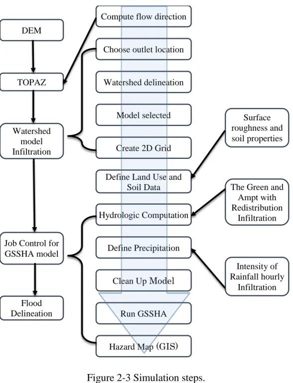
FIGURE 2-3SIMULATION STEPS... 36
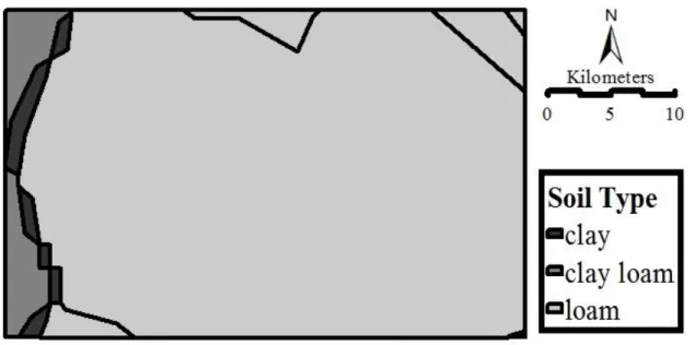
FIGURE 2-4MAP SHOWING SOIL TYPE. ... 38
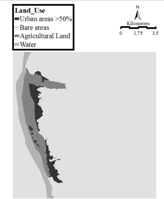
FIGURE 2-5MAP SHOWING LAND USE. ... 39
FIGURE 2-6SURFACE ROUGHNESS VALUES. ... 40
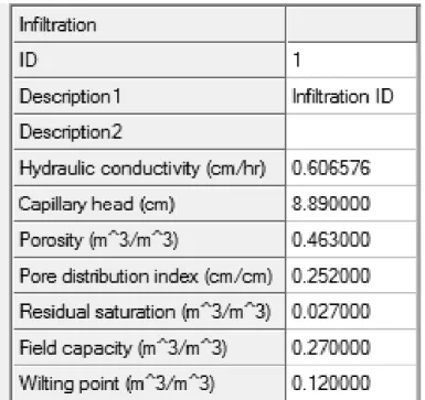
FIGURE 2-7INFILTRATION VALUES. ... 41
FIGURE 2-8INITIAL MOISTURE VALUES. ... 42
FIGURE 2-9 LOW LEVEL CONTOUR UNDER RISK OF TORRENTS ... 44
FIGURE 2-10THREE PARTS FROM THE URBAN AREA LOCATED IN RISK AREA ... 45
FIGURE 2-11WATERSHEDS DIVIDED THE URBAN AREA TO TWO GROUPS. ... 47
FIGURE 2-12THE WATERSHED WITH STREAM DRAIN. ... 48
FIGURE 2-13CONTOUR LINES FOR HAZARD DEPTH. ... 50
FIGURE 2-14URBAN AREA HAZARD DISTRIBUTION. ... 50
FIGURE 3-1UNDERLYING UGPM ALGORITHMS SORTED BY POPULARITY (PERCENTAGE OF 156 MANUSCRIPTS, A MANUSCRIPT MAY CONTAIN MULTIPLE ALGORITHMS).[69] .... 68
FIGURE 3-2THE STUDY AREA IN RELATION TO EGYPT AND THE WORLD. ... 70
FIGURE 3-3BUILDINGS WERE DESTROYED IN ABOUELREESH VILLAGE AFTER A TORRENT IN 2010. ... 72
FIGURE 3-4ROADS AND BUILDINGS AFFECTED BY TORRENTS IN EGYPT. ... 73
FIGURE 3-5.PREDICT THE FUTURE URBAN SPRAWL WORKFLOW ... 78
FIGURE 3-6DIGITAL ELEVATION MODEL FILE FOR THE CASE STUDY AREA. ... 82
L i s t o f F i g u r e s
XIII
FIGURE 3-7.THE STUDY AREA RELATED THE WORLD. ... 83
FIGURE 3-8URBAN AREA IN 2001 AND 2013. ... 85
FIGURE 3-9.CHANGING IN LAND USE BETWEEN 2001 AND 2013... 86
FIGURE 3-10. TRANSITION OF LAND USE. ... 88
FIGURE 3-11URBAN SPRAWL OVER THE YEARS. ... 91
FIGURE 3-12URBANIZATION IN EACH YEAR ... 93
FIGURE 3-13LAND USE CATEGORIES ... 93
FIGURE 3-14 THE AMOUNT OF URBAN GROWTH EACH YEAR AND THE PERCENTAGE INCREASE IN URBAN AREAS ... 93
FIGURE 3-15ANNUAL RATE OF INCREASE IN DEVELOPED URBAN AREAS ... 93
FIGURE 3-16.DRIVING FACTORS. ... 95
FIGURE 3-17CHANGING IN LAND USE BETWEEN 2001 AND 2009... 99
FIGURE 3-18. TRANSITION OF LAND USE BETWEEN 2001-2009. ... 101
FIGURE 3-19THE INCREASE OF URBAN AREA 2013-2037 ... 105
FIGURE 3-20 THE TOTAL PREDICTED URBAN AREAS 2013-2037. ... 106
FIGURE 4-1.BUILDINGS ARE DESTROYED IN ABOUELREESH VILLAGE AFTER A TORRENT IN 2010. ... 122
FIGURE 4-2.ROADS AND BUILDINGS AFFECTED BY TORRENTS IN EGYPT. ... 123
FIGURE 4-3DIGITAL ELEVATION MODEL FILE FOR THE CASE STUDY AREA. ... 125
FIGURE 4-4CONTOUR LINES FOR HAZARD DEPTH. ... 127
FIGURE 4-5URBAN AREA CLASSIFICATION. ... 129
FIGURE 4-6URBAN SPRAWL OVER THE YEARS ... 129
FIGURE 4-7PROPORTION OF SAFE AND RISK AREAS DEVELOPED ACCORDING TO YEAR .. 130
FIGURE 4-8ANNUAL RATE OF INCREASE IN DEVELOPED SAFE AND RISK AREAS... 131
C H A P T E R O N E
I N T R O D U C T I O N
1
Chapter 1
Introduction
1.1 Background and Statement of the Problem
We are recognizing that “Many Arab cities and towns are located in high risk areas, including coasts and highly seismic zones as well as volcanic areas making them exposed to disaster risks from earthquakes, flooding, flash flooding and storms leading to losses in lives, assets and livelihoods.”[1].
This is one of the most important sentences expression of the natural environmental disasters situation in Middle East and their impact on urban areas, especially when we know who said that. They were the Mayors and Local Government representatives together with National Government Officials in 1st Arab Conference for Disaster Risk Reduction, 19-21 March 2013 in Aqaba, Jordan.
C h a p t e r 1
2 1.1.1 Natural Environmental Disaster
Natural hazards are a naturally happening event that might have a harmful effect on people or the environment, which are initiated because of natural phenomena. Examples of natural hazards are typhoons, tsunamis, earthquake, volcanic, Landslides, floods [2]. Natural hazards is natural progression or phenomenon that may cause loss of life, harm or other health effects, property injury, loss of livings and services, social and economic trouble, or environmental damage [3]. While the Disasters are regularly defined as a result from the mixture of hazard, vulnerability and insufficient volume or measures to reduce the probable chances of risk. A disaster happens when a hazard influences on the vulnerable population and reasons damage, casualties and disruption [4].
In brief we can consider that when the natural hazard caused loss of life, injury, disease and other negative effects on human physical, together with damage to property, destruction of assets, loss of services, and environmental degradation in that case it is called Natural Environmental Disasters.
The world has witnessed a frightening increase in the frequency and harshness of disasters, with 240 million people on average being pretentious by natural disasters universal each year between 2000 and 2005. In 2007 alone, 414 natural disasters were informed, killing 16847 persons, harming or displacing more than 211 million others, and affecting damage estimated at over 74.9 US$ billion [5]. In 2014, the number of stated disasters confirmed the worldwide upward trend in natural disaster incidence. This trend is mostly driven by the increase in the amount of reported hydro- meteorological disasters. Hydrological (essentially floods) and meteorological (storms) disasters are the main contributors to this pattern. In
3
latest decades, the amount of reported hydrological disasters had been growing by 7.4% annually on average [5].
The amount of people that have been affected by natural disasters from 1975 to 2000 by income and disaster category as observed in Figure 1-1 [6]. Further than 95% of all deaths as a consequence of natural disasters are in the slightest developed nations, and these same countries have the greatest number of persons affected by natural disasters. Flooding is the single utmost destructive category of natural disaster that attacks humans and their livelihoods in all world [6].
Figure 1-1 World overview from 1975-2000 of number of people affected categorized by income class and disaster type.
A flash flood is, in brief, a sudden local flood of great volume and short period which follows within a few (generally less than six) hours of heavy or moderate rainfall [4]. Flash floods are regularly characterized by raging torrents afterward heavy rains that rip through river beds, urban roads,
C h a p t e r 1
4
or mountain valleys, sweeping all thing before them [7]. The phenomenon of the flash flood is one of the furthermost difficult natural disasters to predict in relations of time and place of occurrence [4].
During a flash flood there is a sudden increase in the water level in rivers and drains, and flow speed can be very high; the power of the water can be so countless as to tear away boulders, displace trees, and destroy bridges and constructions that stand in its way. Hence, flash floods present a thoughtful threat to lives and property [4]. As an outcome, it is challenging for the concerned authorities and groups to respond appropriately; active response plans are indispensable tools to lessen the danger of flash floods.
Between 1980 and 2008, further than 37 million persons were affected by lack, earthquakes, flash and other floods and storms and the losses to Arab economy were estimated at around US$ 20 billion [8]; Flood risk is cumulative in towns across the region (Arab Countries) because of real surfaces that do not engross water, inadequate or clogging of stream systems and the increased structure in lowland areas in floodplains [9].
Egypt is subject to a crowd of different types of crises/ disasters such as those: subsequent from natural disasters, environment pollution and neglect in areas such as transport accidents (cars, ships, aircrafts and trains).
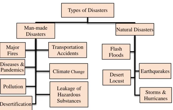
These disasters can be divided into two kinds: Natural Disasters and Man- made Disasters. Figure 1-2 shows the classification of the furthermost important disasters that Egypt expression (actual and potential). It covers together natural and man-made disasters [10].
5
Figure 1-2 The most common types of man-made and natural disasters occurred in Egypt.
Egypt is subject to so many natural disasters initiating main human and financial losses. The following table (Table 1-1) introduces a number of statistics on losses resulting from natural disasters which Egypt experienced during the period 1987-2008 [10].
Table 1-1 Losses occurred due to natural disasters in Egypt in (1987-2008).
Number of disasters 20
Number of deaths 1469
Annual average deaths 67
Number of victims 259,324 persons
Annual average of victims 11,787 persons
Financial losses US$ 1,342,000
Annual average financial losses US$ 61 million Types of Disasters
Man-made Disasters Major
Fires
Transportation Accidents Diseases &
Pandemics ClimateChange
Pollution Leakage of
Hazardous Substances Desertification
Natural Disasters
Flash Floods
Earthqueakes Desert
Locust
Storms &
Hurricanes
C h a p t e r 1
6
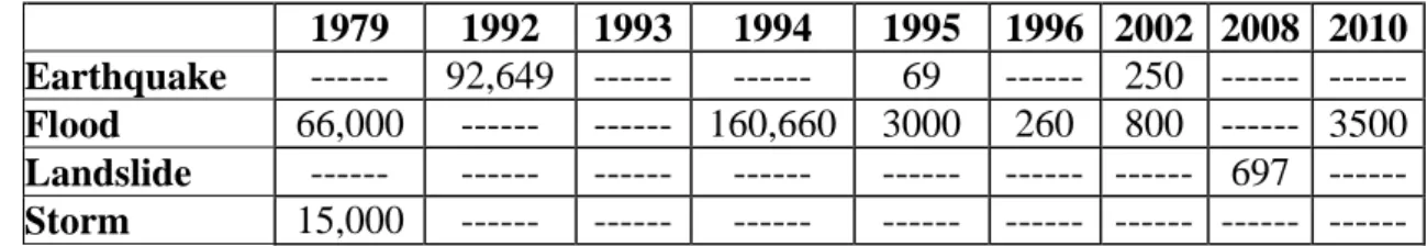
Egypt is positioned in the global belt of hot dry desert land with scarce rains. The Eastern desert has a network of intertwined olden valleys. When water exceeds the level of fullness in these deserts, it concentrates in the valleys and decants either into the Red Sea or the Nile Valley. Geographic topographies assist in giving water a drive to destroy anything in its way [10, 11]. Occasionally, heavy rains regularly result in flash floods in Egypt. Rain- made floods wash away property, claim exists and displace people. Flooding on January 18, 2010, for instance, affected over 3500 persons and claimed 12 lives, while a similar flood in 1994 affected over 160,000 persons as shown in Table 1-2 [11, 12].
Table 1-2 Number of people affected by natural hazards in Egypt.
1979 1992 1993 1994 1995 1996 2002 2008 2010 Earthquake --- 92,649 --- --- 69 --- 250 --- --- Flood 66,000 --- --- 160,660 3000 260 800 --- 3500 Landslide --- --- --- --- --- --- --- 697 --- Storm 15,000 --- --- --- --- --- --- --- ---
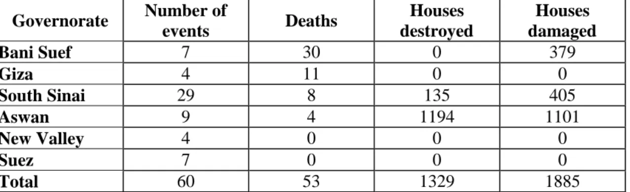
Egypt has also suffered after periodic flash floods in the Sinai Peninsula, and the districts of the Red-Sea port of Hurghada and Aswan [13]. Torrential rains as high as 20 mm/ day over Sainte Catherine on October 18, 1997 and comparable amounts in Al Qusseir, Ras Benas, Ras El Naqb and Aswan on the same time, led to very severe floods [11]. Table 1-3 shows the impact of the natural disasters in different cities [14].
7
Table 1-3 Distribution of disasters, damages and losses in Egypt by province.
Governorate Number of
events Deaths Houses
destroyed
Houses damaged
Bani Suef 7 30 0 379
Giza 4 11 0 0
South Sinai 29 8 135 405
Aswan 9 4 1194 1101
New Valley 4 0 0 0
Suez 7 0 0 0
Total 60 53 1329 1885
1.1.2 Risk Management
Risk is defined as the probable losses (of lives, peoples injured, property injured, and disruption of financial activities) due to a particular danger for a given area and reference period [15].
Disaster risk management is worried with putting the institutional and organization mechanisms in place to evade, lessen or transfer the adverse effects of dangers through activities and procedures for prevention, mitigation and preparedness [16].
A change to active management of natural disasters needs an identification of the risk, the improvement of strategies to reduce that risk, and the making of policies and programs to set these strategies into effect.
Risk management is a major activity geared to the evaluation of systems for reducing but not essentially eliminating the total risk, as in many cases risk cannot be completely eliminated [6].
C h a p t e r 1
8
Flood disaster management is an end-to-end process for distinguishing and effectively combating the risk connected with floods through a suite of planned activities. The process includes a number of activities that occur throughout the cycle: [6].
Pre-disaster - preventative measures and preparedness;
During the flood - disaster relief, response and mitigate actions; and
Post disaster - rehabilitation, reconstruction, economic recovery, and efforts to assess and fine-tune preventative measures.
This research focuses in the first activity which how to prepare the Pre-disaster step about preventative measures and preparedness, by simulate the natural disaster and identify the risk area before it acted .
Arab Region synthesis report denote to the weakness management of disaster risk by reference that Several Arab countries face institutional and management challenges, These management challenges include lack of technical skills, relevant experience, and human, logistical and financial funds to plan and implement disaster risk reduction measures [9].
Also the previews report denote to the lack of data, information, and mapping tools on susceptibility, danger exposure and risk add to the challenges facing effective disaster risk management is central factor that weaken effective application of DRR plans and activities [9].
9
The Sendai Framework for Disaster Risk Reduction 2015-2030 recommend in his final report that. To achieve Understanding disaster risk it is important: [17].
To develop, occasionally update and disseminate, as appropriate, location-based disaster risk information, including risk maps, to decision makers, the common public and communities at risk of exposure to disaster in an appropriate format by using, as applicable, geospatial information technology.
To promote real time access to dependable data, make use of space and in situ information, including geographic information systems (GIS), and use information and communications technology innovations to enhance measurement tools and the collection, analysis and dissemination of data.
1.1.3 Risky Urban Area Sprawl
City landscapes have been rapidly changing in the last few years in response to faster population growth and the transition from rural to urban areas [18]. According to United Nations reports, urban population will rise by 1.35 billion by 2030, at which period the population in urban areas in the world will be around 5 billion. It is prediction that worldwide urban land will increase by 1.2 million km2 by 2030, which will be closely triple the global urban land area circa 2000 [19].
Urban sprawl, a serious problem for many quickly developing countries, refers to the uncontrolled sprawl of an urban area resulting from poorly or totally unplanned urbanization [20]. The encroachment of urban land uses on non-urban land has become a common phenomenon throughout developing countries [21].
C h a p t e r 1
10
By the 1970s, urban sprawl was not only gotten as an incompetent pattern of urbanization but also as a phenomenon that injured inner cities, and consequently it had to be brought under stricter control [22]. The beginning of the 21st century saw urban population attainment a milestone when census showed that half of the world’s population exist in in cities [19].
Furthermore, urban areas have a natural extension in multiple directions, sometimes with growth even heading towards places prone to natural disasters. Hence, decision-makers and planners should mitigate this problem through risk management and by providing different replacements.
Additionally, high risk locations include urban areas, from pavement to tops where there is a concentration of rainfall runoff [23].
Cities are gradually more exposed to a variety of natural and manmade hazards including lacks, floods, earthquakes, storms and Torrents.
The potential for a hazard to become a disaster depends on the grade of exposure of a population and its physical or financial assets. Urbanization, immigration, population growth and economic increase are all factors that increase the attentiveness of people and assets in high risk areas. The higher grade of exposure and vulnerability of both people and infrastructure inside towns is a powerful cause behind why natural hazards tend to have larger social and economic impact in urban areas than in rustic areas.
Therefore, it is very important to manage the Risk of Natural Disasters such as Earthquakes and Torrents in sprawl of urban areas and make classification for main affective factors to try to control and direct the growth of cities to save it from the Risk of Natural Disasters.
Urban risk is a main concern in the region as big urban middles and mega cities are loaded by extreme poverty, slums, poor districts, joblessness,
11
and lack of basic services. Several urban areas, and not only the poor ones, are located in regions of high risk and are vulnerable to destruction from floods, earthquakes, landslides and snowstorms [9].
Urban planning and design has a key part to play in defining the pliability of a city or urban area. While the planning procedure and design requires vision, participation, suitable knowledge and information on present and future risks, the implementation and capacities to provide for safe area and main services to all urban residents requires political leadership backed up by solid policy decisions and investments. This is one of today’s foremost challenges in rapid urban sprawling contexts such as in Africa, Asia and Latin America [24].
Land use control will decrease danger of life and property when waters overwhelm the floodplains and the coastal areas. The number of casualties is connected to the population in the area at risk. In areas where people already have constructed their settlements, actions should be taken to relocate to better sites so as to decrease vulnerability. No main development should be allowable in the areas which are subjected to high flooding.
Important services like hospitals, schools should be constructed in safe areas.
In urban areas, water holding areas can be created like ponds, lakes or lowland areas.
Egypt has to contend with the problems caused by urban sprawl. For the earlier five decades, there has been an unprecedented sprawl process despite the government’s efforts to slow it down. While only fewer than 10%
of the current total population lived in cities at the opening of the 20th century, the urban population rose by 45 % by the finish of the century.
C h a p t e r 1
12 1.2 Purpose and Importance of the Study
Based on the recommendations from two of most important meeting has been holed in Middle East for National Government Officials about Disaster Risk Reduction, the first one is the 1st Arab Conference for Disaster Risk Reduction, 19-21 March 2013 in Aqaba, Jordan, the second one is 2nd Arab Conference on Disaster Risk Reduction, 14-16 September 2014 in Sharm El Sheikh, Egypt. We can observed many of important points that give impression about the orientation of Government Officials in Middle East about the disaster risk management, it can be mentioned in the following points:
The importance of the absence of database and information in disaster risk management, they mentioned that “Disaster losses are compounded due to the lack of a database and updated information on risk exposure in the Arab region” [8].
It is very needed to build or restore at least two infrastructure facilities to reduce disaster risks such as a dam or a flood drainage system.
They were referring to the urban sprawl in Arab country and its affect in risk management for natural disasters “Rapid urbanization in the Arab region constitute challenges that have negatively impact the capacity of Arab States to reduce and manage disaster risk.” [8].
Until the end of 2017, they attempt to prepare at least one disasters risk assessment report of the city to lead urban development plans and decisions, and ensure that this information and the plans for city’s resilience are readily available to the public [1].
Focus on scientific research and the promotion of technical means to assess risk, monitor and develop hazard maps, analyses vulnerability
13
using GIS and remote sensing tools, and enhance national risk assessment capacities [8].
This research takes advantage of the recommendations and observations of the 1st and 2nd Arab Conference for Disaster Risk Reduction about three point have big value in risk management of natural disasters.
First one is the importance of identifying the area of risk exposure by monitor and develop hazard maps, especially studying the flooding as a one of most hazardous natural hazards. The second point is the value of Urban Sprawl when manage the risk of natural disaster, how we can protect the urban area from expands to risks prone areas. The last point is the importance of the database and how much is the lack of data will be negatively impact on manage disaster risk process also the database and disaster information have to be available to the public and easy access
1.3 Research Objectives and Questions
The purpose of this research study will be to find easy and free access sources method to identify the risk prone areas from the torrents as a one of most effective natural environmental disasters, Moreover understanding of urban area expanding for this risk area by analysis the driving forces of urban sprawl in Aswan. This issue try to help the decision makers and planners in non-development countries which do not have enough data to complete the risk management procedures and plans.
In order to realize this, the specific objectives are:
To determine different methods can help in identifying the risk area which it was prone by torrents these methods can gives easy and fast tool to identify the risk area from natural
C h a p t e r 1
14
environmental disasters as a very important step in disasters risk management.
To identify torrents simulation model uses free and easy access data in generate primary results close to real live situations. It is necessary to perform simulations of the potential site to avert the threat of natural disasters.
To describe simple and plain methodology to determine the approximate periods for buildings that have been where construction by using manual photo-interpretation from satellite imagery. This methodology will be very useful in determine the urban sprawl.
To extract the driving factors that can led the urban sprawl to try understanding the expansion of urban area, and helping the decision-makers and planners to expect the urban growth in future.
To estimate the future urban area situation by identify fast and easy method to expecting the future urban sprawl that will help the government officials in estimate the expanding of urban area in risk area porn to natural disasters.
Based on the above objectives, there are four major emerging research questions the ability of implementation of the research aims about management the risk came from the natural disasters on urban areas, A key requirement to understand and achievement the research objectives by answering the following questions:
1- What is the convenient and easy method that can identify the risk area was prone to natural environmental disaster such as Torrents?
15
2- What is the proper way to simulate the torrents by using free and reachable data in the same time can generate primary results close to real live situations?
3- Is it possible to get simple methodology can gives approximate periods for buildings that have been where construction by using manual photo-interpretation from satellite imagery?
4- How can the research method extract the driving factors that can led the urban sprawl to expand in risk area porn to natural disasters and how we can estimate and expect the future urban area situation?
1.4 Framework of the Research
The thesis structure consists of five chapters describe the sequence of steps to achievement of the research objectives. Starting with the introduction which draw the statement of the research problem and the overview about the thesis logical processes, the second step was the body of research which include three parts describe in first one the method of identifying the risk areas from the Natural Disaster (Torrents), then shows how it can be study the growth of urban area from past to future, the last part contain to the analyses and predict the urban sprawl in torrents risk areas especially in case study area (Aswan City), In final of structure the thesis conclude the results of the research steps and give small issue about the future work.
In the following point the research will give a brief description about the chapters:
Chapter 1: This part describes the background of three main definitions, first the natural environmental disasters in the world specifically
C h a p t e r 1
16
shows the impact of torrents and flooding, the second one is some definitions about risk and disaster risk management especially the mean of flood disasters managements in Arab Region, further this chapter describes the importance of this study and what is the research objectives which the methodology have to achieve it, In the end of chapter there is the skeleton of the research thesis.
Chapter 2: This chapter suggest uses two method to identify the risk area comes from the natural disaster (Torrents), first one using ArcGIS - Hydrology Tools to delineate the watersheds and stream drain, the second method that the research uses GSSHA model to simulate the torrents in study case area. Those methods has many benefits especially for planners and decision makers in development countries, the first one those methods are very easy access and common use by very famous software such as ArcGIS, Second benefit is all data which used in this part is free data.
Chapter 3: This section analyses the past urban growth based on the study of the region in different time periods and identifies urban growth by a visual analysis of high-resolution aerial historical images of the city in Google Earth. Furthermore extract the driving factors that can led the urban sprawl using Land Change Modeler in IDRISI®Selva software, this method is very useful to try understanding the expansion of urban area. Moreover this chapter try to estimate the future urban sprawl by using method depend on the Logistic regression and Markov Chain Model.
Chapter 4: This chapter aims to identify the risk areas affected by torrents in the case study area and to investigate the relationship between the risk areas and urban sprawl. Using the WMS software, the collected data would be used to simulate the torrent and runoff water so that risk areas could be identified. Moreover the simulation method using WMS software was the
17
more accurate method because the take in account many kind of data source such as soil type map, land use map and the rain precipitation so that in this chapter will use this method to identify the risk area in case study.
Chapter 5: This is the last chapter in this thesis that contain the two important parts, first part summaries all results of this research and explain the ability of this results to achieve the objectives of the research such as the ability of research method could identify the risk area from the natural disasters also the situation of urban sprawl in past and future, the second part suggests some of ideas to how could this research be useful for the future work moreover suggests process to develop the research method be helpful to decision makers and planners in non-development countries.
C h a p t e r 1
18 1.5 References
[1] A. S. E. Z. A. (ASEZA), "Aqaba Declaration on Disaster Risk Reduction in Cities," United Nations International Strategy for Disaster Reduction (UNISDR), Aqaba,JORDAN2013.
[2] R. B. S. Balaka Dey, "Natural Hazards and Disaster Management,"
Central Board of Secondary Education, Delhi2006.
[3] UNISDR, "Terminology," ed: The United Nation Office for Disaster Risk Reduction, 2007.
[4] A. P. o. F. Management. (2014, Guidance on Flash Flood - Recent Experiences from Central and Eastern Europe. Available:
http://www.apfm.info/projects/pilot/europe/Pilot_Guidance_on_Flas h_Flood_Mgmt_Eastern_Europe.pdf
[5] S. J-M. , l. P. d. W. O. , B. R. , and G.-S. D. , "Annua Disaster Statistical Review," http://www.unisdr.org/2007.
[6] P. J. Pilon, "Guidelines for reducing flood losses," United Nations International Strategy for Disaster Reduction (UNISDR)1998.
[7] N. W. S. W. F. Office, "Definitions of flood and flash flood," ed:
National Weather Service.
[8] S. A. Conference, "Sharm El Sheikh Declaration on Disaster Risk Reduction," United Nations International Strategy for Disaster Reduction (UNISDR), Sharm El Sheikh, Egypt2014.
[9] F. El-Mallah, "Arab Region synthesis report: Consultations on the post - 2015 framework for disaster risk reduction," United Nations International Strategy for Disaster Reduction (UNISDR)2015.
[10] t. A. C. f. C. D. M. a. D. R. Reduction, "National Strategy For Crisis/
Disaster Management And Disaster Risk Reduction,"
http://www.preventionweb.net/, Cairo2010.
[11] A. C. f. C. D. M. a. D. R. Reduction, "National Strategy For Crisis/
Disaster Management And Disaster Risk Reduction "
http://www.preventionweb.net/, Cairo2010.
[12] W. Bank, "Egypt Dashboard," ed: World Bank Group, 2015.
[13] U. N. O. f. D. R. Reduction, "UNISDR," ed: United Nations Office fro Disaster Risk Reduction, 2014.
[14] H. Ezzine, "Regional Analysis of Disaster Loss Databases in Arav States," United Nations International Strategy for Disaster Reduction (UNISDR), Cairo, Egypt2015.
[15] C. J. v. Westen, L. Montoya, and L. Boerboom. (2002). MULTI- HAZARD RISK ASSESSMENT USING GIS IN URBAN AREAS: A CASE STUDY FOR THE CITY OF TURRIALBA, COSTA RICA.
[16] K. Westgate, "Toolkit for National Platforms for Disaster Risk Reduction in Africa: Contributing to the implementation of the Hyogo Framework for Action (HFA) and the Africa Regional Strategy and Programme of Action for DRR," United Nations International Strategy for Disaster Reduction (UNISDR)2010.