Detection of a climatological short break in the Polar Night Jet in early winter and its relation to cooling over Siberia
Yuta Ando1, 2, Koji Yamazaki3, Yoshihiro Tachibana1, Masayo Ogi3, and Jinro Ukita2
1Weather and Climate Dynamics Division, Mie University
2Faculty of Science, Niigata University
3Hokkaido University
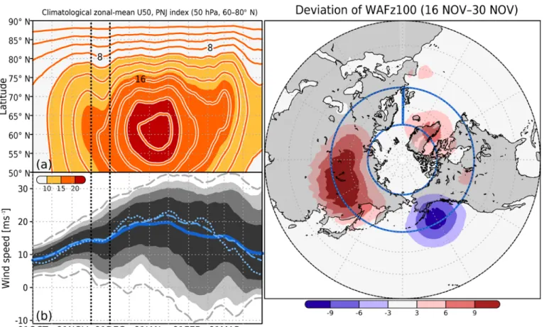
The Polar Night Jet (PNJ) is a strong westerly circumpolar wind at around 65°N in the stratosphere in winter, and the strength of the climatological PNJ is widely recognized to increase monotonically from October through late December. Remarkably, the climatological PNJ temporarily stops increasing during late November (Figures 1a and 1b). We examined this short break in terms of the atmospheric dynamical balance and found that it results from an increase in the upward propagation of climatological planetary waves from the troposphere to the stratosphere in late November that coincides with a maximum of the climatological Eliassen-Palm flux convergence in the lower stratosphere. The upward propagation of planetary waves, which is strongest at 100 hPa over Siberia, is related to the climatological strengthening of the tropospheric trough over Siberia (Figure 1c). We suggest that longitudinally asymmetric forcing by land–sea heating contrasts caused by their different heat capacities can account for the strengthening of the trough.
Figure 1 (a) Latitude–time cross section of the 15-day running mean of the climatological zonal-mean zonal wind at 50 hPa (U�50; lines and color shading) from 1 October through 31 March. The contour interval is 2.0 m s–1. (b) Time series of the climatological 15-day running mean of the Polar Night Jet (PNJ) index (m s–1, blue), defined as zonal-mean zonal wind speed at 65°N and 50 hPa. Dark gray shading indicates the 20th to 80th percentiles, medium gray shading indicates the 10th to 90th percentiles, and light gray shading indicates the 5th to 95th percentiles. The two dashed lines indicated the daily minimum and maximum of the PNJ. The vertical black dotted lines indicate the period of the short break in late November. (c) Vertical component of the late November deviation of the climatological wave activity flux (Plumb, 1985) at 100 hPa (10−3 m2 s−2) with respect to its sinusoidal seasonal evolution
Reference
Ando, Y., K. Yamazaki, Y. Tachibana, M. Ogi, and J. Ukita: Detection of a climatological short break in the polar night jet in early winter and its relation to cooling over Siberia, Atmos. Chem. Phys., 18, 12639–12661, https://doi.org/10.5194/acp-18- 12639-2018, 2018.