TUMSAT-OACIS Repository - Tokyo University of Marine Science and Technology (東京海洋大学)
The effectiveness of vessel monitoring system
in Fiji fisheries waters and areas beyond
national jurisdiction(フィジー漁業水域及び国
家管轄外域における船舶監視システムの有効性につ
いて)
学位名
修士(海洋科学)
学位授与機関
東京海洋大学
学位授与年度
2019
URL
http://id.nii.ac.jp/1342/00001888/
Master’s Thesis
THE EFFECTIVENESS OF VESSEL MONITORING SYSTEM IN FIJI FISHERIES WATERS AND AREAS BEYOND NATIONAL JURISDICTION
March 2020
Graduate School of Marine Science and Technology
Tokyo University of Marine Science and Technology
Master’s Course of Marine Policy and Management
i
DEDICATION
To my greatest assests, my inspiration and my blessings – my husband, Aminiasi and my beautiful children - Sakiusa, Sanaila, Aloesi, Ruth, Vasiti Lily-Ann and Makereta….This is for you.
ii
ACKNOWLEDGEMENT
First and foremost I would like to acknowledge and thank my Lord and Saviour for equipping me with the right amount of strength, knowledge and wisdom to conquer the hurdles that has not only been my setbacks but has become my motivation to complete my paper.
This paper would not have been possible without the assistance and valuable contribution of the following people;
• My Family - my Husband, for his never ending love and patience, my Parents, for their support and prayers and my families in Clifton (CIRIKIYASAWAs) and Nakasi (BAINIVALUs) for their encouragement and invaluable support.
• Professor Joji MORISHITA – My supervisor and sensei, for his wonderful guidance, expert advise and understanding
• The Japanese Government through the JICA PACIFC LEADS Scholarship – For the wonderful opportunity to study and experience life in Japan
• The Ministry of Fisheries, Fiji – For the approval to use Fisheries data and information (former Director Fisheries, Mr. Aisake Batibasaga for all his assistance) and Staff of the Offshore Fisheries Division – Mr. Jone Amoe, for the approval to use office space during my two research phases, Meli Raicebe, Leba Dranivesi, Apenisa Sauturaga, Shelvin Chand, Losalini Turaga, Arieta Tunidau, Raijeli Natadra, Sunia Duwai and Tevita Wereivalu, for the provision of fisheries statistics and other related fisheries information
• Mr. Anare Raiwalui – For his time in providing undocumented and useful information on VMS and the Offshore Fisheries
• Katsumi NAGAIKE – my tutor at the University and all my Studyroom mates of Building 8, Room 304 for their assistance and friendship
• Fiji Community, Japan – Mrs Sereana Tabuyaqona, Kelera Savu, Mr & Mrs Leone Gukirewa and Joy Kaloumaira – For their kindness, love and support
• Colleagues and Friends of P-LEADS (Batch 2) – Adilamawa Vesikula, Miliana Navia, Milika Ratu, Salanieta Matai and Ulamila Cakaunitabua – For their companionship and constructive comments on this paper
iii ABSTRACT
For proper monitoring and surveillance of Fiji fishing vessels operating in Fiji Fisheries waters and areas beyond national jurisdiction, the use of Vessel Monitoring System (VMS) is an effective means of tracking these vessels as it provides powerful source of information regarding fishing areas, fishing effort and the provision of reliable fishing statistics. In an attempt to verify the extent of effectiveness of VMS, certain fishing activities such as Catch logs, Landings summary, Transshipment, Bunkering, Notification of intentions and the Observer infringements reports will be discussed in this paper. The United Nations Convention on the Law of the Sea (UNCLOS) establishes a number of important principles relating to the conservation and management of marine resources both within national jurisdiction and the high seas. Though it does not specify the use or requirement of VMS, it gives the option to coastal states to explore Monitoring Control and Surveillance (MCS) initiatives that could be engaged to address the conservation and management aspects. International instruments that follow recognizes the timely collection and exchange of data and the need to design systems of data verification. Regional efforts have led to the coordination and introduction of VMS to better police the fishing related activities in the national jurisdictions of member states in its effort to combat Illegal, Unreported and Unregulated (IUU) fishing. This research has dictated the kinds of research methods enlisted to collect the relevant data and information needed for the timely compilation. There were two phases of research conducted of which the use of the following methodologies was used, In-depth qualitative interviewing, collation of Documents and Archival data and the Primary and Secondary research.
The analysis of data collected is a reflection of how effective VMS is for verifying the occurences of these fishing related activities in Fiji waters and areas beyond national jurisdiction.
iv
The verification of Catch logsheet with VMS data was to verify the position, speed, date, time and the legality of catch. For the purpose of this study, logsheet data from 2014-2018, was calculated at 45,252.59mt. Landings on the other hand is the number of catch that is actually landed, total landed catch from 2014-2018 was 75,007mt. Unreported catch, (mis-reported and non-reported) was recorded at 29,754.41mt, 39.6% less of what was actually landed. The analysis of Observer Infringements, included selected ones that could be verified with VMS. It was noted that from 2014-2018, 93.3% of the infringements was committed by vessels fishing in the Exclusive Economic Zone (EEZ) and High Seas. For infringements such as fishing in areas not permitted to fish, this was committed by 13% of vessels fishing in the EEZ and High Seas and 30% by those fishing in the Archipelagic Waters (AW) and Territorial Sea (TS). For transshipment and bunkering, 80.3% of these fishing activities occurred in the EEZ and HighSeas and 60% occurred in the AWand TS. Other Infringements were minimal in occurance throughout the five years and was issued with a warning to avoid similar offence in future.
Furthermore, Fixed Penalty Notices (FPN) that was issued as a violation to Regulation 39(2)(b) of failing to notify at least 48hours prior to entry into and departure from Fiji fisheries waters (Zone Entry and Exit) was verified and confirmed by VMS data for vessels violating this regulation. In 2016, 25% of FPN was issued for the offence, 33% was issued in 2017 and 40% was issued in 2018 for the same. For failing to notify a Port State at least 24hrs prior to the estimated time of entry into any port in Fiji [Regulation 39(2)(e)]. This was verified with VMS data and information to confirm the offence. In 2016, 75% of FPN was issued, 2017, 67% and in 2018, 60% was issued for the same offence.
The issuance of FPN against a person or offence committed under the OFMA, is a testament of Fiji’s commitment to its international and regional obligation in the fight to prevent,
v
deter and eliminate Illegal, Unreported and Unregulated fishing. VMS provides relatively reliable and accurate information on the location of vessels and with a reasonable degree of probability of where the fishing activity takes place. Nevertheless, it can enhance the monitoring, control and surveillance of fisheries in a cost-effective manner.
vi TABLE OF CONTENTS Page DEDICATION………..i ACKNOWLEDGEMENT………ii ABSTRACT……….iii TABLE OF CONTETS………vi LIST OF TABLES………..viii LIST OF FIGURES………..x ACRONYMS………xi CHAPTER 1: INTRODUCTION 1.1 Background Study………..1
1.2 Objectives of the Study………...3
1.3 Significance of this Study………...5
1.4 Structure of this paper……….5
1.5 Historical Development of VMS………6
1.6.1 The Regional VMS……….7
1.6.2 VMS in Fiji………..9
1.7 Institutional and Legal Framework………11
1.8 Traditional and Conventional MCS Methods……….12
CHAPTER 2: LITERATURE REVIEW 2.1 Overview………..18
2.2 Potential uses of VMS………..20
2.3 Value of VMS………...22
CHAPTER 3: METHODOLOGY 3.1 Overview of Research Process……….24
vii
3.2 Qualitative Research………25
3.3 Quantitative Research……….30
3.3.1 Collection of Data and Information through Primary Research………31
3.3.2 Collection of Data and Information through Secondary Research………33
3.4 Data Processing and Analysis……….33
CHAPTER 4: RESULTS AND DISCUSSION 4.1 Landings and Logsheet data………35
4.2 Fisheries Observer Infringements and Violations………37
4.3 Zone and Port Entry and Exit Notification………..43
CHAPTER 5: CONCLUSION 5.1 Effectiveness and Limitations of VMS………46
5.2 Limitations of the Study………47
5.3 Recommendations………47
5.4 Future Study………48
REFERENCES……….50
APPENDICES………..54
1. Senior Management Organizational Structure for Ministry of Fisheries………54
2. Organisational Structure for Offshore Service Centre………55
3. Article 64 and Article 54 of UNCLOS………...56
4. Regulation 34(2)(b) on Transhipment and Regulation 35(2)(b) on Bunkering of the OFMR (2014)………..………58
5. Transhipment Authorisation Form (Schedule 6I) of the OFMR (2014).…..….………. 60
viii
7. Regulation 39(2)(b) and Regulation 39(2)(e) on Vessel Reporting Requirements of the OFMR(2014)……….….………..63 8. Vessel Reporting Requirements Form (Schedule 3A) of the OFMR (2014)……….…64
ix
LIST OF TABLES
Table 1.1 MCS Components and Year of Operation………14
Table 1.2 International Conventions and Agreements regulating Fiji’s Offshore
Fisheries……….16
Table 1.3 Regional Conventions, Treaties and Agreements regulating Fiji’s Offshore
Fisheries……….17
Table 1.4 National legislations and Management Plan regulating Fiji’s Offshore
Fisheries………..17
Table 3.1 Indepth Interview, List of personnel and their affiliations to the research and
information collected………..26
Table 3.2 Type of Qualitative documents and Archival data and information
Extracted……….30
Table 3.3 Data and information collected through Primary and Secondary Qualitative
Research………31
Table 4.1 Types of Infringements and degree of occurances recorded by
x
LIST OF FIGURES
Figure 1.1 Map of Fiji’s Exclusive Economic Zone………2
Figure 1.2 Map showing EEZ region of the WCPO………9
Figure 4.1 Annual Catch Estimates for the Fiji National Fleet (2014-2018)………35
Figure 4.2 Landings vs Logsheet Data and Under-reported/Mis-reported Catch………..36
Figure 4.3 Longline licenses and authourisation issued by flag from 2014-2018………38
Figure 4.4 Observer Coverage by Authourised Area……….39
Figure 4.5 Flow Chart of Procedural verification of Observer Infringments by VMS data By VMS data……….41
Figure 4.6 Flow Chart of Procedural verification of bunkering and transshipment ……….……….42
Figure 4.7 Procedural verification of Zone Entry and Exit Notification by VMS data………..43
Figure 4.8 Procedural verification of Port Entry and Exit Notification by VMS data………..44
xi
ACRONYMNS ALB - Albacore
ALC – Automatic Location Communicator AW – Archipelagic Waters
BET – Bigeye
CMMs – Conservation Management Measures DWFN – Distant Water Fishing Nation
EEZ – Exclusive Economic Zone ETA – Estimated Time of Arrival
FFA – Pacific Islands Forum Fisheries Agency FPN – Fixed Penalty Notice
IUU – Illegal Unreported and Unregulated MCS – Monitoring, Control and Surveillance OFMA – Offshore Fisheries Management Act
OFMR – Offshore Fisheries Management Regulation TS – Territorial Sea
UNCLOS – United Nations on the Law of the Sea Convention
UNFSA – United Nations Agreement for the Implementation of the Provisions of the United Nations Convention on the Law of the Sea (10 December 1982) Relating to the Conservation and Management of Straddling Fish Stocks and Highly Migratory Fish Stocks
UNODC – United Nations Office on Drugs and Crime VMS – Vessel Monitoring System
WCPO – Western Central Pacific Ocean
WCPFC – Western Central Pacific Fisheries Commission YFT – Yellowfin
1 CHAPTER 1 INTRODUCTION 1.1 Background Study
Fiji is a country in the South Pacific Ocean composed of 332 islands of which only 110 are inhabited and it has a tropical marine climate (Food & Agriculture Organisation of the United Nations [FAO], 2016) and a population of 884,887 (Ministry of Communications, 2019). It is located between 176° 53'E and 178° 12'W, and has a total land area of 18,274 square kilometers, and 1.29 million square kilometers of the ocean within its jurisdiction. The Exclusive Economic Zone (EEZ) borders five Pacific Island nations, Vanuatu to the west, the Solomon Islands to the north-west, Tuvalu in the north, Wallis and Futuna to the north-east and the Kingdom of Tonga to the south-east (Patterson, 2010).
Fiji is a democratically governed developing nation, and the government is operating on a Constitution adopted in 2013. Fish and fishing are extremely important to the economy of Fiji (FAO, 2020) as the former provides a staple supply of protein in the people’s diet and the latter contributes to revenue, employment, and a source of livelihood for many people in Fiji. According, to the Ministry of Fisheries (MoF), Annual Report, 2016-2017, the contribution of the fisheries sector to the economy GDP is 1.8%.
2
Figure 1.1 Map of Fiji’s Exclusive Economic Zone Source: Secretariat of the Pacific Community
With a growing emphasis centred on the fisheries sector and the value of its resources, the need for conservation and management as always been a government priority. The implementation of the various monitoring, control and surveillance (MCS) mechanisms reflects Fiji’s determination to ensure the sustainability of its marine resources. S.-K. Chang, 2011 believes that the implementations of a sophisticated VMS that recognizes and operationalizes its full potential will likely result in effective fisheries management and sustainable fishing practices. Over the years, as seen the progressive developments of these MCS tools for the prevention, detection, and elimination of IUU fishing. The common denominator here is the animal tuna, it is highly
3
migratory and is subject to moving, driven by ocean currents, changes in availability of their prey and other processes that vary naturally, the animal does not respect boundaries, so in theory if you want to track the fish/tuna you track the fishing vessels (D. Koroi, personal communication, March 5, 2019).
One of the MCS tools that will be discussed in great depth in this thesis is the VMS, a cost-effective satellite-based monitoring system which, at regular intervals, provides data to the fisheries authorities on the location, course, and speed of regulated or licensed fishing vessels. Discussed further into the paper (1.6.1 &1.6.2) is the VMS portals used for monitoring, reporting and verification purposes both on a regional and national platform.
1.2 Objectives of the Study
In an attempt to verify the extent of effectiveness of VMS through the objectives set herein; this paper will further deliberate through incidences of unauthourised fishing related activities to gage the effectiveness of VMS in verifying its occurances out at sea.
i. Landings and Catch Logs
ii. Transshipment – the unloading of all or any of the fish on board a fishing vessel to another fishing vessel either at sea or in port.
iii. Bunkering – the supplying of fuel for use by ships
iv. Observer infringements and violations –any non compliance to national, regional and international instruments sighted and recorded by observers while on deployment out at sea
v. Zone Entry and Exit notification report – the entry and exit of a fishing vessel into an EEZ or the crossing to or from an EEZ into or out of the High Seas.
4
vi. Port Entry and Exit notification report – the notification to enter and exit a port state to utilize its port services for landing, transshipping, packaging or processing of fish or for other port services including inter alia, refuelling and resupplying
The research will endeavor to;
• Identify unauthourised fishing related activities that can be verified with the use of VMS data and information
• Explore the limitations of VMS as a surveillance mechanism
• Suggest possible recommendations on addressing internal processes within Offshore Fisheries that best serve the interest of the effective use of VMS.
Research Questions
The following research questions will need to be addressed to achieve the objectives of the research. 1. What are the fishing related activities that warrant the use of VMS data and information
for verification purposes?
2. What are some of the limitations scope of VMS as a surveillance meachnism?
3. Suggest possible areas and recommenadations on how processes within Offshore Fisheries can be improved to best serve the objective of VMS
The first question will be addressed through the provision of landings and logsheet data, Infringements and violations recorded by Observers at sea, Entry and Exit Notifications, and Unauthorized and illegal fisheries activities such as transshipment and bunkering that can be verified by application of VMS data and information. These violations are conducted by licensed and authorized longline fishing vessels, fishing in Fiji fisheries waters and areas beyond national
5
jurisdiction. It will also look at uncertain observations during various fishing activities due to limitations presented by VMS information and data.
The second question will look at areas where the use of VMS is limited in terms of monitoring and surveillance of fishing vessels.
The third question will discuss limitations of study and suggest possible recommendations on how the internal processes within Offshore Fisheries can be best addressed to serve the best interest of VMS and its application as a MCS tool.
1.3 Significance of this Study
Over the past years, similar studies have been done on the use of VMS data and information to generate reports for scientific, management, and conservation purposes, but no reviews have been done specifically on the extent of effectiveness of VMS in Fiji fisheries waters and areas beyond national jurisdiction. This dissertation will highlight the circumstances and areas that have proved the effectiveness of VMS. My interest in studying and exploring the effectiveness of VMS is mainly due to the fact that Fiji has its own domestic longline fleet that is licensed, flagged, and based in Fiji. With a vast area of ocean under Fiji’s sovereignity and the need to appropriately manage its offshore marine resources, is of paramount importance to Fiji. More so, with over eighty vessels licensed to fish in Fiji’s waters and authourised to fish beyond the national limits, the need to effectively monitor fishing vessels carrying out fishing and fishing related activities out at sea warrants a good and reliable MCS tool to capture all this simple but powerful information.
1.4 Structure of this Study
The first chapter provides an introductory perspective on the background of VMS, the objective of this dissertation, the research questions that will be explored to achieve the goals set
6
herein, the significance and the structure of the paper. It also highlights the the historical development of VMS, the monitoring system used on a regional and national level, and the institutional and legal arrangements in place to support the administration of Fisheries in Fiji and national laws that regulate, conserve and manage Fiji’s marine resources.
Chapter II will look at the various definitions of keywords used in this dissertation and the sightings of related literature and the different potential of VMS that have been explored by other researchers to generate reports for the benefit of their respective studies.
Chapter III will introduce the various methods used to collect information and data and elaborate on the types of data collected from the said methods and also the processes involved in the analysis of information and data collected.
Chapter IV will seek to provide the analysis and discussion of the information and data collected so far to determine the findings of this dissertation.
The final chapter, Chapter V, will highlight and share concluding remarks based on the findings of this dissertation and also offer possible recommendations on how the use of VMS in Fiji Fisheries can be improved to better address other fisheries related violations and infringements.
1.5 Historical Development of VMS
The use of VMS in fisheries dates from the early 1990’s when the first trials were implemented in Australia, Canada, European Union (EU), New Zealand, and the USA (Cacaud, 1998). Despite the fact that most of the trials were still in their early stages and therefore their level of success or failures were still unclear, more countries expressed their interest at developing their own VMS at either the national or regional level. The concept of a satellite-based vessel monitoring system (VMS) for the use of Forum Fisheries Agency (FFA) member countries in their Exclusive
7
Economic Zones (EEZ) was under discussion in the mid-late 80s, as an example of non-traditional hardware that may be used in the function of fisheries surveillance (Aldous, 1986). The basis of this approach was because FFA member countries were becoming mindful of the value of such systems in improving compliance, surveillance, and data retrieval in the area of fisheries management. Technical consultations on fishing vessel monitoring systems were held on a regular basis to determine national and sub-regional VMS programs to promote the standardization and harmonization of VMS as it is introduced to the commercial tuna fleet operating in the Western Central Pacific Ocean(WCPO). O'Shea and Thompson, 2006 stresses that these systems also allow the flag state or coastal state to remotely monitor fishing vessel activity (vessel identification, geographical position, the date and time of the position, vessel course and speed) within certain geographical boundaries.
After the requirement for the regulation of VMS was put in place in 2002, the only capacity required in implementing such initiative at the national level was to have a dedicated trained VMS officer and an office to house a Personal Computer (PC). In Fiji, the Fiji Navy was selected along with a Fisheries officer, as our first trained officer who was allowed to access the VMS data by going down to the Naval base (A. Raiwalui, personal communication, September 25, 2018). As the Ministry of Fisheries, built its own capacity and with a dedicated officer, the Offshore Fisheries Division then accessed the VMS data direct from FFA through a given password.
1.6.1 The Regional VMS
The Pacific Islands Forum Fisheries Agency (FFA) coordinated and introduced the FFA VMS on 17 March, 1999 as a regional initiative to its members. It is an intergovernmental agency established on August 9th, 1979 to coordinate fisheries policies among island states and aid negotiation with Distant Water Fishing Nations (DWFNs) (DeMers and Kahui, 2012).
8
FAO, 1998 agrees that the success of VMS in the Pacific has resulted in the South Pacific Forum deciding to develop a sub regional system which, through the Forum Fisheries Agency (FFA), will serve the interests of the 16 member countries including many which are small, relatively poorly resourced and are classified as developing countries. FFA VMS provides a bird’s eye view of fishing activities in FFA member country’s Exclusive Economic Zone (EEZ), Closed Areas or even High Seas Pockets (D. Koroi, personal communication, March 3, 2019). Moreover, Cacaud, 1998 believes that for many small island nations, which derive susbstantial income from rights of access to their fisheries but do not have the adequate assets in personnel or equipment to enforce their fisheries regulations, VMS is a particularly attractive technological innovation, since it has the potential, at an affordable cost to improve the effectiveness of MCS schemes and by the same token secure a major sector of their economy.
In 2004, the Western Central Pacific Fisheries Commission (WCPFC) was established to manage tuna regionally. The WCPFC is responsible for ensuring the long- term sustainability of highly migratory fish stocks in the WCPO and the promotion of the optimum utilization of these stocks (DeMers and Kahui, 2012). In the effort to contribute to the objective of its establishment, the WCFC VMS came into operation in April, 2009. S.-K. Chang et al., 2010 highlights that, in the WCPFC Convention (Article 24) that each member of the Commission shall require its fishing vessels that fish for highly migratory fish stocks on the high seas in the Convention Area to use near real-time satellite position-fixing transmitters. All vessels fishing in the WCPO are required to maintain VMS transmission when they move into the part of the Convention Area bounded by 20°N and 175°E from elsewhere in the Convention area (WCPFC, 2019). The contracted system that provides VMS information to the FFA VMS and the WCPFC VMS system is referred to as
9
the “Pacific VMS”. The FFA and WCPFC VMS work in collaboration in the common effort to prevent, deter and eliminate IUU fishing and safe guard the interests of it members.
Figure 1.2 Map showing EEZs region of the WCPO
Source: © Alaska Sea Grant, University of Alaska Fairbanks
1.6.2 VMS in Fiji
In 2002, Fiji introduced regulations requiring the use of fishing vessel monitoring system to monitor the position and activities of fishing vessels in order to effectively manage its fisheries.The use of this tool is mandatory to all Fiji fishing vessels that are licensed to fish in Fiji fisheries waters and authourised in areas beyond Fiji fisheries waters, targeting highly migratory fish stocks in-zone and beyond our EEZ (L. Dranivesi, personal communication, October 15, 2018). The VMS relies on the installation of a device known as the Automatic Location Communicator(ALC) on the fishing vessel and satellites to transmit information back to the Forum
10
Fisheries Agency (FFA) and the licensing state (Manoa, 2006). The use of the FFA VMS is a requirement only to vessels that are twenty (20) meters and more in length and the validity of the use of this system is usually displayed through a FFA VMS Certificate which is renewed on a twelve (12) month basis depending on when the current certificate expires. The FFA VMS Registration year runs from 1 September in any year to 31 August in the following year (Richards, FFA Report 99/21). All fishing vessels requiring the use of VMS are to be installed only by the FFA approved service provider. The FFA sets the requirements for fishing vessels that report through the FFA VMS and determine the ALC units that are to be used for this purpose. Vessels licensed in Archipelagic waters (AW) and Territorial waters (TW) are exempted from using FFA VMS, however, they have their own VMS system which the Surveillance officer of the Ministry of Fisheries also has access to, for accountability of its fishing operations. Furthermore, all Fiji licensed and Fiji flagged fishing vessels that fish outside of Fiji waters are required to be on the Western Central Pacific Fisheries Commission (WCPFC) Record of Fishing Vessels (RFV) whereby their movement in the high seas is monitored by the Western Central Pacific Fisheries Commission (WCPFC) VMS.
Fiji currently enagages the use of two types of FFA VMS portals namely Trackwell and the Regional Information Management Facility (RIMF). The primary portal is Trackwell, RIMF feeds of Trackwell (D. Koroi, personal communication, January 6, 2020). Vessels that do not poll or report on these systems can be viewed on Automated Information System (AIS), however they are required by law to report every Wednesdays and on a four hourly basis until they return to port or at any time their VMS has been rectified. The Offshore Service Centre, (formely the Offshore Fisheries Division), has a dedicated Surveillance Officer, who monitors fishing activities of Fiji
11
fishing vessels fishing in our waters and areas beyond national jurisdiction and houses a server that is directly linked to the main MCS center in Honiara, Solomon Islands.
1.7 Institutional and Legal Framework
The Ministry of Fisheries, Fiji has the mandate to manage the country’s living marine resources (FAO, 2009). The office housing the Ministry of Fisheries, now known as the Fisheries Support Centre, is located in Toorak, Suva and provides administrative services through the Minister responsible for fisheries, the Permanent and Deputy Secretary of Fisheries and the office of the Director Fisheries. The management of the Coastal fisheries is handled by the four (4) regional offices around the country while the Aquaculture, Offshore, Inshore and Research divisions is supervised by the various Functional heads [See Appendix 1 for Senior Management Structure for Ministry of Fisheries].
The Offshore Fisheries Division is tasked to implement MCS initiatives at national level to prevent, deter and eliminate IUU fishing (Pramod, 2018). There are 53 appointed positions within the division that look after the Data Unit, Enforcement and Surveillane Unit, Licensing and Permitting Unit, Monitoring and the Industry and Trade Unit and a dedicated officer responsible for the administration and financial affairs of the division [See Appendix 2 for Organisational Structure for the Offshore Service Centre].
The regulation of commercial fisheries in Fiji only began in the 1940s after the enactment of the first fisheries ordinance (Manoa, 2006). The domestic Offshore Fishery commenced operation a little before the demarcation of the archipelagic waters (AW), territorial sea (TS), and exclusive economic zone (EEZ) at the International Agreement on maritime spaces during the Third United Nations Conference on the Law of the Sea in 1979. Prior to that, the Taiwanese and Japanese flagged fishing vessels that were operating in the Western Central Pacific Ocean(WCPO)
12
and were landing their catch at the then Japanese owned cannery at Levuka (A. Raiwalui, personal communication, September 25, 2018). The main commercial target species for Fiji’s longline industry, are albacore (Thunnus alalunga), yellowfin (Thunnus albacores), bigeye (Thunnus
obesus) and skipjack (Katsuwonus pelamis). A variety of other non-target species (by-catch),
some of considerable economic value, are also landed (Richards, FFA Report 99/21). The management of Offshore Fishery in Fiji is regulated under the Offshore Fisheries Management Act (OFMA), 2012, and its subsequent regulations (OFMR), 2014, and the Marine Spaces Act (Chapter 158 A). The OFMA and OFMR stipulates provisions for the management, development, and sustainable use of fisheries and living marine resources. The Marine Spaces Act (Chapter 158A) establishes the archipelagic waters of Fiji and a twelve nautical mile territorial sea. The Act also establishes a 200 nautical mile exclusive economic zone over which Fiji has sovereign rights for the purpose of exploring and exploiting, conserving and managing the natural resources of the seabed, subsoil and superjacent waters (FAO, 2009). Embedded in these national legislations are the international and regional commitments and obligations to Fiji as a coastal state, flag state and a port state. These Fisheries laws draws particular attention to the statutory and mandatory responsibilities of the Heads of Fisheries (Minister responsible for Fisheries, Permanent Secretary and the Director Fisheries). Moreover, also stipulated is the Licensing of Fiji fishing vessels,
boarding and inspection of vessels that berth in our designated fisheries ports, monitoring, control and surveillance of Fiji fishing vessels in our waters.
1.8 Traditional and Conventional MCS Methods
Anon, 1994 highlights that in complementing the use of VMS, FFA member countries have also adopted and implemented procedures such as air and sea surveillance in cooperation with
13
other island states, regional and observer programs, regional register of foreign fishing vessels and agreements in participation in surveillance between the FFA member countries. Established as a small navy squadron in 1978 with the main purpose of policing Fiji’s newly declared 200 mile EEZ (Tarte, 2010), the Fiji Navy is responsible for maritime needs in border control such as watching over Fiji’s EEZ and organizing task and rescue missions.
Fiji does not have adequate surveillance infrastructure such as patrol aircraft and patrol vessels and relies heavily on Australia, France, New Zealand, and the United States of America to carry out this important task for us (A. Raiwalui, personal communication, September 25, 2018). Cooperation in aerial surveillance with these governments commenced before 1990 and this has been affected by the series of a political crisis in 1987 and again in 2000, as a result, Australia and New Zealand suspended all its surveillance operations with Fiji. According to Tarte, 2010 the current defense bans on Fiji have left the Pacific patrol boats without adequate maintenance and technical support, together with the high operating costs, means the boats are no longer carrying out surveillance patrols of Fiji’s EEZ.
In 2007 there was no aerial surveillance conducted due to Fiji’s political status (A. Raiwalui, personal communication, September 25, 2018). This operation resumed in October 2014, where the French Armed Forces based in Noumea assisted the Fiji Navy in Aerial surveillance, and similarly, in 2015, the Royal New Zealand Air Force commenced its operation that was suspended since 2007. FAO (1998) believes that traditional MCS methods such as aerial and surface patrols are deployed randomly or based on assessments of historical activity and third party information, and sometimes the coverage of these traditional methods is relatively limited and an inefficient and expensive use of personnel and equipment. Cacaud, 1998 is adamant that VMS will
14
complement conventional MCS measures by making them more effective,but could also imply need for redesigning aerial and naval patrol schemes.
Table1.1 MCS components and Year of Operation
Source: Fiji’s Fisheries legislations and Fisheries officials
MCS components - Offshore Fisheries Year of Operation
Legislation 1977
Surface Patrols 1990’s
Vessel Identification 1990’s
Aerial Patrols/Surveillance 1970’s
Observer Programme 2002
Vessel Monitoring System (VMS) 2002 Boarding ans Inspection Procedures 2002
Licensing 1990
Entry and Exit Notification 2014
As to the dissemination of Fiji’s VMS data and information, it is only made available to countries that have signed a Memorandum of Understanding (MoU) with Fiji, namely the Solomon Islands, Tuvalu, and Vanuatu. The member countries can also share access to each other’s EEZ if they are authourised to do so, thereby increasing the monitoring and alerting capabilities of both parties (L.Turaga, personal communication, April 10, 2019). In areas of overlapping jurisdiction, the lack of VMS data sharing limits the potential usefulness of VMS to enable all members to monitor
15
fishing activities in the Convention area and could also be perceived as making a mockery of the proclamation of all RFMO’s to have a commitment to deter and eliminate IUU fishing
(P. Flewwelling, personal communication, December 10, 2019). Fiji partakes in MCS Operations organized by FFA where it can share VMS data and information only for the period of the proposed operation upon the approval of the Minister responsible for Fisheries, with participating member countries and the Quadrilateral Working Group (a committee with representatives from Australia, New Zealand, France, and the USA) who provide the patrol assets for the operation (M. Raicebe, personal communication, December 18, 2019). According to Manoa, (2006) regional cooperation has seen the introduction of a range of initiatives to regulate and monitor fishing activity and has facilitated the detection, arrest, and prosecution of illegal fishers.
16
Table 1.2 International Conventions and Agreements regulating Fiji’s Offshore Fisheries Source: Fiji’s Fisheries Legislations
International Conventions and Agreements regulating Offshore Fisheries in Fiji
Year Adopted United Nations Convention on the Law of the
Sea (UNCLOS)
10 December 1982 United Nations Agreement on Straddling Fish
Stocks and Highly Migratory Fish Stocks (UNFSA)
4 December 1995
Convention on International Trade in Endangered Species of wild Fauna and Flora (CITES) Washington Convention
3 March 1973
FAO Code of Conduct for Responsible Fisheries
31October 1995 FAO International Plan of Action to Prevent,
Deter and Eliminate IUU Fishing
2 March 2001 FAO Agreement to Promote Compliance with
International Conservation and Management Measures (CMMs) by Fishing Vessels on the High Seas
24 April 2003
FAO Agreement on Port State Measures Agreement
28 February 2013 FAO Voluntary Guidelines on Flag State
Performance
17
Table 1.3 Regional Conventions, Treaties and Agreements regulating Fiji’s Offshore Fisheries Source: Fiji’s Fisheries Legislations
Regional Conventions, Treaties and Agreements regulating Fiji’s Offshore Fisheries
Year Adopted
Convention for the Conservation and
Management of Highly Migratory Fish Stocks in the Western Central Pacific Ocean
19 June 2004
Convention for the Prohibition of Fishing with Long Driftnets in the South Pacific (Wellington Convention)
29 November 1989
The Treaty on Fisheries Between the
Governments of Certin Pacific Island States and the Government of the United States of America (US Treaty)
2 April 1987
The Niue Treaty Agreement on cooperation in Fisheries Surveillance and Law Enforcement in the South Pacific region
9 July 1992
Table 1.4 National legislations and Management plan regulating Fiji’s Offshore Fisheries Source: Fiji’s Fisheries Legislations
National Legislations and Management Plan regulating Fiji’s Offshore Fisheries
Year Adopted
Marine Spaces Act (Cap 158A) 1977
Endangered and Protected Species Act (EPSA)
2002 (amendment 2017) Environment Management Act (EMA) 2005
Offshore Fisheries Management Act (OFMA) December 2012 Offshore Fisheries Management Regulations
(OFMR)
6 June 2014 Fiji Maritime Transport Decree 2 July 2013
Surfing Decree 9 July 2010
Tuna Development Management Plan (TDMP)
18 CHAPTER 2 LITERATURE REVIEW
2.1 Overview
The 1st FFA VMS Legal Workshop recommended that for its purpose VMS be defined as: “ VMS can be defined as the satellite-based reporting system approved by FFA that is capable of monitoring fishing and related activities of fishing vessels, including, but not limited to, the determination of a vessel’s identity, GPS position, course and speed, and special codes” (Cacaud, 1998). According to FAO (2019), a fishing vessel monitoring system (VMS), is a program of fisheries surveillance, in which equipment that is installed on fishing vessels provides information about the vessels’ position and activity. Raykov et al. (2011) confirms that the implementation of the fishing vessels monitoring systems (VMS) is a powerful source of information regarding the fishing areas, fishing effort and also ensuring reliable fishing statistics.
The Offshore Fisheries Management Act (2012) defines VMS as; any system to monitor the position and activities of fishing vessels for the purpose of effective management of fisheries, furthermore, it defines Fiji fisheries waters as; the internal waters, the archipelagic waters, the territorial sea, the exclusive economic zone, and any other waters over which Fiji exercises its sovereignty or sovereign rights and includes the bed and subsoil underlying those waters.
The United Nations Convention on the Law of the Sea (UNCLOS 1982), Article 86, states that the high seas rules in the Convention apply to:
….all parts of the sea that are not included in the exclusive economic zone, in the territorial sea or in the internal waters of a State, or in the archipelagic waters of an archipelagic State. Churchill and Lowe (1983) elaborated that the flag state, the state that has granted to a ship the right to sail
19
under its flag, has the exclusive right to exercise legislative and enforcement jurisdiction over its ships on the high seas.
The Law of the Sea (UNCLOS) is the principal convention governing the international use of the seas and ocean, Cacaud (1998) stresses that while it does not contain any provision that are directly related to the use of VMS, it establishes a number of important principles relating to the conservation and management of living resources, both within national jurisdictions and on the high seas. The basis for the use of VMS stems from UNCLOS recognizing the sovereign right of coastal states to explore, exploit, conserve and manage the natural living resources of the water column and that of the sea-bed and its subsoil. The 1995 United Nations Fish Stocks Agreement(UNFSA) was developed specifically to give practical effect to the provisions of Articles 64 and 65 of UNCLOS relating to straddling and highly migratory fish stocks and with the intention to establish a conservation and management regime for these two types of stocks. On a regional level, this commitment is reflected and emphasized through the Convention for the Conservation and Management of Highly Migratory Fish Stocks in the Western Central Pacific Ocean which was adopted on the 19 June, 2004, hence the setting up of the WCPFC to oversee the implementation of this commitment. Noting the vast oceans encompassing the various member countries national juridictions, the need to have appropriate MCS mechanisms in place to police the various fishing activities within the region is crucial. Unlike, UNCLOS, the UNFSA stresses the vital importance of timely collection and exchange of data for both fisheries management and enforcement purposes and emphasizes the need to design systems of data verification, Cacaud (1998) believes that VMS is a suitable vehicle for the collection of catch data, particularly in terms of timely collection and as a means of verifying catch location.
20
Considering the reliability of this tool in the context of management and conservation of fisheries resources, S.-K. Chang (2011) says that VMS will not replace existing monitoring methods, but it will make them more effective by providing the authorities with the location of vessels suspected of having committed infringements. According to FAO (1998) from the vessel position and speed provided in a number of consecutive position reports, it is possible for the monitoring agency to draw conclusions about the activities of a vessel.
2.2 Potential uses of VMS
VMS information and data has been used by researchers for a number of reasons namely for, management, scientific, and for maritime spatial planning for conservation purposes.
Lindegarth and Skȍld (2013) further discusses that high-resolution fishery data such as VMS, especially when combined with logbooks, can make fishing information match in detail the information on biodiversity that is available from marine surveys or modeling. Therefore, VMS data is ideal for incorporating fishing effort into spatial planning processes. S.-K. Chang (2011) elaborates that the use and application of VMS can be further explored through the VMS mapping and can generate spatial and temporal explicit views of fisheries activities at a far greater resolution than traditional logbook statistics. The data generated can be used in fisheries stock assessment and for developing ecosystem management plans for sustainable fisheries. Gerritsen and Lordan (2011) highlights that over the years, VMS data have become widely available for scientific purposes, although access to such data often remains problematic because of legal and confidentiality constraints.
Moreover, VMS enables the fisheries management that requires detailed information on spatial movements of the fleet, especially relating to closed areas (e.g., MPA), marine spatial
21
planning, and management systems based on fishing effort quotas. The e-mail function of VMS or e-logbook systems can help reduce fisheries bycatch through fleet communication. S-K Chang
(2011) further stresses that VMS data could also be used in the development of individual habitat quota systems, which were found to be more cost-effective than MPAs. These have demonstrated the potential of VMS to advance sustainable fisheries management. The analysis of VMS data can be a significant input for several modelling approaches combining VMS data with bathymetry, environmental and oceanographic data, fisheries data (catches, landings, discards) sea bottom types and habitats (PERSEUS, 2015).
In South Africa, VMS was introduced in the Traditional Fish Sector (TLFS) following reports of depleted stocks by its fisheries management authourity. According to Tanci and Kristό fersson (2009) in order to prevent the over-exploitation of fish stocks, governments should apply restrictive measures (regulations) and monitor compliance with such regulations. He further added that VMS is one important tool to allow governments to monitor fishing vessel activities in near real-time and detect infringements with regulations.
Though this project did not meet its objectives, he suggested that the implementation approach be reviewed as VMS has potential benefits to its commercial TLFS, such as better catch and effort estimation, improved management decision, stock recovery, and improved fishery benefits. Furthermore, S.-K. Chang et al. (2010) supported the idea that VMS is one important tool for fisheries management, as it allows fisheries management authourities to monitor vessel movements whereby the legality of catch with respect to the fishing area can be verified, and fishing effort can be more accurately estimated.
Jennings and Lee, 2012 analysed the VMS data on vessel identity, position and speed in an attempt to define fishing grounds to support marine spatial planning and management, he adds that
22
there are many ways to define fishing grounds and his analysis is intended to catalyse a necessary debate involving fishers, non-fishing sectors, planners and managers.
In Taiwan, the application of a vessel monitoring system to advance sustainable fisheries management have been beneficial to them in areas such as improved quantity and quality of logbooks recovered, obtaining access to a fishery-independent fishing effort estimation and prompt catch/effort reporting, enabling the possibility of regional management and understanding both fleet dynamics and vessel operation pattern, and increasing efficiency of surveillance patrols and vessel safety (S.-K. Chang, 2011).
2.3 Value of VMS
Rapid technical progress of VMS has no doubt opened a new era in fisheries management and research (S.-K. Chang, 2011).
FAO (1998) stated that before VMS was introduced, fisheries management agencies have had to rely on information provided by vessel operators, information which may not be as reliable, with VMS it provides relatively reliable and accurate information on the location of vessels and with a reasonable degree of probability where the fishing activity takes place. While the technology has traditionally been used for vessel monitoring, S.-K. Chang (2011) believes that taking advantage of its various functions increases the utility of VMS; from the information it generates, important information such as catch and effort data can also be conveyed through this medium.
VMS can provide both national and international bodies with an essential monitoring capability for ensuring resource management as fisheries resources, although renewable, are not infinite and need to be properly managed to be sustainable.
23
Although VMS does not replace or eliminate conventional MCS measures such as aerial surveillance, at sea boarding via patrol boats, landing inspections, and documentary investigation, FAO (1998) states that many of these measures may need to be activated as a specific response to information received via VMS. Fishery agencies may devise appropriate measures based on the information received on illegal vessel activity at sea, this reduces the search and travel times and apprehension of the offenders is timely. However, depending on the availability of patrol assets for countries and fishery agencies then only can the reponse to such exercise be successful.
24 CHAPTER 3 METHODOLOGY 3.1 Overview of Research Process
This research has dictated the kinds of research methods used in the gathering of relevant data and information needed for this paper. Allan and Randy (2005) insist that when conducting a research, methodology should meet the following two criteria:
1.The methodology should be the most appropriate to achieve objectives of the research, or;
2. It should be made possible to replicate the methodology used in other researches of the same nature.
Information collected for the purpose of this thesis has been gathered through qualitative and quantitative means. There were two phases of fieldwork study that was conducted. The first phase was carried out from 10 September to 5 October, 2018 and the second phase was carried out from the 12 September to 17 October, 2019. The results from both studies are dicussed and deliberated in depth in this paper. Other relevant information used in this study are sourced from secondary sources such as scholarly articles, Fisheries related publications, Fisheries scientific reports and VMS data and information. The process engaged in this research include the use of interviews with relevant personnel and gathering of numerical (numbers and statistics) data from internal sources and scholarly articles and reports.
Qualitative means of data gathering included in depth qualitative interviewing, from the different units within the Offshore Service Centre, formerly known as the Offshore Fisheries Division. Data was gathered from the Data Unit, Enforcement and Surveillance Unit, Licensing
25
and Permitting Unit, Investigation and the Monitoring Unit. Retired and former personnel of the Offshore Service Centre were also interviewed. The use of Documents and Archival Data was also used under qualitative data collection.
On the other hand, Quantitative data were gathered through acquisition of Numerical data which was provided for by the personnel within the Data, Investigation, Monitoring, Licensing and Permitting and Enforcement and Surveillance Unit. This included data on Catch, Infringements and Violations, Observer coverage, License listing and number of Investigated cases, for the past five (5) years from 2014-2018.
3.2 Qualitative Research
Under qualitative research the enagagement of in depth qualitative interviewing, in which i) Internet interviews, ii) informal “talanoa” sessions and iii) semi structured interviews were enlisted as to provide a rich and detailed information from relevant personnel interviewed within the Offshore Service Centre, and former employees as well. Internet interview is useful in situations when one is trying to communicate with people who are either hard to reach due to geographical location or are not willing to talk in public. According to McCoyd and Kerson (2006), internet interviews were more private, gave the interviewees more time to think about the answers and also allowed them to hide their emotional responses. Listed below (Table 3.1) are those personnel that were part of this indepth interview and the information collected from them. The purpose of having an informal talanoa session is to allow the sharing of ideas and thoughts between two or more people, with the aim of establishing findings to answer questions developed in his study. Talanoa is the leading research methodology applies across the Pacific and is used most commonly in education research (Nabobo-Baba, Naisilisili, Bogitini, Baba & Lingam, 2012; Otsuka, 2005; Vaioleti, 2006). In Fiji, it is also a method proposed to disseminate information by local
26
government agencies, NGOs, village representatives, business representatives, and local agencies. It is recommended for collecting information from villages, leaders, and different government agencies, with the aim of using findings to formulate national policy proposals (Morrison, Vaioleti & Veramu 2002). Semistructured interview was also conducted during this process, this was where limited questions were prepared for certain issues of special interest and was directed at specific personnel and officers as seen below.
Table 3.1 Indepth Interview, List of personnel and their affliations to the research and information collected.
Type of Indepth Qualitative Interview
Name & Affliation to the research
Information Extracted Internet interview 1. Mr Anare Raiwalui –
former supervisor of the Offshore Fisheries Division 2. Daniel Koroi – VMS Officer, FFA, Solomon Islands 3. Meli Raicebe – Advisor to Minister of Fisheries, Ministry of Fisheries 4. Leba Dranivesi – Fisheries Officer, Enforcement & Surveillance Unit 5. Losalini Turaga – Surveillance Officer, Enforcement and Surveillance Unit • History of VMS • Transistion phase of
the Offshore Fisheries
• Strengths of VMS as a MCS tool
• MCS Components in place
• IUU in Fiji and the Region
• Aerial and Surface Patrols
27
6. Raijieli Natadra – Fisheries Technical Officer, Licensing and Permitting Unit
7. Shelvin Chand – Fisheries Officer, Data Unit
• Reconciliation Checks (Logsheet & Landings)
Informal “Talanoa” session 1. Eric Ravulo – Technician Tec Air Communications 2. Losalini Turaga – Surveillance Officer, Enforcement and Surveillance Unit 3. Apenisa Sauturaga – Observer Debriefer, Monitoring Unit. • Installation and removal of MTU • Verification Checks • Observer Infringements (GEN-3)
Semistructured Interview 1. Leba Dranivesi – Fisheries Officer, Enforcement and Surveillance Unit 2. Losalini Turaga – Surveillance Officer, Enforcement and Surveillance Unit 3. Arieta Naeqe – Investigation Officer, Investigation Unit. 4. Hilda Lobendahn – Enforcement Officer, Enforcement and Surveillance Unit. 5. Tevita Vereivalu – Fisheries Observer, Monitoring Unit 6. Sunia Duwai – Fisheries Observer, Monitoring Unit. • FFAVMS requirements – Fiji National fleet
• Observer Reports & Referral of Observer Infringements after debriefing • Standard Operating Procedures (SOPs) – Observer Infringments
28
The purpose of having in-depth interviews was to establish a variety of information gathered from former employees (n=2), current officers (n=9) of the Offshore Fisheries and a FFA official (n=1). The information gathered was informative and thorough because it highlights the transistion of events within the Offshore fisheries Divison and how the changes such as introduction of VMS, the promulgation of the OFMA (2012) and its subsequent regulations and the regional cooperation in monitoring, control and surveillance activities has shaped the status and operational structure of the Offshore Fisheries today.
The officers interviewed included the Surveillance officer, Observers, Enforcement officers, Investigation officers and Licensing and Permitting officers. They also stressed how the processes have changed from the past in terms of dealing with infringements and violations to the national fisheries laws and the existing processes in place to prevent, deter and eliminate illegal fishing activities out at sea. The important role of the Surveillance officer in monitoring all fishing vessels fishing in Fiji Fisheries waters and areas beyond national jurisdiction and the challenges experienced from carrying out her duties was also emphasized.
The impact of the promulgation of the national fisheries laws has seen a more compliant national domestic longline fleet, in terms of reporting and submission of catch and landings documents and the adhererance of the different processes in place such as application of various permits and authorisations and the timely submission of relevant documentation.The newly established Investigation Unit is responsible for the investigation of cases of infringments and violations identified by Observers at sea, illegal fishing activities and Vessel of Special Interest (VOI). Each of the identified infringements, provided insights and developments into the strengths and weaknesses of the VMS and how useful the system is in terms of monitoring and surveillance. While some would want the system to capture and provide more detailed information on fishing
29
activities out at sea such as transhipment, bunkering and provisioning, VMS has been seen as one of the effective MCS tool when it comes to using historical data to verify the occurances of suspected illegal fishing activities out at sea.
One other avenue for acquiring information through qualitative research is through Documents and Archival data. Documents that already exist in a group or organization are called naturally occurring documents, that is, they exist without the involvement, facilitation or instigation of the researcher, on the other hand, Rubin and Rubin (2012) says that the kinds of data that already exist (often referred to as archival data or existing documents) serve to supplement the forms of data that the study precipitates through collection with study participants. Archival data is then divided into three parts, namely Personal documents (emails, letters, scrapbook and notes), Official documents (websites, mission statements, handbooks, press releases, training materials and brochures) and Popular culture documents or Publicly Accessed documents (books, magazines, photographs and films). Below in Table 3.2 is the different types of Document and Archival data and the various information extracted from the various sources. For the purpose of this dissertation, documents gathered through this avenue include, Offshore Fisheries Annual Reports, Ministry of Fisheries Annual Reports, Journals written on the effectiveness of VMS as an MCS tool in eliminating IUU fishing and how VMS data and information can be used to generate other valuable information for the purpose of conservation and management measures.
30
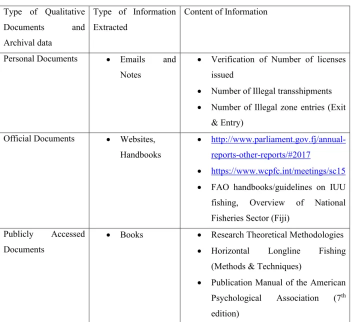
Table 3.2 Type of Qualitative documents and Archival data and information extracted Type of Qualitative Documents and Archival data Type of Information Extracted Content of Information
Personal Documents • Emails and Notes
• Verification of Number of licenses issued
• Number of Illegal transshipments • Number of Illegal zone entries (Exit
& Entry) Official Documents • Websites,
Handbooks
• http://www.parliament.gov.fj/annual-reports-other-reports/#2017
• https://www.wcpfc.int/meetings/sc15 • FAO handbooks/guidelines on IUU fishing, Overview of National Fisheries Sector (Fiji)
Publicly Accessed Documents
• Books • Research Theoretical Methodologies • Horizontal Longline Fishing
(Methods & Techniques)
• Publication Manual of the American Psychological Association (7th edition)
3.3 Quantitative Research
All statistical data and reports gathered were tabulated, others were recorded on excel spreadsheets and on a research notebook, depending on the mode that it is best suited to. Wolcott (1994) states that “Everything has the potential to be data, but nothing becomes data without the intervention of a researcher, who takes note- and often makes note of some things to the exclusion of others. In primary quantitative research, data is collected from the source directly rather than
31
depending on data collected from previously done research, secondary qualitative research on the other hand is the use of already existing data (Bhat, 2020).
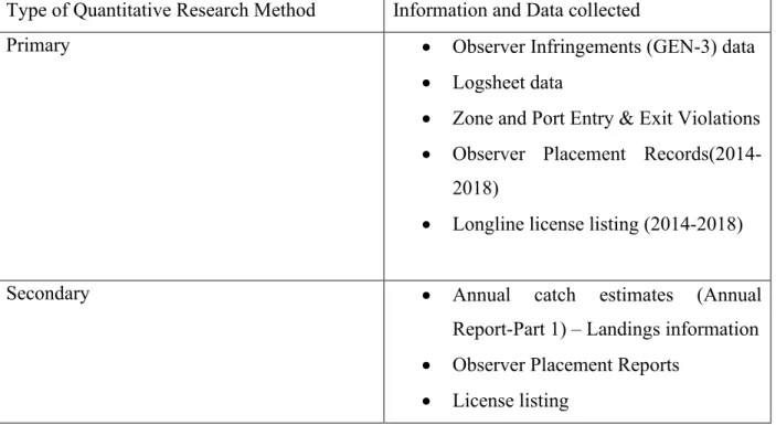
Table 3.3 Data and information collected through Primary and Secondary Qualitative research Source: Offshore Service Centre
Type of Quantitative Research Method Information and Data collected
Primary • Observer Infringements (GEN-3) data
• Logsheet data
• Zone and Port Entry & Exit Violations • Observer Placement
Records(2014-2018)
• Longline license listing (2014-2018)
Secondary • Annual catch estimates (Annual
Report-Part 1) – Landings information • Observer Placement Reports
• License listing
3.3.1 Collection of data and information through Primary Research
Observer Infringements and violations were recorded by Fisheries Observers while on deployment out at sea. These are non compliance observed and recorded by the fisheries observers as they are known to be independent and impartial, and not required to enforce any national laws whilst out at sea. Data for the past five years from 2014-2018 was collected through this avenue and was then tabulated as to reflect only the identified infringements that could possibly be verified with VMS data. Verification of these identified infringements can be cross checked with the application of historical VMS data given all the specific details, such as the date, time and vessel
32
position when the infringement occurred is available. The information was collected and provided for by the Monitoring Unit of the Offshore support centre.
Catch logsheet data for the past five years from 2014-2018, was also acquired and the total catch from the three main tuna species (Albacore, Bigeye and Yellowfin) and the other by-catch species was calculated. Catch Logsheet records the total catch by species, by weight and also records the catch, by species, by weight that has been discarded.
The number of unauthourised fisheries related activities was also collected. These activities are namely transshipment and bunkering. This information is accessed from the Licensing and Permitting Unit along with the license listing for the past five years that is from 2014-2018. Other supporting information that is also cross checked are the permits that are issued for carrying out these fisheries activities out at sea, such as transshipment, bunkering or provisioning. These activities should only be carried out once the approval is made. It becomes unauthorized if it occurs out at sea without first, soughting proper approval. The time the application is lodged for approval will also be taken into consideration, should the activity have taken place prior to when the approval was given. The time and date it occurred can be verified with VMS data and information, pending further investigation.
Other Statistical data collected was from Port and Zone Entry and Exit Notifications (Violation to Regulation 39(b) and Regulation 42). For fishing companies or agents that fail to apply for a zone entry notification or inform the Mnistry of Fisheries, upon entering Fiji’s EEZ or leaving Fiji’s EEZ they are usually fined with a Fixed Penalty Notice(FPN) of $2,000 or they have the option where they can go to court to present their case. The verification of this information can be cross-checked with VMS data as to the date, time and position of entering or exiting Fiji’s EEZ
33
or the location of the vessel 24 hours before calling into port. This information was collated from the Enforcement and Surveillance Unit.
3.3.2 Collection of data and information through Secondary Research
Data and information collected through this avenue include Landings summary. This was retrived from the Part 1 Report (SC15-2019), Annual catch Estimates (2014-2018). Logsheet and Landings summary is usually reconciled with VMS data and information so as to ascertain and verify the information on vessel location (position) and fishing activity. Landings summary is the number of catch that is actually landed and what was discarded. This information is collated from the Data Unit housed at the Offshore Service Centre. Other information collected include Transhipment and Observer Coverage, this was accessed from the Offshore Fisheries Annual Reports for the past five years from 2014 – 2018.
3.4 Data Processing and Analysis
In verifying the occurance of these fisheries activities out at sea, the application of VMS data will also verify the date, time, position and speed of the fishing vessel to see the probability of these illegal and unauthorized activities taking place. The Surveillance Officer in monitoring the Fiji fishing vessels in zone and outside Fiji waters identifies suspicious activity occurring out at sea and cross checks with authorization or permits issued. However, suspicious behavior of fishing vessels warrants further investigation. Observer reports indicate the account of activities recorded out at sea and also confirms the allegation.
Port and Zone Entry Notification data was collected from the number of Fixed Penalty Notice (FPN) issued as a result of non compliance to the Regulation 39 (2)(b) and Regulation 39 (2)(e) of the OFMR (2014), of failing to notify the port state forty-eight and seventy-two hours
34
prior to entering Fiji’s EEZ and a fisheries port. On instances where this has occurred, the application of VMS data is used to determine the date, time and vessel position, the vessel is supposedly have entered Fiji’s EEZ. This is cross checked with the vessel operator’s or agent’s application on Port and Zone Entry Notification. The vessel can always face a fine should the checks prove that the vessel operator or agent’s application is late and does not correspond to the estimated date, time and position of when the fishing vessel is suppose to have entered or left Fij’s EEZ.
Catch information was also tabulated and graphically represented as to show the catch trends over the years, and the difference arising from the total catch, that is, from landings data and that of logsheet. The difference between the two is usually the under-reported or mis-reported portion of the catch and discards or the non reporting of catch at all. Landings data is the summary of what is exactly landed in the fisheries ports, by species, by weight while the logsheet data is the record of what is caught out at sea, captures number of catch retained and those that are discarded as well.
35 CHAPTER 4
RESULTS AND DISCUSSION
4.1 Landings and Log sheet Data
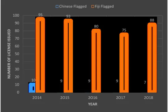
Figure 4.1 Annual Catch Estimates for the Fiji National Fleet, 2014-2018 Source: Data Unit, Offshore Service Centre
The graph above (Figure 4.1) shows the total catch estimates of Tuna (Albacore, Big eye and Yellow fin) and Tuna like species caught in Fiji EEZ, High Seas and in neighbouring EEZs. Number of catch graphically represented in this graph is taken from the landings summary which is submitted by the fishing companies to the Offshore Service Centre for the processing of their landing permit. It contains the number of catch by species by weight that is landed in any of Fiji’s designated ports. It should be noted that there was an increase in catch from 2015 as compared to the previous years. This was mainly because catch reports was based on landings, which is the actual number of catch landed in Fiji’s designated ports as compared to the past years where catch reports was extracted from logsheet (Ministry of Fisheries, Part 1 Annual Scientific Report to WCPFC, 2016). Two years after, total catch estimates increased by 3,434mt, with total Albacore (ALB) catches of 9,837mt, the highest recorded since 2013 (Ministry of Fisheries, Part 1 Annual