Technical Note of the National Research Institute for Earth Science and Disaster Prevention, No. 380 ; July, 2013
-161 - * National Research Institute for Earth Science and Disaster Prevention
** Department of Geosystem Sciences, College of Humanities and Sciences, Nihon University 1. Introduction
Since becoming an independent agency in 2001, the National Research Institute for Earth Science and Disaster Prevention (NIED) has followed five-year medium-term research plans in addressing the safety and security of Japanʼs citizens.
The NIED is pursuing three key research initiatives with the goal of developing a reliable way to predict volcanic eruptions and contribute to volcanic disaster mitigation: strengthen the nationʼs volcanic observation network for monitoring volcanic activity, upgrade remote sensing capabilities to track volcanic activity, and develop simulation techniques to predict volcanic activity and volcanic hazards.
This report provides an overview of these initiatives and the progress achieved so far over the past seven years (i.e., during the 2nd five-year research plan (2005-2010) and the first two years of the 3rd five-year research plan (2011-2016)). For more detailed descriptions of these developments, please refer to the individual websites of the NIED researchers that can be accessed here: http:// vweb2.geo.bosai.go.jp/intra/member/index.html).
2. Strengthen the Volcanic Observation Network for Monitoring Volcanic Activity
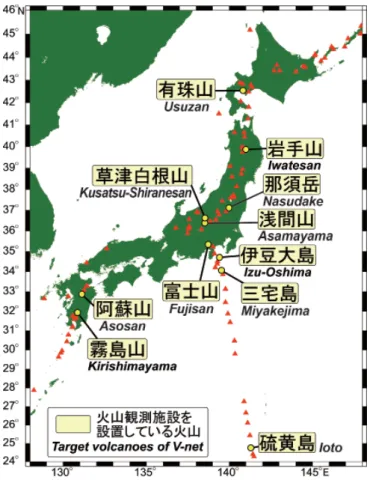
Based on the volcanic eruption prediction plan, NIED extended the Volcano Observation Network to cover Ioto in the early 1980s; Izu-Oshima in the late 1980s; and Miyakejima, Fujisan, and Nasudake in the 1990s. Deployment plans for the volcano observation research stations were carefully considered by the Volcano Subcommittee of the Geodesy Division of the Science and Technology Council in 2008, and basic observational facilities were built up at volcanoes with high research potential by the NIED: volcanoes showing a high degree of activity, volcanoes that are currently appear dormant but show signs of explosive activity, and so on. In accordance with this policy, NIED constructed volcano observation stations at eight sites on a total of five volcanoes between 2009 and 2010—Asosan, Uszan, Iwatesan, Asamayama,
Volcano Disaster Mitigation Research Initiatives at National Research
Institute for Earth Science and Disaster Prevention
Toshikazu TANADA* and Motoo UKAWA**
and Kirishimayama—and one station at Mt. Kusatsu-Shirane in 2011. In 2013, NIED will continue to observe and monitor a total of 11 volcanoes including the six just mentioned (Fig. 1).
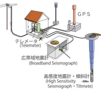
Fig. 2 illustrates a typical volcano observation station. As one can see, stations are equipped with short-period seismographs, tiltmeters, GPS, broadband seismographs, barometers, and precipitation meters. The combination of short-period seismograph and tiltmeter is functionally equivalent to a high sensitivity seismograph with a tiltmeter, and successfully picked up precursory signals of the recent eruptions on Izu-Oshima and Miyakejima. All these seismic and volcano-related data are continuously transmitted back to NIED 24 hours a day by using an IP
Fig. 1 Volcano Observation Stations deployed by NIED.
Technical Note of the National Research Institute for Earth Science and Disaster Prevention, No. 380 ; July, 2013
-162 - virtual private network (IP-VPN) over NTT circuits.
The integrated data are processed continuously 24 hours a day for automatic hypocenter detection, automatic anomaly detection of crustal deformation data, and automatic modeling on systems developed by NIED. This processing system performs very well as evidenced by its success in detecting crustal deformation anomalies and modeling the Kirishimayama and the Izu-Tobu volcano group, and the observational data are periodically reported to the Japan Meteorological Agencyʼs Volcanic Eruption Prediction Liaison Council for use in evaluating volcanic activity. All this observational data—continuous waveform images, average short-period seismograph amplitude changes at 1-minute intervals, and tiltmeter change charts—can be viewed on line at the Visualization System for Volcanic Activity (VIVA) website (http://vivaweb2. bosai.go.jp/viva/v_index.html). Moreover, beginning in January 2013, earthquake and tiltmeter data will be assessable on the Volcanic Observation Network (V-net) site (http://www.vnet.bosai.go.jp/), including a statement of purpose and download instructions. At present in August 2012, both of these sites are getting between 2,000-4,000 page visits a day.
The volcano observation data are sent directly to the Japan Meteorological Agency, the agency responsible for monitoring volcanic activity, over an IP-VPN link in accordance with an agreement signed on February 1, 2011 to exchange volcano observation data. The data are also provided to academic volcano research institutes through the University of Tokyo Earthquake Research Institute. In addition, the NIED periodically conducts geochemical analysis of ground water and thermal water around volcanoes, and measures hydrogen and oxygen isotope ratios to check for the presence of magmatic water.
3. Remote Sensing Capabilities to Track Volcanic Activity
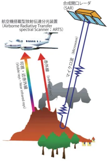
The NIED has developed remote sensing technologies and new analytical methods for monitoring and assessing volcanic activity. Starting with the development of a remote high-spatial-resolution thermal imaging system to assess volcanic thermal activity in the 1980s, the 1st generation VAM-90A, a scanning spectrometer with nine spectral bands, was completed in 1990, and operated until 2007. This was followed by a 2nd generation Airborne Radiative Transfer Spectral Scanner (ARTS) for volcano observation that was put into service in 2008. The spatial resolution of ARTS is capable of identifying features measuring 0.5-to-1 square meter from altitudes ranging from 700 to 6,500 meters. The ARTS imaging spectrometer detects light energy (radiance) from visible to infrared covering wavelengths for up to 421 bands, which enables ARTS the measure surface temperatures from -20 to 1,200 °C as well as volcanic gas (SO2 gas) concentrations (Fig. 3). Through 2010, ARTS was used to successfully measure approximately 50 scenes from Asamayama and six other active volcanoes. For example, just after Asamayama eruption on February 2, 2009, we were able to evaluate the thermal activity, that is, it had not expanded inside the crater by comparing measured results before the eruption (November 2008) and after the eruption (February 21, 2009). ARTS was also used to successfully estimate the surface concentration density of volcanic gases (sulfur dioxide gas) for three volcanoes: Sakurajima, Asosan, and Miyakejima.
Another valuable tool is synthetic aperture radar (SAR) for obtaining high-density crustal deformation data, which are invaluable for evaluating complex behavior of magma. This research employs a new time-series-based method of analysis called InSAR that combines SAR images obtained using multiple satellite passes to form interferograms. By reducing noise caused by phase propagation through the atmosphere and troposphere, very high resolution maps of crustal deformation were obtained around the craters of Kirishimayama and Miyakejima volcanoes (Fig. 3). Radar is also used to monitor and observe volcanic plumes. Working together with NIEDʼs Storm, Flood and Landslide Research Unit, we employed X-band weather radar operated by the Ministry of Land, Infrastructure, Transport and Tourism (MLIT) to analyze the explosive eruption of Sakurajima in 2008 and the eruption of Kirishimayama (Shinmoedake) in 2011. We found that X-band weather radar was fully capable of observing explosive eruptions.
Fig. 2 Schematic of Volcano Observation Station.
Volcano Prevention Research Initiatives at National Research Institute for Earth Science and Disaster Prevention — T. TANADA and M. UKAWA
-163 -
4. Simulations to Predict Volcanic Activity and Hazards
The NIED has made excellent progress in developing and exploiting simulation methods for assessing volcanic activity and predicting volcanic hazards. For example, we performed a simulation using the distinct element method to model crack growth and magma intrusion in 3D stress fields caused by magma movement, and were thus able to evaluate elastic deformation, plastic deformation (breakage), and stress field changes around the magma. We also developed a method for simulating static stress field changes near volcanoes caused by plate boundary earthquakes in a subduction zone, and an approach that proved very fruitful for evaluating the effects of the magma chamber under Fujisan. Conducting a numerical analysis of the process of gas-liquid two-phase magma moving up the volcanic conduit, we were able to analyze the movement of magma from the magma chamber up the conduit to erupt on the surface by employing a hydrodynamic numerical model. In other words, by developing this time-development model that replicates the transition process from a non-explosive eruption to an explosive eruption, we can successfully simulate the process of pressure change within the volcanic conduit
(Fig. 4). Simulation is a powerful tool for predicting volcanic hazards. For example, by evaluating mesh-size dependence of topology data and large-scale lava flows, we successfully simulated a scenario lava flow from Sakurajima Showa crater.
Fig. 3 Volcanic observation by remote sensing.
5. Research Results and Giving Back to Society
Kirishimayama (Shinmoedake) erupted on January 26, 2011, and is still active as of October 2012. The Volcano Observation Network (V-net) stations mentioned earlier in Section 1 that were deployed on Kirishimayama in 2010 based on the policy outlined in 2008 by the Volcano Subcommittee, Subdivision on Geodesy and Geophysics, Council for Science and Technology proved very useful for capturing the entire process from magma accumulation to eruption. At the same time, analytical results regarding occurrence of earthquakes and location and size of magma chambers that expand as magma accumulates and contract with eruptions are provided to the Coordinating Committee for the Prediction of Volcanic Eruptions and are highly useful for evaluating volcanic activity. The East Shizuoka earthquake (MJMA 6.4) struck at the foot of Fujisan on
March 15, 2011. When the earthquake occurred, we were able to infer a fault model from the coseismic crustal deformation and hypocenter distribution observed by NIEDʼs tiltmeter and GPS. Using the simulation program described earlier, we were also able to assess the impact of the Fujisan magma chamber.
6. Pursuing Domestic and International Collaborative Research
When drilling boreholes for tiltmeters and other observation equipment at Volcano Observation Network sites, the entire length of the geologic core samples are collected. These samples are extremely useful for investigating the past history of volcanic activity at sites that cannot be discerned from surface outcrop topography,
Fig. 4 Simulation of the upward flow of magma in conduit.
Technical Note of the National Research Institute for Earth Science and Disaster Prevention, No. 380 ; July, 2013
-164 - and are therefore shared with local universities and research labs for further assessment of the geology and petrology of the volcano.
In terms of international collaboration, NIED shares its observational data with the World Organization of Volcano Observatories (WOVO) international database WOVOdat with the goal of sharing knowledge that contributes to the prediction of volcanic eruptions. NIED also collaborates with sister organizations in Indonesia, the Philippines, and Ecuador in building earthquake and volcano observation networks, by archiving data and research about earthquakes and volcanic eruptions, and pursues collaborative studies with the goal of mitigating earthquake and volcanic hazards.
7. Outreach Activities
The NIED is committed to disseminating information that raises peoplesʼ awareness and helps mitigate volcanic hazards. Working together with the NIED Disaster Information Laboratory (DIL) and the Commission on Mitigation of Volcanic Disasters, the Volcanological Society of Japan, a compilation of volcanic hazard maps for Japan was published in 2006. Later, a DVD version of volcanic hazard map collection was created and widely distributed to academic groups and workshops throughout Japan and the world.
The NIED holds an annual Science and Technology Week Open Institute event every April. In order to promote greater understanding and interest in volcanoes among the general public, the event features a video presented by the Volcano Research Group showing an active volcanic eruption, an indoor display of cinder, lava, and other forms of volcanic rock, and an outdoor experiment enabling visitors to experience first-hand what an eruption is like. The NIED also hosts a number of disaster prevention educational events for elementary and middle school age children including Tsukuba Chibikko Hakase (for younger children) and a Summer Science Camp.
In addition, since 2003 the NIED has cosponsored an biennial International Workshop with the Yamanashi Institute of Environmental Sciences that focuses on polices and measures for mitigating volcanic hazards. As one can
tell from the themes covered at the last few workshops— “Learn from attempted eruption events” (2007), “Crisis management in the event of large-scale eruptions (level 4-5)” (2009), and “Real-time assessment and government response to volcanic disasters” (2011)—the International Workshop is not just for professional volcanologists from Japan and elsewhere. Recently a local government official was invited to speak at the Workshop, and discussion usually centers on the current state and challenges of volcanic hazard mitigation.
NIED has also put up a website called Learn more about volcano hazards! (http://www.bosai.go.jp/ realtime/volcano/detail01.html) for relative beginners that introduces a wide range of references and resources organized into three subsections: Books, Instructional Materials, and Professional websites. Here I would call attention to two pamphlets available in the Instructional Materials section that are offered in collaboration with the International Association of Volcanology and Chemistry of the Earthʼs Interior (IAVCEI) and other organizations: “Health consequences of volcanic ash” and “Prepare for falling ash.” These two brochures were widely distributed through local government and mass media channels after Kirishimayama (Shinmoedake) erupted in 2011, and are filled with useful and practical advice.
8. Conclusions
This paper has provided a broad overview of the volcano preparedness and management initiatives and research achievements at NIED over these past ten years. Over the decade, NIED deployed a Volcanic Observation Network that circulates data based on remote sensing capability, developed innovative new methods of analysis, and introduced simulation techniques used to validate eruption theories. At the same time, the NIED developed observational techniques that markedly improve our ability to predict and explain volcanic phenomena. NIED remains committed to mitigate volcanic hazards, and will continue to gather observational data, develop new technologies for tracking and studying volcanic activity, refine volcanic eruption theory, and develop innovative simulation models.