The Association of Japanese Geographers http://www.ajg.or.jp
A Cross-Cultural Comparison of
Human Wayfinding Behavior Using Maps and Written Directions
SUZUKI Koshiro
Faculty of Humanities, University of Toyama; 3190 Gofuku, Toyama 930–8555, Japan.
E-mail: [email protected]
Received November 27, 2009; Accepted January 25, 2013
Abstract The aim of this study is to prove the existence of cultural diversity in human spatial cognition between Japanese and Americans by conducting a cross-cultural wayfinding experiment. Twenty Japanese and 19 US univer- sity students were instructed to walk through a route on campus twice using either a map or a written direction and were asked to evaluate the effectiveness of the materials used on a 7 grade scale after each trial. They were also asked to compare the usability of the two materials after completing the trials. Their errors and time-performance were also measured. The results derived from an application of a quantitative analysis revealed the existence of cultural differ- ences in the relative evaluation task, although the actual performances did not show a significant difference. Further- more, their absolute evaluation scores of the first trials obtained from the language-first group indicated that Ameri- cans gave written directions considerably higher ratings than Japanese, whereas the second trials of the map-first group disclosed that Japanese rate the same material considerably lower than Americans. The results demonstrated that participants felt discomfort with the less familiar medium even when the wayfinding task was easy enough to follow. Such uneasiness may stem from the cultural schema of spatial descriptions to which they have been famil- iar. When the description style of provided material was not archetypal from the viewpoint of their shared cultural schema of geographic description, people tended to feel larger discomfort because of the mismatch.
Key words wayfinding, cross-cultural comparison, spatial cognition, geographic information transmission
Introduction
Human beings can obtain spatial knowledge both from direct and indirect sources of information, such as maps and linguistic descriptions. It is essential to share the understanding toward the semiotic system of the infor- mation transmission device, to communicate his (her) spatial knowledge to other persons or to obtain geo- graphic information from cartographic materials. This type of mapping abilities, such as the ability to manipulate symbols, cannot be isolated from the users’ socio-cultural background (Downs and Liben 1992, 1993; Golledge and Stimson 1997; Suzuki 2000).
On many occasions, wayfinding is performed through an information exchange process such as learning how to use various geographic information sources or ask- ing someone to provide written directions of the route.
Therefore, even though human beings naturally possesses mapping abilities and prior knowledge of their behavioral space to some extent, it is highly conceivable that the de- scription schema in spatial cognition should be also dem- onstrate constructed cultural and social differences.
Until recently, studies on the cultural or social varia- tions in mapping styles have been extremely limited. Ex-
ceptions include anthropological case studies that mainly focused on the cultural variety of human spatial infor- mation transmission process (Gladwin 1970; Lewis and George 1991; Nonaka 2004) or developmental psycho- logical studies examining the development of spatial cog- nition by comparing children’s developmental changes in map-reading or map-drawing abilities with age in differ- ent countries (Spencer and Darvizeh 1983; Yamano 1985;
Blades et al. 1998). However, such findings are difficult to generalize since they were obtained from specific envir- onments or age groups.
Recently however, some researchers came to focus on human wayfinding behavior and geographic information transmission from a cross-cultural viewpoint. Daimon et al. (2000) conducted a sketch map and verbal protocol analysis on drivers’ navigation behavior for Swedish and Japanese residents, and found that the Swedish tended to rely more on path information and information of wheth- er to turn at the critical crossroads, whereas Japanese rely more on the information of landmarks and the location of crossings of where to turn.
Likewise, Mainwaring et al. (2003) compared the use of a relative referential frame in linguistic direction-giving between Japanese and Americans and pointed out that
Americans tended to describe space with more reliance on the sentence from an egocentric point of view.
Davis and Pederson (2001) focused on the effect of familiarity with the typical environment from a cross- cultural viewpoint. By comparing the scores of pointing accuracy, verbal navigation, and sketch map tasks ob- tained from US and UK participants, they pointed out that regularity in grid pattern of their residence affect UK participants in terms of a heavier reliance on landmarks in navigation tasks as well as leading to higher scores in pointing accuracy.
In Japan, there are a handful of similar case stud- ies. Takai (2004) compared the developmental process of spatial knowledge and usage of environmental cues for navigational aids of Japanese and Brazilians of Japanese ancestry, and found Brazilian residents were more likely to rely on route-based cognitive mapping.
These types of studies intend to shed light on the cross- cultural aspect of human spatial cognition in general.
However, most of them are not focused on complemen- tary use of linguistic and imagery information1 because they dealt with them as a means to externalize their men- tal representation. Furthermore, such studies failed to ad- dress the adequate scientific criteria of selecting the target countries and regions. For instance, in the Blades et al.
(1998) study, the groups of children were collected from five different countries for conducting a cross-cultural experiment. However, they did not give any precise ex- planation of how they decided the countries and regions.
Hence, regional and cultural factors are sometimes con- founded in many studies.
For a successful cross-cultural comparison of human wayfinding, we should distinguish cultural and environ- mental factors. Therefore, the author has done a series of content analysis of Japanese and American tourist guide- books describing Japanese and American cities (Suzuki 2003; Suzuki and Wakabayashi 2005). By selecting two cities of different regional characteristics as a pair from both Japan and the United States, feasible factors affecting the spatial description were distinguished.
The results in the author’s previous studies demon-
strated that Japanese guidebooks are primarily based on visual means (namely maps), whereas American ones depend heavily on written direction (linguistic direction).
This can be due to differences in the address systems be- tween the two countries. The address system is typically based on blocks in Japan whereas it is based on streets in America. It is not efficient for the Japanese address system to provide a linear route description from one specific or- igin to a specific destination because features on the maps are subject to be generalized as icons and further descrip- tion of each site is omitted. On the other hand American street address systems are not efficient enough to grasp a configurational image of a city since the address sys- tem is a collection of origin-to-destination sets. Instead, American discourse in spatial description cannot be used if the city does not have street names. Therefore, the most striking cultural difference between the two countries can be reflected on the proportional use of maps and written directions.
These findings suggest that even educated people from developed countries show a bias towards their own cul- turally shared schema in their spatial information trans- mission processes. However, such diversity in spatial description does not automatically prove that diversity influences people’s spatial cognition and wayfinding be- havior as a cultural schema. The purpose of this study is to investigate the influence of socio-cultural differences in spatial description on human wayfinding strategies using maps and written directions.
Experimental Design
The experiments were operated on a route at the Uni- versity of California at Santa Barbara (UCSB) main cam- pus between late March and early July in 2005. The par- ticipants were 20 Japanese and 19 American students.
These participants were either native Japanese or Ameri- can speakers except for two Americans. The two excep- tions were a male who has a Japanese close relative and a female who was born in New Zealand and had lived there for several years before she came to the United
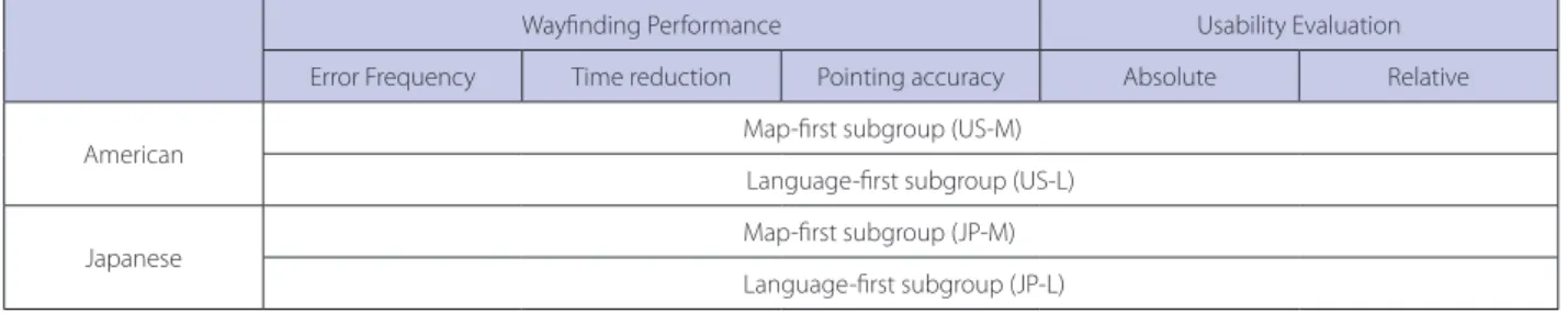
Table 1. Experimental design
Wayfinding Performance Usability Evaluation
Error Frequency Time reduction Pointing accuracy Absolute Relative
American Map-first subgroup (US-M)
Language-first subgroup (US-L)
Japanese Map-first subgroup (JP-M)
Language-first subgroup (JP-L)
States. Some volunteers from both groups were addition- ally called for pilot studies.
The main experiment consisted of a questionnaire, and two wayfinding trials as a pair. On both trials, all partici- pants from both cultural groups were subdivided to either (a) map-first, or (b) language-first subgroups (Table 1).
The participants in the map-first subgroup were asked to follow a route on campus using a map for directions whereas the other subgroup was asked to do the same by
referring to navigational sentences printed on a sheet of paper. Both of these materials were printed on a paper in 20.32 cm (8 inches) by 29.21 cm (11.5 inches).
The map used in this experiment was made by use of a digitized full color image of an aerial photograph and the component parts of the campus were classified into bikepath, building, road, parkinglots, grass, sand, sidewalks, vegetation, and water (Figure 1). As for the directions in the navigation script, they were produced by Figure 1. Map material used in the experiment: A black thick line on the map indicates the experimental route.
the following procedure2. First, the experimenter made a preliminary draft of written directions while walking the experimental route. Second, two American graduate stu- dents corrected grammatical mistakes in the draft. Third, one pilot participant who was visually impaired walked through the route by following the written direction and tested its reliance, and the script was once more edited to include his suggestions. A Japanese version of the direc- tion involved the direct translation of the English one (Figure 2). To ensure that the material qualities of each device did not produce any influence on the scores of the two trial groups of each country, t-tests were carried out on the average of all map-trial and language-trial scores.
Results did not reveal any significance in each of Japanese and US trial groups (t=0.6372, p= 0.5282 for their error frequencies; t=1.4545, p= 0.1543 for the absolute scores of their 1st trial).
The experimental route was approximately 1.31 km (0.81 miles) long and contained 11 turns. The origin of the route was set to be diagonally backward-left from the direction heading to the destination building. This was to make pointing task, as will hereinafter be described in de- tail, difficult enough for the participants who are familiar with the campus. After three to seven days from their first trials, participants were asked to follow the same route by use of the other directional device. In consequence, all participants were asked to follow the same route twice, referring to either map or language for each trial. Because the material provided is different on each trial (either
map or written directions), all participants should expe- rienced the guidance of maps and language of the exact same route when they completed the wayfinding tasks.
The only difference was the order of the materials used.
After answering the questionnaire, participants were asked to take part in the first trial. Most previous way- finding studies focused on the wayfinding performance as the object of analysis (Golledge et al. 2000). In this study, three kinds of measures were applied to evaluate the par- ticipants’ performances. Those were error frequency, time reduction, and pointing accuracy (Table 1).
For calculation of error frequency measure, partici- pants’ performances were videotaped. The number of er- rors was counted in the completing process of wayfinding tasks for each participant. When a participant went off the experimental route and could not correct the error independently within the next 10 seconds, the experi- menter announced the fact that the participant had just missed the route (then, the error counted as 1). In case the participant declared that he/she could not modify the error or gave up re-orientating himself/herself on the spot where the error had occurred, the experimenter broke off the experiment and time keeping, and lead the par- ticipant to where the error occurred, and pointed out the spot on the material again for re-starting the experiment.
The time duration required for completing the trials was recorded. The time difference between the first and second trials was employed as a time reduction measure.
At the end of the first trial, participants were also request- Figure 2. An example of navigational sentences used in the experiment.
ed to point out the direction to where they had started, while facing the destination building (pointing accuracy).
For answering the pointing task, a circle with a central point was printed on the questionnaire with an explana- tory text instructing that the circle should be aligned in head-up manner. In other words, by orienting themselves in the middle of the circle, the upside of the circle repre- sents the forward direction from the participants’ point of view. Then participants were asked to draw an outward- directed arrow from the central point to describe their believed direction to the starting point. In case the direc- tion of the arrow went beyond 45 degrees either to the right or left from the correct direction, it was estimated as an error.
It is highly conceivable that participants’ wayfinding performances reflected differences in their prior knowl- edge of the environment more than their socio-cultural background. In fact, some previous studies on the way- finding showed that certain systematic distortion was formed in accordance with prior knowledge and experi- ence in an environment (Herman et al. 1979; Kirasic et al. 1984). Therefore, in this study, the author applied two types of evaluation measures, absolute and relative evalua- tions, along with the three performance measures.
To remove the disturbance-effect derived from the dif- ference in difficulty of the experimental routes, all par- ticipants in the present experiment were asked to walk through the same route twice before evaluating the two materials used respectively for each trial. Since all partici- pants could use their prior knowledge about the experi- ment route on their second trials, the second wayfinding task can be considered as much easier than the first.
This suggests that we should take into account partici- pants’ familiarity with the experimental route as well.
Therefore, both Japanese and American participants were subdivided into two groups, map-first and language-first, to investigate whether participants’ familiarity with the route through performing their first trials or their cul- tural background affected the results.
All participants were asked to evaluate the usability of the material provided on a 7 grade scale for each trial (absolute evaluation): From 1, indicative of completely useless, to 7, indicating that it was completely useful. In addition, they were asked to report their familiarity with
the experimental route on a 7 grade scale after their first trials: From 1, that is indicative of completely unknown, to 7, indicating that the participants were completely familiar with it. All the participants were also required to compare the relative effectiveness of the two materials they had used, after their second trials (relative evalua- tion).
As stated above, the relative evaluation indicates the result of each participant’s mental relative effectiveness of the materials (maps versus written directions, and vice versa) used on the two trials. The evaluation was done by asking participants to mark the perceived usefulness on the provided scale (Figure 3). Any participant who had used the map on the first trial and throught that written directions were better than the map for navigat- ing, for instance, should mark anywhere in the right half of the scale. The distance from the center indicates the participant’s heavier mental dependence on either device in comparison to the other for wayfinding performance.
Each side of the scale has three calibrations including in- dicative of even, material in 1st or 2nd trial, and the mid- dle of these two. Therefore, the marks were quantified in 5 grades: 0 (even), 2 (on the middle), 4 (material in either trial), and anywhere in between 0 and 2/ 2 and 4.
All results were classified by trial-subgroup and par- ticipant type, and then the t-tests were used to determine whether there was a statistically significant difference be- tween the Japanese and American group means of evalu- ation of scores as well as their performance scores ob- tained from their map and language trials.
Hypotheses
Our previous guidebook studies (Suzuki 2003; Suzuki and Wakabayashi 2005) showed that Japanese guidebooks heavily depended on visual expressive medium such as maps and photography, whereas American ones mainly relied on linguistic means such as written directions.
Given that there is socio-cultural difference in spatial information transmission, it should be easier for Japa- nese to navigate themselves with the use of visual-based spatial information rather than linguistic ones, whereas Americans tend to rely on linguistic rather than visual ones. Hence, in case the experiment is operated in an
Figure 3. Rating scale of relative evaluation.
environment of which the participants have limited or no prior knowledge, the types of spatial information material should have significant effects on the participants’ evalua- tions of the effectiveness of the two materials as well as on their task performances.
As all the participants’ familiarity with the UCSB cam- pus grows, the individual difference in forms of their cognitive maps on the campus could become deeper.
Therefore, it is highly pertinent that there is a significant correlation between the participants’ familiarity with the experimental route and their task achievements. As ex- plained earlier, such kind of experiences cannot differ be- tween Japanese and American students. Hence, their fa- miliarity with the campus should have been influenced by their individual background such as the departments to which they belonged and the classes they have attended, and the evidence of the socio-cultural differences could not be observed in task achievement scores. In fact, how- ever, the result of the t-test proved there was no signifi- cant difference on the average familiarity scores between Japanese and American participants (t=0.127, p= 0.900).
In general, difference in participants’ prior knowledge, which affects their task performance, makes it difficult to extract solitary socio-cultural aspects on spatial cogni- tion. However, familiarity with the environment had less
impact on the evaluation of usability of the maps and written directions used in the experiment, since the par- ticipants simply evaluated the effectiveness of the materi- als.
In sum, two hypotheses are examined in this article.
These hypotheses are: (1) even though individual differ- ences such as participants’ prior knowledge of the envir- onment have greater effect on their task performances, socio-cultural differences can still be observed in their evaluations of the materials used in the present experi- ment. (2) Japanese participants are more likely to depend on visual expressive medium such as maps and photog- raphy, whereas American participants mainly rely on lin- guistic media such as written directions. Therefore Japa- nese participants should find significantly higher usability in maps rather than linguistic media, whereas Americans feel vice versa while completing their wayfinding tasks.
Results and Discussion
Results
All of the average scores from absolute and relative evaluation as well as error frequencies on the first and second trials were assessed by t-test (Tables 2 and 3).
The t-tests were applied with respect to difference in
Table 2. Results derived from application of the t-tests on participants’ evaluation Average
t-value P
JP US
Language-first
Absolute evaluation (1st trial) 6.00 6.60 5.06 *
Absolute evaluation (2nd trial) 6.00 6.40 1.16 n.s.
Relative evaluation 2.80 1.20 8.47 **
Map-first
Absolute evaluation (1st trial) 5.90 5.89 0.00 n.s.
Absolute evaluation (2nd trial) 4.50 6.56 12.73 **
Relative evaluation 1.20 −1.11 6.28 *
Statistically significant at **.01 or *.05 level. n.s.: Not significant at .05 level.
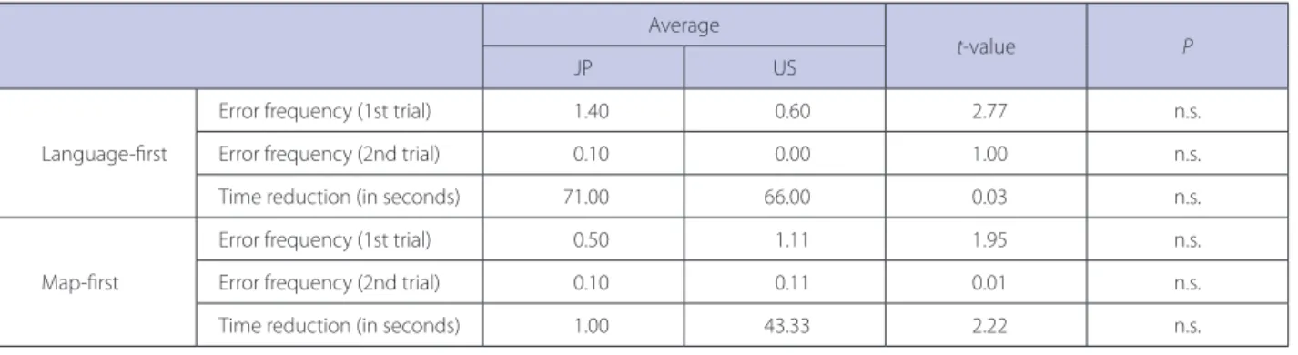
Table 3. Results derived from application of the t-tests on participants’ error frequency and time reduction Average
t-value P
JP US
Language-first
Error frequency (1st trial) 1.40 0.60 2.77 n.s.
Error frequency (2nd trial) 0.10 0.00 1.00 n.s.
Time reduction (in seconds) 71.00 66.00 0.03 n.s.
Map-first
Error frequency (1st trial) 0.50 1.11 1.95 n.s.
Error frequency (2nd trial) 0.10 0.11 0.01 n.s.
Time reduction (in seconds) 1.00 43.33 2.22 n.s.
n.s.: Not significant at .05 level.
the average of the absolute and relative evaluation be- tween the Japanese and Americans (Table 2). Regarding the language-first group, results derived from applica- tions of the t-test reveal a significant effect of cultural differences on relative evaluation values at 0.01 level. The average value of relative evaluation obtained from the Japanese participants is significantly higher than that of the Americans.
Using the t-test, a comprehensive analysis of the differ- ence between the average of the two absolute evaluation scores between the pair of two subgroups (map-first or language-first; Japanese or American) was conducted.
The result based on the comparative analysis revealed that there are significant differences between the two countries (Table 2). Comparing with the language-trial scores of absolute evaluations, that of the Japanese map- first group, 4.50, was significantly lower than that of the Americans map-first group, 6.56. The t-test result reveals the significance at 0.01 level. On the other hand, absolute evaluation scores of the first trial groups between Japa- nese and Americans indicate the opposite tendency in the language-first subgroup, 6.00 for Japanese versus 6.60 for Americans. The t-test result indicates the significance at 0.05 level.
Based on these observations, the author can infer that the Japanese participants of the map-first subgroup felt stronger discomfort than the Americans on their second trial, even though their second task should have been easier thanks to prior knowledge of the route obtained on their first trial. On the contrary, American participants of language-first subgroup tended to feel more at ease than Japanese when using written directions on their first trial. The fact clearly indicates that Americans are better at using linguistic information because the language-first group of Americans averaged significantly higher scores than Japanese and the pair of the other subgroup.
Regarding the error frequency and time reduction, all the results of the t-test disclose no statistical difference between the Japanese and Americans (Table 3). In terms of reduction of approximate time required for the second task and frequency of errors, the Japanese map-first group reduced the amount of required time by just 1 second on average, whereas the Japanese language-first group took 71 seconds less on average on their second trials. Like- wise, the error frequency rate of the Japanese map-first group was approximately one third of that of the written directions-first group. These results suggest that, as the participants get accustomed to the route, their wayfind- ing behavior becomes more accurate. For the participants who are not familiar with the route, their habituation is
much stronger than those who possess a considerable amount of prior knowledge of the route right from the beginning of the experiment. This implication is consist- ent with findings in previous wayfinding studies (Cousins et al. 1983; Hund and Nazarczuk 2009).
Discussion
Some researchers on spatial cognition and behavior have asserted that cultural and social factors were exag- gerated. For instance, Montello (1993: 490) argues that spatial cognition is highly culturally universal for four reasons: organizational similarities of nervous systems, common body structures and processes, learning and socialization similarities, and similar residential environ- ments. However, many studies, including the present one, have shown that a noticeable lack of consensus persists (Edsall 2007). Cultural universality in spatial cognition as asserted by Montello might be confirmed for human be- ings only at a biological level (Imai 2000).
As Downs and Liben (1993) noted, human spatial cog- nition should be considered not only from an individual perspective such as individual and sexual differences in spatial abilities, but also from a societal one as cultural influences. Psychologists have tended to focus mainly on individual differences until very recently. Even though some researchers started to focus their attention to the societal level, their contributions are still very limited. By conducting a series of content analysis of tourist guide- books and the present on-campus experiment with Japa- nese and American participants, the author tried to dem- onstrate the significance of a cultural schema for repre- senting the environment (Suzuki 2003).
On the basis of the findings from the experiment, it can be concluded that Japanese and American participants prefer different navigation materials in relation to their own cultural background. They evidently suggest that we have to consider human wayfinding behavior at least at two levels, actual performance and mental perception of usability. Even though the task is easy enough for most of the participants to negate the differences that stem from their socio-cultural background on their actual perfor- mance, the diversity based on their societal background should significantly affect participants’ confidence (or lack of) on completing the wayfinding task.
American participants are more likely to prefer the language-based spatial information transmission whereas Japanese participants tend to rely more on the visual- based one. This accurately corresponds to the findings of our previous content analysis of Japanese and An- glophone tourist guidebooks (Suzuki and Wakabayashi
2005). Participants feel less confident when having to complete the task using materials that do not fit their acquired spatial description scheme, than would occur when using a source in accordance with their familiar scheme of visual description. In fact, almost all answers of discomfort expressed in the open question section because of the lack of visual information were from the Japanese participants. As Suzuki (2003) pointed out, the map is one of the most suitable devices to describe the spatial configuration of target objects based on their spa- tial proximity and layout. This way of spatial description is also what the Japanese address system employed. The present study suggests the Japanese are more likely to feel ease in using visual-based spatial representations be- cause they can obtain an overview of a certain terrain at a glance. On the contrary, literal-based spatial represen- tations are more suited to follow directions. Americans might be more comfortable while they are using written direction for their wayfinding trial, because all they have to think of is just to follow the procedure step-by-step.
Consequently, a spatial information transmission style commonly accepted and shared in a socio-cultural group may affect individuals’ psychological process of under- standing and describing an environment.
Concluding Remarks
Although the present study proved the significance of socio-cultural background, and demonstrated the im- portance of investigating the feeling of comfortlessness as well as performance, these findings need to be recon- firmed in future studies because of numerous limitations.
Here we present a few remarks for future studies.
First, this study took place in an on-campus situa- tion. The environment contained neither street nor block names. Furthermore, the experiment route setting on campus walkways is just for walkers. Needless to say, this is not part of a typical urban environment for either group of participants. Such uniqueness of the experiment environment could be a possible contributing factor to distort the performances; it may the description of the experiment route, making it seem different from typical spatial descriptions in any sense. Therefore the existence of socio-cultural differences between Japanese and Amer- ican participants cannot be contested by simply referring to this limitation.
Second, we did not obtain a significant effect of partici- pants’ cultural background on their actual performances.
It is highly possible that the participants’ degree of famil- iarization with the campus and experimental route may
be an influential factor. Except for two participants who answered that they had studied in this campus for three to six months, all participants had been there for more than half year.
According to Herman et al. (1979), in a survey on mi- cro-genetic development of cognitive mapping on cam- pus, students could form general on-campus cognitive maps while commuting there for around two months.
After that period, the students’ general cognitive maps were likely to be stable except for some geometric changes in detail.
Since participants are familiar with the experiment en- vironment, it sounds natural that familiarity plays a most significant role in enhancing their performance regardless of their cultural background. In the present experiment, a negative correlation was found between the participants’
familiarity of the route and their habituation on wayfind- ing performances in terms of the scores of error frequen- cy and time reduction. Analyses of correlation between the participants’ familiarity and their error frequencies (r=−0.399, p= 0.012) as well as the time reduction scores (r=−0.321, p= 0.047) demonstrate negative relationships respectively. Hence wayfinding experiments using dif- ferent materials generally should take place in relatively unfamiliar environments, to mitigate the effect of partici- pants’ prior knowledge of the environment. Supplemen- tary experiments are required to confirm whether the cul- tural factor significantly affects wayfinding performances in a relatively unfamiliar environment.
Third, in this experiment, both maps and written di- rections are provided in paper format. However, recent advances on spatial information technology have rap- idly expanded the possibilities of spatial description. Car navigation systems and cellular phones, for instance, have become capable of providing directions both in visual and auditory format. Some researchers have tried to in- vestigate the possibilities of such devices as navigation tools (Ishikawa et al. 2008). Again, further investigations are needed to clarify whether the task performances and evaluations of this experiment could be altered when we substitute auditory for written- directions.
Acknowledgements
The author would like to express his unbounded grati- tude to the late Prof. Reginald G. Golledge of UCSB, for his generous support and wise comments throughout this study, and to dedicate this article to his memory. Warm appreciation is expressed to Dr. James Marston, Mr. Ben- jamin Turner, Mr. Jim Rumbley, Ms. Julie Dillemuth, Mr.
Vincent Aihara, Dr. Izaya Numata, for their help. The author is also obliged to Dr. Lidia Sasaki, for her detailed corrections of his earlier English draft. Many thanks to the three anonymous reviewers for their comments that made my argument clearer. Finally, many thanks to all anonymous participants for their kind cooperation.
Notes
1. There are several studies focusing on adequate description of im- agery and linguistic information such as Tversky and Lee (1999) and Lee and Tversky (2005) but they did not deal with cultural issues.
2. There is another way to create and edit an adequate amount of written direction for a target route. It was proposed by Denis and his colleagues and named skeletal description (Denis et al. 1999;
Denis et al. 2001; Michon and Denis 2001; Daniel and Denis 2004). The procedure consists of two stages. First, a group of par- ticipants collected individual protocols to construct more abstract (skeletal) route descriptions, reflecting the essentials needed for navigation. Second, another group of participants selected those units of information they judged necessary and sufficient to guide a person travelling along the routes. The authors discovered the fact that the contents of the skeletal descriptions were very similar, whether they were established by people familiar with the envir- onment or complete strangers, suggesting that people can judge the relevance of information in route directions, regardless of their knowledge of the environment described. Although it is very useful to create a customized, essential written direction, I did not apply it to the experiment for two reasons. First, the authors did not specify the interval between wayfinding and recall tasks.
Second, too many participants are required for constructing the direction. It is unrealistic to stick to this collectively-formed direc- tion since one of the major problems for operating cross-cultural wayfinding experiments is to collect the participants from differ- ent socio-cultural groups.
References
Blades, M., Blaut, J. M., Darvizeh, Z., Elguea, S., Sowden, S., Spen- cer, C., Stea, D., Surajpaul, R. and Uttal, D. 1998. A cross-cul- tural study of young children’s mapping abilities. Transactions of the Institute of British Geographers New Series 23: 1–9.
Cousins, J. H., Siegel, A. W. and Maxwell, S. E. 1983. Way finding and cognitive mapping in large-scale environments: A test of a developmental model. Journal of Experimental Child Psychol- ogy 35: 1–20.
Daimon, T., Nishimura, M. and Kawashima, H. 2000. Study of drivers’ behavioral characteristics for designing interfaces of in-vehicle navigation systems based on national and regional factors. Japanese Society of Automotive Engineers Review 21:
379–384.
Daniel, M.-P. and Denis, M. 2004. The production of route direc- tions: Investigating conditions that favour conciseness in spa- tial discourse. Applied Cognitive Psychology 18: 57–75.
Davis, C. and Pederson, E. 2001. Grid patterns and cultural expec- tations in urban wayfinding. In Spatial information theory:
Foundations of geographic information science, ed. D. Montello,
400–411. Berlin: Springer.
Denis, M., Daniel, M.-P., Fontaine, S. and Pazzaglia, F. 2001. Lan- guage, spatial cognition, and navigation. In Imagery, language, and visuo-spatial thinking, ed. M. Denis, R. H. Logie, C. Cor- noldi, M. de Va and J. Engelkamp, 137–160. Philadelphia:
Taylor and Francis.
Denis, M., Pazzaglia, F., Cornoldi, C. and Bertolo, L. 1999. Spatial discourse and navigation: An analysis of route directions in the city of Venice. Applied Cognitive Psychology 13: 145–174.
Downs, R. M. and Liben, L. S. 1992. Children’s understanding of maps. In Cognitive processes and spatial cognition in animal and man: Vol. 2 neurophysiology and developmental aspects, ed.
P. Ellen and C. Thinus-Blanc, 202–219. Dordrecht: Martinus Nijhoff Publishers.
Downs, R. M. and Liben, L. S. 1993. Mediating the environment:
Communicating, appropriating, and developing graphic rep- resentations of place. In Development in context: Acting and thinking in specific environments, ed. R. H. Wozniak and K.
Fischer, 155–181. Mahwah: Lawrence Erlbaum Associates.
Edsall, R. 2007. Cultural factors in digital cartographic design:
Implications for communication to diverse users. Cartography and Geographic Information Science 34: 121–128.
Gladwin, T. 1970. East is a big bird: Navigation and logic on Puluwat Atoll. Cambridge: Harvard University Press.
Golledge, R. G. and Stimson, R. J. 1997. Spatial behavior: A geo- graphic perspective. New York: The Guildford Press.
Golledge, R. G., Jacobson, R. D., Kitchin, R. and Blades, M. 2000.
Cognitive maps, spatial abilities, and urban wayfinding. Geo- graphical Review of Japan 73B: 93–194.
Herman, J. F., Kail, R. V. and Siegel, A. W. 1979. Cognitive maps of a college campus: A new look at freshman orientation. Bulletin of the Psychonomic Society 13: 183–186.
Hund, A. M. and Nazarczuk, S. N. 2009. The effects of sense of direction and training experience on wayfinding efficiency.
Journal of Environmental Psychology 29: 151–159.
Imai, M. 2000. Rethinking the Sapir-Whorf hypothesis: Role of language in shaping thought. Japanese Journal of Psychology 71: 415–433. (JE)
Ishikawa, T., Fujiwara, H., Imai, O. and Okabe, A. 2008. Wayfinding with a GPS-based mobile navigation system: A comparison with maps and direct experience. Journal of Environmental Psychology 28: 74–82.
Kirasic, K. C., Allen, G. and Siegel, A. W. 1984. Expression of con- figurational knowledge of large-scale environments: Students’
performance of cognitive tasks. Environment and Behavior 16:
687–712.
Lee, P. U. and Tversky, B. 2005. Interplay between visual and spa- tial: The effect of landmark descriptions on comprehension of route/survey spatial descriptions. Spatial Cognition and Com- putation 5: 163–185.
Lewis, D. and George, M. 1991. Hunters and herders: Chukchi and Siberian Eskimo navigation across snow and frozen sea. Jour- nal of Navigation 44: 1–10.
Mainwaring, S. D., Tversky, B., Ohgishi, M. and Schiano, D. 2003.
Descriptions of simple spatial scenes in English and Japanese.
Spatial Cognition and Computation 3: 3–42.
Michon, P.-E. and Denis, M. 2001. When and why are visual land- marks used in giving directions? In Spatial cognition 2001:
LNCS 2205, ed. D. Montello, 292–305. Berlin: Springer-Verlag.
Montello, D. 1993. How significant are cultural differences in spa- tial cognition? In Spatial information theory, ed. A. U. Frank and W. Kuhn, 485–500. Berlin: Springer.
Nonaka, K. ed. 2004. Wild navigation: From ethnography to the spa- tial cognition science. Tokyo: Kokon-Shoin. (J)
Spencer, C. and Darvizeh, Z. 1983. Young children’s place-de- scriptions, maps and route-finding: A comparison of nursery school children in Iran and Britain. International Journal of Early Childhood 15: 26–31.
Suzuki, K. 2000. Note on the development of mapping abilities:
Controversy between nativism and constructivism. Japanese Journal of Human Geography 52: 385–399. (JE)
Suzuki, K. 2003. A comparative study of spatial descriptions in tourist guidebooks. Geographical Review of Japan 76: 1–21.
Suzuki, K. and Wakabayashi, Y. 2005. Cultural differences of spatial descriptions in tourist guidebooks. In Spatial cognition IV:
LNAI 3343, ed. C. Freksa, B. Nedel, M. Knauff and B. Krieg- Brückner, 157–164. Berlin: Springer-Verlag.
Takai, T. 2004. Spatial cognition of Japanese-Brazilians in Japanese urban space. Geographical Review of Japan 77: 523–543. (JE) Tversky, B. and Lee, P. U. 1999. Pictorial and verbal tools for con-
veying routes. In Spatial information theory: LNCS 1661, ed. C.
Freksa and D. M. Mark, 51–64. Berlin: Springer-Verlag.
Yamano, M. 1985. Spatial perception of children: A comparative study of Sri Lanka and Japan. In Kodomo bunka no genzo, ed.
K. Iwata, 37–63. Tokyo: NHK Press. (J) (J) written in Japanese
(JE) written in Japanese with English abstract