2020
年 2 月
JOURNAL OF SOUTHWEST JIAOTONG UNIVERSITY
Feb. 2020
ISSN: 0258-2724 DOI:10.35741/issn.0258-2724.55.1.56
Research PaperEconomics
I
MPROVING THE
E
FFICIENCY OF THE
R
EGIONAL
R
OAD
S
ERVICES
–
M
IDDLE
E
UPHRATES
R
EGION
Nada Mohammed Abid a
Center of Urban & Reginal Planning for Postgraduate Studies, University of Baghdad, Iraq,
nanmoon00@yahoo.com
Received: June 01, 2019 ▪ Review: September 02, 2019 ▪ Accepted: January 10, 2020
This article is an open access article distributed under the terms and conditions of the Creative Commons Attribution License (http://creativecommons.org/licenses/by/4.0)
Abstract
Services are one of the important indicators that reflect the welfare of the society and its development. Due to the increase in various means of transport and the increase in internal and external traffic, the provision of basic services for the regional road users has become a necessity that should be studied in a thorough and accurate manner to reach the appropriate mechanism for the spatial allocation of these services. The research problem lies in the lack of interest in the optimal spatial allocation of the public road services because of the overlap between the powers and authority of the municipalities and the directorates of roads and bridges preventing to study the subject comprehensively. In addition, there is a lack of roads in general and regional roads in particular for service stations and passenger vehicle stopping spaces, with standard specifications. Therefore, this research is aimed at identifying the sufficiency of spatial allocation of regional road services and studying the current situation of these services, analyzing the efficiency of these services and finding the shortage. We also set plans and strategies to develop the level of services and invest in a manner that achieves the required sufficiency. Furthermore, some research hypotheses were set: the sufficiency of the spatial allocation of the public road services in the regional roads improves the road level of service by identifying a set of factors that directly affect this sufficiency.
Keywords: efficiency, regional routes, road service, spatial allocation, sufficiency.
摘要 : 服务是反映社会福利及其发展的重要指标之一。由于各种运输手段的增加以及内部和外部交通的增 加,为区域道路使用者提供基本服务已成为一种必要,应进行彻底和准确的研究,以找到适当的空间机制 。这些服务的分配。 研究的问题在于,由于市政当局的权力和权限以及道路和桥梁局局长之间的重叠,使得人们无法对公共道 路服务的最佳空间分配产生兴趣,从而无法全面研究该主题。另外,在常规和区域性道路上,特别是用于 服务站和乘用车停靠处所的道路,缺乏标准规格的道路。因此,本研究旨在确定区域道路服务的空间分配 是否充分,并研究这些服务的现状,分析这些服务的效率并找出不足之处。我们还制定了计划和策略,以 提高服务水平和进行投资,以实现所需的充分性。此外,还提出了一些研究假设:区域道路中公共道路服 务的空间分配充分性通过确定一系列直接影响该充分性的因素而改善了道路服务水平。
关键词: 效率,区域路线,道路服务,空间分配,充足性。
I. I
NTRODUCTIONAs the provision of basic services for the regional road users has become a necessity, we can say that this study draws on its importance through:
Increasing attention to the network of roads and transport linking cities and regions together which play an active role in the economic development process and try to provide all the services and facilities that will contribute to the permanence of these roads and increase their effectiveness on various levels.
Adhering to a good development planning policy that will improve the regional roads and all its service facilities.
Trying to identify the standard of passengers’ and motorists’ satisfaction on the nature of performance and efficiency of the regional road services in order to improve the best quality and quantity.
The research will discuss a number of aspects, the most important of which are: identify the main and important types of ot
these services such as fuel stations, tourist restaurants and maintenance service.
to recognize the sufficiency of spatial allocation of these services through the study of the criteria adopted by the spatial allocation of these services as well as the factors and variables that may affect this sufficiency. to develop a strategic plan aimed at
elaborating service locations in the roads that are engaged in continuous movement and transportations, and spatial re-allocation in the planned manner.
II. C
HARACTERISTICS OFS
ERVICES There is no doubt that services share many characteristics enabling to distinguish them from the rest of the goods, and the most important of these characteristics, which have a direct link with the subject of the research, are [1]:A. Efficiency
The efficiency of the services depends on the type of equipment, machines and techniques that can be used to provide this service, since the whenever services are modern and sophisticated, they result in high efficiency, which requires to update constantly through modern and developed
technologies in all areas, including training of employees.
B. Sufficiency
Sufficiency is one of the basic principles that must be achieved in the process of allocating services and providing them to individuals, through the adoption of standards and controls in a planned manner. It should be studied for each type of services in line with the distribution of population and density.
III. T
HEP
ROPOSEDS
YSTEM OF THEP
UBLICR
OADS
ERVICES IN THER
EGIONALR
OADSThese services include all the necessary supplies that will provide sufficient service for road users who take the external roads and are outside the municipal borders (regional roads). There are many services that must be provided along these roads such as restaurants, fuel stations and vehicle maintenance workshops, shops, mosques, first aid centers, telecommunications and small banking services, as well as small parking spaces and large park space for trucks. However, in this research we will discuss the main and important types which have a direct link with the recreation of humans. A. Fuel Stations
These stations are allocated and licensed to carry out the sale and distribution of hydrocarbons and may be returned to the public or private sectors. Fuel filling stations are an important and vital part of the land uses for transport purposes. They are the source of refueling which is the basis of traffic in the streets. Thus, their importance starts from spatial considerations in terms of geographical distribution and spatial location of the routes leading to and out of them, the impact on the traffic in the streets, and the resulting congestion, traffic accidents and confusion of the traffic when the routes are not well planned [2].
B. Regional Road Restaurants
Maintenance is defined as the work done in order to provide all facilities for production institutions, equipment and means of transport [3]. This term includes repair workshops where services (oil draining and refilling, etc.) are provided for vehicles in the event of sudden
malfunction. These services should be available on the road due to the fact that the driver cannot avoid them, because of the lack of experience and the required instruments in handling a particular vehicle malfunction.
IV. I
NDICATORS OFS
PATIALA
LLOCATIONE
FFICIENCY FORP
UBLICR
OADS
ERVICES A. StandardsCriteria can be defined the as the set of foundations and measurements that guide and direct the process of preparing and implementing the proper plans, where the subject of standards has become a broad and complex subject and related to each stage of planning from the formulation of the general objectives to the preparation of details. It is the technical tools and standards that are used to determine the quantity and quality of the proposed services to be allocated spatially in the future. It should be noted that the planning criteria besides being used in the spatial allocation of the services are also considered as a means or tool for finding harmony in land use distribution in addition to being the main vector in the preparation of detailed and general plans [5].
B. User Satisfaction Index for Roads (Travelers and Drivers):
The results for this indicator are based on the satisfaction and conviction of the regional road users with respect to the spatial allocation of the regional road services and the degree of their efficiency, because road users’ satisfaction is a brief and useful expression of these services performance. And this information can be obtained from the questionnaire prepared for this purpose (having the following ranking assessments: very good, good, average, acceptable, low). User satisfaction is a relative indicator that depends on the taste of the individuals and the extent of their conviction of the quality of service provided and the way to render and manage this service.
C. Spatial Compatibility Evaluation
Spatial compatibility is a means of strategic planning for the various land uses by predicting the functionality of spatial allocation, by identifying constrains and land uses potential, and by providing quantitative and qualitative spatial information [6]. The three indicators mentioned above are among the most important topics that the researcher will rely on in
analyzing the efficiency of spatial allocation of basic services in the regional roads with a number of variables that affect each of these indicators.
V. F
IELDS
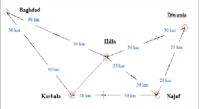
TUDYAfter identifying and formulating a number of important indicators achieved regarding to the main research problem, the reality of the services of the regional roads of three governorates of the Middle Euphrates region (Karbala, Najaf and Hilla) was investigated as a case study because of the important geographical location of this region which links northern Iraq with the south, the number of regional roads linking the region with neighboring governorates and the diversity and intensity of trips on these roads. The practical aspect of the field survey was based on GPS, GIS, and on the satellite images of the study area that are applied to eventually produce detailed and analytical maps for these services, as well as the reliance on the use of the questionnaires to reach as much as possible to the results that show us the impact of these indicators on the ideal spatial allocation of these services. Figure 1 represents the main roads connecting the three governorates and the neighboring governorates and the lengths that fall within the authorities of the roads and bridge directorates for each governorate.
Figure 1. Lengths of the connecting roads of the study area.
The research problem was addressed during the study of the real situation of three Middle Euphrates governorates (Karbala, Najaf and Babylon); the area of these three governorates is48,280 km2 which is about 11% of the total area of Iraq. Each of these governorates has a major road network which connects them with the neighboring governorates. We have selected all the main roads linking these governorates with each other and with other governorates that fall within the study area, as well as part of Highway no. 1, which it is located within the governorate of Babylon. Therefore, the research includes more than a classification of roadways, where the study area contains seven main roads, a highway,
and one part of pilgrimage road, as shown in the Table 1.
Table 1.
Regional roads located in the study area and their classification
VI. R
ESULTS ANDD
ISCUSSIONA. Analysis of spatial allocation efficiency of public road services
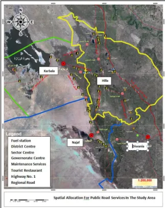
The method of spatial analysis is used to study spatial relations between the phenomena in a way that ensures the possibility of benefiting from them and determines the reasons for their distribution and allocation, as well as future prediction. And after identifying the most important elements of spatial allocation of the public road services in the study area through the identification of the locations of these services, distances between each type and the number of human settlements passes by each road as shown in Figure 2 and Table 2. It is necessary to determine the effectiveness and efficiency of each service, its suitability and compatibility with the set of indicators reached in the previous sections, through scientific analysis of these services locations with the indicators above.
Standards are one of the most important and fundamental indicators of the efficiency and sufficiency of various types of services, whether those related to community services, road
services, infrastructure services or other functions and activities that will provide adequate service to people.
The distance-based criterion implies that the proposed location (new service station) should be at most 15 km away from the nearest site (dedicated or built) for a fuel filling station or a stopping space containing a fuel filling station on the same side of the road. The proposed location should be 25 meters away from the roadside.
Figure 2. Spatial allocation of the public road services in the study area/reality
Table 2.
Distribution of public road services in the study area/reality
No. Ro a d N a m e Le n g th (K M) No o f Fu el sta tio n s No o f T o u rist Re sta u ra n t No o f m a in te n a n ce wo rk sho p To ta l N o o f S er v ice s 1 Baghdad - Karbala 50 4 1 8 13 2 Baghdad - Hilla 50 5 3 22 30 3 Karbala - Hilla 45 5 2 7 14 4 Karbala - Najaf 80 9 1 3 13 5 Najaf - Hilla 65 6 3 11 20 6 Najaf - Diwaniyah 25 5 3 1 9 7 Hilla - Diwaniyah 50 3 1 17 21 8 Karbala - Ayn Tamr 90 5 2 7 14 9 Highway 80 2 4 20 26 Total 535 44 20 96 160 Ro a d N a m e Le n g th (K m ) Cla ss ifi ca tio n Rig h t o f Wa y (m ) No . o f La n es \Dir Cities p a ss in g b y th e ro a d Baghdad - Karbala 50 Main 100 3 Haswa, Alexandria, Musayyib, Aoun Baghdad - Hilla 50 Main 100 2 Al-Haswa, Mahaweel Karbala - Hilla 45 Main 100 3 Alhindia district Karbala - Najaf 80 Main 100 3 Haidariyah district Najaf - Hilla 65 Main 100 2 Kefal, Kufa
Najaf - Diwaniyah 17 Main 100 2 Abou Sakhir Hilla - Diwaniyah 50 Main 100 2 Hashemite, Al-Qasim, Al-Tali'ah Karbala - Ayn Tamr 90 Secon
dary 100 2 Ayn Tamr Highway 80 express 250 4 ---
There are 15 settlements of different sizes between the center of the governorate and the center of the district and the center of sector (Karbala, Najaf, Hilla,Al–Haidariyah,Kufa, Musayyib, Hindi, Alexandria, Haswa, Mahaweel, Hashimiyah, Qasim, Kifl, Tali'ah, Abu Sakhir and Aoun).
Since the services of different types can be obtained within the administrative limits of the settlements along these roads, the number of these settlements will be added to the total facilities providing each of these services as this service is provided in that city or settlement for the purposes of calculating the distance between each of these service providers as follows:
Total lengths of roads = 535 km Total settlements = 15
Total tourist restaurants: 20 + 15 = 35 Total fuel stations: 44 + 15 = 59
Total maintenance workshops: 96 + 15 = 111 The average distance between each service can be derived by dividing the total length of roads by the total number of each service provider:
Average distance between tourist restaurants: 535÷35 = 15 km.
Average distance between fuel stations: 53÷59 = 9 km.
Average distance between maintenance workshops: 535÷111 = 5 km.
When analyzing the data obtained through the field survey, a number of conclusions can be drawn, the most important of which are:
The general road services in the study area are rarely all combined in one location except for one site only which is the rest stop on the Karbala – Ein Tamr road at the intersection of the pilgrimage road where a fuel station is located in addition to a large tourist restaurant and a large group of health and medical centers. On the other roadside, there are a number of shops and maintenance workshops, while a group of two services can be seen in many locations. Usually there are shops and oil change facilities near fuel stations; therefore, the distance standard cannot be applied to these services because they are not all in one location, but it can be applied to the standard on each service separately to demonstrate the efficiency of the spatial allocation to them.
The distance of 7.5 km will be adopted as a criterion for achieving the optimal spatial allocation for each service because the standard adopted in the spatial allocation must achieve a distance of 15 km between the service providers on the same road side. Thus, it is possible to take two services along the length of 15 km.
The results obtained from paragraph (1) above show that the efficiency of spatial allocation of tourist restaurants and fuel stations in the study area is outside the standard. Where the distance between the restaurants is 15 km and the distance between the fuel stations is 9 km. While we can see that the maintenance workshops are within the required standard where the distance between the workshops is 5 km.
The general road services for tourist restaurants and fuel stations are within the required standard according to the distance standard, which is 25 meters away from roadside. Maintenance services are located mostly outside the approved standard, especially when these services are provided by small shops.
Figure 3 shows percentage of total public road services(fuel stations, tourist restaurants and maintenance services) in the study area.
Figure 3 Percentage of total public road services in the study area
B. Analysis of the results according to the spatial compatibility index
The spatial compatibility means the use of modern programs and methods in selecting a suitable location for the established or new service provider, such as school, hospital, landfill, airport or public road services, with a condition that this ideal location is chosen based on a set of criteria to be available in this place. Spatial compatibility analysis is used in many engineering and geographic applications. When analyzing the results of the field survey based on the spatial compatibility index, we made a number of important conclusions:
There is a non-random distribution of the general road services of different types. It is possible to observe many fuel stations close to each other in a way that does not comply with the standard for the spatial allocation of this service, while noting big distance between fuel stations that can reduce the efficiency of this service. The approved standard distance of 5 km was adopted for the spatial allocation of the stopping place stations as a distance from the municipal boundaries of the city centers in
12,5%
27,5%
60,0% Tourest restaurant
Fuel stations Maintenance services
accordance with the regulations approved by the Directorate of Urban Planning. Thus, a zone for service provision was set within 10 km distance around the governorate centers, as well as within 5 km, and 2-5 km around districts and sector centers, respectively. The adoption of these distances is based on the service that may be provided by the centers of these cities to road users which was estimated by the researcher. The standard distance between service providers was found to make 7.5 km according to the approved controls that achieve the best spatial fit, and a zone was set around each one of these three services as shown in the maps.
1) Spatial compatibility index for fuel stations
The least convenient way to the fuel stations service due to the lack of the existing fuel stations is a high way where large gaps between the different areas can be observed, which requires increasing the number of stations, especially in the areas that are not serviced along the way.
We can observe random and unplanned distribution in both Hilla-Najaf and Haswa-Hilla road with heavy penetration of this service in part of the road and its absence in the remaining part, where we observe the overlap of these zones inextricably with each other and this is reflected on the benefit of this service.
It can be inferred from all the above that there are three roads of the study area where the distribution of fuel stations within the specified criterion is observed. These roads are (Hilla - Karbala), (Najaf - Karbala) and (Najaf - Diwaniyah) while the distribution of fuel stations in the six other roads is out of standard (not spatially appropriate).
2) Spatial compatibility index for tourist restaurants
An analysis of the spatial compatibility index for tourist restaurants in the study area indicates that there is an equal distribution of this service in most of the regional roads. The same criteria and controls that have been adopted in the spatial allocation of the fuel stations will be adopted due to the lack of specific criteria to allocate tourist restaurants spatially. These standards may be overpriced if adopted in the spatial allocation of this service because of the low proportion of demand for them, if the reliance on humanitarian standards and estimation of the period within which a person can feel hunger and thirst. It can be concluded that the spatial compatibility of these services is among the required standards,
except for some roads that are considered as high traffic density such as Najaf – Karbala road, which locates only one tourist restaurant and this does not match the size of service required on this road, especially on religious occasions and visits. The same refers to Hilla – Diwaniyah road, which includes one tourist restaurant and this may be caused by the fact that the road passes four settlements; hence, the presence of a restaurant in that area is unprofitable or uneconomical. However, if we take the distance from the road side being 75m or more, as noted above, we note that all the restaurants in the study area achieve this distance required even those on the highway No. 1, where we observed the distance of 150 meters, where the roadside is 250 meters and although the fuel stations on this road are placed within the main designs; here roadside distance is not implemented which results in the neglected terrace seating.
3) Spatial compatibility index for maintenance services
The maintenance services in the study area make the largest percentage in terms of quantity, but come in the last rank in qualitative terms.
The rules and standards relating to the spatial allocation of the rest stations specify the need for the maintenance and repair of vehicles such as workshops, oil replace shops and car wash sites, which are not available in most of the roads within the study areas.
The scope of the service impact was 7.5 km according to the standard in place. The maintenance services in the six roads of the study area are within the required standard and it is good in terms of the spatial fit of the distance between the service providers. These roads were highway, Haswah – Hilla road, Haswah – Karbla road, Hilla – Karbala road, Hilla – Diwaniyah road, and Hilla – Najaf road.
There is a clear defect in the allocation of the spatial maintenance services in three roads of the study area, namely Karbala – Najaf road, Najaf – Diwaniyah road, and Karbala – Ayn Tamr road where the proportion of maintenance services provided is low; the spatial relevance in terms of the distance criterion is not achieved.
The distance away from the roadside is not achieved in most of the road sunder study, they are located close to the edge of the road and most of them do not meet technical specifications.
The analysis of standards and spatial compatibility for the efficiency of spatial allocation of public road services showed that fuel stations and tourist restaurants fall outside
the standard, while maintenance services fall within the standard. Though, fuel stations and tourist restaurants fall within the standard in terms of the distance away from the roadside unlike the maintenance services.
C. Analysis of the questionnaire forms
A total of 216 forms were distributed to a group of drivers working on the regional roads of different types of vehicles (load, taxi, private), and some questionnaires were distributed to the passengers using these roads. A series of results were found, the most important of which include:
50%of travelers through the regional roads under study prefer to stay at the rest stations.
The level of services offered on these roads does not meet the requirements of 66% of passengers. This is consistent with the previous conclusion of the criteria.
58% of drivers agree that all necessary services for passengers and vehicles are not provided in the study area.
71% of the drivers working on these roads do not prefer to take alternative routes to the main roads either because of the lack of alternative roads, the fear of the security situation, the time factor or because alternative routes are usually not paved, while 29% preferred alternative ways to get rid of congestion.
The results of the questionnaire show the level of evaluation of the general road services by the users of the regional roads (passengers and drivers); they prove that the majority of passengers agreed that the level service rendering is low. However, the drivers agreed that the level of services is medium, as shown in Table 3 and Figures 4 and 5.
Table 3.
Results of the evaluation of the level of public road services by travelers and drivers
Very good Good Inter-mediate Bad Passengers 2% 16% 36% 46% Drivers 4% 20% 40% 36%
Figure 4. Percentage of the passengers’ assessments of the level of public road services
Figure 5.Percentage of the drivers’ assessments of the level of public road services
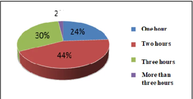
The results of the questionnaire survey showed that the views between passengers and drivers were consistent with the maximum time a passenger could take during the trip before stopping for the rest, where the two opinions were agreed that the two hours were the maximum time a person could endure and then felt the need to stay at the nearest stopping place as shown in Figures 6 and 7.
Figure 6. Percentage of the maximum time period for the passenger before stopping at the rest station
Figure 7. Percentage of the maximum time period for the driver le before stopping at the rest station
The services of fuel stations ranked first in terms of priority required by the drivers on the regional roads, they are followed by services rendered by repair workshops and tourist restaurants as shown in Figure 8.
Figure 8.Percentage of service priorities required by regional road drivers
Most of the drivers agreed that congestion is one of the most important problems facing them during their trips on the regional roads and then comes the lack of services, followed by lack of road maintenance and finally the problems resulting from climatic conditions as shown in Figure 9.
Figure 9. Percentage of problems faced by drivers on the regional roads
The results of the questionnaire survey indicate that the standard of satisfaction and acceptance of passengers and drivers on the regional roads is below the level of ambition, and that most of these roads suffer from a marked weakness in services in terms of quantity and quality.
VII. T
HEI
DEALS
PATIALA
LLOCATION FOR THEG
ENERALR
OADS
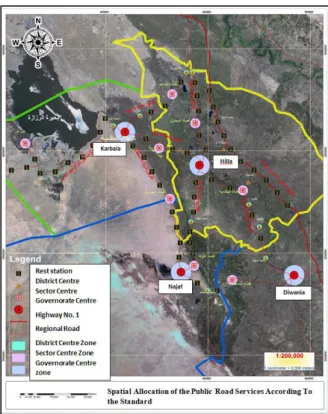
ERVICESAfter identifying the regional roads in the study area, they were classified into three types: highways, main roads and secondary roads. After identifying the controls and criteria that determine the spatial allocation of the stopping spaces, a standard map was prepared including the spatial allocation of the public road services on the basis of all roads in the study area with regard to the standard as shown in Fig 10. The two strategies were developed to improve the status of these services.
Figure 10.The spatial allocation of the public road services according to the standard approved by the
Directorate of Urban Planning
The first strategy. There are two categories of public road services or two types of stopping spaces, including the first-class and second-classs topping spaces. The first type is designed for long periods of rest and should have all the necessary services for the road users. The second-class stopping spaces are used for rest and temporary parking. They are designed for shorter time periods and should have all basic services. The number of facilities and services to be provided in each type of station varies depending on the factors mentioned above as shown in Table 4.
Table 4.
Standards proposed for public road services to be provided at the stopping spaces
The standard First class
stopping space Second class stopping space Distance between the stations km 50 km 25 Distance between the settlements km 20 km 10 Vehicle travel
time One hour Half an hour Traffic volume More than 7500
veh./day ( 2000 -7500 ) veh./day Fuel station Required Required Tourist restaurant Required Required
Maintenance
services Required Required Emergency and
aid center Required Optional Operating hours hours 24 hours at 12
Direction of
spatial allocation Round-trip Round-trip Area 1200m2 at least 600m2 at least
Pre-site guidance boards
Two boards. One board before the
station at a distance of 2km and other board at a distance of 500m. Two boards. One board before the station at a distance of 1km and other board at a distance of 400m. Parking lots
forlarge and small vehicles
Not less than 25 parking lots
Not less than 15 parking lots
The second strategy is to identify the candidate areas for development in which the demand for service is at the highest level or the most important services which are connected with the comfort of people and that are in the spread sites of tourist restaurants, where the researcher proposes to add other necessary services complementary to this service, such as fuel stations, maintenance services, parking lots for vehicles, emergency services, and communications for the purpose of reaching these sites to a degree of satisfaction and acceptability, which requires encouraging investors and capital owners to contribute to the development of these sites during the construction of modern service facilities and technologies in line with the global developments.
VIII. C
ONCLUSIONSSummarizing the presentation and study of the reality of allocating spatial services for the public roads in the study area, and the following conclusions can be drawn: -
A number of factors are directly related to the sufficiency of the spatial allocation of the public road services, which will strengthen or weaken this sufficiency, where the most important factors are the distances between the locations of service providers, the road length, as well as traffic density on the regional roads and settlements along these roads. Also, there are secondary factors that are less effective, such as the human factors associated with human endurance, the state of roads, their classification, current land uses, and climatic and environmental conditions.
The results of the field study showed that the spatial allocation of fuel filling stations and tourist restaurants are beyond the approved standards and controls, while maintenance services conform to the standards.
There is a clear variation in the efficiency of service delivery on the regional roads,
especially fuel stations, which usually close in early periods of the day or at sunset, which negatively affects the functional performance of these roads.
The existence of free restrooms that belong to the elders of the tribes that provide water, food, sleeping and health services along the regional roads leading to the holy cities (Karbala and Najaf) contributed significantly to the weakening of the volume of road services provided on these roads.
Most of the regional road users in the study area do not rely on the services provided on these roads mainly because of their inefficiency and quality, where they take precautions before embarking on trip.
There are no planning standards for each type of road and reliance on the same criteria for all types of roads that fall outside the municipal boundaries.
There is no unified and integrated system that combines the three services in one location and only the adopted scattered distribution between services can be.
IX.
R
ECOMMENDATIONS Reviewing the planning criteria for the spatial allocation of the public road services, taking into account road classification, traffic density, size and number of settlements located along the roads, and the need to adopt humanitarian, quantitative and environmental standards rather than just the distance criterion.
Considering coordination between the public and private sectors for the establishment of integrated stopping spaces that would have a fuel station, a large tourist restaurant or a fast food restaurant and shops, as well as an integrated complex for maintenance services, repair of vehicles, garage for accommodation of cars, communications services, a bureau for currency exchange and an emergency center. The fuel station and maintenance services should be on the one road side and the restaurant and other services attached to it on the other roadside.
Spatial allocation of the stopping spaces should be mediated along the distance between the settlements in order to contribute to raising the economic situation and livelihood of the population of these settlements through the operation of the existing labor and reducing unemployment, and the need not to conflict spatial allocation of these stations with the current uses of the land.
Obligating the donors of licenses and permits for operation of stopping spaces or fuel stations to continue the work of these stations to
late at night for control over the emergency and sudden things that may occur during the trip
Activating the religious tourism during the increase in the number of the stopping spaces on the regional roads linking the governorates, which are experiencing constant traffic load (Karbala and Najaf governorates).
Forming joint supervisory committees between the General Authority for Roads and Bridges, the Transport Agency and the Ministry of Health to conduct regular and sudden visits to supervise and follow up on the quality and efficiency of these stopping spaces.