• 検索結果がありません。

2D Simulation of Advection Diffusion on Ground Water Flow on Joyo city in Kyoto

N/A
N/A
Protected

Academic year: 2021

シェア "2D Simulation of Advection Diffusion on Ground Water Flow on Joyo city in Kyoto"

Copied!
5
0
0

読み込み中.... (全文を見る)

全文

(1)

2D Simulation of Advection Diffusion on Ground Water Flow on Joyo city in Kyoto

著者 Kitaoka Takafumi, Kusumi Harushige journal or

publication title

Proceeding of EIT‑JSCE Joint International Symposium in Bangkok

year 2008‑09

URL http://hdl.handle.net/10112/5742

(2)

2D Simulation of Advection Diffusion on Ground Water Flow on Joyo city in Kyoto

Takafumi Kitaoka

1

and Harushige Kusumi

2

1Graduate school of Kansai University E-mai

2 Dept. of Civil and Environment Engineering, Kansai University E-mail : [email protected]

ABSTRACT:

The research of my paper on the Ground Water is to predict the extent of the pollutant source. These research paper purposes, by making 2D model, to analyze two dimensional seepage flow, to predict ground water flow and to analyze the advection diffusion of pollutant . The area of the simulation model is located in the southern part of Kyoto prefecture, it has a typical ground water basin shape. First, I made the 2D model with examining the material of the stratum, and divided 3 kinds of layers. That is divided into alluvial formations, clay formations, and, diluvial formations from the ground level. It is because that the most important purpose of this study is to the extension of the pollution in multiple layers. I made the analysis of the each seepage flow to get the speed of a moving fluid by using 2D model I have made. The next, I made the simulation analysis of advection Diffusion of pollutant source to predict the expansion of pollutant source. This pollutant source for this research is mercury.

1. INTRODUCTION

In Kyoto, the underground water has been used for daily life for a long time, such as making tofu and dyeing kimono. Kyoto has a typical groundwater basin where there are three main rivers; Uji River, Kizu River and Katsura River. These rivers flow into the area between Tennou-zan and Otoko-yama mountains, then flow out to Osaka. For this reason, Kyoto basin saves enough underground water. Due to the fact that the underground water in Kyoto basin flows out from this point only, it is estimated that abundant underground water is saved.

The quantity of underground water is calculated to 21.1 billion tons and is comparable to the volume of water in Lake Biwa (25 billion tons). This research is focused on Joyo city which is located in the southern part of Kyoto prefecture. In Joyo city 80 percent of water for daily life comes from ground water. So, if ground water is polluted, most of the people in Joyo city will suffer from illness caused by the contamination. To predict the extent of the pollutant source, these research paper purposes, by making 2D model, to analyze two dimensional

seepage flow, to predict ground water flow and to analyze the advection diffusion of pollutant.

2. GEOLOGICAL CONDITIONS IN KYOTO

Kyoto basin is surrounded by mountains made of basement rock such as Paleozoic strata and granite, as is shown in Fig.1. These mountains penetrate into the centre of the basin with a gentle gradient.

The basement rock has a bowl shape and

sedimentary layers made after the tertiary era

accumulated on it. The basement rock is an

impermeable bed; and, upon it, there are diluvial

formations and alluvial formations consist of

alternate layers of permeable and impermeable

layers. This means that the sediment can save a lot

of underground water. The simulation model of the

area is rich in sand gravel in shallow layers (alluvial

formations), and the deeper layers consist of clay

and sand gravel.(diluvial formations)

(3)

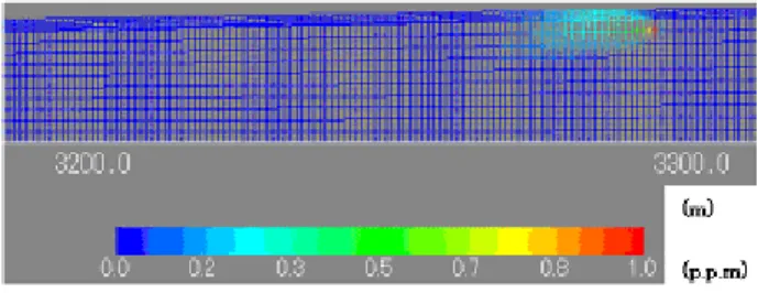
3. THE SIMULATION MODEL

The simulation model has been established by examining the material of the stratum taken from the data which is called “KANSAI GROUND INFORMATION DATABASE” in 2007. Since the most important purpose of this study is to predict the extension of the pollution in multiple layers ,we divided 3 kinds of layers.

(1) The Area of the analysis

The analysis range in Joyo is shown in Fig 2. A-A’

is the analysis range, and this simulation model is the vertical cross section, and the range is 3500m from the east to the west.

(2) Mesh division

The completed model is shown in Fig 3, Fig4 and Fig5. It is divided into alluvial formations, clay formations and, diluvia formations from the ground level. That means the model is classified by colors at the vertical section. Blue is alluvial, Green is clay, Red is diluvia. The model is divided into 13053 node points and 12199 elements.

4.THE RESULT OF ANALYSIS SEEPAGE FLOW

(1)The outline of the Seepage flow analysis

This study on 2D seepage flow analysis is FEM, and enables us to predict the speed of moving ground water flow.

(2)Boundary condition

As for boundary conditions, water fixed boundaries is set in both east and west. The east boundary is set at the average of actual ground water level, and the west is set at the average of Kizu river level.

Lake Biwa

Katsura River

Uji River

Kizu River Otoko yama Tennou zan

Fig.1 Geological profile on Kyoto basin

Fig.2 The analytical area in Joyo

(a)from end of west to 2500m point

(c)from 3200m to 3500m point (b)from 2500m to 3100m point

Fig.3 2D analytical model

(4)

(3)Ground physicality parameter

As for the physicality of the ground parameter in this study, the coefficients of permeability are 5.0E- 05(cm/s) in alluvial, 1.0E-05(cm/s) in clay, and 5.0E-03(cm/s) in diluvia.

(4)The result of seepage

Fig 6 shows the result of analysis which is conducted at the point of 1500 ~ 2000m indicated in Fig 2. This result shows the speed of moving ground water flow in alluvial is about 18 ~ 33(m/year). Another result shows the speed of moving ground water flow in diluvia is about 7(m/year). This result is used in the Advection Diffusion analysis.

5.The result of at ADVECTION DIFFUSION ANALYSIS

(1)The outline of Advection Diffusion analysis

The present study predicts how 1 p.p.m source of the contamination spreads in 50 years in alluvial of in diluvia. This analysis can predict the behavior of mercury.

(2)The result of Advection Diffusion analysis

Fig 5 shows the site where the contamination occurred in alluvial at the point of 3000 ~ 3100m shown in Fig 3(b). And Fig6 shows the one in diluvia at the point of 3200 ~ 3300m in Fig3(c).

Both results show the behavior of mercury. The extent of mercury behavior for 50 years is estimated at 35 m in horizontal direction in alluvial. The extent of mercury behavior for 50 years is estimated at 17 m in horizontal direction in diluvia.

(3)The comparison of the concentration of the contamination

Fig 7 shows the comparison of the contamination concentration between alluvial formation and diluvia formation. It reveals that the pollutant in alluvia expands more than that in diluvia. However, concentration of diluvia is denser than that of alluvial near the source of the pollutant.

Fig.4 The vector diagram for the speed of moving ground water flow

Fig.5 The result of Advection Diffusion of mercury at alluvial layer

Fig.7 The comparison of contamination consentration between alluvial and diluvial formations

Fig.6 The result of Advection Diffusion of

mercury at diluvial layer

(5)

6.CONCLUSIONS

The present study, the simulation model has been established in multiple layers. Furthermore, we succeeded to predict the ground water flow and the expansion of the pollutant. This simulation model predicts the extent of mercury behavior for 50 years is estimated at 35 m in horizontal direction in alluvial. The extent of mercury behavior for 50 years is estimated at 17 m in horizontal direction in diluvia. However, the analysis model should be made more accurately by altering the parameters.

The challenges for the future will be the improvement of the model and reviewing the hydrological parameters.

REFFERNECES

Kansai Ground Information Conference : Kansai Ground Information Database (in Japanese) CD- ROM, 2007.

2)Karlheinz Spitz and Joanna Moreno : The

modeling of Underground water Environment due

to Civil Engineers (in Japanese) Gihodo published

C. pp.328-334, 2003.

Fig 5  shows the site where the contamination  occurred  in alluvial  at the point of 3000 ~ 3100m  shown in Fig 3(b)

参照

関連したドキュメント

Ruan; Existence and stability of traveling wave fronts in reaction advection diffusion equations with nonlocal delay, J. Ruan; Entire solutions in bistable reaction-diffusion

Keywords: continuous time random walk, Brownian motion, collision time, skew Young tableaux, tandem queue.. AMS 2000 Subject Classification: Primary:

Using this characterization, we prove that two covering blocks (which in the distributive case are maximal Boolean intervals) of a free bounded distributive lattice intersect in

The author, with the aid of an equivalent integral equation, proved the existence and uniqueness of the classical solution for a mixed problem with an integral condition for

Later, in [1], the research proceeded with the asymptotic behavior of solutions of the incompressible 2D Euler equations on a bounded domain with a finite num- ber of holes,

Applying the conditions to the general differential solutions for the flow fields, we perform many tedious and long calculations in order to evaluate the unknown constant coefficients

This paper presents an investigation into the mechanics of this specific problem and develops an analytical approach that accounts for the effects of geometrical and material data on

The object of this paper is the uniqueness for a d -dimensional Fokker-Planck type equation with inhomogeneous (possibly degenerated) measurable not necessarily bounded