Received: 25 September 2018 / Accepted: 25 October 2018
© Social Science Review (2018) Saitama University, Japan
Abstract This paper is an exploratory study aimed at evaluation of the cross-border transport and trade facilitation of Greater Mekong Subregion countries. It has been ratified under the Cross-border Transport Facilitation Agreement (CBTA) since 2003. Empirical results support our hypothesis that R12 is the new- different-better route relative to R9. The study focused on the R12 route that connects the borders of Thailand, Lao PDR and Vietnam. We have employed the Exploratory Data Analysis (DEA) to construct the Cross-Border Transport and Trade Facilitation Index(TTF). It comprises measurement indicators of border-crossing facilities, prior customs formality procedures, and transport facilities for a transit of goods and people as well as road condition. The primary data was collected from a non-participation observation via Visual Inspection Rating (VIR), field survey, and in-depth interviews. Empirical findings of this study would benefit GMS, verifying the progress of CBTA development framework after 15 years of ratification.
The development of the route R12 will reduce the cost of trade among Mekong members and indirectly with the rest of the world.
Keywords Cross-border Trade, Transport and Trade Facilitation Index (TTF), R12 route JEL Classification R53, F141
1 Office of Border Economics and Logistics Study (OBELS), Mae Fah Luang University, Chiang Rai, Thailand, 57100 E-mail: [email protected], Tel: +6653916703
Acknowledgments: The authors gratefully acknowledge the support of this research from the Office of Border Economics and Logistics Study (OBELS), School of Management, and Mae Fah Luang University. We also acknowledge and thank Prof. Kenji Nozaki (Takasaki City University of Economics) and Nathapornpan P. U. for their valuable comments in improving this paper.
Evaluation of Cross-Border Transport and Trade Facilitation of R12 Route (Thailand, Lao PDR, and Vietnam): An Exploratory Approach
Warawut Ruankham
1,Naphat Rompho, Nattaphon Rangsaritvorakarn and Athitaya Pathan
《Chapter 3》 FDI, Trade, Global Value Chains and Excahnge Rates Regimes
1 Introduction
Thailand has been trading under “border trade” with four neighboring countries including Malaysia, Myanmar, Laos PDR, and Cambodia, while at the same time maintaining a "cross-border trade” with three countries namely Singapore, Vietnam and southern China. For the cross-border trade in 2018, the biggest trade partner of Thailand is currently southern China (34.15%), Vietnam (33.35%) and Singapore (32.51%) respectively. The top three export products are computers and components (48.67%), fresh, frozen and dry fruits (23.96%) as well as circuit boards (4.86%) (Department of Foreign Trade, 2018). Theses trading numbers have been increasing continuously and rose to 23.23% from 2016-2018.
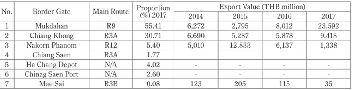
In 2018 the General Administration of Quality Supervision, Inspection and Quarantine of China (AQSIQ) granted permission of 22 additional lists of Thai fruit exports to the territory of China via the R9 route. This results in a dramatic rise in Thai fruit exported to China by 329%. In particular, the Chinese market continues demanding more and more of Thai fruits to serve its domestic demand expansion. The two biggest well-known fruit markets are located at Guangxi, Nanning and Yunnan, and Kunming respectively. The well-known exported fresh, frozen and dried fruits from Thailand are namely mangosteens, dried longans, and durians. These fruits were considered as the king of fruits in both Thailand and China. Traders have been exporting their fruits using multiple modes of transport. However, the modes of transports are varied and depending on the distance between farms to markets. Table 1, Thailand-China cross-border export values, shows the main fruits that were exported through seven border gates by four main routes. Namely, R9 and R12 were used to export fruit to Guangxi, Nanning where R3A and R3B were known for Yunnan, and Kunming.
Table 1 Thailand - China Cross-border export values classified by borders (Jan-Jun18) No. Border Gate Main Route Proportion (%) 2017 Export Value (THB million)
2014 2015 2016 2017
1 Mukdahan R9 55.41 6,272 2,795 8,012 23,592
2 Chiang Khong R3A 30.71 6.690 5.287 5.878 9.418
3 Nakorn Phanom R12 5.40 5,010 12,833 6,137 1,338
4 Chiang Saen R3A 1.77
5 Ha Chang Depot N/A 4.02 - - - -
6 Chinag Saen Port N/A 2.60 - - - -
7 Mae Sai R3B 0.08 123 205 115 35
Source: Cross-border trade statistics, DFT (2018)
After the construction of the third Thai-Lao friendship bridge in 2006, R9 has had the highest export values relative to R3A and R12 over the past ten years. This is because, firstly, the road condition itself is shorter and in better conditions compared to R3A and R3B. It also connects directly from Singapore all the way to Lang Son, Vietnam. As a matter of fact, the road is well-known among Thai exporters.
Second, exports via R9 have been supported by the protocol of inspection and quarantine requirement from Thailand to China. This has been made possible through the territory of third countries between the ministry of agriculture and cooperatives of Thailand (MOAC), and the general administration of quality supervision, inspection and quarantine of China (AQSIQ) which was signed in April 12, 2004, at Peking China. The agreement allowed the transportation of fruits without containers opening until it reached the territory of the third country. As well as, two countries were promised to use agreed phytosanitary inspection and single window inspection. This agreement benefited to the cross-border trading among Mukdahan, Thailand - Savannakhet/Savana-Xeno-DashaBay/Dan Sawan - Lao Bao, Lao PDR -Ha Tinh - Thanh Hoa-Hanoi-Lang Son, Vietnam - Youyi, China. It also included the imports of goods from the port of Youyi Guan, Guangxi Zhuan. Third, the cost of transportation via R9 is estimated to be lower compared to other routes. And lastly, infrastructures, development, and facilitation of R9 were supported by ADB, where the soft and hard facilitations for trade and transportation among Thailand, Lao PDR, and Vietnam are ready to serve the traders.
However, the study of Krishna S. (2010) stated that trading through R9 is not fully effective. This is because of two reasons. First, the physical reasons or the road condition continues to be of low quality and standards. It is also said that the road is narrow and has heavy traffic with little traffic management success. Also, the facility of the route is still low. Second, technical issues that exporters have experienced.
To clarify, there are nine issues which are 1) The transit traffic, trucks, and tractors are not fully permitted to access the territory of China and Vietnam 2) Toll fee collections in Lao is a little bit high (3-6%) 3) The mark up at China's border customs, Chinese customs set the average price of Thai fruit higher than the real market price and this increases the value of the actual VAT of 13% higher than it is supposed to be 4) Coordination of hours of operation is still not well-organized 5) Speed limits vary in different countries 6) Single-stop inspection (SSI) is difficult to achieve unless there is a personal relationship with staff 7) Unpredictable trading regulations of Lao PDR 8) Inefficient advance exchange of information, e.g., the promotion of benefits of GMS CBTA is not widely known and 9) Illegal ant trading between Vietnam and China. These conditions and unsolved issues have caused R9 to become less attractive relative to others routes. Hence, more and more studies are attempting to find better routes compared to R9. (Krishna S.
2010; Krishna S. 2011; Nucharee S. 2012; DIPT 2015)
While R9 seemed to be less attractive, the R12 route has been introduced to attract more exporters of Thailand as it could be the new-different-better route. All things considered, our study aimed to find empirical evidence to support R12, and test our hypothesis to see if R12 is shorter and more efficient than R9. Under those circumstances, we are trying to look at four supporting facts: 1) Physical fact of R12 (route distance, time and regulation) 2) road facility measurement 3) road condition measurement and 4) Trade and Transportation Facilitation (TTF) along the R12 route. The route for this study is R12 starting from the third Thai-Laos friendship bridge, Thailand to Dong Dang border, Lang Son, and Vietnam.
2 Backgrounds of Routes Development
2.1 The establishment of R 9 and R12
After GMS CBTA ratification in 2003 and construction of the second Thai-Lao Friendship Bridge, the R9 route has been introduced since then. It was first studied to form up the Nanning-Bangkok Economic Corridor by the Guangxi Academy of Social Science and Attaporn P. (2010). In 2012, a new corridor was found and named Nanning-Singapore Economic Corridor. This new corridor was established to link the Singapore port to Southern China. Then the route was officially published in Pan-Beibu Gulf Economic Cooperation Forum in the same year. The R9 route became more well-known among Thai Exporters after more and more fruits were exported through it. Under support from ADB, R9 has been constructed to elevate the connectivity of East-West Economic Corridor (EWEC) with the intention to link Moulmein, Myanmar to Danang, Vietnam as well as Singapore, Malaysia, Thailand, Laos PDR, Vietnam, and Southern China together. According to Krishna S. (2010) findings, the distance from Mukdahan, Thailand to Lang Son, Vietnam was approximately 1,090 km. with 39 hours of traveling. The border crossing covered 3 border gates namely the Mukdahan-Savannakhet, Dansavanh -Lao Bao and Dong Dange- Pingxiang. The ultimate targeted market is the fruit market at Nanning, Guangxi, China where the demand for Thai fruits is estimated as unlimited.
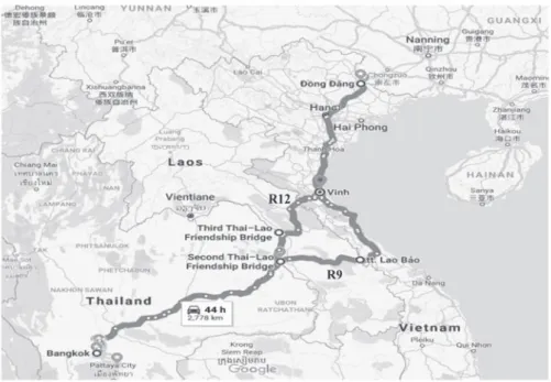
Fig. 1 Map of R9 and R12 route
Source: Online Google Map, created by authors on 20 May 2018
After the third Thai-Lao Friendship Bridge was completed on November 11, 2011, a significant amount of trading switched routes from R9 to R12. The trading via R12 has been increasing since then.
R12 was established to take benefit from the connectivity of EWEC that passes through western parts of Thailand to Lao PDR and Vietnam. This route has been known to be shorter and faster than R9 (See fig. 1).
The distance from Nakorn Phanom to Lang Son is about 800 km. which is approximately 290 km. shorter than R9. In addition, based on our exploration in May 2018, the time traveling of the R12 took around 15 hours from Nakorn Phanom to Langson. Without the clearing and transshipment time, R12 would be 24 hours faster than R9.
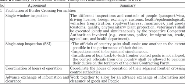
2.2 Agreement of Cross-Border Transport Facilitation Agreement (CBTA)
Greater Mekong Subregion (GMS) with the support from Asian Development Bank has initiated the GMS Economic Cooperation for its six-member countries along the Mekong River and signed the Cross- Border Transport Facilitation Agreement (CBTA). Its objectives are to facilitate the cross-border transport of goods and people between and among the Contracting Parties; to simplify and harmonize legislation, regulations, procedures, and requirements relating to the cross-border transport of goods and people;
and to promote multimodal transport. According to Instruments and Drafting History, ADB (2011) the agreements related to transport of goods and people can be summarized as table 2 shows.
Table 2 Summary of the Cross-Border Transport Facilitation Agreement (CBTA)
No. Agreement Summary
1 Facilitation of Border Crossing Formalities
Single-window inspection The different inspections and controls of people (passport/visa, driving license, foreign exchange, customs, health/epidemiological), vehicles (registration, roadworthiness, insurance), and goods (customs, quality, phytosanitary/ plant protection, veterinary) shall be executed jointly and simultaneously by the respective Competent Authorities involved (e.g., customs, police, immigration, trade, agriculture, and health department).
Single-stop inspection (SSI) ・The officials of country pairs shall assist one another to the extent possible in the performance of their duties.
・Inspections need to be joint and simultaneous.
・Installation of local back-to-back frontier control posts is not allowed, the control officials from one country shall be allowed to perform their duties on the territory of the other Contracting Party.
Coordination of hours of operation Coordinate the hours of operation of their adjacent frontier crossing control authorities.
Advance exchange of information and
clearance Work together to allow for an advance exchange of information and clearance of goods and People
2 Cross-Border Transport of Goods Exemption from Physical Customs
Inspection, Bond Deposit, and Escort Undertake to exempt cargoes in international transit from:
・Routine customs physical inspection at the border
・Customs escorts in the national territory
・The deposit of a bond as a guarantee for the customs duties
Transit Traffic ・Grant freedom of transit through territory for Transit Traffic to or from the territory of the others.
・Transit Traffic shall be exempt from any customs duties and taxes.
・Charges relating to Transit Traffic other than customs duties and taxes shall be gradually levied equally, and objectively with the same circumstances, without undue preferential treatment
P h y t o s a n i t a r y a n d Ve t e r i n a r y
Inspection Comply with international agreements related to the regulations of the World Health Organization, Food, and Agriculture Organization and Office International des Epizooties in applying inspection of goods crossing the border.
Special Regimes for the Transport of
Particular Categories of Goods The agreement does not apply for dangerous goods and the transport of perishable goods, but shall be granted a priority regime for border crossing clearance formalities, so that they may not be unduly delayed.
3 Cross-Border Transport of People
Visas People Engaged in Transport Operations: undertake to grant visas to nationals of other countries engaged in transport operations and who are subject to visa requirements, multiple entries, transit, and exit visas for prolonged periods of time.
Transport of People The performance of cross-border transport of People (such as Vehicles, transport routes, ticket pricing) will be clearly stipulated in Protocol
4 Infrastructure
Road and Bridge Design Standards ・Construction or reconstruction of the roads (including bridges) linking the countries shall be carried out within the framework of national public work programs or with international financing permitted by available financial resources.
・Ensure that roads are safe, secure, and in good conditions as well as provide necessary repairs.
Road Signs and Signals Standard traffic signs and signals on their territory
Border Crossing Facilities Undertake to build or upgrade the required infrastructure at the border crossing points to assure speedy and efficient border crossing.
5 Miscellaneous Provisions
Documentation and Procedures ・limit the number of documents, possible extensions, procedures, and formalities
・provide English translation of all documents used for cross-border traffic
・use harmonized commodity codes
・review usefulness of all documents and procedures
・eliminate any documents and formal requirements that do not serve any particular purpose
・confirm all measurements with the International System of Modem Metric Units
・advance notices for additional requirements or modifications in the prescribed documentation, and procedures to be introduced regarding cross-border traffic.
Obser vance and Enforcement of
National Laws and Regulations ・people, transport operators, and vehicles shall comply with the laws and regulations implemented in the territory of the host country.
・the host country may temporarily or permanently deny access for those who infringe the provisions of the agreement or its national laws.
・ensure transparency of legislation, regulation and nondiscriminatory treatment
Source: GMS-CBTA, Instruments and Drafting History, Yushu (2011) summarized by authors
3 Conceptual Frameworks and Methodology
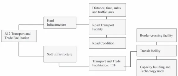
The study aimed to find empirical results based on the field survey and in-depth interviews of the logistic service providers and customs officers. There are three measurements used in this study including 1) the road transport facility measurement 2) road condition measurement which relied on the Visual Inspection Rating (VIR) method and 3) the Transport and Trade Facilitation (TTF). The conceptual framework is shown in Fig. 2 below
Fig. 2 Conceptual Framework
3.1 Methodology of Route Performance Measurements
This exploratory study aimed to measure the performance of Cross-Border Road Transport along R12 and cross-border trade facilitation of Thailand, Lao PDR and Vietnam after the GMS-CBTA ratification.
The scope of study focused on one part of East-West Economic Corridor: EWEC, especially the R12 route that connects the border of Thailand, Lao PDR and Vietnam. The total distance is approximately 800 km., starting from Nakhon Phanom (Thailand) to Khammouane (Lao PDR) and Lang Son (Vietnam). To avoid preferential bias, this study relied heavily on primary data retrieved by non-participation observation via VIR, field surveys, and in-depth interviews together with the observation from our research experts. The exploration during April-May 2018 crossed over six border gates namely Nakhon Phanom-Khammouane, Namphao-Chalo, and Dong Dang-Pingxiang border.
To represent a clearer picture of transportation performance along R12, this paper attempts to apply as many reliable measurements as possible from various subjects. With an aim to illustrate clear empirical
results, the areas of interest take into account 1) general road rules and traffic laws including highway regulations and prohibitions 2) road transport facility (standards of the route, conveniences of using the route, highway funding, telecommunications network along the route, traffic congestion, risks of using the route, signs, rest areas, gas stations, car repair shops, restaurants, accommodation hotels) applied from International Institution for Trade and Development, ITD Thailand (2012) and Tuangmalee (2015).
And 3) road condition based on Local Road Maintenance Management System (LMMS) and International Roughness Index (IRI) retrieved from Road Inspection and Assessment Manual (2018). All measurements were taken by Visual Inspection Rating (VIR) and results are classified by the road service grade as shown in Table 3 below.
Table 3 Present Serviceability Rating: PSR
Service Grade Serviceability
A Very comfortable with potholes, depressions, rutting, damaged patching, raveling and cracks B Comfortable with few potholes, depressions, rutting, damaged patching, raveling, and cracks C Acceptable uncomfortable with damages of potholes, depressions, rutting, damaged patching,
raveling, and cracks
D Uncomfortable with severe damage of potholes, depressions, rutting, damaged patching, raveling, and cracks
Source: Road Inspection and Assessment Manual (2018), Department of Rural Roads, DOT, Thailand
The measurement applied is from GMS-CBTA, Yushu (2011) and International Institution for Trade and Development, ITD Thailand (2012). In order to extend the scope of TTF developed by GMS-CBTA, this study developed the multi-dimensional, cross-border transport, and trade facility index by making an empirical survey on potentiality/readiness/efficiency for four areas: 1) cross-border trade facilitation/transit facility 2) cross-border transport facilitation and 3) capacity building and institutional reform.
TTF = f(BCF, TPF, CAP)
where TTF is transport and trade facilitation index; BCF is border-crossing or transit facility (Customs transit system and border procedures including: single-window inspection, single-stop inspection (SSI), coordination of hours of operation, advanced exchange of information and clearance); TPF is transport facilitation (exemption from physical customs inspection, bond deposit, escort, transit traffic, phytosanitary /veterinary inspection and special regimes for the transport of particular categories of goods); and CAP is capacity building and institutional reform (Training workshops and meetings, advanced information dissemination, cross-border paperless trade, ICT).
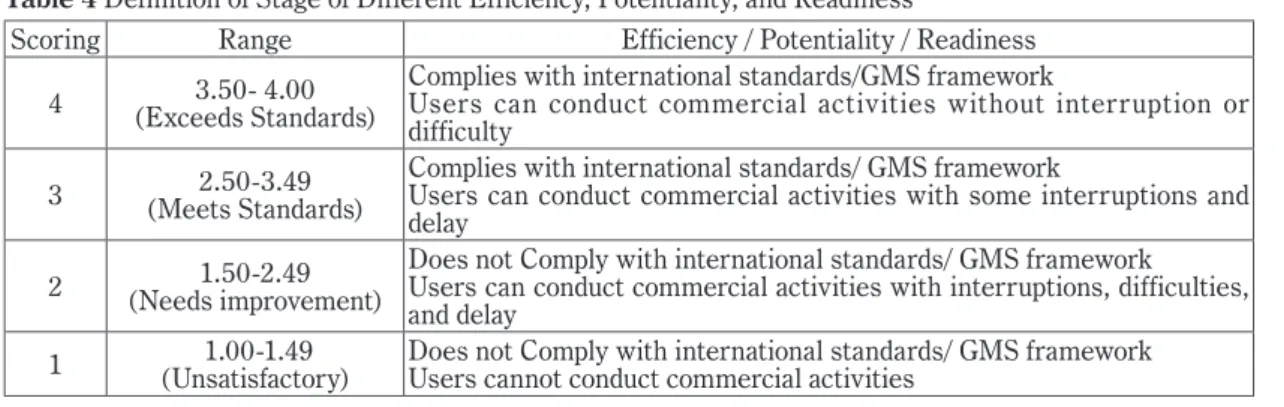
The rating scale has been applied to interpret the potentiality/readiness/efficiency of our transport and trade facilitation index (TTF) based on the GMS-CBTA and international standards as shown in Table 4.
Table 4 Definition of Stage of Different Efficiency, Potentiality, and Readiness
Scoring Range Efficiency / Potentiality / Readiness
4 3.50- 4.00
(Exceeds Standards)
Complies with international standards/GMS framework
Users can conduct commercial activities without interruption or difficulty
3 2.50-3.49
(Meets Standards)
Complies with international standards/ GMS framework
Users can conduct commercial activities with some interruptions and delay
2 1.50-2.49
(Needs improvement)
Does not Comply with international standards/ GMS framework
Users can conduct commercial activities with interruptions, difficulties, and delay
1 1.00-1.49
(Unsatisfactory) Does not Comply with international standards/ GMS framework Users cannot conduct commercial activities
Source: International Institution for Trade and Development (ITD), Thailand (2012)
4 Empirical Results
The objectives of this study are 1) to study the potentiality and readiness of road transport along R12 compared to R9 and 2) to measure the cross-border transport and trade facilitation (TTF) of six border gates along R12 starting from Thailand, Lao, and Vietnam. The empirical results are presented below.
Thus the research question is whether the new route R12 is a significantly better route especially as compared with the R9?
To answer if the R12 route is new-different-better relative to R9, the study focused on general length, time, speed, road rules and traffic laws including highway regulations and prohibitions. The potentiality and readiness of road transport facilities and road conditions of R12 were also taken into account. Knowing the potentiality and readiness of R12 will provide Thai exporters alternative choices to meet the shorter distance and lower time spent traveling. We found that R12 has potentiality and readiness due to three reasons which support our hypothesis. These reasons are 1) R12 is a shorter and faster route 2) the facility along R12 is in a substantial level which complied with GMS and international standards and 3) the transport and trade facilitation is also implied to international standard. To emphasize, greater details are presented accordingly as followed:
Table 5 illustrates the total distance and time from the previous surveys of Krishna (2010), Nozaki (2012) and Boonsap (2017). The previous studies have pointed out highlighted interesting facts on the progress of R12 over the last eight years. First, they all claimed that R12 is the shortest route compared to R8 and R9. Second, when ignoring custom clearance and transshipment time, R12 seemed to be the fastest route. And third, the latest survey from our study has found the significant improvement of customs clearance time from 2012 - 2018 where it required approximately 1-2 hours less for the customs clearance and border crossing.
Table 5 Total distance and time comparison from previous studies Route Distance
(Bangkok- Naning)
Krishna (2010)
Bankok- Nanning Nozaki (2012) Bankok-
Langson Boonsap (2017)
Bankok- Nanning
Authors (2018) Nakorn Phanom-
Langson Time(Hr.)
Customs Clearance
(Hr.)
Time(Hr.)
Customs Clearance
(Hr.)
Time(Hr.)
Customs Clearance
(Hr.)
Time(Hr.)
Customs Clearance
(Hr.)
R8 1,797 Km. NA NA NA NA 32.5 6-11 NA NA
R9 1,959 Km. 39 NA 32.8 2.6 35.0 6-10 NA NA
R12 1,694 Km. 34 NA 31.1 5.9 29.5 6-10 15 5-8
Source: Boonsap (2017), Nozaki (2012) and Krishna (2010)
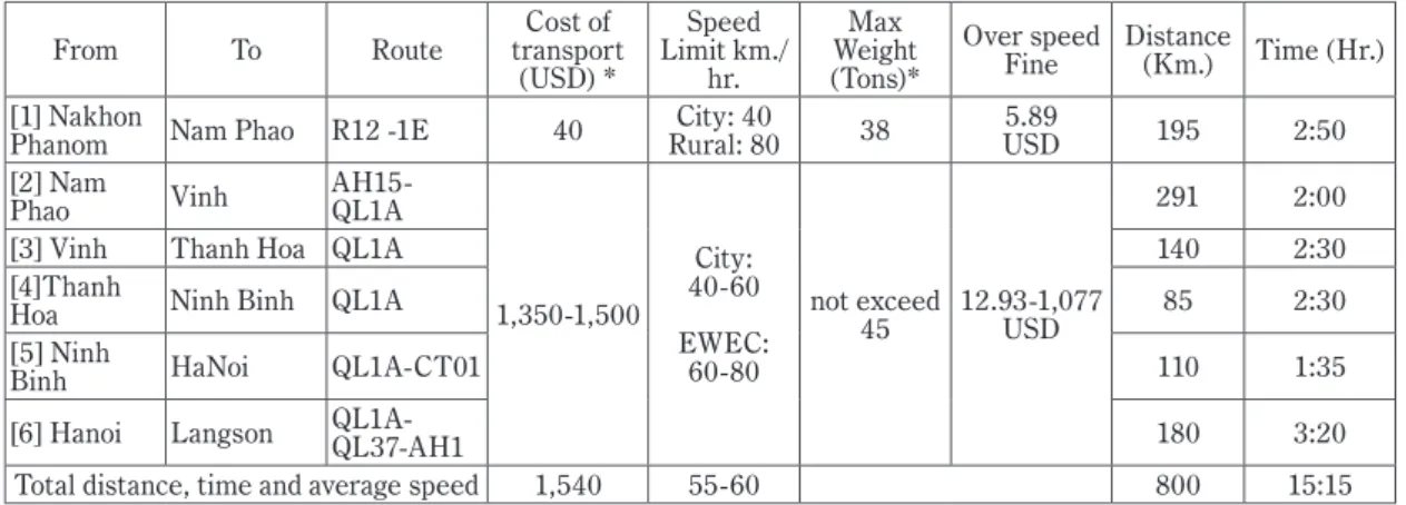
However, when looking at the regulation and some prohibitions, we found that the regulations and prohibitions were different by the authority of each country. The driver needs to pay extra attention to the speed limit, its fines, and max gross weight as it may be faster when approaching the checkpoint. (See table 5).
Table 5 Comparison of the Cost, Distance, time and regulations of Route 12 from Nakorn Phanom -Hanoi
From To Route Cost of
transport (USD) *
Speed Limit km./
hr.
Weight Max (Tons)*
Over speed
Fine Distance
(Km.) Time (Hr.) [1] Nakhon
Phanom Nam Phao R12 -1E 40 City: 40
Rural: 80 38 5.89
USD 195 2:50
[2] Nam
Phao Vinh AH15-
QL1A
1,350-1,500 City:
40-60 EWEC:
60-80
not exceed
45 12.93-1,077 USD
291 2:00
[3] Vinh Thanh Hoa QL1A 140 2:30
[4]Thanh
Hoa Ninh Binh QL1A 85 2:30
[5] Ninh
Binh HaNoi QL1A-CT01 110 1:35
[6] Hanoi Langson QL1A-
QL37-AH1 180 3:20
Total distance, time and average speed 1,540 55-60 800 15:15
Note: *cost of transport for a 20ft container, 6-axle Articulated Vehicle Source: Yushufeng (2013), Smith (2015)
(1) Lao PDR's road rules and traffic laws
The road traffic is on the right-hand side where low-speed vehicles should keep right. Thus, vehicles of Thailand need to switch lanes from left to right after passing the border gate. According to table 5, the speed limit is 40 kilometers per hour in the city area, whereas outside the city area it is allowed up to 80 km/hr., otherwise, a penalty of 50,000 LAK or 5.89 USD will be fined. All types of vehicle are required to meet the max width and height of 2.50 and 4.20 meters. The requirement age for operators of the vehicle over 3,500 kg is 18 years old. The max gross weight for a 6-axle articulated vehicle is allowed up to 38 tons. For document requirements, there are five lists of documents that must be presented: driving license, vehicle registration papers, annual road usage fee, and technical inspection and transport business
documents. However, there is a warning for drivers when driving in Lao PDR. Although the seat belt is not compulsory by Lao law, the driver is advised to keep his or her seatbelt fastened and drive at the designated speed as the road is two lanes wide. Wild animal crossings can happen unexcitingly at any time as well.
(2) Vietnam's road rules and traffic laws
Road traffic in Vietnam is at the right-hand side just as in Lao PDR. The speed limit in EWEC or outside the city area is approximately 60 - 80 kilometers per hour. The penalty for over speeding is 2-500 times higher than in Lao PDR. The 6-axle articulated vehicles are allowed to meet the max gross weight of 45 tons, which is seven tons heavier, and a max width and height of 2.50 and 4.20 meters. The age requirement for operators of vehicles over 3,500 kg is 21 years old. For document requirements, there are also five lists of documents equivalent to Lao PDR. When driving through the city area of Vietnam, drivers are suggested to be aware of motorcycles crossing the road, motorcycle accidents, and crossing animals and pedestrians.
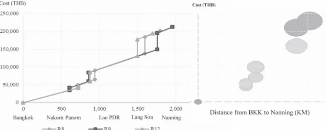
Moreover, when comparing cost- distance of R12 to R8 and R9, where the total cost comes from the cost of transport together with customs clearance, we found that R12's total cost is the cheapest route The total cost calculated from Thai Market, Bangkok to Nanning, China was 5,543 (USD) where the R8 and R9 were 5,743 and 6,057 (USD) (Boonsap, 2017). See Fig. 2 and Table 6.
Fig. 2 Comparison of Cost - Distance Matrix among R8, R9, and R12
Note: the cost of transport for a 20ft container Source: Boonsap (2017)
Table 6 Overall Cost Comparison in Utilizing Route R8, R9, and R12
Route Transport cost (USD) Cost Related to Customs Clearance (USD) Total Cost (USD)
R8 3,457 2,285 5,743
R9 3,829 2,228 6,057
R12 3,257 2,285 5,543
Source: Boonsap (2017)
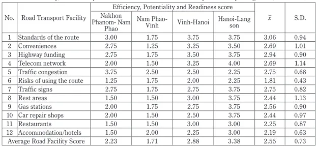
4.1 Measurement of Efficiency of Road Transport Facility along R12
The authors measured efficiency, potentiality, and readiness of road transport facility along the R12 route based on the 12 transport infrastructures. The routes were grouped into four phases: Nakhon Phanom- Nam Phao, Nam Phao- Vinh, Vinh-Hanoi and Hanoi-Langson (See Table 7). The results show that the average score of road transport facility is 2.55 out of 4, meaning that the overall score falls in the “meets the standards level” or complies with international standards/GMS framework and users can conduct commercial activities with some interruptions and delay. For example, there is a high risk of using a route with rough roads, dangerous geographical conditions or inconvenient traffic conditions/
roadside barrier. The top three potential facilities are the standards of the route, highway funding for maintenance and traffic signs. The bottoms three, which are the weakest, are risks, accommodations, and restaurants. Therefore, the GMS initiative needs to put priority into these facilities in intermediate action by persuading more investment in restaurants and accommodations as well as lowering the risk of using the route. The routes that received the lowest scores were Nam Phao- Vinh, Nakhon Phanom- Nam Phao, Vinh-Hanoi, and Hanoi-Lang Son.
Table 7 Efficiency, Potentiality and Readiness Score of Road Transport Facility along R12 (out of 4.00) No. Road Transport Facility
Efficiency, Potentiality and Readiness score
x S.D.
Nakhon Phanom- Nam
Phao
Nam Phao-
Vinh Vinh-Hanoi Hanoi-Lang son
1 Standards of the route 3.00 1.75 3.75 3.75 3.06 0.94
2 Conveniences 2.75 1.25 3.25 3.50 2.69 1.01
3 Highway funding 2.75 1.75 3.50 3.75 2.94 0.90
4 Telecom network 2.00 1.50 3.25 4.00 2.69 1.14
5 Traffic congestion 3.75 2.50 2.50 2.25 2.75 0.68
6 Risks of using the route 1.25 1.75 2.00 2.25 1.81 0.43
7 Traffic signs 2.75 1.75 2.75 3.75 2.75 0.82
8 Rest areas 1.50 1.50 3.00 3.75 2.44 1.13
9 Gas stations 2.00 1.75 2.75 3.75 2.56 0.90
10 Car repair shops 2.00 1.50 2.50 3.75 2.44 0.97
11 Restaurants 1.50 1.50 3.00 3.00 2.25 0.87
12 Accommodation/hotels 1.50 2.00 2.25 3.00 2.19 0.63
Average Road Facility Score 2.23 1.71 2.88 3.38 2.55 0.73
Source: Author's exploratory on April - May 2018
4.2 Road Conditions and Evaluation
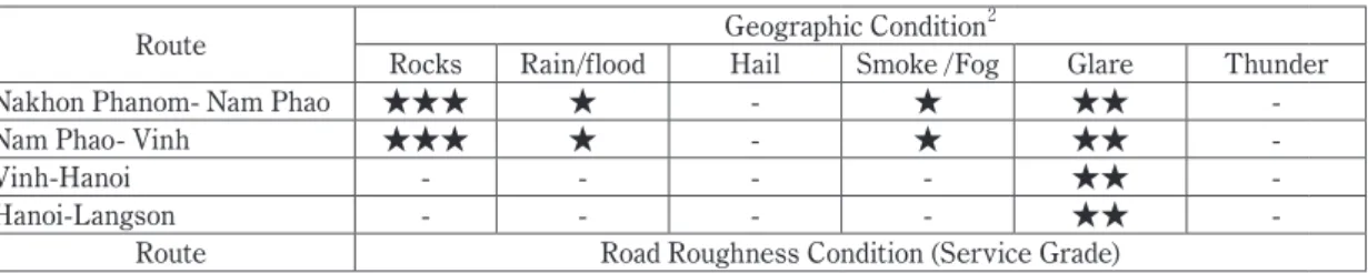
The road condition consists of three components that the driver needs to be aware of. These components are 1) geographic condition 2) roughness of road and 3) traffic conditions/ roadside barriers.
The evaluation relied on Local Road Maintenance Management System (LMMS) and International Roughness Index (IRI), and on visual inspection rating. The results were divided into two possibility indicators: level of awareness (★) from 1-3 and service grade starting from grade A (highest) to D (lowest).
As presented in Table 8, the geographic condition is one component drivers need to take extra precaution with, especially falling rocks on Nam Phao-Vinh route because it is located along the hillside.
However, the implementation of falling-rocks control was found nearby the border gates. For the rainy season, drivers need to be aware of slippery roads, especially when driving downhill as the road is narrow with no barricades or dividers provided. Accidents could easily happen if the vehicle is in bad condition such as a bad engine or malfunctioning breaks. Thus, overweight vehicles are strictly prohibited. On the other hand, there could be smoke the mining industrial areas in Lao PDR. Dust and particles as the result of stone mills or mining could easily distract or impede the driver's ability. Apart from these conditions, long-distance drivers need to be protected from the glare of the sun by wearing sunglasses, especially in the afternoon during the return drive from Lang Son to Nakhon Phanom.
Rough roads are some of the components that drivers need to be noticed as it distracts the speed and time spent driving. However, these roads are currently under construction and renovation. The rough roads consist of potholes, road depressions, rutting, bad patching from damage or weathering, raveling and cracks. Results from visual inspection rating (VIR) found that the average condition of R12 is considered a B grade, which means the overall route is in good conditions for traveling with a bit of roughness and some damages/patches. The routes after Hanoi were considered as an A grade. Its service grade is higher than the grades of Nakhon Phanom- Nam Phao and Nam Phao- Vinh. The route gets better once approaching the border area of China. However, if we look at the Nakhon Phanom- Nam Phao and Nam Phao- Vinh routes, they were considered as a C grade, as they had significant road depressions, rutting, cracks, and raveling. They also contained very bad conditions of potholes, depressions and rutting every five meters throughout the hill areas, which are located between the Lao and Vietnam border. This could be the result of inconvenient location, low-standard construction, and the heavy trucks.
Table 8 Road condition and Evaluation from Survey2
Route Geographic Condition2
Rocks Rain/flood Hail Smoke /Fog Glare Thunder
Nakhon Phanom- Nam Phao ★★★ ★ - ★ ★★ -
Nam Phao- Vinh ★★★ ★ - ★ ★★ -
Vinh-Hanoi - - - - ★★ -
Hanoi-Langson - - - - ★★ -
Route Road Roughness Condition (Service Grade)
2 ★ represents the level of awareness start from 1-3 and observed by our expert
Pothole Depression Rutting Bad Patching Raveling Crack x
Nakhon Phanom- Nam Phao D C C B D C C
Nam Phao- Vinh D C D C C C C
Vinh-Hanoi A A A B B A A
Hanoi-Langson A A A A A A A
Average grade C+ B C+ B C+ B B
Route Traffic Condition/ Roadside barriers
Animal Plants/Bush Pedestrian Motorcycle/
bicycle Agri. vehicle Traffic jam
Nakhon Phanom- Nam Phao ★★★ ★★ ★ ★ ★★ -
Nam Phao- Vinh ★★★ ★ ★ ★ ★ ★
Vinh-Hanoi - - ★★★ ★★★ - ★★★
Hanoi-Langson - - ★★★ ★★★ - ★★
Note: (-) was not found on the survey
Source: Author's exploratory on April - May 2018
For the traffic conditions and roadside barriers, we found five conditions consisting of animals, plants/
bushes, pedestrians, motorcycles and bicycles, agricultural vehicles and traffic jams. The route can be divided into two phases. The first is from Thailand to Hanoi and Hanoi to the border area of Lang Son.
Firstly, during the Nakhon Phanom- Nam Phao and Nam Phao- Vinh routes, drivers should be aware of crossing animals, e.g., cows, dogs, goats, and buffaloes together with the agricultural vehicles along the roadsides as these conditions were unpredictable. Cows and buffaloes could be found sleeping or eating grass by the roadsides. Lastly, when driving in Vinh-Hanoi and Hanoi-Langson, drivers were suggested to be aware of motorcycles, bicycles, and pedestrians, especially in the area of Hanoi where the traffic is heavily congested during rush hours. In addition, motorcycle accidents caused by trucks could take 5-15 minutes to clear up the road causing delays.
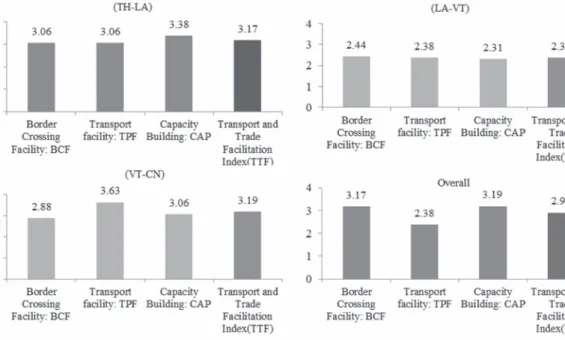
4.3 Transport and Trade Facilitation Index (TTF)
This study uses TTF as indicators representing the transport and trade facilitation at border gates along the R12. This route is expected to be the shorter and faster route compared to R9 and could be the new alternative route for Thai exporters who are willing to export to Nanning, China. The results illustrate transports and trade facilitation covering three dimensions; 1) the border-crossing or transit facility 2) transport facilitation at the border gate and 3) capacity building and technology application.
The results found that the overall TTF was 2.91 out of 4, which means that the overall facilitation is the “meets standards” level. The facilitation complies with the GMS and international standards where the trader can conduct commercial activities with some interruptions and delay. The overall Transport facility: TPF was 3.02. However, there is room for improvement in terms of Border Crossing Facility: BCF (2.79) and Capacity Building: CAP (2.92). When comparing the three borders, the border that received the highest TTF was the Vietnam-China border (VT-CN: 3.19) followed by the Thailand-Lao PDR border (TH- LA: 3.17) and Lao PDR-Vietnam (LA-VT: 2.38) (see Fig. 2).
Fig. 3 Transports and Trade Facilitation (TTF)
Source: Author's exploratory on April - May, 2018
(1) The border of Thailand - Lao PDR. (TH-LA)
The total TTF is equal to 3.17 and consists of Capacity Building: CAP (3.38), Border Crossing Facility:
BCF (3.06), and Transport facility: TPF (3.06). The overall score is in the “Meets standards” level, which means the facilitation complies with international standards/ GMS framework, where traders can conduct commercial activities with some interruptions and delay. When compared to the LA-VT and VT-CN border, TH-LA ranked no. 2 out of 3. However, there are some issues of practice faced by the Thai traders, e.g., the exchange of traffic rights and the AQSIQ agreement, which are not applicable in R12 route. Thai fruit traders need to transit their containers and change tractor heads at Lao PDR. Then, they transport the fruit to Vietnam and sell it to Vietnamese middlemen before crossing the Pingxiang border. There is a high demand from Thai fruit exporters to the Thai government, to strictly negotiate with China to add R12 into the AQSIQ agreement and cooperate with Lao PDR and Vietnam to take GMS CBTA in practice more efficiently.
(2) The border of Lao PDR - Vietnam (LA-VT)
This border has an overall TTF of 2.38 and consists of Border Crossing Facility: BCF (2.44), Transport facility: TPF (2.38) and Capacity Building: CAP (2.31). This border received the lowest TTF score compared to the rest. The overall level is in the “ needs improvement” level which means the facilitation does not comply with international standards/ GMS framework. The trader can conduct commercial
activities, but with interruptions, difficulties, and delays. The reasons for such a low level may be due to the poor coordination of hours of operation. The Lao PDR operates from 07:00 - 22:00 whereas the Vietnam border operates from 08:00-17:00. Also, the advance exchange of information and clearance takes a bit longer than another border. Also, the capacity building and technology application are still low.
(3) The border of Vietnam - China (VT-CN)
The border of Vietnam and China received the highest TTF (3.19). This is because of the Transport facility: TPF (3.63), Capacity Building: CAP (3.06) and Border Crossing Facility: BCF (2.88) are very high compared to the other borders. The overall level is in “Meets standards” level. The transport facility between Vietnam and China is very potent as they have a better trading agreement than Thailand-China.
However, there is room for improvement in coordination of hours of operation, especially on the Vietnam side in regards to expanding the times of operation (Vietnam operated between 08:00-17:00, whereas China is 08:00-20:00 o'clock). (See Table 9).
Table 9 Transport and Trade Facilitation Index (TTF)
variable Grouping Facilitation Measures Potentiality and Readiness score
x S.D.
(TH-LA) (LA-VT) (VT-CN)
BCF
border- crossing
transit or facility
[1] single-window inspection 2.75 3.25 3.75 3.25 0.50
[2] single-stop inspection 2.75 3.25 3.75 3.25 0.50
[3] coordination of hours of
operation 4.00 1.25 1.00 2.08 1.66
[4] advance exchange of
information and clearance 2.75 2.00 3.00 2.58 0.52
Border Crossing Facility: BCF 3.06 2.44 2.88 2.79 0.32
TPF transport facilitation
[5] exemption from physical
customs inspection 3.00 2.75 3.00 2.92 0.14
[6] bond deposit 3.25 3.50 3.75 3.50 0.25
[7] escort 3.75 2.25 3.75 3.25 0.87
[8] exchange of traffic rights 3.25 2.75 3.75 3.25 0.50 [9] Sanitary and Phytosanitary 2.00 1.75 3.25 2.33 0.80 [10] special regimes for particular
categories of goods 3.25 2.75 3.75 3.25 0.50
Transport facility: TPF 3.06 2.38 3.63 3.02 0.63
CAP
capacity building and Technology Application
[11] advanced Information
dissemination 3.50 2.75 3.00 3.08 0.38
[12] cross-border paperless trade 3.00 2.25 3.50 2.92 0.63 [13] Information and
communication technology 3.25 2.50 3.25 3.00 0.43
[14] Training workshops and
meetings 3.75 1.75 2.50 2.67 1.01
Capacity Building: CAP 3.38 2.31 3.06 2.92 0.55 Transport and Trade Facilitation Index(TTF) 3.17 2.38 3.19 2.91 0.50 Note: (TH-LA) refers to border of Nakhon Phanom-Khammouane, (LA-VT) border of Namphao-Chalo and (VT-CN)
border of Dong Dang-Pingxiang
Source: Author's exploratory on April - May 2018
5 Conclusion and Discussion
An Exploratory on Cross-Border Transport and Trade Facilitation along the R12 route: Thailand, Lao PDR, and Vietnam, aimed to study potentiality and readiness of road transport along R12 compared to R9, as well as to measure the cross-border transport and trade facilitation (TTF) of six border gates starting from Thailand, Lao and Vietnam. The empirical results of the study claimed that R12 is in good condition in both hard and soft infrastructure. Our findings correspond with previous research on the efficiency of R12 (Krishna S. 2010; Krishna S. 2011; Nucharee S. 2012; DIPT 2015; Smith 2015). Within
“Hard Infrastructure”, there are four empirical findings to support our hypothesis. First, the general road information, rules and traffic laws of R12 are similar to R9, but the distance and time is 290 km. shorter and 24 hours faster. Second, the overall efficiency, potentiality, and readiness of road transport facility along R12 are measured as 2.55 out of 4.00. By looking separately, Hanoi-Lang Son received a 3.38, Vinh- Hanoi 2.88, Nakhon Phanom- Nam Phao 2.23 and Nam Phao- Vinh 1.71. Thus, drivers should take extra care when driving through Nam Phao-Vinh, as the route is located in the hill areas with geographical risks. Third, road conditions are at an average level. However, there are three things to be aware of: 1) geographic risks (falling rocks, glare from the sun, flooding/rain and smog) 2) traffic conditions/ roadside barriers, animals crossing, plants/bushes, pedestrians, motorcycles/bicycles, agricultural vehicles, and traffic jams. When driving in Nam Phao-Vinh, please be aware of falling rocks, crossing animals and bushes. Also, when driving through Vinh-Hanoi and Hanoi-Langson, it is highly suggested to be watchful of pedestrians, motorcycles/bicycles, agricultural vehicles and traffic jams. Fourth, the overall roughness of the road of R12 was considered as a “B grade”. During the first phase of traveling (Nakhon Phanom- Nam Phao and Nam Phao- Vinh), the overall road roughness was considered as a lower than average or C grade.
We found that this phase contained the severe damage of potholes, depressions, rutting, bad patching, raveling, and cracks. The second phase (Vinh-Hanoi and Hanoi-Langson), was considered as an A grade and these paths contained no damage or roughness. “Soft Infrastructure”, we found that the transport and trade facilitation index (TTF) is in the “meets standards” level or 2.91 out of 4.00. The facilitation complies with international standards/ GMS framework and the trader can conduct commercial activities with some interruptions and delays.
When considering both hard and soft infrastructures, we can conclude that the R12 is “different”, but may not be able to claim if it's better or not. This will be left to the exporter's consideration. However, R12 could be the better route if the AQSIQ agreement between Thailand and China and GMS CBTA is completely implemented in regards to this route. Moreover, to pursue the sustainable development of this route, it is necessary to look into other dimensions besides economic trade and investment. As those people along the R12 were impacted by negative externality, air pollution, serious accidents caused by trucks as well as the risk of using the road; the governments of each country need to ensure that this
route provides positive externality for the society as well as social benefit, social development, social participation, and equality. For future studies, it would be very interesting to put forward the hypothesis into tourism readiness and facilitation along R12. We believe in the potentiality of R12 and that it could bring benefits to society, as well as create local economic development and provide the people along the road job opportunities.
References
Attaporn P (2010) New Trade Lane: Nanning-Bangkok Economic Corridor, 南宁-曼 谷 経 済 走 廊.Consul-General at Nanning, China Thailand Business Information Center.
Boonsab et al (2017) Information Analysis and Distribution on the Utilization of Beibu Gulf Ports, Guangxi. Royal Thai consulate, Nanning, China.
Department of Foreign Trade, DFT (2018) Cross-border trade statistics Ministry of Commerce. http://www.dft.go.th/
bts/trade-statistics.
Department of International Trade Promotion (DITP) (2015) R12 connectivity of Thailand to China, Economic Worldwide, Bangkokbiz, Vol 28, No.9846, pp7.
Department of Transport, DOT (2018) Road Inspection and Assessment Manual Local Road Maintenance Management System (LMMS), Department of Rural Roads, Thailand.
International Institution for Trade and Development, ITD Thailand (2012) Project on economic opportunity and impact of Nan-Luang Prabang route, Phayathai, Bangkok, pp 19-20.
Krishna S (2011) R12: New Economic Route from East Thailand to Southern China and the role of Vietnamese middlemen.ThaiBiz in China Thailand Business Information Center http://www.thaibizchina.com/thaibizchina/th/
articles
Nozaki K (2012) “Effects of the Third International Bridge over Mekong River on the Economic Development of Savannakhet, Laos” Surugadai Economic Studies 22(1).
Nucharee S (2012) A study on Cross-Border Trade Facilitation and Regional Development along Economic Corridors:
Thailand Perspectives in Emerging Economic corridors in the Mekong Region. BRC Research Report No.8, Bangkok Research Center, IDE-JETRO, Bangkok, Thailand.
Tuangmalee P (2015) Trade facilitation along the path of ASEAN economy: Case study of R3A route Through Lao PDR.
MFU Connexion: Journal of Humanities and Social Sciences (ISSN 2286-6477), Vol. 4 No. 1. Jan-Jul 201, Mae Fah Luang University, Chiang Rai, Thailand, pp121-147.
Smith T (2015) Regulatory direction and Import of agricultural and food products of China, Academic Seminar on Food Safety and Food Security Year 2015 Consulate (Department of Agriculture), Consulate General, Guangzhou, China.
Yushu F (2013) Operations Manual for Cross-Border Road Transport in Lao PDR, Thailand and Viet Nam: A Practical Guide for Drivers, East-West Economic Corridor, First edition. GMS TTF. http:// http://www.gms-cbta.org/online- resources.
Yushu F (2011) Greater Mekong Subregion Cross-Border Transport Facilitation Agreement, Instruments and Drafting History. Asian Development Bank, ADB Avenue, Mandaluyong City, 1550 Metro Manila, Philippines, pp 9-18.