EVALUATION OF URBAN LAND
DEVELOPMENT AND INDUCED
TRAFFIC USING THE INTEGRATED
ZONAL IMPACT ANALYSIS
September 2004
Department of Engineering Systems and Technology
Graduate School of Science and Engineering
Saga University
JAPAN
EVALUATION OF URBAN LAND DEVELOPMENT
AND INDUCED TRAFFIC USING THE
INTEGRATED ZONAL IMPACT ANALYSIS
by
Karin Limapornwanitch
A dissertation submitted in partial fulfillment of the requirements for the
degree of Doctor of Philosophy in Urban and Transportation Planning
Department of Engineering Systems and Technology
Graduate School of Science and Engineering
Saga University
JAPAN
Copyright © 2004 by Karin Limapornwanitch. All rights reserve.
EXAMINATION COMMITTEE
Professor Kazunori Hokao (Chairman)
Department of Civil Engineering
Saga University, JAPAN
Professor Masaru Kiyota
Department of Civil Engineering
Saga University, JAPAN
Professor Kazuhiko Niwa
Department of Civil Engineering
Saga University, JAPAN
Associate Professor Nobuo Mishima
Department of Civil Engineering
ACKNOWLEDGEMENTS
I would like to express my sincere gratitude to my dissertation advisor, Professor Kazunori Hokao for his invaluable guidance, numerous suggestions, and continuous encouragements throughout my Ph.D. study. Thanks and deep appreciations are also intended to Professor Masaru Kiyota, Professor Kazuhiko Niwa., and Associate Professor Nobuo Mishima for their support and for being members of the examination committee.
I am very grateful to Dr. Kardi Teknomo for his useful advice and comments as well as offering some important program developments during this study. Thanks are also extended to Dr. Ge Jian and Miss Pawinee Iamtrakul for their useful comments and discussion during the seminars.
I wish to thank the Japan Ministry of Education, Science and Culture (Monbusho) for providing financial support for the doctoral studies at Saga University. Sincere thanks are to the staffs of Office of the Commission for the Management of Land Traffic (OCMLT), especially for Mr. Surapong Meantmitr and Mr. Peerapol Sittivijan, for their kind co operations and valuable data. I am really appreciated for the important land use reports from Mr. Surasak Wongpoot from Division of City Planning (DCP) of Bangkok Metropolitan Administration. The author also would like to thank for the useful pollution data and reports from Pollution Control Department (PCD).
I wish to place on record his sincere thanks to Professor Yordphol Tanaboriboon, Professor of Civil Engineering, Asian Institute of Technology, Thailand for his constant supervision, suggestions, and encouragement given throughout the Master Course and Doctoral Course. This appreciation is also extended to Associate Professor Atsushi Fukuda from Nihon University, Japan for his valuable advices and supports for this study.
Many thanks for my Thai friends in Saga. Thank you for making me enjoy all the time that we met, particular for your Thai foods.
Most of all, I would like to express my grateful to my family. Mom, Dad, and all my older sisters, thank you very much for your love and warm supports during my long study.
I also want to thank for Miss Wandee Sutjit for her well powers that encourage me to overcome any problem during doing this research. Finally, I would like to say that all of you are so important for me. Without all of you, I cannot be a good man for today. Although, I have to live alone for long time, but I never feel lonely, because everyone always stay with me, in my strong heart. Thank you very much.
To my mother, father, and all sisters who originate my spirits to overcome any difficulty. To my sweet heart who always encourages me to keep the spirits.
“For long travels, we may face the hard time and the difficulties. We cannot see the end and do not know how to go ahead. Please keep our spirits and continue to do it, eventually we will arrive there in someday.”
Karin Limapornwanitch Saga, Japan 3 August 2004
ABSTRACT
Many efforts of urban and transportation planner have tried to integrate land use and transportation planning for years. Those efforts could be grouped into two approaches, developments of analysis tools and planning frameworks. Due to the complicated relationships of land use and transportation, and limitations of data availabilities, budget, and human resources, the development of advanced analysis tools are difficult to be implemented in poorly planned cities. Therefore, the planners in these cities have employed the planning concepts to integrate land use and transportation plans. Through planning concepts, many impact assessment frameworks have been developed and utilized as the tools to balance land developments and transportation capabilities. However, because of different analysis levels, the existing impact assessment frameworks are suitable for micro and macro planning levels only. While land use planning utilizes the zoning system to control land developments in the Mezzo-Scale, there is no any impact assessment framework to deal with the consequences of urban growths at this level. This makes the integration of transportation and land use planning becomes difficult. To fulfill this gap of knowledge, this dissertation have proposed an alternative of impact assessment approach, Integrated Zonal Impact Analysis (IZIA) framework, to improve managing urban developments, especially for poorly planned urban areas. In addition, another two interesting points were also explored through the findings of study. They include an alternative of impact integration, and the enhancement of stakeholders’ roles in land use and transportation planning.
The proposed IZIA framework consists of four main parts, consisting of the land use planning data preparation, transportation planning data preparation, zonal development impact assessment, and the participation of community in integrated impact assessment. Under this framework, the impacts are assessed and analyzed into the zonal level so that the development impacts caused any land use project can be obviously distributed into each zone. This study applied the proposed IZIA framework into Bangkapi District, Bangkok, as a case study. The shopping center project(s) was considered for the land development projects. Based on land development potentials in Bangkapi, there were three zones considered for implementing the forthcoming project. They include Zone 168, 173 and 179. To simulate the traffic impacts, the new transportation database system was
prepared into the zone-base, and eight development alternatives were created by including single and simultaneous developments, and the base case without any development project. Based on the comparisons of normalized traffic impacts among single development alternatives, it was found that the implementation of project in Zone 179, was the best alternative, because of lowest total impact index. In simultaneous alternatives, the best alternative was the case of two projects in Zone 168 and 173. The zonal impact distribution of both best alternatives pointed out Zone 170 was significantly affected by the traffic impacts of projects. The traffic impacts were considered into the further secondary impact assessments, including economic and environmental impacts. Both kinds of zonal impact assessment gave the same suitable alternatives. This might be because these secondary impacts were estimated based on traffic impact indicators, so their secondary impacts were similar to the traffic impacts. However, according to assessments of economic and environmental impacts, it was very evident that pollution impact costs were very huge social costs.
The dissertation also tried to investigate the public preferences on development impacts. There were three stakeholder groups, including residents, commuters, and visitors. Their preferences and opinions were collected through questionnaire and interview surveys. Totally, there were 1,064 questionnaires collected, but after the data verification, only 972 samples could be used as the final samples or about 91.35 % of obtained total samples.
The statistical and multivariate analysis methods, including independence tests with χ2
-Tests and Cluster Analyses, and Analytic Hierarchy Process (AHP) were employed. It was found that the public gave more value sense on the environmental issues than transportation issues. This informs that most people really want to improve the environmental conditions in the study area. The priorities of economic and environmental impacts were 0.36 and 0.64, respectively. These weights were necessary to be considered as the interrelationships between impacts in the viewpoints of social values, and they were utilized into the impact integration process. The average values of acceptable development impact levels were determined to estimate the willingness of communities for accepting such impacts. The average of acceptable travel cost for whole study areas and all stakeholder groups was 24.69 Baht/trip. The average of acceptable travel time for whole study areas was 23.35 min/trip. The useful information of community perception was provided so that an effective impact mitigation plan can be developed.
In the integrated appraisals, the dissertation has proposed an integrating way based on the interrelationship between economic and environmental impacts in the community’s viewpoints. As the results, the communities in Bangkapi gave more importance on pollution impacts rather than economic impacts, about 1.78 times. This value was called “Comparative Impact Weight”, and utilized into the integration of impacts. Based on this social value, willingness to accept integrated impacts could be estimated in order to calculate Index of Acceptance of Development Impact (IADI) for identifying the sensitive area. It was found that in single developments, Zone 170 was the sensitive area, as shown by its IADI higher than 1.00. In simultaneous developments, although there was no sensitive area, but Zone 176 and 170 occupied the highest indices compared to other zones. Particularly in Zone 170, it was emphasized that this zone was imposed by severe impacts of development project in any zone of Bangkapi. This is unfair for the people living in that zone. Therefore, planners should pay attention to mitigate the negative consequences in these areas.
In addition, the influencing factors of zonal conditions towards zonal development impacts were also investigated. The results presented that the condition of networks in each zone mainly influence on the development impacts distributed into each zone. However, the relationships were in the positive directions. This finding implies that more roads may increase more trips in the zones, so the management approaches, including transportation system and travel demand management, are necessary. Base on the public perceptions surveyed, planners in Bangkapi are recommended to provide the plans into two levels, consisting of overall and specific area levels. In the overall area level, the plans should be based on the existing conditions of land uses in each zone. As shown in the analyses, the conditions of zones can effect to the public preferences, due to their experiences in the areas. For the specific area level, it should be considered based on the stakeholders’ characteristics in each zone, including socio-economic conditions, travel behaviors, and life styles. The main goals of impact mitigation plans should be to conserve or increase the qualities of living environments.
Finally, it can be concluded that the IZIA framework is a strategic planning process to effectively control the future urban developments into the direction of livable cities.
TABLE OF CONTENTS
Acknowledgements i
Abstract iii
Table of Contents vi
Table of Figures ix
Table of Tables xiii
Chapter 1 Introduction 1
1.1 Background 1
1.2 Problem Statement 1
1.3 Objectives 4
1.4 Scope of Study 4
1.5 Expected Research Contributions 5
1.6 Dissertation Outlines 7
Chapter 2 Literature Reviews 9
2.1 The Efforts of Coordination between Transportation and Land Use Planning 9
2.1.1 The Development of Analysis Tools 11
2.1.2 The Development of Planning Concepts 12
2.2 The Impact Assessment Approach 15
2.2.1 The Concepts of Impact Assessment 16
2.2.2 Some Impact Assessment Frameworks 17
2.3 The Public Participation in Impact assessment 28
2.4 The Limitations of Existing Knowledge 30
2.4.1 The Analysis Level of the Existing Impact Assessment Frameworks 31
2.4.2 The Way of Impact Integration 32
2.4.3 The Role of Public Participation in Impact Assessment 33
Chapter 3 The Framework of Integrated Zonal Impact Analysis 36
3.1 The Traditional Land Use and Transportation Planning 36
3.2 Steps of Study 39
3.3 The Integrated Zonal Impact Analysis Framework 41
3.3.1 Basic Definitions 43
3.3.2 Background of Study Area 45
3.3.3 The Process of Integrated Zonal Impact Analysis 50
3.4 The Experimental Study 56
3.4.1 The Influencing Factors on Traffic Impact Distributions 57
Chapter 4 Land Development Impacts of Zonal Impact Analysis Model 64
4.1 Preparation of Trip Database in Bangkapi 64
4.1.1 The Validation of Trip Database 62
4.1.2 The Existing Traffic Conditions of Bangkapi 63
4.2 Traffic Impacts for Development Projects 72
4.2.1 The Estimation of New Trips of Shopping Center Project 73
4.2.2 The Traffic Impacts of Single Development Projects 71
4.2.3 The Traffic Impacts of Simultaneous Development Projects 81
4.3 Economic Impacts for Development Projects 86
4.3.1 The Travel Cost Estimation Models 87
4.3.2 The Economic Impacts of Single Development Projects 92
4.3.3 The Economic Impacts of Simultaneous Development Projects 93
4.4 Environmental Impacts for Development Projects 101
4.4.1 The Pollution Prediction Models 102
4.4.2 The Environmental Impacts of Single Development Projects 109
4.4.3 The Environmental Impacts of Simultaneous Development Projects 110
4.5 Summary 119
Chapter 5 Public Preferences on Zonal Development Impacts 122
5.1.1 Identification of Stakeholders 123
5.1.2 Questionnaire Design 124
5.1.3 Data Collection Method 122
5.2 The Analyses of Survey Results 127
5.2.1 The Public Value Senses on Transportation and Environmental Issues 128
5.2.2 The Public Opinions on Traffic Congestion and Land Developments: Cause and Consequence 131
5.2.3 The AHP and Cluster Analyses of Public Judgments on Development Impacts 134
5.2.4 The Identification of Acceptable Maximum Negative Impact Level through Public Preferences 144
5.3 Summary 147
Chapter 6 Integrated Zonal Impact Analysis 150
6.1 Pollution impact Costs of Land Developments 151
6.2 Integration of Zonal Impact Analysis 155
6.3 The Identification of Sensitive Areas towards Development Impacts 162
6.4 The Influences of Zonal Characteristics on Development Impacts 166
6.4.1 The Factor Analysis and Correlation Analysis of Zonal Characteristics 166
Chapter 7 Conclusion 166
Recommendations for Further Study 180
References 182
List of Publications 191
Appendix A: The O-D Trip Table of Bangkapi Area 193
Appendix B: The Questionnaire Form 195
Appendix C: The Specific Conditions in Each Zone of Bangkapi 201
Appendix D: The Analysis Results of Analytic Hierarchy Process 203
Appendix E: The Characteristics of Respondents in Questionnaire and Interview 209
TABLE OF FIGURES
Figure 1.1 The chapter structure of the dissertation 8
Figure 2.1 The land-use transport feedback cycle 9
Figure 2.2 The efforts to integrate land use and transportation planning 11
Figure 2.3 The developments of planning concepts and impact assessment frameworks 13 Figure 2.4 The decision making levels in Strategic Environmental Assessment 24
Figure 2.5 The integrated development impact assessments 24
Figure 2.6 The land use and transportation planning issues and the applicable impact assessment frameworks 32
Figure 2.7 The traditional integrated impact assessment 33
Figure 2.8 The main groups influencing on land use and transportation planning (a) two parties, (b) three parties. 34
Figure 3.1 The components of TIA 38
Figure 3.2 Traffic impact study example 38
Figure 3.3 The experimental and practical studies in this research. 40
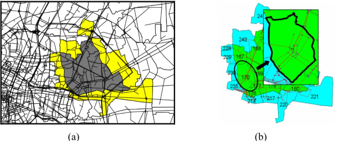
Figure 3.4 The study area of Bangkapi, Bangkok. 46
Figure 3.5 The location and networks of Bangkapi. 47
Figure 3.6 Zoning system in transportation database and populations in Bangkapi 47
Figure 3.7 The existing land-uses in Bangkapi. 48
Figure 3.8 The land-use plan and transport networks of Bangkapi areas 48
Figure 3.9 The framework of Integrated Zonal Impact Analysis (IZIA) for new traffic induced by land development projects 49
Figure 3.10 Examples of potential development areas in (a) Zone 168 and (b) Zone 179 51
Figure 3.11 The transportation databases of urban areas in (a) the existing system of macro planning level, and (b) modified into the zone-base level. 49
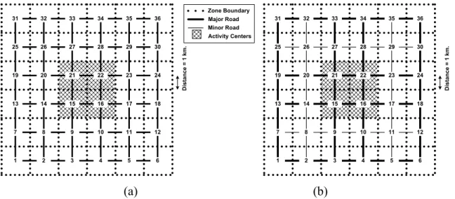
Figure 3.12 The lay out of grid city for the experimental study. 56
Figure 3.13 The grid city of numerical examples (a) all minor networks and (b) minor and major networks. 57
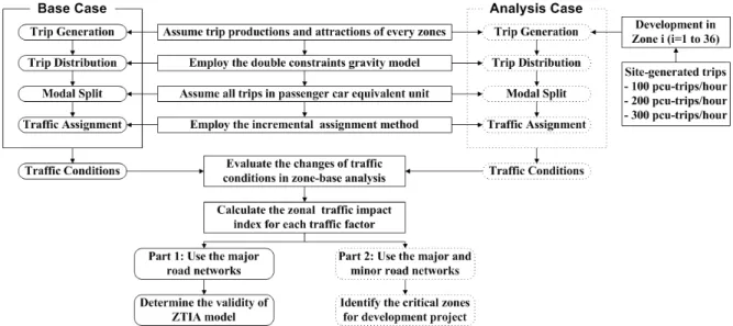
Figure 3.14 The simulation process of numerical city in the experimental study. 58
Figure 3.15 The travel delay impact index distribution for project in (a) Zone i and (b) Zone j 61
Figure 3.16 The travel delay impact index of Zone i for projects of (a) 200 and
(b) 300 pcu-trips/hour. 61
Figure 3.17 The travel delay impact index of project implemented in (a) Zone 29 and
(b) Zone 15 62
Figure 4.1 Traffic simulation to determine the traffic characteristic changes 65
Figure 4.2 The internal and external zones of Bangkapi from 520 zones of Bangkok 66
Figure 4.3 The stations of traffic volume data collection 67
Figure 4.4 The validations of simulated traffic volumes for (a) on inbound direction
and (b) on outbound direction. 68
Figure 4.5 The O-D trip distributions in the internal areas of Bangkapi areas 68
Figure 4.6 The traffic conditions during evening peak hours in Bangkapi 69
Figure 4. 7 The proportions of existing levels of (a) vehicle-kilometer,
(b) vehicle-travel time, and (c) vehicle-delay in Bangkapi for the base
case. 71
Figure 4.8 The normalized traffic impact distributions of (a) vehicle-kilometer, (b) vehicle-travel time, and (c) vehicle-delay for development project
in Zone 179 81
Figure 4.9 The normalized traffic impact distributions of (a) vehicle-kilometer, (b) vehicle-travel time, and (c) vehicle-delay in for development in Zone
168 and 173 86
Figure 4.10 The relationships of VOC rate and speed for each vehicle type in year
2003 89
Figure 4.11 The proportions of existing levels of (a) value of time costs (VOT), (b) vehicle operating costs (VOC), and (c) total travel costs in Bangkapi
for the base case 91
Figure 4.12 The normalized total economic impact distribution for project in Zone
179 97
Figure 4.13 The normalized total economic impact distribution for projects in Zone
168 and 179 101
Figure 4.14 The input data of obstacle distances and lane width for noise prediction
models in Bangkapi. 104
Figure 4.15 The monitoring station of noise pollution levels in Bangkapi 106
standard, (b) Carbon Monoxide emissions, (c) Nitrogen Oxide emissions,
and (d) Sulfur Oxide emissions 108
Figure 4.17 The normalized pollution impact distribution when project in Zone 179 for (a) noise pollution, (b) Carbon Monoxide, (c) Nitrogen Oxide, and
(d) Sulfur Dioxide 114
Figure 4.18 The normalized pollution impact distribution when projects in Zone 168 and 173 for (a) noise pollution, (b) Carbon Monoxide, (c) Nitrogen Oxide,
and (d) Sulfur Dioxide. 119
Figure 5.1 The procedures of public preference determination 123
Figure 5.2 The structure of questionnaire design 125
Figure 5.3 The distributions of public value senses on transportation issues (a) based on the zone-base analysis, (b) based on the stakeholder-base analysis. 128 Figure 5.4 The distributions of public value senses on environmental issues (a) based
on the zone-base analysis, (b) based on the stakeholder-base analysis. 129 Figure 5.5 The distributions of public opinions on traffic congestion caused by
Ineffective land use controls (a) based on the zone-base analysis, (b) based
on the stakeholder-base analysis. 132
Figure 5.6 The distributions of public opinions on pollution problems caused by traffic congestions (a) based on the zone-base analysis, (b) based on the
stakeholder-base analysis. 133
Figure 5.7 The AHP structure for the analysis (a) of targets of land development
controls, (b) of concerned impacts in the mitigation plan. 135
Figure 5.8 The public judgments on the significant roles of government and
communities for land development controls (a) the AHP priority results for the zone-base analysis, (b) the cluster analysis of the priorities from
each zone. 137
Figure 5.9 The public judgments on the importance of stakeholder groups for
impact mitigations (a) the AHP priority results for the zone-base analysis,
(b) the cluster analysis of the priorities from each zone. 138
Figure 5.10 The public judgments on the importance of impact mitigation targets for land development controls (a) the AHP priority results for the zone-base
analysis, (b) the cluster analysis of the priorities from each zone. 140
developments (a) the AHP priority results for the zone-base analysis,
(b) the cluster analysis of the priorities from each zone. 141
Figure 5.12 The AHP priority results in the stakeholder-base analysis (a) on the significant roles of government and communities, (b) on the importance of stakeholder groups, (c) on the importance of impact assessments, and (d) on the importance of impacts generated by land developments. 142 Figure 5.13 The distributions of acceptable maximum travel cost impacts generated
by land developments (a) based on the zone-base analysis, (b) based on
the stakeholder-base analysis. 145
Figure 5.14 The distributions of acceptable maximum travel time impacts generated by land developments (a) based on the zone-base analysis, (b) based
on the stakeholder-base analysis. 146
Figure 6.1 The impact integration framework for this study. 156
Figure 6.2 The integrated impact distributions of each development case 160
Figure 7.1 The position of Integrated Zonal Impact Assessment framework. 171
Figure 7.2 The proposed integrated impact assessment approach 175
Figure 7.3 The IZIA application for strategic planning 179
TABLE OF TABLES
Table 2.1 Integration of environmental concerns into development planning 18
Table 2.2 The concerned impacts in transportation system improvement in Brazil 26
Table 3.1 Conflicting orientations of land use and transportation planning 38
Table 3.2 The levels of value sense of people on a social problem. 45
Table 3.3 The land development alternatives in Bangkapi area 52
Table 3.4 The assumptions for the network shape influences on traffic impact distribution 56
Table 4.1 The overall network performances of the base case. 69
Table 4.2 The existing levels of concerned traffic indicators in the internal study zones 70
Table 4.3 The analysis cases of development impact analysis 72
Table 4.4 The characteristics of the shopping center project 73
Table 4.5 The network indicators of overall areas for each analysis case 75
Table 4.6 The zonal traffic impacts of single development project in Bangkapi 78
Table 4.7 The zonal traffic impact indices of single development alternative evaluation in Bangkapi 79
Table 4.8 The zonal traffic impact indices of development impact distribution when a shopping center project implemented in Zone 179. 80
Table 4.9 The zonal traffic impacts of simultaneous development alternative evaluation in Bangkapi 83
Table 4.10 The zonal traffic impact indices of simultaneous development alternative evaluation in Bangkapi 84
Table 4.11 The zonal traffic impact indices of development impact distribution for shopping center projects implemented in Zone 168 and 173. 85
Table 4.12 The estimated values of travel time in Baht per hour per person for Thailand. 88
Table 4.13 The average vehicle occupancy for Bangkok 88
Table 4.14 The estimated travel costs for the existing traffic conditions of base case 90 Table 4.15 The zonal travel cost impacts for single development project in Bangkapi 94 Table 4.16 The zonal travel cost impact indices for single development project in Bangkapi 95
Table 4. 17 The zonal travel cost impact indices of development impact distribution
for shopping center projects implemented in Zone 179 96
Table 4.18 The zonal travel cost impacts of simultaneous development projects
in Bangkapi 98
Table 4.19 The zonal travel cost impact indices of simultaneous development projects
in Bangkapi 99
Table 4.20 The zonal travel cost impact indices of development impact distribution
for shopping center projects implemented in Zone 168 and 173. 100
Table 4.21 The CO, NOX, and SO2 emission models of passenger car 105
Table 4.22 The observed and predicted noise levels at monitoring stations in
Bangkapi 106
Table 4.23 The estimated pollution levels from the existing traffic conditions. 107
Table 4.24 The noise and air pollution impacts for each single development case 111 Table 4.25 The noise and air pollution impact indices for each single development
case 112
Table 4.26 The pollution impact indices of development impact distribution when
a shopping center project implemented in Zone 179. 113
Table 4.27 The noise and air pollution impacts for each simultaneous development
case 116
Table 4.28 The noise and air pollution impact indices for each simultaneous
Development case 117
Table 4.29 The pollution impact indices of development impact distribution
when shopping center project(s) implemented in Zone 168 and 173. 118
Table 5.1 The measure of public value senses on transportation issue 126
Table 5.2 Number of samples (person) in the questionnaire surveys. 127
Table 5.3 Tests of independences of public value senses for each zones and
stakeholders 129
Table 5.4 Tests of independences of public opinions for each zones and stakeholders 133 Table 5.5 Tests of independences of AHP judgment for each component and zones 137 Table 5.6 Tests of independences of AHP judgment for AHP elements and
stakeholders 143
Table 5.7 Tests of independences of acceptable impact levels for zones and
Table 6.1 The noise and air pollution impact cost for base case and each single
development case 153
Table 6.2 The noise and air pollution impact cost for each simultaneous development
case 154
Table 6.3 The integrated zonal impact costs for base case and single development
alternatives in Bangkapi 158
Table 6.4 The integrated zonal impact costs for simultaneous development alternatives
in Bangkapi 159
Table 6.5 The public willingness to accept integrated impacts and the Index of
Acceptance of Development Impact (IADI) for each zone 164
Table 6.6 The considered variables of zonal conditions. 166
Table 6.7 The results of factor analysis for zonal conditions 167
Table 6.8 The correlation coefficients between socio-economic variables and
impacts 168
Table 6.9 The correlation coefficients between overall transportation
performance variables and impacts 168
Table 6.10 The correlation coefficients between specific network characteristic
variables and impacts 169
CHAPTER 1
INTRODUCTION
1.1 BACKGROUND
Apparently in many urban areas, improvements of transport infrastructures and land use regulations cannot keep pace with the speed of economic growth and urbanization. This imbalance causes to the severe traffic congestions in those cities and results to increase of the negative impacts generated by traffic, including environmental, economic, social effects, over urban area [Hayashi, 1996]. There is no doubt that lack of urban sprawl control is one of the major causes contributing to these broader adverse impact problems through the interactive mechanism of urbanization and motorization. Hokao and Mohamed (1999) explained that the control of urbanization by land use strategies is very powerful and useful in achieving objectives of congestion alleviation, environmental degradation control, and improvement of quality of life.
Particularly in weakly planned cities of developing countries, it has been pointed out that their urbanizations are very rapid and dramatic, so the integration of land-use and transportation planning is very necessary. However, up-to-date the interdependence of patterns of urban form and transportation networks still are ignored in these cities. Especially in Bangkok, the effects of land-use changes on the transportation systems, especially in term of trip generations, are not taken into account [OCMLT, 1995a], although the rapid land-use changes are easily experienced in the city. Eventually, the infrastructure planning process cannot provide transportation capabilities in serving land developments in each area of Bangkok.
1.2 PROBLEM STATEMENT
To achieve the goals of sustainable urban growths, many studies have been conducted to understand this integration of land use and transportation developments. Generally, the efforts to integrate land use and transportation planning can be separated into two development approaches, consisting of analysis tools and impact assessment frameworks. In developing analysis tools, it focuses on the land use and transportation interaction
modeling. The interaction modeling has been established for well planned cities, especially in developed countries. However, there are some limitations that make the advanced modeling approaches cannot effectively function in developing cities. The travel patterns and activity distributions in poorly planned cities of developing countries are in the organic forms, so they are very complicated, not just depend on accessibilities. The behaviors of people in such cities are not reliable and also difficult to be anticipated. These make the basic assumptions of modeling are not really true in their cities. In addition, their land use growths are very complex, because of mixed usages and very fast urbanizations [Miyamoto, 1992, Kidokoro, 1992, and Miyamoto and Udomsri, 1996]. In practices, lacks of human resources, budget, reliable necessary data, is also the obstacle of implementation. [Miyamoto, 1992].
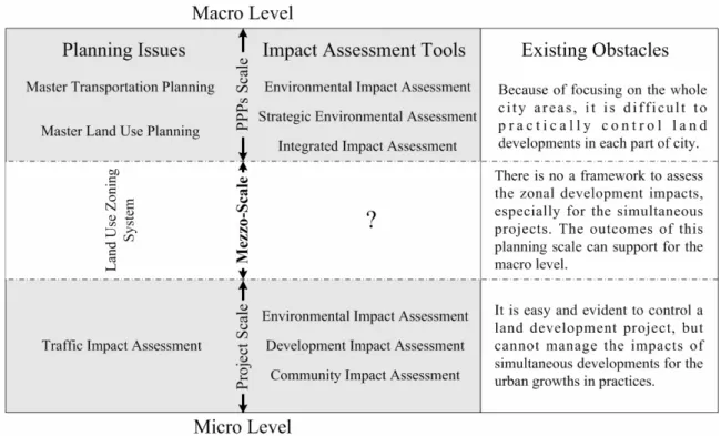
According to the modeling approach is too far from materialized in many cities, planners have tried for another approach that is the development of impact assessment framework [Gakenheimer, 1993]. Normally, it can be classified the impact assessment frameworks into two scales, macro and micro levels. The macro scale focuses on the whole city area, and the impact assessments are regularly conducted at the policy, program, and plan (PPPs)-base to provide a strategic plan. The impact assessment frameworks applied at this level include Environmental Impact Assessment (EIA), Strategic Environmental Assessment, and Integrated Impact Assessment [Pope, 2004]. For the micro level, it emphasizes the development impacts at the site area or project-base. The project-base frameworks include development impact assessment, community impact assessment, social impact assessment, and economic impact assessment. The environmental impact assessment can be modified to consider the impacts at the site level as well. For the project-base impact assessment frameworks, they employ the traffic impact assessment (TIA) to assess the effects of land uses on transportation systems [Bruchell, et al. 1994, Edwards, 2000, and Lohani et al., 1997] by considering the site impacts.
The recent progress of land-use and transportation planning integrations in developing countries is the challenges of TIA in EIA [Hokao and Mohamed, 1999 and Regidor and Teodoro, 2003]. However, the TIA application in such cities cannot effectively control urban growths to balance with the networks improvements in each area, because it focuses on development site level only. Moreover, while TIA considers a development as
a single project, the urbanization process has been resulted by simultaneous developments. At the present, the consequences of urbanizations do not affect into any specific field, but they become wide spread and various adverse effects have to be considered by planner for sustainable cities. TIA mainly focusing on traffic impacts is insufficient to manage and control other adverse impacts of land development projects.
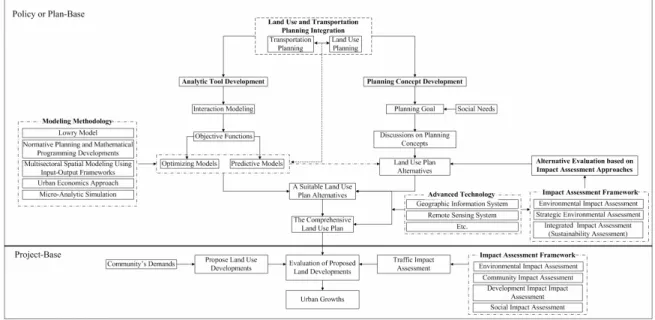
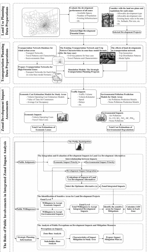
It can be understood that while transportation field consider the impacts at macro and micro levels, land use field utilizes the zoning system, the mezzo planning level, to control land developments for any part of city in practice. This creates a gap between land use and transportation planning, and makes the integration more difficult, especially in poorly planned cities. To deal with the impact analysis at the mezzo-scale, the obstacle is lack of applicable impact assessment framework. Therefore, to apply the impact assessment at the mezzo-scale and to conquer the problem of framework availability, this dissertation is conducted to propose an alternative of impact assessment, namely Integrated Zonal Impact Assessment (IZIA). Under this framework, the capability of impact assessment is extended to cover the simultaneous developments. Moreover, various impacts of urban land developments are taken into account, and eventually they have to be integrated in the assessment process.
Although, integrated impact assessment is increasingly accepted as the important issues in the planning field, but the development of a methodology for conducting integrated appraisal, and for incorporating stakeholder participation into the assessment process is still at an early stage. Most traditional integrated impact assessment methods are relied on the summation of impact assessments at decision making stage [Bond et al., 2001, Toth and Hizsnyik, 1998, Scholten and Post, 1999, and Lee and Kirkpatrick, 2001, 1997a, 1997b] without concerning the interrelation between impacts. This has been criticized that the integration should be more than the sums of separated environmental, economic, and social assessments, so that it can reflect the authentic needs of human communities [Pope et al., 2004, Eggenberger and Patidario, (2000), and Post et al, 1997]. In addition, the public power is often included in the last step of decision making. It does not really play the significant role during the integrated impact assessment process. Therefore, it can be seen that major methodological and practical issues remain to be resolved.
In the proposed IZIA framework, an alternative of integrated impact assessment is proposed. The integration process is conducted based on the public judgments or preferences. The interrelationship between impacts is included via the senses of communities. Furthermore, the public participation significantly plays the roles in integrating impacts and identifying sensitive area towards land development impacts. By using this framework, the public participation is strongly encouraged into the planning and impact assessment processes.
1.3 OBJECTIVES
The main goal of this study is to propose a strategic planning process, namely Integrated Zonal Impact Analysis (IZIA) framework, to balance land development and transportation improvements. Additionally, in order to plan for sustainable developments, The IZIA model emphasize not only specific traffic impacts of new trips generated land developments, but other secondary impacts, including economic and environmental ones, are concerned in the model. The public participation is also included into the framework of analysis so that the roles of community can be encouraged for managing the urbanizations of their city. Under the goals, this research work specially aims to achieve the following objectives;
• To develop the framework of Integrated Zonal Impact Analysis in balancing land developments and transportation improvements.
• To propose an alternative of integrated impact assessment for development impacts.
• To propose an identification process of sensitive areas towards land development impacts based on the preferences of communities in each area. • To apply the proposed IZIA framework into Bangkapi District, Bangkok as a
case study.
• To identify a suitable land use development alternative in Bangkapi District for mitigating the traffic impacts of development project and others secondary impacts of economic and environmental aspects.
1.4 SCOPE OF STUDY
The study area is Bangkapi District in Bangkok area. The research does not focus on the kind of development project, but it is more emphasized on traffic impacts, and its secondary impacts, including environmental and economic impacts. The traffic noise and air pollution are focused in the environmental impact assessment, while the economic aspect concerns on travel costs consisting of travel time and vehicle operating costs. To assess the environmental and economic impacts, the study employs the secondary data from reliable sources. In identifying sensitive areas towards land development impacts, to estimate willingness to pay for the additional costs caused by new development projects, it is calculated by acceptable level of maximum impact costs from the surveys, and number of trip production and attraction in a zone. For the integrated impacts, though social impacts are not considered, but the social component is included into the study as the interrelationship between economic and environmental impacts based on the preferences of communities.
1.5 EXPECTED RESEARCH CONTRIBUTIONS
This research intends to improve the coordination of land use development and transportation capabilities through propose a new strategic planning process, Integrated Zonal Impact Analysis (IZIA) framework. This process is expected as the unambiguous and flexible of simulation approach, especially in the cases of weakly planned cities. The expectations of research are that an integration alternative of land use and transportation planning can be established together with the development of a methodological alternative for integrated impact assessment. Under these expectations, some specific research contributions are described as following;
• The traffic impact assessment base has been changed from the local network base into the zone-base of city. It enhances the capabilities of impact assessment approach to consider for the intermediate analysis level between land use and transportation planning. This proposed framework will help to balance land use developments and transportation improvements by considering land uses and transportation networks provided in each zone.
• As the results of zone-base analysis, the traffic impacts can be exemplified into the assessment of secondary impacts, including vehicle operating costs and travel time costs for economic impacts, and air and noise pollutions for environmental impacts. In the present, these impacts are seriously considered into the sustainable developments of city, and planners cannot ignore them from the planning issues. • As explained before that most traditional approaches of integrated impact
assessment are in the weak degree of integration, the integrated impacts are just the summation of separated economic, environmental, and social impact assessments. The interrelationship between impacts is not considered, thus they do not reflect what the society really needs. Under the proposed framework, the relationship between impacts can be determined and clarified obviously through the surveys of public judgment.
• The critical issue of public participation in urban planning process is also considered into the integrated appraisal of IZIA framework. The stakeholder power is not included in the planning process at decision making step only, but it will play the important roles in the impact assessments. Moreover, their willingness towards development impacts is also determined and utilized to identify a sensitive area towards land development impacts. It can be seen that the community is encouraged to show more powers on the urban planning of their city. • By using IZIA framework, the study intends to identify the sensitive area towards
development impacts. This sensitive area is useful for planners to realize that which zone should be paid attention more seriously for alleviating development impacts in the viewpoints of communities. The area stands for the community that has low willingness to accept the adverse impacts of development project, but they have been imposed by severe impacts. Particularly in the case that the community does not earn the benefits of project directly, planner should crucially mitigate such undesired impacts for them as the social welfares.
In practical viewpoint, its contribution can be realized as the tool and data availabilities, especially when compared with the modeling approach of transportation and land use interaction planning. Most basic tools and necessary data of IZIA framework are possibly afforded in developing cities.
1.6 DISSERTATION OUTLINES
This dissertation consists of seven chapters as shown in Figure 1.1. The first and second chapters are Chapter 1 and Chapter 2, respectively. In Chapter 1, it aims to explain the problem statement of research together with the objectives and scope of study. Chapter 2 provides the reviews of literatures related with this dissertation, and it points out three limitations of existing knowledge, including the analysis level of the existing impact assessment frameworks, the role of public participation in impact assessment, and the way of impact integration. These limitations are fulfilled by the study of Chapter 4, Chapter 5, and Chapter 6, respectively.
Chapter 3 aims to explain the study process of research and the framework of Integrated
Zonal Impact Analysis. The steps of study are described into two parts, including experimental and practical studies. The experimental study is conducted to provide some basics of zonal impact analysis. The Integrated Zonal Impact Analysis (IZIA) framework is introduced in this chapter. The last part of this chapter is devoted for the results of experimental study. Some findings are useful to be discussed for the other chapters.
In Chapter 4, it mainly focuses on the results of application of IZIA framework in the real world case study. The simulation processes of traffic impacts caused by development projects are described. The impact assessments of traffic, economic, environmental impacts, are conducted separately. In evaluating the impacts, the impact prediction models of each kind of impacts are discussed in details. Moreover, all zonal impact assessments have to be performed separately for single and simultaneous development alternatives, respectively.
The investigation of public preferences on zonal development impacts is performed in
Chapter 5. The data collection of communities’ opinions is described step by step. After
the process of data acquisitions, the obtained data are verified and analyzed by various
methods, including the tests of independences by Chi-squared Tests (χ2-Tests), Analytic
Hierarchy Process (AHP) method, and Cluster Analysis method. The results of analyses provide the useful information, such as stakeholder perceptions on economic and environmental impacts caused by land developments, the importance of impacts in their senses, the relationships between judgments and stakeholders or zones etc. These findings
provide the important interrelationship between economic and environmental impacts that utilized into the process of impact integration, and some useful information in strategic planning of impact mitigation measures.
Chapter 6 emphasizes on the integration of economic and environmental impacts that
had been evaluated in the previous chapters. Before conducting the integration, the evaluation of environmental damage costs is explained. The public preferences in Chapter 5 are considered again in this chapter as “Comparative Impact Weight” to be employed in the equation of integrated impacts. Moreover, the public willingness to accept the consequences of land development alternatives will be quantified to identify the sensitive area. The zonal characteristics are also determined their influences on the zonal impacts generated by land development project. This helps to understand that which criteria can influence on zonal development impacts and how different zonal conditions created different impact severities.
Finally, the conclusion of dissertation is drawn into Chapter 7 as the last chapter.
CHAPTER 2
LITERATURE REVIEWS
This chapter intends to review previous studies related with this research. Some efforts of land use and transportation integration planning were reviewed in the approach of analytic and planning ways. Together with the experiences of land use and transportation planning in developing countries, some limitations were explained. As the impact assessment approach is recommended to be an alternative to solve the problem of integrating land use and transportation planning, so some concepts of impact assessments are reviewed, especially for integrated impact assessments. Under the integrated appraisals, the stakeholder powers are concerned as the key components, therefore it is necessary to understand the basic concepts of public participation in urban and transportation planning fields. Based on the literatures of impact assessment frameworks, the existing limitations of knowledge are discussed to point out the importance of this study. These details of reviews are described into the following paragraphs.
2.1 THE EFFORTS OF COORDINATION BETWEEN
TRANSPORTATION AND LAND USE PLANNING
It is palpable that both transportation investment and urban development have the close relationships, as shown in the urbanization histories of many cities around the world. The set of relationships between transportation and use can been summarized as the land-use transport feedback cycle in Figure 2.1.
Weneger (1995) explained that the distribution of land-use, such as residential or industrial area, can determine the locations of human activities, such as living and working. In addition, these distributed human activities in spaces will require spatial interactions or trips the transport system to overcome the distance between the locations of activities, therefore the distribution of transportation infrastructures can create opportunities for spatial interactions that can be measured as “accessibility”. Finally, this is seemed to be the distribution of accessibility.
To integrate land use and transportation planning, some efforts have been exhausted into two parts, consisting analytical tool developments and planning concept developments as shown in Figure 2.2. In the analytical tool developments, the interactions between transportation and land use sides must be taken into account to develop the theories of interaction modeling. The developed models are utilized by planners as the tools to provide the perceptions on the relationships between the characteristics of activity areas, including land use type, size and location, and their access demands. The predictabilities of land use and transportation interactions are useful for planner to shape and optimize the benefits of urban growths or diminish the adverse effects of land developments. It can be seen that the interaction models can play the roles as the powerful analysis tools to determine the influences that both planning fields affect to each other. For the developments of planning concepts, they concern the ways to evaluate the advantages and disadvantages of land development alternatives. Afterwards, they try to implement the most suitable alternative in the context of land use plans. It can be seen that what planners try to achieve is the planning process to determine the impacts of existing and proposed land uses on transportation networks in term of trip generation. They attempt to directly coordinate land use and transportation planning through limiting land developments or improving the networks in developed areas. The interactions between land use and transportation are not included into the consideration, so the system is considered as the static system that is in the equilibrium stage [Blunden, 1971, Bates, 1999]. In addition, the integration efforts in Figure 2.2 can be also separated into two planning scales, large and small scales. The former focuses on the whole city areas or macro level, most actions are considered as the policies, plans and programs (PPPs). Sometimes, the outcomes of this planning level are implemented for strategic plans to control the urban growths by accomplishing the desired planning targets [Ravetz, 2000]. The later considers at the
specific site level, so it becomes the project-base analysis. The land use and transportation modeling significantly influence in the level of PPPs, while it becomes less influences in the project-base. On the contrary, the planning concepts, particularly in term of impact assessments, can considerably play the evaluating and monitoring roles in both levels.
Figure 2.2 The efforts to integrate land use and transportation planning Source: Author.
2.1.1 THE DEVELOPMENT OF ANALYSIS TOOLS
As explained before, the efforts in this part have been mainly dedicated for developing interaction modeling. Regarding the functions of models, the land use and transportation models can be classified into optimizing and predictive models. The optimizing models aim to optimize urban system or components rather than to concern about the travel behaviors of people in the city. They can be informative for research and long term planning, but in general they are difficult to link to the practical planning problems of individual cities or regions [Bates, 1999]. The predictive ones try to predict the location of activity areas and possible travel patterns in the future. Most of models are relied on the predictions of future activity and trip distributions, because their results are more reliable. If consider in theoretical and methodological standpoints, these interaction models can be classified into 5 approaches [Engelke, 1995], consisting of Lowry Model , Normative Planning and Mathematical Programming Developments, Multisectoral
Spatial Modeling Using Input-Output Frameworks, Urban Economics Approach, and Micro-Analytic Simulation. The desired land use plan alternatives can be created and evaluated through these advanced models. In some policies or plans, alternatives of land use plans are developed by the models, and evaluated by the process of planning concepts or frameworks in the way of impact assessments and project evaluation.
All of the modeling approaches try to catch the basic concept of behavioral interaction. Some criticisms, however have tended to revolve around (1) conceptual issues of model realism and hence usefulness; (2) practical issues of data availability and quality, as well as computational requirements and ease of use; and (3) the role such models are to play in the planning process [Engelke, 1995]. Particularly for practical issues, Lee (1994) argued that in the study of land use and transport interaction, planners may be trying to get too much detail into the models. As planners add more detail and functionality to what are already rather ambitious models, they loose flexibility in the application and increase expensive data requirements. This point is more obvious when it is considered in the cases of developing countries. As lack of tracing the evolution of land development and transportation infrastructure improvement, therefore the availability of such necessary data for modeling is seem to be extremely difficult in those countries. In addition, the land use and transportation relationship in these countries are too complex to be modeled into the proposed interaction modeling concept. As the general models are assumed that activity location distributions are mainly depended on the accessibility distributions (See Figure 2.1), but it has been argued the modeled land use and transportation interactions are true, when the accessibilities is a scare commodity only [Cervero, 1989, and Landis, 1996.]. In developing cities, because of inexpensive transport, little planning control and a deregulated land market, the relationships are much more complicated [Miyamoto, 1992, Kidokoro, 1992, Miyamoto and Udomsri, 1994, Cervero, 1989, and Landis, 1996].
2.1.2 THE DEVELOPMENT OF PLANNING CONCEPTS
In fact, urban and regional planning theory and the theory and practice of impact assessments have largely proceeded along parallel but separate paths, particularly in environmental impact assessment (EIA) [Lawrence, 2000]. For years, the frameworks of impact assessments have been utilized to determine the impacts of land uses on
transportation fields, and the effects of transportation projects on generating land developments. Definitely, the applications of impact assessments are not limited in the viewpoints of land use and transportation only, but the other fields are also extended to earn the optimized benefits of projects, such as in controls of pollutions caused by development project, decrease of social intensions in opposing any public project, etc. However, the other applications are beyond the scope of this dissertation.
To understand the characteristic of each impact assessment framework, it is useful to discuss about the evolution of planning concepts and developments of impact assessment frameworks. On the mainstream planning theories, they can be briefly classified into 5 concepts, including rationalism, pragmatism, socio-ecological idealism, political-economic mobilization, and communications and collaboration. During the evolutions of these planning concepts, the impact assessment approach have been created as the parallel tools in evaluating and controlling of urban and regional planning as shown in Figure 2.3. Most impact assessment approaches have been originally developed based on the environmental impact assessment (EIA).
Figure 2.3 The developments of planning concepts and impact assessment frameworks Source: Authors (Combined from Lawrence, 2000, Lee and Francis, 2001, Pope et al.,
2004, and CALTRANS, 1997).
By the 1960s, the rational planning concept was progressively refined with the addition of a problem, need, or opportunity to be addressed; goals, objectives, and criteria; the
generation and evaluation of alternatives; and explicit links to implementation. The EIA process was generally paralleled with the rational planning process by sharing many characteristics, positive and negative tendencies of rationalism. However, at this stage the problem definition, formulation of goals and objectives, and generation of alternatives in the EIA process were ambiguous. Second, it is the pragmatism planning, a normative planning theory, starts from the premise that knowledge-based experience should guide planning action. According to this planning approach, it motivated the EIA to become more pragmatic through streamlining, harmonization, procedural integration, and scoping. Implementation, impact management, and EIA quality and effectiveness were paid much more attention by planners. These resulted to improve both theory and practice of EIA, particularly for the establishment of development impact analysis (DIA) framework.
Third, Socio-ecological idealism (SEI) was generated since 1970s to reintegrate social and environmental substance into the planning process. SEI was broadened to address relationships among the human, built, and natural environments, and to integrate environmental values and ethics. These interests led the planners to concern the issues of integrated impact assessment (IA), and just recently they have been extended to the sustainability assessment (SA) [Pope, 2004]. The concerns of additional social and ecological impact components are evident in life cycle assessment (LCA), strategic environmental assessment (SEA). Fourth, Political-economic mobilization (PEM) is a reaction against the lack of political and economic substance with rationalism. PEM involves active and direct political action by individuals, groups, and movements. PEM has a particular concern with social, economic, and environmental justice, unequal power relations, community empowerment, and the need for structural change. In this planning concept, there was no obvious development of impact assessment framework, but it could be realized that during this period the interests of social impact assessment (SEA) and EIA were stimulated again. Fifth, the communications and collaboration (CC) is the most recent planning theory. Under this concept, the collaborative planning is a central feature of EIA theory and practice. Principles and methods for public education, involvement, and shared decision making are well developed. Eventually the framework of community impact assessment (CIA) is established to effectively include the stakeholder powers into the planning process.
As shown in Figure 2.2, the mentioned impact assessment frameworks can be utilized to appraisal the urban development impacts into two levels of city planning, policy, plan program (PPPs) and project levels, as well. In the PPPs level, IA and SEA have been utilized to consider the impacts for the overall urban areas [Pope, 2004]. Not only the impacts of a land use project are evaluated, but they consider the total conditions of land use characteristics of the city. The interaction models are employed to generate an optimum land use growth pattern based on the evaluation of total impacts, including economic, environmental, social, and integrated impacts. The outcomes of IA and SEA frameworks are taken into account to develop the strategic plan, that usually called comprehensive or master plan. However, the framework of regular EIA is also available to evaluate the impacts of urban developments in metropolitan areas, such as in Bangkok, Manila, etc. To evaluate the impacts of a land development project, some impact assessment frameworks have been established to deal with the specific impacts and influenced parts of city areas. These project-base frameworks include development impact assessment, community impact assessment, social impact assessment, economic impact assessment. The environmental impact assessment can be modified to consider the impacts at the site level as well. For the project-base impact assessment frameworks, they employ the traffic impact assessment (TIA) to assess the effects of land uses on transportation systems [Bruchell, et al. 1994, Edwards, 2000, and Lohani, 1997] by considering the site impacts. The TIA also plays the important roles in the contexts of development planning, planning of urban centers and local areas, and regional planning [Wisdom and Henson, 2002].
It can be seen that many frameworks of impact assessment approach have been developed to deal with various issues of urban planning, not only for integrating land use and transportation planning. Therefore in the next sections, it is useful to discuss on the impact assessment concepts to provide some background and limited knowledge in the field.
2.2 THE IMPACT ASSESSMENT APPROACH
There are so many objectives for future planning of growing city, not only minimization of traffic congestion. They also include air pollution control, provision of affordable
housing, maximization of economic development, minimization of taxes and fees, preservation of historical and cultural sites, provision of adequate utility infrastructure, minimization of change, provision of adequate education and safety [Balling et al, 1999]. In fact, it is impossible to develop plans that achieve all objectives, and trade-off must be made based on the relative importance of one objective against another. The impact assessment is a tool to control the consequences of project and help to meet the targets of project. It can eliminate or relieve the adverse impacts of any project. The considered impacts of a project do not concern on traffic impact only, but also include the environmental, economic, social impacts into the lists of assessment. In addition, some researchers tried to include all types of impact for simultaneously assessing impacts of a project, so called “integrated impact assessment”. In this section some studies of impact assessment were reviewed, while the conceptual assessment was also explained.
2.2.1 THE CONCEPTS OF IMPACT ASSESSMENT
Impact assessment as a systematic field of study has its origins in the U.S. National Environmental Policy Act (NEPA) that became law in 1969. This law requires an environmental impact statement (EIS) be submitted for any project or development that would incur environmental impacts. It is very difficult to give a perfect definition of impact assessment, as impact assessment is an art rather than a science. Vanclay and Bronstein (1995) defined impact assessment as “the prediction or estimation of the consequences of a current or proposed action”. A more elaborate definition is provided by Treweek (1995) within an ecological context. He describes ecological impact assessment as “a formal process of defining, quantifying, and evaluating the potential impacts of defined actions on ecosystems”. These two definitions, however, emphasize the predictive capability of impact assessment. Westman (1985) identifies two major components in impact assessment. They are impact analysis, which is objective identification, quantification, and summarization of the occurrence of impacts; and impact evaluation, which is a subjective process of determining the significance of impacts based on the results of impact analysis.
Barrow (1997) explained that the assessment of impacts depends on human perception, something that is complex and not static. The impact assessment should concern with the
continued welfare of people and the stewardship of nature and society. Although the target of impact assessment is to flag negative impacts of a project, it has to point to potentially beneficial opportunities also. The emphasis tends to be on the avoidance of problems, but impact assessment can also help ensure that benefits are fully realized. It is important to stress that impact assessment should consider all possible alternative, include no development project alternative, to make no change. Communities and governments should utilize the impact assessment, because it offers a chance of keeping away from the public sector having to pay to rectify environmental and socio-economic impacts often caused by the private sector. Especially in Asian developing cities as Bangkok. Jakarta, Manila etc., such kind of this situation was often occurred for development projects, such as shopping centers, residential projects, theaters etc. Many attempts at developments have been “Faustian bargains” – they sacrifice long-term well being for short-term gains often obtained at the expense of damage to the environment or to people’s physical and mental welfare [Barrow, 1997].
People tend to react toward environmental and social threats in one of three general ways [O’ Riordan and Rayner, 1991]:
• Preventive Approach: It means that people think nature is fragile, and it is morally wrong to abuse nature.
• Adaptive Approach: It means that people think nature is robust, and it is morally wrong to curtail development.
• Sustainable Development Approach: It means that people think nature is robust, with in limit, it is morally imperative to preserve nature enough not to reduce choice of options for the future.
The impact assessment should emphasize a preventive, systematic, holistic, multidisciplinary approach to environmental protection and sustainable development. Furthermore, it should be also predictive and feed into planning, so that beneficial modification is possible, but in practice the application is often retrospective and stock-taking.
2.2.2 SOME IMPACT ASSESSMENT FRAMEWORKS
To provide more perceptions on the impact assessments, some impact assessment frameworks were reviewed and summarized into this section. The study briefly explained
for three frameworks, including environmental impact assessment (EIA), strategic environmental assessment (SEA), and integrated impact assessment (IA) (or sustainability assessment-SA). Most case studies that explained in the literatures focus on the impact assessment in transportation and infrastructure projects.
The Environmental Impact Assessment (EIA)
EIA was first established in developed countries in the early 1970s, because the realization of failures to consider unfavorable impacts of economic development activities. They have adopted EIA processes to examine the social and environmental consequences of projects prior to their execution. The purpose of these processes is to provide information to decision makers and the public about the environmental implications of proposed actions before decisions are made. An environmental impact is defined as an estimate or judgment of the significance and value of environmental effects on physical, biological, social or economic environment [Lohani, et al., 1997].
EIA can play the important roles in resolving the environmental problems through its ability to contribute to environmentally sound and sustainable development. Particularly for developing cities like in Bangkok, Manila, Jakarta, the EIA processes have been incorporated into development planning. The application of EIA can be classified into four scales, consisting of national, regional, sectoral, and project levels as shown in Table 2.1.
Table 2.1 Integration of environmental concerns into development planning
Level Integration of Environmental Policies and Procedures Environmental Assessment Planning or Management Techniques Used
• Environmental profiles
National Environmental policy included in national action plan • International Assistance Agency Country Programming
• Integrated regional development planning • Land use planning
Regional Economic-cum-environmental development
• Environmental master plans • Sector environmental guidelines Sectoral Sectoral review linked with other economic sectors
• Sector review strategy • EIA
Project Environmental review of project activities EIA procedures
• Environmental guidelines
The aim of national planning is to set broad economic, environmental, and social development goals for the country’s continuing development. At this level, mechanisms employed include the formulation of a national conservation strategy, environment and natural resources management plans, state-of-the-environment reports, environment and natural resources profiles for developing countries and incorporation of environmental and natural resources considerations in economic planning and national development plans. These activities are specific elements of the overall national environmental policy.
Regional planning defines broad land use allocations for a geographic region, normally at the subcountry level. At the regional level, the approach should integrate environmental concerns into development planning. This approach facilitates adequate integration of economic development with management of renewable natural resources to achieve sustainability. It fulfils the need for macro-level environmental integration, which the project-oriented EIA is unable to address effectively. Such regional plans can set the context for project-level EIA. In considering regional plans, the environmental impacts of alternatives need to be assessed.
At the project planning level, EIA is the primary tool for integrating environmental considerations into project design and execution. Project proponents and regulatory agencies prefer to consider the environmental impacts of a single project. Ideally, EIA at the project level should take place in the context of regional and sectoral level planning; if this is not feasible, the scope of EIA reports may have to consider broad land use issues. In addition, if environmental effects are considered only at the project level, decision makers will have difficulty taking account of cumulative environmental effects. These are impacts which may appear minor for any one project, but which become significant when groups of related projects are considered together. The absence of regional and sectoral planning increases the time and cost involved in the preparation of the EIA report and project approval.
Sectoral planning focuses on the needs of individual development sectors (for example, energy, transport, and forestry). At the sectoral level, environmental guidelines and sectoral reviews and strategies should be formulated and integrated into various sectoral plans. This will help to address specific environmental problems that may be encountered