地域地質研究報告 5万分の 1地質図幅 新 潟 (7)第103号 NJ‑54‑30‑1
宇 都 宮 地 域 の 地 質
吉川敏 之 ・山元孝広 ・中江 訓
平 成 22 年
独立行政法人 産業技術総合研究所
地質調査総合センター
〔修正〕第 6.2図
年代 (+)
゜
酸素同位体比I
(‑) 段丘河川堆積物最低位段丘河川堆積物男体今市・七本桜テフラテフラ 田原段丘河川堆積物一 男体小川テフラ赤城鹿沼テフラ 赤城行川第1テフラ
‑ ‑ ‑ ‑ ‑ -—、 -‑ ‑ ‑ ‑ ‑ ‑ ‑ ‑ ‑ ‑ ‑ ‑ ‑ ‑ ‑ ‑ ‑ ‑ ‑ ‑ ‑ ‑ ‑ ‑ ‑ ‑ ‑ ‑ ‑ ‑
10万年前
20万年前
30万年前
40万年前
7.1
9.3
赤城水沼第2テフラ 宝木段丘河川堆積物
日光東赤田テフラー 一 白'尺段丘可川堆積物 日光満美穴テフラ
ー 赤城水沼第7テフラ
野大沢段丘河川堆積物
I
赤城水沼第9・ 10テフラ 日光行川テフラ 鹿沼段丘河川堆積物
飯士真岡テフラ 鬼怒沼黒田原テフラ
榛名宮沢テフラ
l
宝積寺段丘河川堆積物恨元13テフラ ,3- - - - -
— + ‑ ‑ ‑ ‑ ‑ ‑ ‑ ‑ ‑ ‑ ‑ ‑ ‑ ‑ ‑ ‑ ‑ ‑ ‑ ‑ ‑ ‑ ‑ ‑
艮元14テフラ 上欠段丘河川堆積物
位 置 図
7 新 潟
日 本i海
tJ
i r
.
9
ヽ・
山 r
}
)
.I
^`ー/ 形 )
i
県 . J.!
新
^
\ ] 9ゾ9ン ︐, 1 , \ー
),.ふ1
i 、一へ.、 r
• I
} \.s・
ッ•ヽ,·
潟 /し'
. l '
︵
︷.
県 I 'ー・
◇
福 島 県
/ 口 / ‑ .栃 木 県.r•ク(• ~——` |¥
103 宇都宮
f \ r : ヽ ︑
ソj̀ f
t '
ー︐1
r ,
︑ ノ
()は1:200,000図幅名
5万分の1地質図幅索引図
Index of the Geological Map of Japan 1 :50,000 塩原ShiobaraJ :75,000 (1955)
7‑90 7‑91 7‑92
日光 矢 板 喜 連 川
Nikko Yaita Kitsuregawa NJ‑54‑29‑8 NJ‑54‑29‑4 NJ‑54‑23‑16
(未刊行, unpublished) (未刊行, unpublished) (未刊行, unpublished)
7‑102 7‑103 7‑104
鹿 沼 宇 都 宮 烏山
Kanuma Utsunomiya Karasuyama NJ‑54‑30‑5 NJ‑54‑30‑1 NJ‑54‑24‑13
(未刊行, unpublished) (2010) (未刊行, unpublished)
8‑7 8‑8 8‑9
栃 木 壬 生 真 岡
Tochigi Mibu Moka NJ‑54‑30‑6 NJ‑54‑30‑2 NJ‑54‑24‑15
(] 961) (未刊行, unpublished) (未刊行, unpublished)
宇都宮地域の地質
吉川敏之*・山元孝広* ・中江 訓*
地質調査総合センターは1882年にその前身である地質調査所が創設されて以来,国土の地球科学的実態を解明する ため調査研究を行い,その成果の一部として様々な縮尺の地質図を作成・出版してきた.その中で5万分の 1地質図幅 は,独自の調査に基づく最も詳細な地質図ヽンリ ーズと位置づけられ,基本的な地質情報が網羅されている.「宇都宮」地 域の地質図幅の作成は,この地質図幅作成の一環として行われたもので,環境保全,地質災害軽減等の基礎資料として 活用されることを目的としている.
本地域の調蒼・研究は平成16 19年度に実施された野外調査とその研究報告の作成にあたっては,地形,後期白亜 紀—古第三紀火成岩類,新第三系第四系完新統を吉川が,第四系更新統と完新統の一部を山元が, 足尾帯ジュラ系を中 江が担当したまた,全体の取りまとめは吉川が行った.
野外調査に際し,大成鉱山工業(株)及びフバサミクレー(株)には稼行中の鉱山への立ち入りと露頭観察及び試料採 取を許可していただいた.栃木県商工労働観光部工業振興課には,資料の閲覧.複写に際しご協力いただいた.本研究 で使用した薄片は,広報部地質標本館の野神貴嗣氏(現環境安全管理部),大和田朗, 佐藤卓見,福田和幸の各氏の製作 に よ る ま た,珪藻化石の同定は,地質情報研究部門の柳沢幸夫氏による.これらの方々に深く感謝申し上げる.
本報告で用いるABCD/GSJRl2345は,著者の採取番号/地質調査総合センター岩石標本登録番号を示す なお,本 図幅では, 2009年に国際地質科学連合 (IUGS)が新たに定義した第四紀の下限 (2.588Ma)を使用した.
(平成21年度稿)
所 属
*地質情報研究部門
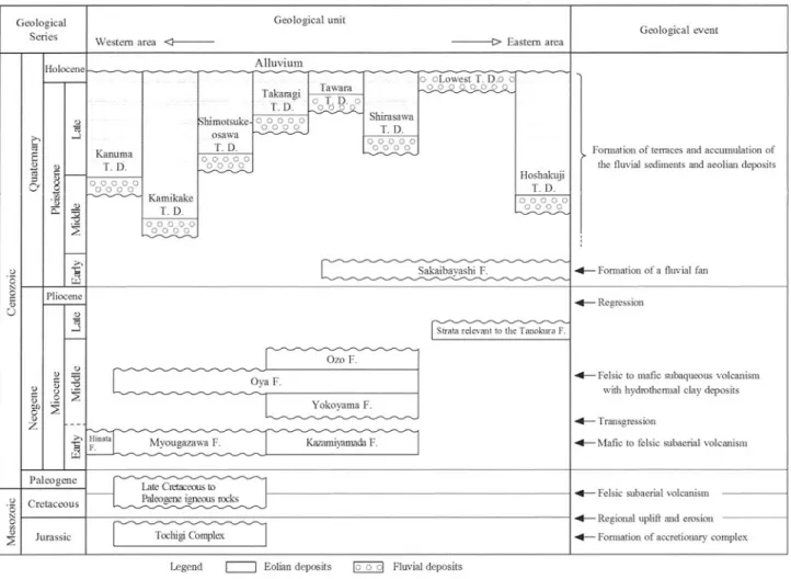
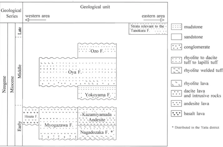
Keywords: geologic map, 1 : 50,000, Utsunomiya, Tochigi, Jurassic, Cretaceous, Paleogene, Neogene, Miocene, Quaternary, Pleistocene, Holocene, Ashio Terrane, volcanic rocks, microgranite, Myogazawa Formation, Kazamiyamada Formation, Yokoyama Formation, Oya Formation, Ozo Formation, intrusive rock, Tanokura Formation, Hinata Formation, Sakaibayashi Formation, Kamikake Terrace Deposit, Hoshakuji Terrace Deposit, Kanuma Terrace Deposit, Shimotsuke‑Osawa Terrace Deposit, Shirasawa Terrace Deposit, Takaragi Terrace Deposit, Tawara Terrace Deposit, Alluvium, hydrothermal deposits, Oya‑ishi, Kanuma‑tsuchi