River Flood Modelling under Limited Data Acquisition using PWRI Hydrologic Model
著者 Lee Fong Amaly
year 2020‑03‑31
学位授与機関 関西大学
学位授与番号 34416甲第787号
URL http://doi.org/10.32286/00021334
1 A thesis submitted to Kansai University, in partial fulfilment of
requirements for the degree Doctor of Philosophy, 2020 March
River Flood Modelling under Limited Data Acquisition using PWRI Hydrologic Model
By
Amaly Fong Lee
Graduate School of Societal Safety Sciences, Kansai
University
River Flood Modelling under Limited Data Acquisition using PWRI Hydrologic Model
2
Abstract
One of the most used hydrologic models for flood modelling, even when the available historical data is limited, is the one proposed by The Public Works Research Institute (PWRI). However, the accuracy of the PWRI Hydrologic Model highly depends on the process followed to introduce the data of rain as well on the calibration of the model; been the last the main reason why no so many researchers still interested on the model.
This thesis aims to develop a new methodology for predicting floods in cases where the data is limited. IFAS software, which is based on the PWRI hydrologic model, is used to model and simulate the flood events. In the first part of the thesis, the sensitive analysis of data required for flood modelling is performed. Then, the extent to which existing data sources can meet these requirements is evaluated in detail. After that, a parametric study is conducted to identify the influence of each parameter affecting the model in the final predicted flood. The topography of the river basin, the river basin discretization, the river watershed delineation, and others are studied in detail, and new ways to define each of them are introduced. Aikawa and Makiogawa rivers were used as studied cases through several historical flood events. Based on these studies, we present a new methodology for modelling the river flood using PWRI Hydrologic Model.
The results showed that the proposed methodology is suitable since it significantly improves the accuracy of the flood simulation when using the PWRI model. In addition to the above, this improvement of the PWRI model allows researchers to concentrate their attention on only the key factors running the PWRI model, adding efficiency and reducing computational time to the model.
In conclusion, we can stand that through the development of this research thesis, the IFAS Software has been significantly improved, allowing flood prediction more accurately even under limited historical data.
3
Acknowledgments
First, I wish to express my most profound appreciation and gratitude to my supervisor, Professor Yoshiaki Kawata, for his expert advice on my research work and instructive guidance on my academic study. His guidance and enthusiasm were a constant source of encouragement. I am very fortunate to be his student, and my training under him will be valuable throughout my life. I really appreciate his effort in reading and correcting the manuscript.
I would like to express my sincere gratitude to Professor Seiji Abe for his valuable opinions, his patience, constructive discussions, and for reading and correcting the manuscript.
I would like to thank Hydro-soft Technology Institute, Co., Ltd, Japan, for providing the IFAS software as well to Mr. Moriura, Mr. Nishimoto, and Dr. Koji Kawasaki from for all his support during this research.
I especially want to thank my friend and fellow student, Ehara Ryuji, who helped me with his extensive knowledge, with his experience and above all who made possible the development of my thesis work by providing me with the information available from the Aikawa and Makiogawa basins.
I would also like to express my gratitude to all my fellow lab mates for all the help over the past few years.
I also would like to express my thanks to the staff of Kansai University for their cooperation. I would like to acknowledge the financial support provided by the Panamanian government, which enabled my studies in Japan.
I would like to acknowledge the encouragement of my family and friends, especially my daughter Behati without whom this thesis would never have been completed.
Finally, and most importantly, I want to thank my husband, Adan; not only for the support he has given to me but for keeping me motivated, for being the support for the entire duration of my studies, for giving me his scientific point of view, his understanding and his sincere love, words are few to thank you.
River Flood Modelling under Limited Data Acquisition using PWRI Hydrologic Model
4
Dedication
Le dedico todo el esfuerzo de estos años, a mi abuela Eugenia, quien desde el cielo me cuida y me protege.
I dedicate all the effort of these years to my grandmother Eugenia, who passed away, I miss her very much.
5
Contents
Abstract ... 2
Acknowledgments ... 3
Chapter I ... 9
Introduction ... 9
1.1 Flood overview ... 9
1.2 Classification of floods according to their origin ... 10
1.3 Principle of floods ... 12
1.4 Literary Review ... 17
1.5 Methodology ... 30
Chapter II ... 32
Flood Analysis ... 32
2.1 Introduction ... 32
2.2 Influence of the physiographic characteristics in the Floods ... 32
2.2.1 Soil Characteristics: infiltration capacity, infiltration rate ... 33
2.2.2 Geometry Features: slopes, slope, and altitude ... 33
2.2.3 Vegetation and other disturbing elements... 34
2.2.4 Land use ... 34
2.3 Influence of the meteorological process on the Floods ... 34
2.3.1 Classification of Floods from the point of view of meteorological processes ... 35
2.4 Application of Geographic Information Systems to flood analysis ... 36
2.4.1 Advantages of Geographic Information Systems in Flood analysis ... 39
River Flood Modelling under Limited Data Acquisition using PWRI Hydrologic Model
6
2.4.2 Digital Elevation Models ... 40
2.4.3 Raster data resolution ... 41
2.4.4 Obtaining raster data ... 42
2.4.5 Hydrological Model (rain-runoff) ... 43
2.5 IFAS Software... 45
2.5.1 A brief history of IFAS ... 45
2.5.2 IFAS Fundamentals ... 46
2.5.3 Advantages of IFAS ... 47
2.5.4 Disadvantages of IFAS ... 49
2.6 The PHWR-DH Model ... 50
2.7 References ... 57
Chapter III ... 58
Determination of the main parameters affecting the flood prediction by the PWRI-DH Model ... 58
3.1 Introduction ... 58
3.2 Methodology for calibration of the PWRI-DH model ... 64
3.3. Conclusions ... 74
3.4 References ... 74
Chapter IV ... 77
Influence of Cell Size on Flood Modelling ... 77
4.1 Introduction ... 77
4.2 Case of Study ... 77
4.3 Influence of Cell Size on PWRI-DH Model ... 78
4.3.1 Relationship between Cell Size and the Topography of the River Basin . 79 4.3.2 Relationship between Cell Size and the River Delineation ... 82
4.3.3 Relationship between cell size and Vegetation Cover ... 84
7
4.3.4 Relationship between cell size and Efficiency ... 87
4.3.5 Relationship between cell size and the Parameters ... 89
4.3.6 Relationship between cell size and Computational time ... 92
4.4 Conclusions ... 96
4.5 References ... 97
Chapter V ... 98
Influence of the DEMs on floodplain delineation ... 98
5.1 Introduction ... 98
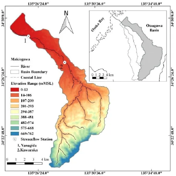
5.2 Study Area and Dataset ... 100
5.3 Modelling of Flood by PWRI hydrologic model ... 101
5.4 Methods ... 101
5.5 Results ... 103
5.6 Appropriate Grid Size ... 113
5.7 Conclusions ... 114
5.8 References ... 115
Chapter VI ... 116
Conclusions and Future Work ... 116
6.1 Conclusions ... 116
6.2 Future work ... 119
Bibliography ... 120
ANNEX 1 ... 131
Modelling of Flash Flood using IFAS ... 131
A.1. Introduction ... 131
A.2. Flash Flood Modeling ... 132
A.3. Flood Model Setup ... 132
A.4. Sensibility Analysis ... 133
River Flood Modelling under Limited Data Acquisition using PWRI Hydrologic Model
8 A.5. Conclusions ... 141 A.6. References ... 142
9
Chapter I
Introduction
1.1 Flood overview
It is well known that water is one of the most precious natural resources, due to the various social, economic, and environmental benefits that it provides to man. However, water can have the opposite effect when one of them is mixed with other components, resulting in natural disasters such as floods.
Of all-natural disasters, floods are the most destructive in terms of impact on humans (Hausmann and Perils, 1998; Proverbs and Soetanto, 2004; Schanze, 2006). During the last 30 years, the number of natural disasters has increased considerably worldwide, with floods increasing, these have affected about 2 billion people, and it is estimated that there have been economic damages of more than 400 billion dollars (EM -DAT, 2009).
However, it has been said that floods are of ecological importance for ecosystems, since they are part of natural dynamics and many species depend on them (Poff, 2002).
In addition to the above, the flooding of lands with houses, industries, agricultural and livestock activities implies the diffusion of substances and products whose use, under normal conditions, does not represent a risk to water quality, but which, as a result of an episode of flooding, they become dangerous derivatives thereof, with potential effects on the health of citizens and affected ecosystems.
It is considered a flood to the flow or the temporary covering of the terrestrial surface by water that is outside the normal confinement limits (ARC, 2007). Floods are generally a direct consequence of hydrometeorological phenomena, due to excess water (precipitation) concentrated in surface runoff or accumulation in flat terrain, caused by lack or insufficient drainage; although, in many cases, they are induced by human action
River Flood Modelling under Limited Data Acquisition using PWRI Hydrologic Model
10 (SEGOB, 1991; Salas and Jiménez, 2004) and others cause (Kawata, 1994). Even when rainfall is a predominant factor, we cannot fail to recognize that its evolution is influenced by global warming (Kawata, 2008a). The magnitude of a flood depends on the intensity of the precipitation (amount of rainfall in a given time), its distribution in space, and the duration of the rain (Salas and Jiménez, 2004). Also, the size of the watershed influences, as well as the characteristics of its drainage, topography, edaphology, and soil cover (Hewlett, 1969; SEGOB, 1991).
1.2 Classification of floods according to their origin
Their origin can classify floods in storm floods, river floods, coastal floods, and floods caused by failures in hydraulic infrastructure (Salas and Jiménez, 2004).
• Rain floods
They are a consequence of precipitation; these occur when the land has become saturated, and surplus precipitated water begins to accumulate, being able to remain hours or days.
Its main characteristic is that water only comes from local precipitation (water that comes from the upper part of the basin is not contemplated).
• River floods
They occur when the water that overflows from the rivers is on the surface of the surrounding land. It differs from rainfall in that these consider both local and those that occurred somewhere else in the upstream river basin.
• Coastal flooding
They are generated when the sea level exceeds its average level by an increase in the tide, which causes the water to penetrate inland, covering large areas of land. The flow can be generated by hurricane or cyclone winds. Also, an abnormal swell in the ocean may be caused by factors such as tsunamis (earthquakes).
11
• Flooding due to hydraulic infrastructure failure
These are less frequent and more serious than other types of floods when the capacity of the hydraulic infrastructure is insufficient, and even more so when these are designed to protect the population. The flood and the damage caused by the failure of said structure will be much higher than if it did not exist. Due to poor infrastructure design, lack of previous studies of hydrological characteristics, or inadequate maintenance or operation, the damage will be more extensive.
1.2.1 Classification of floods according to the time at which the water is evicted
Floods can also be classified by the time when water is expelled by the basin, which is called the Basin Response. The hydrological response of a basin depends on various physical and biological factors. These factors will affect the speed with which the water drops, causing slow and sudden flooding. Slow floods mostly cause property damage and can last from hours to days. On the contrary, unexpected or sudden floods have a short duration (from minutes to a couple of hours) and mainly cause loss of human lives (Salas and Jiménez, 2004).
1.2.1.1 Slow floods
When precipitation manages to saturate the water ground, for its duration, rather than for its intensity, the volume of water remaining drains through the drainage network of the basin, gradually increasing its flow. This type of flooding occurs in basins, where the slope of the causes is small, and its topography is not very pronounced. This type of flooding also occurs when the land cover helps infiltration and retention of water, causing the water to descend more slowly. Slow floods can be forecast when the presence of meteorological systems that can generate significant rainfall is identified. However, the lack of meteorological instruments that show the information in real-time does not allow to anticipate these events (Salas and Jiménez, 2004).
River Flood Modelling under Limited Data Acquisition using PWRI Hydrologic Model
12 1.2.1.2 Flash floods
This type of flooding is the result of sudden and intense precipitation events that occur in very localized areas within the basin, which causes significant and violent streams of water to be formed in a short time, causing considerable damage to its passage. These currents are also known as sudden avenues. These types of floods are difficult to predict since the events that originate them are short and intense (Salas and Jiménez, 2004).
Many of these floods occur near small streams, these events can take unsuspecting people, as suddenly an avenue can appear without signs of precipitation in the inhabited area, since precipitation may have occurred kilometer away, or in high in the basin (NOAA and NWS, 2002).
1.3 Principle of floods
Floods are categorized as events of disasters caused by nature. For various organizations related to the environment, floods are the worst disasters of this type. The World Meteorological Organization points it out as one of the most lethal phenomena (FF Guidance 2010), causing millions of dollars annually in property losses and damages.
Data that agree with NWS (National Weather System) statistics that place it as the second cause of fatalities after those caused by heatstroke (NWS 1995-2003). In Europe, it is considered one of the most important natural hazards, causing serious risks to life and destruction of buildings and infrastructure (Gaume 2008). (Baredo 2007) detailed that floods cause 40 % of the fatalities caused by disasters in the period 1950-2006.
If we consider that natural phenomena, in general, have an estimated cost of 40 billion euros (Munich Re, 2003) versus the expense of a single flood event such as that of Gard 2002 with 1.2 billion euros (Huet et al., 2003) we can demonstrate the economic impact of this type of phenomenon. Water is an essential element for living, but it is dangerous and destructive when it becomes a flood (Vivirolo, 2003).
Floods are also defined as an increase in the level of water that occurs when an event that generates a volume of water, in a short time, such as the breakage of a reservoir or a dam collapse.
To specify the time that characterizes the flood the NWS (National Weather System, USA) limits the maximum time of occurrence from 3 to 6 hours and defines it as: “A
13 rapid and extreme elevation of water in a dry area, or fast and extreme increase in the level of water in a stream or stream that is above the predetermined level of flooding originating within 6 hours of a causative event.”
Floods are also often defined as an intensive hydrological response of a basin due to excessive rainfall (Rozalis et al., 2010).
The importance of advancing in the study of floods is that it allows us to obtain a forecast of this type of natural phenomena adjusted to reality, and in this way issue early alerts for the evacuation of possibly affected areas, warning people that are in the vulnerable areas, so that they can move to safe areas, as well as prevent the entry of people to the possibly affected areas, thus avoiding putting citizens at risk.
1.3.1 Importance of flood forecasts
Even in countries where there are structural mitigation measures against floods, people are affected by them (Kawata, 2008b), it is here where the flood forecast is relevant. The urgency of developing a reliable and accurate forecast for floods grows for many reasons, including:
✓ The population grows and increases the number of citizens at risk.
✓ The increase in urbanization alters the hydrological and meteorological configuration. In several regions, there is an increase in the potential for damages and fatalities due to sudden floods generated by social and economic development due to the change in land use (Marchi, 2010).
✓ Cities have greater growth in rainfall-runoff areas. (Liu, 2010) suggests that in many countries in the Asia Pacific, floods have increased due to deforestation, poor soil drainage, agricultural expansion, and urbanization.
✓ Recreational growth in mountainous regions puts more people at risk. (Youssef, 2011) The rapid growth of the population, tourist activities, and the enormous pressure on the creation of infrastructure such as streets makes the risk areas spread.
✓ Urban expansion creates pressure on developing housing projects and shopping centers in risk regions. (Hassan, 2000) mentions that frequent floods affect highways and human activities in many areas in the Gulf of Suez.
River Flood Modelling under Limited Data Acquisition using PWRI Hydrologic Model
14
1.3.2 Impact of floods
Floods are increasingly frequent (UN, 2008), representing 50% of water-related disasters (CRED, 2002), the dynamism of natural, environmental and meteorological conditions is evident, often reflecting an increase in various phenomena that are detrimental to human well-being, for example, increased rainfall, runoff obstructions, abrupt variations in ambient temperature, among others. It is reasonable to think that such a change in the environment influences the emergence or increase of disasters due to floods, leaving material damage, and sometimes even human losses. Floods usually do not give sufficient time to alert systems to issue evacuation procedures or to make visible the progress of the risk, such that the affected areas are evacuated, or control measures are taken.
Michoacan, Mexico, South Ash Creek Utah, United States are geographically limited by terrestrial areas, both with moderate elevations, on the other hand, Sri Lanka, Colombo, Puyan, Pakistan are coastal sites, the two sets of examples are cases with geographically different characteristics, but with one factor in common, there have been sudden floods, which suggests that floods are not phenomena caused solely by the geography of the areas, ceasing to be considered pure events (Hayek 1964), becoming complex phenomena.
It is currently an obvious problem, and the need for a tool that allows us to issue a warning of floods with an adequate time scale to issue alarms is urgent. That is why in the case of sudden flood prediction, the time with which the phenomenon should be foreseen is critical. The earlier the forecast, the better people will be prepared to handle it.
1.3.3 Methods for predicting floods
The formulation of field equations based on fluid behavior models allows mathematical models to be established to study phenomena that include the interactions between the atmosphere and the soil and between the atmosphere and the vegetation, as well as the different relationships are given between the atmosphere and Earth's crust. Hydrodynamic models study the behavior of fluids such as water, the primary fluid when studying floods.
The rain-runoff model comes from adaptations of the hydrodynamic models, the combination of these with meteorological models or statistical models giving rise to the mathematical model of Floods; they serve as the basis for the models of Floods.
15 Floods are studied through the use of different approaches, statistical models, empirical models, and conceptual models (Garote, 2010). Bevel (2002), the first widely used model, was the rational method, followed by the runoff curve number method, models that began the flood forecast studies. Both for these two models and the statistical models, we require prolonged time series, without this amount of information implying accuracy and precision in the results obtained for flood predictions. Some advanced statistical methods are non-linear self-regressive models, processes based on the superposition of rain cells at different scales, waterfalls.
In the case of conceptual models, the study of floods is approached from two perspectives primarily: that of rain forecasts and the other based on physiographic characteristics. The precision and uncertainty aspects of the models are considered primarily (Sene, 2008), both for the set of input data and for the model. In these cases, the calibration of each model is a fundamental requirement of the model. For forecasts of sudden flooding from a meteorological or rain forecast point of view, convective systems are considered as a core part of the problem, they recognize the potential from supercells to single cells, through multicell and squall lines, or other complex convective systems, (Doswell, 2001).
The flood risk maps are of great help to the entities corresponding to the topic, since they preliminary locate potential sites to flood, according to their geographical characteristics, these maps come from the flood models. However, the behavior of nature in cases of sudden flood disasters is not due in many cases to the current runoff roads. However, instead, in many cases, there are obstructions or modifications of the runoff routes that cause the total alteration of the flows, which shows that the flood risk map is modified with the dynamics of natural processes at all times.
1.3.4 Factors that influence flood prediction
During a flood event, the factors that are required to determine a priori are the magnitude of the flow, the elevation or the increase in the water level, the time that the rain persists, the time it takes to transport the water. In addition to these, it is relevant to consider the temporal variation of the event, and the direct incidence of time, was considering that the flooding occurs in a short time; it does not allow taking conventional control measures to mitigate the effects produced by the increase in water. The last is presented by authors such as (Youssef, 2010) where it defines that the danger of this type of flooding is due to
River Flood Modelling under Limited Data Acquisition using PWRI Hydrologic Model
16 the sudden nature of the floods and high unpredictability, as well (Norbiato et al., 2008) and (Yathendradas, 2008) where they recognize that the difficulty of forecasting floods is due to the short time available to produce the forecast and the fact that a large scale needs to be monitored with a right time scale.
In addition to the importance of the time scale, the lack of data that serves to define the behavior of a flood is a real problem because many of the events are not reported due to the delay time of the monitoring mechanisms, and the weakness of understanding these events in a complete perspective (Tayyen, 2010). Moreover, where there is the occurrence of this extreme event in non-stocked basins generally where there is no information about the discharge or formal records of the magnitude of the event (Gaume, 2008 ), it is due to this lack of records or data that other tools are required that facilitate the study of this type of phenomena as presented by IMPACT 2004, (Ikeda et al., 2008) “In the absence of field observations of the data involved in floods, numerical modeling of flood propagation can be used to explore the damage of extreme flooding.
The few measured and censored areas cause flooding to be a statistically unpredictable event, nor to describe its hydrometeorological characteristics temporal space. Several methods have been developed to study these extreme floods in unmeasured or poorly measured places.
Flood studies for non-measured basins are the direct methods where the discharge peak is estimated, and the hydrological models and empirical methods that are rainfall-runoff modeling.
For the consideration of the temporal scale and the lack of data (Creutin et al., 2003) Point out three unresolved problems to make a forecast of floods: 1. The reduction of the scale due to the non-integration of temporal and spatial scales of hydrological and atmospheric models. 2. Reservoirs not measured due to delayed data calibration and 3. The role of rain transformation into a runoff.
The globality of the problem must also be considered, since rain is an event that can occur anywhere on the globe, a flood is also an event that can occur. This phenomenon is not exclusive to the places where high annual rainfall is continuously present. The case has even happened in arid areas (Ghanim, 2011) where there is no history of high rainfall or flooding; due to this, the event does not have a location Specify where its occurrence occurs.
17 Floods are one of the most critical challenges in the area of hydrology. The anticipation of extreme hydrological scenarios through runoff rainfall models is still limited, due to the limited uncertainty of rainfall forecast models and computational limitations.
(Thierion, 2011).
1.4 Literary Review
Research on floods and their effects have been reported since many decades ago, many of them focused on understanding the phenomenon, others on proposing prevention methods, and many others have suggested ways for predicting floods. This section presents a summary of the most relevant studies for the purpose of this thesis.
Although many investigations have been reported, it is not until the 1980s that the first works are presented where key factors such as drainage of the basin and its geometric characteristics are considered, the topology of drainage networks, texture characteristics, patterns, shapes and relief of drains, etc., in the analysis of floods, for example in (Abrahams, 1984).
Wharton, 1989 and 1992, applied the indirect alternative technique for peak discharge at non-volumetric sites, using the channel geometry method for the prediction of floods.
This method is based on the fact that the size and geometry of the cross-section in a specific location reflect the drainage process during a storm, this method can only be applied when the estimated relationships have been defined in a region and in the width of the channel or in a cross-section.
Pruess, 1998, presented a methodology to predict the peak discharge in an extreme case of flooding in mountain channels in southwest Colorado using the modeling method of following upstream flow.
Morphometric studies include the evaluation of watersheds through measures of various properties of the drainage network. The assessment of the morphometric parameters can be calculated through drainage parameters such as the order of the basins, the area of the basin, the perimeter and the length of the drainage channels, the density of the drainage, flow frequency, radius of fork, texture radius, basin relief, roughness number and concentration time. Several authors conducted this type of study, see (Kumar et al., 2000), for example.
River Flood Modelling under Limited Data Acquisition using PWRI Hydrologic Model
18 One-dimensional models are reasonably convenient in simulating floods on straight streets except for nearby intersections where the flow is typically disturbed, in highly disturbed 1-D models, in profoundly disturbed 2-D and 3-D models, these models were studied by (Neary et al., 1999). The method of estimating the discharge peak employing the area-slope consideration considers the uniform flow equation or the Bernoulli energy equation using the geometric characteristics of the channel, the water surface profiles, and the roughness coefficients of Mannings as is known. Direct measures of floods rarely occur, so indirect methods such as the area-slope method have emerged; this method is based on the Manning equation to develop an empirical formula. The upstream measurement method converts estimates of peak states of search lines into a discharge estimate, into channels in non-graduated mountains. (Webb et al., 2002) studied mathematical and hydrological considerations such as slope-area, measuring upstream, critical depth. (Montz, 2002) Integrate modeling capacity and basin data in real-time.
There are also models for determining discharge thresholds that are limited to small, unmeasured basins. The regional office of Meteo-France has a system that produces every 15 minutes a map of the Mediterranean region of France representing the river network with colored graphs indicating the return period of the current events. The return periods are estimated by comparing the discharge in each cell with a grid database regionalizing the amount of flooding, which defines this hydrological model distributed as simple using as input rain data from a radar (Lavabre et al., 2003).
Choudhury, 2004, presented a study where a coast guard was built with a dual purpose:
to prevent flooding caused by tropical storms or cyclones, and the second was to prevent the entry of sea salty water to increase crop production He also explains how the effect of this construction increased the floods in the area. Hence, they proceeded to study the phenomenon in depth. For this, they used hydrological data and the rapid rural evaluation method. This study was carried out with perception data and with the measurements of the upstream station and the downstream station. The study showed that the increase in floods occurred after the construction of the protector.
Merz et al., 2003 associated low runoff coefficients with floods and proposed a coefficient of 0.35. Nasri, 2004 developed a geomorphological model to predict the shape and volume of hydrographs for floods in a small mountain and semi-arid basins. Merz model was built with a production function that defines the net amount of rain by the storm, which is the portion of the rain that reaches the canal during the storm, which would be
19 direct runoff from the total rainfall, and a function of transfer based on a definition as complete as possible of the drainage surface. High-resolution 5-minute rain observations were used in this model. The runoff generation model was based on the characteristics of the drainage surface, which can be quickly taken from maps.
Chowdhury, 2000, Inoue et al., 2000, Mark et al., 2004; Djordjevic et al. 2005 published studies of 1-D models to predict sudden urban floods with moderate rainfall. (Paquier et al., 2003) Furthermore, (Llomme et al. 2006) studied sudden urban floods attributed to high rainfall intensities with low flow rates.
Determining peak discharge values was an essential part of previous flood studies.
According to (Gaume, 2006) hydrological analyzes and using the indirect method of estimation, to estimate reliability, was more recommended.
From the perspective of mesoscale systems, (Collier, 2007), based on remote monitoring (radar, satellites) of rainfall, created a numerical model to study precipitation, with which a quantitative forecast of rain is made.
Djordjevic et al., 2007 used a physical model generated by GIS tools where it considers the shape of the flow path with the geometric modifications caused by buildings in the drainage route.
Abderrezzal et al., 2008 presents a surface water model with two-dimensional average depth using a refined mesh with quadrilateral elements and triangles to represent the topography of urban areas, the same model is developed using second-order equations, where he found some discrepancies in the height of the flow and the speed of the stream near the buildings. Numerical simulations showed that the depth of the current and the speed of the flood wave are significantly affected by the presence of buildings compared to a flat flood zone. He also demonstrated the importance of the roughness coefficient and topography.
The 1-D models ignore the details of the hydraulic process that occurs at intersections and more generally on streets where crossings are extreme and in open spaces (Kuzmin, 2008) presents the calibration of multi-parameter models for flood forecasting sudden in automatic systems, where it is expressed that the calibration of a model in a single basin is not a trivial problem, but that in the case of thousands or millions of basins that are parameterized simultaneously, the priorities change. The instances where these automatic forecasting systems are presented are large countries with a large number of basins such
River Flood Modelling under Limited Data Acquisition using PWRI Hydrologic Model
20 as Russia (with 3 million basins), Australia, United States. Kuzmin added that the feasibility and temporal stability of the model parameters is more important than its
“globality” it also presents the mathematical aspects of the automatic calibration of multi- parameter hydrological models
Gaume, 2009 presented various methods to determine the peak discharge of a flood, used in 550 flood events. These are: The Manning-Strickler formula, extrapolation of the represented-discharge ratio, hydraulic simulations in 1D and 2D and reconstruct the operation of the reservoir, and the direct measurement of the current measurement.
Marchi, 2009 investigated flood processes in western Slovenia. The discharge peak and its uncertainty were estimated for 22 cross-sections using the slope transport method.
The estimation of rainfall is complicated when we refer to storms caused by orographic because they can be formed in different ways far from following the shape of the terrain according to microphysical and dynamic properties (Smith et al., 2009).
Lui, 2009, Developed a one-dimensional transitional model combined with a flood forecasting method in real-time, based on the current flow, which calculates the flow in a new time according to the state of water forecast during a typhoon. The model was used to quantify the difference in prediction between different methods of real-time water state correction. Use the dynamic wave theory of the Saint-Venant equations.
Moussa, 2009 He developed a model where he uses the scarce historical data available during an extreme event to follow flood events. The model subdivides a flood plain into cells attached to the main channel and uses the diffusive wave model to track floods in the main channel and through the flood plains. It uses linearized equations solved with an implicit number scheme that guarantees stability and convergence. The Manning model is used to determine the roughness coefficient in both the main channel and the flood plain. Where the concept of the wave equation is well established to solve transient, one- dimensional flow, and with a gradually varied channel, this work raises the problem of flooding on the banks of the main canal; this is to reduce the hydraulic representation of floods to the minimum necessary to achieve acceptable predictions during extreme floods.
According to developers and users, the methods where rain thresholds that produce floods are determined are simple to use (Pierre, 2010), however (Reed et al., 2007) questions these methods because the calculations are they perform with future rains of constant intensity, which does not reflect the temporal dynamics.
21 Merz et al., 2009 He indicated that the response of the basins to a rain event is highly influenced by the background of the soil moisture condition and that it can be corrected using a model that considers soil moisture.
Vincendon et al., 2009, presents a model where it uses the benefits of integrating hydrological and atmospheric models, where it verifies the quantitative forecast of QPF precipitation with categorical and classical statistical results, where he evaluated the atmospheric kilometer-scale model and the model where he achieves a hydro- meteorological system based on the high atmospheric resolution model and a hydrological model for the behavior of Mediterranean basins.
Braud et al., 2010, presents the comparison of two distributed hydrological model, where two perspectives are considered: one considering spatial discretization (lateral surface flow, infiltration, transport of river flow redistribution of rainwater) as the main a factor to be determined in a flood event and the other aspect that he considers is that the floods are greatly influenced by the intensity of the rain peak and the maximum discharge peak.
Marchi et al., 2010, highlight the importance of sudden flood data taken after the event, their model considers the effect of the morphoclimatic regions as well as the seasonal effect, since autumn is the season where floods occur in the Mediterranean and Alpine Mediterranean region, while in the interior areas of the continent they happen in the summer. Also, the effect of space extension and rainfall intensity is less in continental areas than in Mediterranean regions. In the Mediterranean areas, the regime of floods is more significant than in continental areas. It is usual for floods to occur in regions where the runoff coefficient is low, while in the Mediterranean, there are high runoff coefficients.
Marchi (2010) presented the importance of saturation conditions, considering the initial conditions of soil moisture.
Greenbaum et al., 2010, related short-term hydroclimatic fluctuations in hyper-arid regions in the Dead Sea, Israel, and floods presenting a case with extreme precipitation of 175 mm / h with a duration of 2 hours.
Tayyen, 2010, presented an event of multiple showers with floods, which used small basins, where he studied the characteristics of the flood according to the impact of the rain in Ladakhmontain, Himalayas. The discharge peak was estimated near the wall zone in the upper zone and at the outlet of the basin. The runoff depth was evaluated by developing a triangular hydrograph were using the known base time of the flood
River Flood Modelling under Limited Data Acquisition using PWRI Hydrologic Model
22 hydrograph. This triangular hydrograph has been transformed into a storm hydrograph to gain a better understanding of the duration of the storm (storm) using the hydrograph method without dimensions in a selected cross-section.
The duration of the storm is estimated using the relationship between the peak time and the concentration-time of the basin. In order to evaluate the atmospheric process, a series of simulations were performed using the Advanced Research Weather and Forecasting (WRF) modeling system. This modeling allowed him to observe the evolution of the event for two days. They studied the comprehensive limitation of massive rain phenomena (heavy rain, downpour) and hydrological and atmospheric modeling due to the spatial and temporal scale of the data used. This study presented considers the slope conditions of these mountains. In this study, two options were used to study the hydrographic characteristics, the first with the discharge peak and the depth of the runoff and the second with the features of the storm. The study showed that the forecast of these types of floods in the Himalayan region is very limited due to the delay in real-time data on both flood and rain discharge.
Weather satellite data are both spatial and temporal limitations. However, the combination of the study of showers by Leh using the hydrological method and atmospheric modeling helps to understand the process of rains and associated floods.
Youssef, 2010, used remote sensing data from Thematic Mapper Plus (ETM +) and Shuttle Radar Topography Mission (SRTM) coupled with geological, geomorphological, and field data from the GIS, this model was applied to the Katherine-Feiran route, Sinai, Egypt. Morphometric analysis has been carried out to estimate the risks of floods according to the level of sub-basin in the basin in which this route is located, which corresponds to the FeiranWadi basin. In this study, where an area prone to flooding based on temporal and spatial distribution and the factors that cause flooding is presented, it is possible to identify regions with similar susceptibilities to be suddenly flooded.
Koutroulis et al., 2010, presented a study to determine the peak discharge in flood using known hydrological characteristics, used an empirical index to generate unknown data of rainy hours and hydrological and hydraulic models for basin delineation and simulation of the flood. They developed an empirical equation as a function of total precipitation, its standard deviation, and the duration of the storm. The peak of sudden flood discharge based on its empirical equation was quite close to that of other consolidated methods.
23 They used the Manning equation and the measures taken after the sudden flooding of the maximum water height observed in a cross-section. Rozalis et al., 2010 presented a model based on three aspects: 1. In a method well known as the SCS (curve number for rain- runoff calculation), 2. Kinematic wave method, 3. Monitoring of the flow, where they used information from GIS Geographic Information Systems and maps, this model has an acceptable prediction for short-lived and intense convective storm events. In contrast, for a generalized winter storm, it is a bit poor.
A method of predicting floods from the physiographic aspect is the one developed by (Pierre et al., 2010), where they combine two indices: one using the scheme to consider the non-calibrated soil moisture and the statistical index giving the average state of saturation found before the flood. This model is considered as a distributed model and as a regression model. This model presents the benefits of taking soil moisture into account to estimate initial saturation states in non-volumetric basins.
Thierion, 2011, presents a study where it evaluates the efficiency of the layer and widely measures the potential of the mesh to handle floods. The development applicable to the layers takes advantages in the computational capabilities for the meshing technology, significantly improving the independent handling of the time-out modeling operations.
Lumbroso et al., 2012, present a method to reduce uncertainty in the estimates of flood discharges, where it has been shown that the use of the slope-area method together with tabulated roughness values produces an overestimation of surge peaks of floods. They present the modification of this method using data taken after the event.
From the aspect of the technology used to censor the extreme rains that cause flooding, we have: (Kirstetter et al., 2010) where it presents the integration of extreme rain estimation procedures using radar networks in the C- and S- bands. (Anagnostou et al., 2010) where they complement conventional radar information with X-band dual- polarization radar information for small range applications for mountainous terrain where radar visibility can be low.
Stefanescu, 2012, presents a statistical model to support the forecast of events associated with extreme climates. It studies the probability of occurrence of floods and floods according to the history of these events in a particular region, integrates the meteorological data and the procedures of the geographic information systems.
River Flood Modelling under Limited Data Acquisition using PWRI Hydrologic Model
24
1.4.1 Historical development of flood modeling
The origins of rainfall-runoff modelling in the broad sense can be found in the middle of the 19th century arising in response to three types of engineering problems: (1) urban sewer design, (2) land reclamation drainage systems design, and (3) reservoir spillway design. In all three issues, the design discharge was the primary parameter of interest. The concept of the rational method for determining flood peak discharge from measurements of rainfall depths owes its origins to Mulvaney (1850), an Irish engineer who was concerned with land drainage. The well-known rational formula may be seen as the first generation of hydrologic models. By its primary assumption, i.e., rainfall intensity and catchment characteristics are uniformly distributed in space and time, the use of the rational formula is limited to small urban catchments.
• In the 1920s
During the 1920s, when the need for a corresponding formula for large catchments was perceived, many modifications were introduced in the rational method in order to cope with the non-uniform distribution, in space and time, of rainfall and catchment characteristics. The modified rational approach, based on the concept of isochrones or lines of equal travel time, can be seen as the first basic rainfall-runoff model based on a transfer function whose shape and parameter were derived by means of topographic maps and the use of Manning’s formula to evaluate the different travel times.
• In the 1930s
A significant step forward in the hydrological analysis was the concept of the unit hydrograph introduced by the American engineer Sherman in 1932 based on the superposition principle. Although not yet known at the time, the superposition principle implied many assumptions, i.e., the catchment behaves like a causative, linear time- invariant system with respect to the rainfall/surface runoff transformation. The use of unit hydrograph made it possible to calculate not only the flood peak discharge (as the rational method does) but also the whole hydrograph (the volume of surface runoff produced by
25 the rainfall event). At the end of the 1930s and during the 1940s, a number of techniques were proposed in order to improve the objectivity of the method and results, in addition, the techniques of statistical analysis were invoked. A discussion on the different approaches and the relevant bibliography can be found in a report by Dooge (1973).
• In the 1950s
The real breakthrough came in the 1950s (Todini, 1988) when hydrologists became aware of system engineering approaches used for the analysis of complex dynamic systems.
They finally realized that the unit hydrograph was the solution of a causative, linear time- invariant system and that the use of mathematical techniques such as Laplace, Fourier, and Z transform could lead to the derivations of the response function from the analysis of input and output data. This was the period when conceptual models originated. The derivation of the unit hydrograph in a discretized form (the unit graph) from sampled data (known as the inverse problem) remained a big problem by that time, due to the non- particularly linear behavior of the system and the generally significant errors in input and output data. In order to overcome this problem, hydrologists found that shapes of the unit hydrograph could be provided based on the solution of more or less simplified differential equations, such as those describing the time behavior of the storage in a reservoir or in a cascade of reservoirs (Nash, 1958, 1960). The unit hydrograph could then be expressed in terms of few parameters to be estimated from catchment characteristics or through statistical procedures: moments, regression, maximum likelihood. The development of these models gave rise to an unbelievable variety of solutions: a cascade of linear reservoirs, linear channels, linear channels and reservoirs, nonlinear reservoirs (Prasad, 1967). However, in deriving the unit graph shape from actual data, very few advances were made before the work of Tikhonov (1963 a and b) and the introduction of continuity and regularization constraints in the estimation phase (Eagleson et al., 1965; Natale and Todini, 1977) more realistic and reliable estimates of the unit hydrograph were obtained.
• From the 1960s
Many other approaches to rainfall-runoff modelling were considered in the 1960s. In the search for a more physical interpretation of the process, one could represent the behavior of single components of the hydrologic cycle, at the catchment scale, by using several
River Flood Modelling under Limited Data Acquisition using PWRI Hydrologic Model
26 interconnected conceptual elements, each of which represented the purpose of a particular subsystem. A large number of theoretical, lumped, rainfall-runoff models appeared thereafter include: Dawdy and O’Donnell (1965), Stanford Model IV (Crawford and Linsley, 1966), Sacramento Model (Burnash et al., 1973), the HBV model (Bergström and Forsman, 1973), the Tank model (WMO, 1975) which represented differently the interconnected subsystems and were considered the leading models of 1960s and 1970s.
• In the 1970s
Box and Jenkins (1970) provided hydrologists with an alternative model type – i.e., the autoregressive moving average (ARMA) model and other forms of time series stochastic models.
The real-time forecasting models as an answer for the need of warning in flood-prone areas, and as a tool for reservoirs or hydraulic structure management were developed.
Generally based on recent updating and recalibrating techniques such as Kalman filters (Kalman, 1960; Kalman and Bucy, 1961; Todini, 1978; Todini and Wallis, 1978;
O’Connell, 1980; Wood, 1980; Wood and O’Connell, 1985).
One of the remark models developed in the late 1970s is the TOPMODEL (Beven and Kirkby, 1979), which is based on the idea that topography exerts a dominant control on flow routing through upland catchments is called. TOPMODEL calculates not only the streamflow hydrograph but information that is useful for linking hydrological calculations to hydrochemical models.
• From the 1980s
The evolution of continental-scale hydrology has placed new demands on hydrologic modellers. The macro-scale hydrological models were developed on the basis of the following motivations. At first, for a variety of operational and planning purposes, water resource managers responsible for large regions need to estimate the spatial variability of resources over large areas, at a spatial resolution finer than can be provided by observed data alone. Second, hydrologists and water managers are interested in the effects of land- use and climate variability and change over a large geographic domain. Third, there is an increasing need for using hydrologic models as a base to estimate point and non-point
27 sources of pollution loading to streams. Fourth, hydrologists and atmospheric modellers have perceived weaknesses in the representation of hydrological processes in regional and global atmospheric models. Examples of GIS supported macro-scale hydrological models include those developed by Vörösmarty et al. (1989), the VIC model (Wood et al., 1992), and the Macro-PDM (Arnell, 1999). These models are state-of-the-art tools in assessing regional and continental scale water resources.
• During the last decade
Boelee, 2017 recognized the difficulty in flood forecasting related to the wide variety of different disciplines, including meteorologists, hydrologists, geographers, mathematicians, engineers, and social scientists, where each one has their knowledge and perspectives. It also presented the uncertainty challenge due to the ensemble of numerical methods and the assumptions to be made.
It is crucial to consider the discharge and the time of occurrence, especially in case of flash floods, and also be able to make a relation with economic losses (Silvestro et al.
2019).
Consider technical aspects of flood forecasting as a multi-model approach and soil moisture uncertainty. However, more than considering the technical aspects, it highlights the importance of the information for decision-makers (Kauffeldt et al. 2016, Kawata 2015).
In an operational flood forecasting, there is a large number of models used (Kauffeldt et al. 2016), is especial remarks un their applicability under some conditions; some aspects are relevant as calibrations methods, resolution aspects and availability of source. The technical aspects are fundamental in the model selection for operational flood forecasting.
However, models need to be tested over a considerable number of basins to assess the hydrological performance, in the case of the operational framework.
Krajewsk, 2017, describes the process of a region that seeks to improve its flood preparedness, where the entire community is involved: the university, the authorities, the communities, and others. The interaction between these actors can contribute to compare the results of the structure of the different models, response tracking strategies, and inputs.
In this complete analysis of the process, two components are disseminated: information dissemination to citizens and low-cost measuring instruments; where is required publish
River Flood Modelling under Limited Data Acquisition using PWRI Hydrologic Model
28 relevant flood information an interactive online portal as part of the early flood warning system.
René, 2018 It demonstrates that the combination of the models contributes to improving the results, uses hydrodynamic modeling with hydrological modeling, highlighting the problems of places where there is limited data locally available and requires models that work with the global data of free access from the internet.
There is significant importance in the scale of disaster events (Kawata,2016 and Kawata 2014), in the case of early warning system: continental early warning system provides the opportunity to know the movement of the main threats of hydrometeorological origin and helps different countries to maintain the risk reduction network from disaster in constant updating and connection to those less empowered countries can benefit from sharing information (Emerton 2016). However, it is essential that each country or locality has an early warning system that allows adapting global conditions and models to their particularities (Flack, 2019).
The spatial scale becomes essential due to the social changes of urbanization, where there are important definitions of the damages related to them, where we can define: rural disasters, urbanizing disaster, urbanized disaster, urban disaster, super-urban disaster (Kawata, 2019), which will affect the damage caused by disasters.
As noted above, there have been many attempts to develop a model that allows floods to be predicted more similarly to reality and, at the same time, be done with a tool accessible to all interested parties. The following table compares the most critical methods developed in the last decades.
Table 1.1 Main historical approaches developed to study flood
Authors Objective Approach
Wharton, 1989 and 1992
Peak discharge Channel geometry
Pruess, 1998 Peak discharge Following upstream flow
Kumar et al., 2000 Concentration time, evaluation of watersheds
Morphometric parameters
Neary et al., 1999 Floods 1D, 2D and 3D models
Lavabre et al., 2003 Return periods Grid database regionalizing
Choudhury, 2004 Flood measurements Hydrological data and the rapid rural evaluation
29 Merz et al., 2003 Floods probabilities Low runoff coefficients Nasri, 2004 Shape and volume of
hydrographs for floods
Geomorphological model Chowdhury, 2000,
Inoue et al., 2000, Mark et al., 2004, Djordjevic et al. 2005
Sudden urban floods 1D Models
Gaume, 2006 Hydrological analyzes The indirect method of estimation
Abderrezzal et al., 2008 Depth of the flow and the speed of the flood wave
Surface water model with a two-dimensional average depth
Kuzmin, 2008 Flood forecasting 1D calibration of multi- parameter models in automatic systems Gaume, 2009 The peak discharge of a flood The Manning-Strickler
formula, extrapolation of the represented-discharge ratio, 1D and 2D
Marchi, 2009 Flood processes, The discharge peak, and its uncertainty
The slope transport method Lui, 2009 Flood forecasting in real-time Dynamic wave theory of
the Saint-Venant equations Moussa, 2009 Predictions during extreme
floods
The diffusive wave model, The Manning model Pierre, 2010 and Reed
et al., 2007
Floods Rain thresholds that
produce floods Vincendon et al., 2009 The behavior of
Mediterranean basins Integrating hydrological and atmospheric models
Braud et al., 2010 Flood The main factor in floods:
spatial discretization and intensity of the rain peak Marchi et al., 2010 Sudden flood The seasonal effect Greenbaum et al., 2010 Flood Short-term hydroclimatic
fluctuations Tayyen, 2010 Discharge peak, the depth of
the runoff
Transformation of
triangular hydrograph into a storm hydrograph Youssef, 2010 The risks of floods Integrating remote sensing
data and geomorphological data
Koutroulis et al., 2010 The peak discharge in a flood Empirical index,
hydrological and hydraulic models
Rozalis et al., 2010 Short-lived and intense convective storm events
SCS, Kinematic wave method, and GIS
Pierre et al, 2010 Floods Regression model
Thierion, 2011 Floods Meshing technology
River Flood Modelling under Limited Data Acquisition using PWRI Hydrologic Model
30 Lumbroso et al., 2012 Flood discharges Slope-area method and
tabulated roughness values Stefanescu, 2012 The probability of occurrence
of floods
Statistical model Emerton et al., 2016 Global Scale Flood
Forecasting Rainfall-runoff and runoff routing, the kinematic wave model
Flack et al., 2019 National Flood Forecasting Hydrological and hydraulic models
Silvestro et al., 2019 Flash Flood Forecasting Fully 2D hydraulic model Krajewsk, 2017 Real-Time Flood Forecasting Hydrodynamic modeling René, 2018 Real-Time Pluvial Flood
Forecasting 2D overland model
Kawata, 2008 Structural flood control measures
Analysis of the frequency and severity of floods
1.5 Methodology
The present study was developed based on a numerical analysis based on the PWRI – DH Model. This model is based on the well-known tank model with modifications. The IFAS software was used to run the model. In order to validate the numerical result, comparison with measured discharge from historical data is performed. The historical information is obtained from a database provided by the Japanese government. A comparison with satellite data is also presented.
Once the model was developed, a series of studies were performed in order to define the keys factors affecting the problem of flood prediction. This was accomplished in order to improve the model. As a result, the PWRI-DH model was significantly enhanced. Thus, the prediction of flood becomes more accurate.
1.5.1 Author Motivation and Selection of the Model
The primary motivation of this research study is the current situation in Panama. Panama is a small country, located in Central America, bordering the Atlantic Ocean and the Pacific Ocean, it has two climatic seasons, one rainy and one dry. The dry season lasts from mid-December to mid-April. During the remaining seven months, the rain appears almost every day. In some parts of Panama, they do not follow the dry/rainy season pattern. In those areas exist microclimates that may have storms at any time during the year.
31 The presence of rains throughout the year, along with other underlying disasters risk factors contribute to floods, occupy the first place in the occurrence of disasters in Panama.
Knowing this situation, we are motivated to contribute to measures that help ensure the safety and well-being of people and property in the face of such disasters. One of the measures that have been shown to reduce the impact of disasters is the national early warning systems. An example that we consider as a guide is the early warning system that exists in Japan, the one we can observe in Japan Meteorological agency, where people can easily access the alerts from different portals and take appropriate measures. In Our country, there is not a similar one, as can be corroborated in the entities related to disaster risk management in Panama.
Understanding that Panama does not have early warning systems, which is a limitation, we are working in helping to overcome this limitation. More specific we are interested in the flood forecasting aspect through computational models.
To feed an early warning system, there are many models that have been tested and studied, some of which are in computer packages. They are conceptual models or complex models that try to represent reality as accurately as possible, like three-dimensional models. All models have advantages and disadvantages, and there is no one that is widely accepted by the scientific community. However, it has been shown that some of these models have better efficiency than others.
In general, the flood forecasting models mentioned above are fed by rain input data, input data of physiographic characteristics, a large amount of historical runoff data, and others.
Once these data are available, they are adapted or processed to function within the model, the results are obtained, and a graphic tool is required for visualization. However, in countries like Panama, there is no record of such data, so a considerable limitation in developing such studies is observed.
As a result of this first approach to contribute to disaster risk reduction in Panama, we find that there are limitations and difficulties in obtaining data for modeling. After reviewing most of the existing tools, we find that there is a software that can satisfy our need for data, and that presents multiple advantages for the modeler. This is the principal reason to conduct a study of the PWRI-DH model to improve the structure of the model and the results.
River Flood Modelling under Limited Data Acquisition using PWRI Hydrologic Model
32
Chapter II
Flood Analysis
2.1 Introduction
Considering that a natural risk such as floods always implies transfer of energy and mass through an abrupt process that generates damage, Saleh, 1989, mentions that many of the factors involved in the severity of floods, especially in desert areas, have to see with the characteristics of rain, water loss (evaporation and infiltration), drainage networks, the order of drainage, the attributes of watershed, the environment, and with the human processes.
Due to the complexity of the problem, Floods are studied from two main approaches:
First: From the perspective of the earth (physiographic characteristics), where water contacts the earth's surface, and they are considered physiographic factors. Second: From the consideration of the meteorological problem where the event is considered to be produced or generated at the mesoscale level; From this approach, various aspects that intervene in the meteorological process are studied.
In this chapter, we present the different existing theories for the study of floods. Particular emphasis is placed on the model that has been developed to facilitate analysis.
2.2 Influence of the physiographic characteristics in the Floods
According to physiographic aspects, many factors contribute to the possibility of a sudden flood. Given these factors, the elements that are present on the earth's surface
33 and its influence on flash flooding have been studied. The main ones are summarized in this section.
2.2.1 Soil Characteristics: infiltration capacity, infiltration rate
The texture and structure of the soil influence both the determination of the water drainage time and the determination of the infiltration characteristics. Soil texture refers to the composition found of the different materials present in the soil. These materials are specified as silt, clay, fine sand, coarse sand, gravel, stone.
The soil structure refers to the arrangement of the parts of the soil texture according to the spatial scale. The last refers to the spatial discontinuities that occur if we vary the three dimensions x, y, z, where these discontinuities between materials allow the passage of air, water, and other types of elements.
2.2.2 Geometry Features: slopes, slope, and altitude
The slope and geometry of the basin determine the behavior of the velocity and the runoff concentration. The slope generally increases the runoff value due to the increase in the shear force generated by gravity, due to this the time the water passes through an area decreases, and the infiltration values decrease.
The geometry influences the flow path (Viviroli, 2003) considers that the flow transport in regions where there are changes in height is the transport itself to the areas with less height across the rivers, determining that this flow is a product of water surplus on earth.
Specific characteristics of mountain regions strongly influence hydrological processes in the mountains.
From this aspect, the Floods are associated with a complex orography, based on two elements in which the orography intervenes: the increase in precipitation and the anchoring of the convection, and the topographic relief promoting the rapid concentration
River Flood Modelling under Limited Data Acquisition using PWRI Hydrologic Model
34 of the flow (Borga et at., 2011). However, floods have also been observed in completely flat areas (Rossa et al., 2010).
2.2.3 Vegetation and other disturbing elements
The vegetation and the shape of the tree canopy affect the interception of precipitation since they absorb the energy that comes from the rain, preventing soil compaction by directly impacting the drops on the earth's surface. The network created by the roots of the vegetation serves to retain sediment, which allows the creation of a sediment trap, which in turn allows maintaining the porosity of the soil. In the vegetation of a smaller size, the roughness of the surface is increased, which helps to reduce the speed of the runoff.
2.2.4 Land use
Land use and urbanization play an essential role in water infiltration, concentration, and behavior. Due to this, both factors are used to determine the compactness and impermeability of an area (Yathendradas, 2008) Recognizes that the complexity of the hydrological processes that generate Floods causes that the prediction of them is limited by several physiographic factors such as the estimation of soil moisture, surface parameters, as well as the resolution and uncertainty of the temporal space of these data.
The same opinion offers (Rozalis et al., 2010) when he mentions that the complexity of flood generation processes and their dependence on factors related to watershed properties and rainfall characteristics makes flood prediction a task hard.
2.3 Influence of the meteorological process on the Floods
The second approach from which floods are studied is related to massive rain events, a high precipitation rate that is maintained for a particular time, which exceeds the rain- runoff thresholds that have been estimated or determined so far. It has been pointed out
35 that most of the events that produce floods associated with heavy rains are convective rains. They are considered convective rains due to upward convection vertical movement;
however, not all convective storms produce sudden rains (Doswell et al., 1996). The predictability of the mesoscale over regions of heterogeneous topography and variable land use is limited due to the interaction of the long flow scale with the underlying limit (Mann, 1998). For those who consider the Floods as a result of weather conditions, there is a link that proves that the number of extreme rain events has increased due to global warming (Alpert et al., 2002); therefore, there has been an increase in flooding ( Rozalis et al., 2010). (Groisman et al., 2004) also, report an increase in heavy rainfall in recent decades. This supports the perspective that the global hydrological cycle is intensified by global warming (Huntingon, 2006). As a consequence of this, the frequency and severity of flooding in many regions have increased, which translates into due to the impact of climate change, climate conditions systems change, and river discharge conditions change (Marchi et al., 2010).
2.3.1 Classification of Floods from the point of view of meteorological processes
The aspects to consider related to the meteorological processes and that classify the events at the mesoscale level are duration, movement, and size. According to these three aspects, flood events can be organized as follows:
2.3.1.1 Multicell Convection
It is considered when there is more than one cell (a floating plot bubble), and where the time that lasts is greater than 20 minutes. What characterizes this type of storm is its degree of organization associated with the presence of multiple cells. The formation of a new cell tends to form in the same location as the previous cell or an old cell.

![River Flood Modelling under Limited Data Acquisition using PWRI Hydrologic Model [論文 要旨及び審査の要旨]](data:image/gif;base64,R0lGODlhAQABAIAAAP///wAAACH5BAEAAAAALAAAAAABAAEAAAICRAEAOw==)