The Birth of a Node:
Nosy Be as a French Protectorate and Trade Networks
SUZUKI Hideaki
1. Introduction
An important paradigm that cannot be overlooked in the Indian Ocean world history is the so-called “corruption theory.”
1)According to this theory, from the mid-seventeenth century onwards the Indian Ocean world, which had until then had functioned as a single historical world with loose economic unity, began to collapse because of the expansion of both Modern World- System and European colonialism. This is a view that has been held by many researchers, such as Kirti Chaudhuri, and it also has points in common with the schemata of scholars such as Immanuel Wallerstein and Fernand Braudel regarding World-Systems theory. Many of the studies published in the twentieth century are in line with this understanding, and the fate of this historical world in the nineteenth century is largely ignored in these literatures.
However, since around the beginning of the twenty-first century this
understanding has begun to be critically reexamined. The histories of the
Indian Ocean world by Michael N. Pearson and Edward A. Alpers both cover
the period up until the twentieth century.
2)Ned Bertz has presented the view
that European political and economic expansion did not necessarily lead to the
collapse of the Indian Ocean world, and that those who had sustained the
networks that had shaped the existing historical world continued with their
activities while domesticating the newly created environment to their needs.
3)Further, were one to accept the point made by Sugata Bose, one may end up
overlooking the notion of West versus non-West and various other associated
dichotomies if the delineation of the Indian Ocean world ends with the political
and economic expansion of European nations, which will in turn hinder the
growth of historical research.
4)In other words, identifying European expansion
with collapse of the Indian Ocean world is corrupted by the way of thinking to
divide the world between Europe and others, which is widespread and firmly
rooted not only in historical study but also in humanities in general. Today, the
paradigm pertaining to the corruption theory is being undermined by
diachronical accounts of history and criticism from theoretical perspectives as introduced above. The main problem, however, is that these macroscopic reexaminations lack detailed, individual evidence-based studies. It is for this reason that, using slave traders and so-called Banian merchants as material, I have been endeavouring to reexamine the corruption theory by focusing on individual groups who lived in the western Indian Ocean world.
5)The present study of the island of Nosy Be, which lies off the northwest coast of Madagascar, is an extension of the above concerns.
This article discusses the following point. As has been shown by existing
studies about Nosy Be,
6)this island became a French protectorate in 1841,
whereafter it was used on the one hand as a military base by the French navy,
while at the same time becoming a centre for the production of commercial
crops such as sugar. Were one to focus only on these facts, it would be difficult
to discover in them any significance beyond that of a page in the history of
French colonial rule of Madagascar. Further, were the experience of Nosy Be
understood as one in which it was engulfed by the political expansion of
European colonization and meekly accepted its incorporation into a global
system for the production of global commodities, it would seem to provide a
perfect example for illustrating the corruption theory. But when one explores
in detail nineteenth-century developments on Nosy Be, including the process
that led to its becoming a French protectorate, it is possible to clearly discern
behind this event its complex relationships between various political forces,
Fig. 1. Nosy Be in the Indian Ocean Fig. 2. Nosy Be and the Surrounding Areaand one can also see how Nosy Be appeared as a node in multistratified networks after the protection. What sort of significance is there in reexamining the experience of the island of Nosy Be within the framework of the Indian Ocean world? This is the question addressed in this article.
2. The Geography of Nosy Be and the Situation in the Early Nineteenth Century
“Nosy Be” means “big island” in Malagasy, while the Sakalava people call it “Vario Be,” which also means the same. It is a volcanic island measuring 22 kilometres from north to south and 13 kilometres from east to west,
7)and it lies about 10 kilometres off the coast of the main island of Madagascar at the shortest distance, with several smaller islands such as Sakatia, Tany Kely, and Nosy Komba located nearby.
Exploratory excavations have been conducted on Nosy Be by archaeologists,
8)but to date no large-scale remains indicative of trade relations have been discovered. Nonetheless, there were several written evidences of early history of Nosy Be. In the 1640s, the Courten Company who obtained a trade grant from Charles I in 1635 tried to establish a colony in Nosy Be. The company found the circumstance of this fertile island located in the same latitude of Barbados promised bright future as a sugar colony. This attempt was failed, but it triggered several contacts of the British to the island which was usually called “Assada” at that time. Robert Hunt who directed the attempt to settle a colony on this island reported that there were fifty to sixty people living in the island. They were sent by the local king who supposed to be in the main island of Madagascar and they engaged in herding, fishing, and planting sugarcanes.
9)The journal and letters of Nicholas Buckeridge, an employee of the British East India Company, which date from the early 1650s, are considered to be another earliest work to refer to this island. They mention trade between Nosy Be and the island of Mozambique on the other side of the Mozambique Channel and with the island of Pate in the Lamu Archipelago off the northern coast of present-day Kenya.
10)However, in a letter by Buckeridge dated 15 July 1653, for example, it is stated that the quantity of sugar and foodstuffs being transported from Nosy Be to Pate was not very large.
11)Robert Hunt also mentioned that the products were carried from Nosy Be to “Assada Bay” to be sold to Arabs.
Furthermore, according to J.R. Jenson, the editor of Buckeridge’s journal
and letters, Nosy Be almost never appears in seventeenth century maps
preserved in the United Kingdom, the sole exception being an account and a
map of this island in a logbook kept by Charles Wylde from 1650 to 1652.
12)Considering these evidences, it will be fair to mention that Nosy Be did not possess a strong trade relationship linking to ports in the western Indian Ocean, and the island was hardly ever included in the regular sea routes plied by European vessels. This island has also not been a political centre, and the local king accessed its natural resources and cultivated the land with using migrants but the size of this migrant community has never been large and it is not sure if they were permanent settlers or seasonal migrants. This observation corresponds to the following description by Thomas Boteler of the British navy, who surveyed the East African coast and coastal Madagascar in the first half of the nineteenth century: “…, yet in no part did I perceive the vestige of a ruin, or aught else that tended to indicate that a settlement of civilized people had ever been established there.”
13)Materials conveying the state of Nosy Be up until the nineteenth century are thus quite fragmentary, and there can be found in these materials no factual evidence that this island had close commercial relationships with ports in the western Indian Ocean or that it had established itself as a port of call for European and American ships coming around the Cape of Good Hope. It is certain, however, that this island possessed the attribute of fine harbours. For example, as quoted above, Boteler was unable to find either “the vestige of a ruin” or “aught else that tended to indicate that a settlement of civilized people had ever been established there.” But on the other hand he did give the following assessment of the island:
I can hardly dismiss Passandava [note by the author: the Bay of Ampasindava], without noticing the fertile appearance and picturesque scenery of Nos Beh,…. nor is the variety less remarkable along its coast, which exhibits a succession of deep bays and inlets, most of which afford excellent ports at all times of the year.
14)Nosy Be, thus blessed with numerous natural bays and inlets, was not,
moreover, exposed to excessively strong winds that might prove an impediment
to anchoring.
15)This is quite important because it is located at the entrance to
the Mozambique Channel, famous for its rough tides. Thus, the island
possessed the attribute of fine harbours. In fact, this attribute as a port of call
became a factor in the island’s becoming a French protectorate, to be described
next.
3. 1841: Diverse Political Relationships at Play as Nosy Be Became a French Protectorate
The government of the first Bourbon restoration had its claim to the island of Réunion, which was recognized by Great Britain in the 1814 Treaty of Paris, and the French used the island as a military and trading base in the western Indian Ocean. However, the main port on the island Saint-Denis which faces the open sea was inconvenient as a harbour. In addition, the cultivation of sugar cane, the island’s main industry, relied on slave labour. That means that there was a need to secure a continuing supply of labour from the African continent.
16)In view of these circumstances, the French (especially their navy) was looking for a new base somewhere between the coast of East Africa and Réunion that could be used as a port of call for those ships connecting the Atlantic and the Indian Oceans and also as a transit port for transporting slaves. At a time when the French navy was grappling with these issues, Queen Tsiomeko and her Sakalava followers, who were on Nosy Be, asked them for protection. The French navy agreed to the request of the Sakalavas, who had exhausted all countermeasures against the expansion of the Merina kingdom, and consequently Nosy Be became a French protectorate on 5 March 1841.
17)Were one to consider Nosy Be’s becoming a French protectorate simply as one of numerous events in the history of French colonial rule of Madagascar, the above account would suffice. But if one places this in the framework of the western Indian Ocean world, this account would be inadequate. This is because, as will be described below, the process whereby Nosy Be became a French protectorate unfolded in the midst of complex interactions among diverse political agents in the western Indian Ocean.
Regarding the situation on Madagascar in connection with French protection on Nosy Be, what needs to be taken into account is the growth of the Sakalava kingdom of Boina, which began in the late seventeenth century. By the start of the nineteenth century they had extended their rule as far as the coast opposite Nosy Be. Simultaneously, the Merina kingdom, under Radama I, who was based at the central highlands, began to expand rapidly in the early nineteenth century, ultimately spreading across all of Madagascar
18)and also gradually encroaching on Boina territory. In 1838 a group of the Sakalava from the kingdom of Boina fled to Nosy Be, and the leader of this group was Tsiomeko.
19)To counter the expansion of the Merina kingdom, Tsiomeko and her
associates sought help from Sa‘īd b. Sul
ṭān of the Āl Bū Sa‘īd dynasty. He was
establishing a base on Zanzibar at the time. The National Archives of the
United Kingdom hold a document that records the contents of a treaty concluded between Sa‘īd and two individuals named Nheeko b. Bytuk [sic.]
and Boobah b. Funhanah [sic.], who visited Zanzibar as ambassadors for Tsiomeko.
20)According to this treaty, Tsiomeko offered to deliver all her dominions to Sa‘īd b. Sul
ṭān, agreed to pay him one dollar (i.e., one Maria Theresia taler) for each Sakalava under her rule, undertook to build a fort in such a place as the sultan might wish, and granted him the right to levy a duty on their imports and exports at a rate of 5 percent. Despite that Sa‘īd accepted this request, he only sent a small armed force, and Tsiomeko’s plan ended in failure without having any substantial effect.
21)There were two main reasons for this consequence. One was the limitations of Sa‘īd’s own military strength. After having moved his base from Masqat� in Oman to Zanzibar in the latter part of the 1820s, he had been engaged in repeated armed clashes with the Āl Mazrū’i dynasty of Mombasa and the Nabhani dynasty of the Lamu Archipelago so as to establish his rule along the coast of East Africa. Under such circumstances, he was unable to extend his battle lines on a new front.
Another reason was that Great Britain continued to defer responding to
Sa‘īd b. Sul
ṭān’s inquiries. It is well known that throughout his reign Sa‘īd
deepened his relations with Great Britain.
22)For reasons explained below, the
second half of the 1830s was a period during which Great Britain was compelled
to adopt a quite cautious approach to the situation in the southwestern Indian
Ocean, including Madagascar. In the Merina kingdom on Madagascar,
Radama I had been taking a pro-British position, but towards the end of his
reign, fearing British colonization, he changed his stance,
23)and Ranavalona I,
who ascended the throne in 1828 after his death, followed his position.
24)This
queen adopted even stronger anti-Christian policies, and these cast a large
shadow over relations between the Merina kingdom and Great Britain. For
example, the treaty that had been concluded between two parties during
Radama I’s reign was in effect annulled, and policies illegalizing Christianity
and restricting residence by Europeans were put into force. It must be noted,
however, that Ranavalona I was by no means aiming to sever all contact and to
isolate. For instance, in 1836 she sent six envoys to London and Paris in an
attempt to resume trade with the British and the French.
25)Although the
dispatch of this embassy achieved almost nothing, it was not the case that
relations between Great Britain and the Merina kingdom were completely
severed after the change in policy. Furthermore, British relations with France
were finally settling down after the Napoleonic Wars as a result of the 1814
Treaty of Paris, and in particular territorial issues concerning the Mascarene
islands had only recently been resolved by the same treaty.
In such circumstances, Great Britain neither extended protection to Tsiomeko and her followers, who were remnants of the Boina kingdom that was in conflict with the Merina kingdom, nor did it side with Sa‘īd, who was asserting his claim over Nosy Be, which was also being eyed by France.
Meanwhile, Sa‘īd was concentrating on subjugating the coast of East Africa and was unable to extend single-handedly his battle lines to Madagascar as well. That is the reason why Sa‘īd hoped that the British would provide support, but it did not come to his aid and consequently Sa‘īd was unable to accede to Tsiomeko’s request. Nosy Be’s becoming a French protectorate was thus an event that occurred as a diversity of political agents—Great Britain, France, the Merina and Boina kingdoms, and the Āl Bū Sa‘īd dynasty that was in the process of subjugating the coast of East Africa—were in the process of building relationships among themselves.
4. Varied and Tangled Commercial Relationships on Nosy Be
Having embarked on governing Nosy Be as a protectorate, France began to develop the island as a military, transport, and productive base.
26)Through this development, Nosy Be also connected to various commercial networks.
According to Gwyn Campbell, the expulsion of foreigners from ports lying within the territory of the Merina kingdom—a measure taken in retaliation for the attack on the port of Toamasina by the British and French navies in 1845, not long after Nosy Be became a French protectorate—played an important role in vitalizing commerce on the island.
27)The 1848–49 Sakalava revolt at Nosy Be against the French attempt to abolish slavery and the accompanying French ban on the import of muskets and gunpowder temporarily caused commercial activities on Nosy Be to stagnate. But after the revolt subsided, the French authorities declared the island a free port, whereupon commercial activities began to thrive once again.
28)What is important to note here is the fact that not only did Nosy Be begin
to enter into close relations with European and American markets through
export of commercial crops such as sugar as a result of development projects,
but at the same time the island began to establish commercial relationships
with markets outside Europe and America. In Fig. 3 the annual numbers of
ships visiting the port of Hell-Ville on Nosy Be are shown on the basis of port
records contained in documents CAOM FM/SG/MAD/290/716 & 717. By
referring to this graph, it becomes evident, for example, that whereas in 1843,
two years after the protectorate was established, only 79 ships arrived; thirteen
years later in 1856 more than three times as many ships (265) were arriving, and it can be readily understood that the island’s importance as a port of call had risen dramatically.
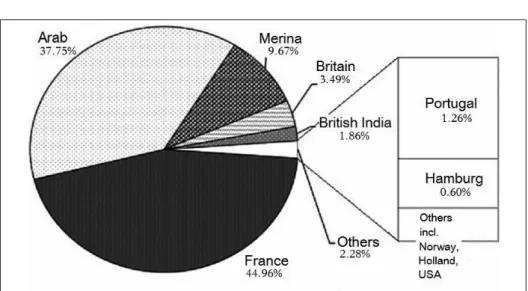
These ships included some that had come from Marseilles and also Swedish and Norwegian vessels, as well as American whalers. Simultaneously, what is remarkable is the fact that they also included many local vessels that plied between Nosy Be and the ports of Majunga and Maintirano on Madagascar’s west coast and ports in the western Indian Ocean such as Zanzibar and Bombay. An examination of the nationality of ships arriving in Nosy Be between 1843 and 1872 reveals that of the 2,154 ships recorded, approximately 37.75 percent are recorded as “Arab ships,” while Merina ships, which came mainly from the main island of Madagascar, accounted for 9.67 percent (Fig. 4). Ships from British India accounted for only 1.86 percent, but ships from Kachchh, the home region of many of the Indian merchants who played a central role in the western Indian Ocean in the nineteenth century, are recorded as Arab ships. Other categories mentioned in the original records are French, British, and Portuguese ships. The French ships included French registered ships, such as those from Nosy Be and the island of Mahoré (Mayotte in the Comoro Islands), which had become a French protectorate at the same
Fig. 3. The Annual Numbers of Ships Arriving in Hell-Ville, Nosy Be, in 1843–72 (3,683 Ships in Total)Note that there are gaps in the data for 1844, 1849, 1850–52, 1854, 1855, 1865, 1867, 1870, and 1872, and the data for 1845 and 1862–64 are missing. (Source: CAOM FM/SG/MAD/290/716 & 717)
time as Nosy Be.
29)British ships, too, included ships from British India and nearby protectorates. Portuguese ships were largely limited to ships from Mozambique. If one takes all this into account, it is clear that Nosy Be’s becoming a French protectorate did not bring to the island commercial relationships only with those ports beyond the Cape of Good Hope. By becoming a French protectorate, commercial relationships were also forged with ports in the western Indian Ocean, in the island’s immediate vicinity, and on Madagascar’s west coast.
These various commercial ties did not exist separately in a multistratified fashion. For example, ships connecting Nosy Be with ports in the western Indian Ocean took from the island sugar, turtle shell, timbers, hides, and so on, while they brought in labour and cattle, as well as crops and cotton fabric in which the island was no longer self-sufficient as a result of its specialization in plantation cultivation. Some of these imported commodities were re- exported to surrounding regions. For instance, according to import and export statistics for 1854, 47.79 percent of Indian and Arabian cotton fabric was re- exported.
30)The names of places in the vicinity of Nosy Be and place-names such as Maintirano and Morombe can be confirmed among the re-export destinations (see Fig. 5). In this manner, ports near Nosy Be and along Madagascar’s west coast acquired from Nosy Be goods that had either been shipped from ports in the western Indian Ocean or had been brought by ships that had come around the Cape of Good Hope. At the same time they supplied Nosy Be with crops such as rice, as well as ebony and other timber resources and hides, which were re-exported via this island to ports in the western Indian Ocean and markets in Europe and America.
Furthermore, it is not possible to ascertain from the situation on Nosy Be
any sort of division of labour among the ships. In other words, it was not the
case that only European and American ships linked Nosy Be with ports on the
Cape of Good Hope route while only Arab ships and ships from British India
linked it with ports in the western Indian Ocean. For example, the final
destination of most of the ships departing from Europe and America was ports
such as Bombay, Aden, and Zanzibar. Therefore, when calling at these ports
on their outward voyage they would bring with them goods loaded at Nosy Be,
and on their return voyage they would bring goods to Nosy Be from these
ports. Further, although Arab ships, ships from British India, and Merina ships
almost never sailed around the Cape of Good Hope, they acted as carriers
when goods brought by European and American ships were re-exported and
also took on the role of bringing to the island goods sought by European and
American ships. Thus, seemingly different commercial ties were interconnected
Fig. 4. Nationalities of Ships Visiting Hell-Ville, Nosy Be, in 1843–72 (2,154 Ships in Total) (Source: CAOM FM/SG/MAD/290/716 & 717)
Fig. 5. Place-names Associated with Ships Visiting Hell-Ville
through their use of Nosy Be as a node. This state of affairs is in stark contrast to the situation on the island in the early nineteenth century when it was very hard to trace housing. Having stood outside the commercial networks of the western Indian Ocean, Nosy Be became a place for various commercial agents to meet and a node in several networks as a result of its becoming a French protectorate. Next chapter is going to focus on commercial relationships with ports in the western Indian Ocean.
5. Links with the Western Indian Ocean World
The letter quoted below conveys in more concrete terms the behaviour of people living in the western Indian Ocean world at the time. Among the letters sent by the British consulate on Zanzibar to Great Britain there is the following letter that was sent by a certain Nabeli ibn Nuveli [sic.] to Sheik Khamis b.
Oozman [sic.].
My friend, I beg to inform you, that troops of the great king have come to the Island of Noosbeh and have fixed themselves there.… My dear friend, I beg to acquaint you that if you choose to remain at Noosbeh, it will be if it pleases God, advantageous to you; for the French are in want of such individuals as possess every information regarding the state of affairs in these countries, and because you are well versed in this.
31)This letter was written on 10 March 1841, immediately after the declaration of French protection on Nosy Be. It can also be ascertained from other sources that Khalfān b. ‘Alī, a leading merchant in Majunga who acted as an agent for Western merchants, had moved the base of his operations to Nosy Be.
32)Judging from such examples, it is evident that people living in the western Indian Ocean world were quick to see the transformation of Nosy Be into a French protectorate as a good business opportunity and swiftly acted accordingly.
In order to ascertain this fact quantitatively, one can make use of three sets of data extracted from CAOM FM/SG/MAD/290/716 & 717. One is the places where ships arriving in Hell-Ville were fitted out (Fig. 6). Among the 1,148 ships for which information has been recorded, 46.78 percent were fitted out on Nosy Be, and many nearby place-names are also given as outfitting locations, but there are also ships that were fitted out in Zanzibar, Bombay, Masqat�, or Kachchh.
Next, the statistics for the provenance and destinations of ships arriving in
Hell-Ville are given in Figs. 7 and 8. As is shown in Fig. 7, many ships arrived
Fig. 6. Outfitting Locations of Ships Arriving in Hell-Ville, Nosy Be, in 1843–72 (1,148 Ships in Total)
(Source: CAOM FM/SG/MAD/290/716 & 717)
Fig. 7. Departure Ports of Ships Arriving in Hell-Ville, Nosy Be, in 1865–72 (1,148 Ships in Total)
(Source: CAOM FM/SG/MAD/290/716 & 717)
Fig. 8. Destinations of Ships Departing Hell-Ville, Nosy Be, in 1865–72 (1,337 Ships in Total)
(Source: CAOM FM/SG/MAD/290/716 & 717)
Fig. 9. Arrival timing of Ships in Hell-Ville, Nosy Be, in 1843–72, Quarterly (3,683 Ships in Total)
(Source: CAOM FM/SG/MAD/290/716 & 717)
from nearby ports, and Fig. 8 shows that about one in four ships (23.92 percent) calling at Nosy Be were next headed for Zanzibar or Mahoré. Such ships were, of course, not limited to Arab ships, Merina ships, and ships from British India, and they also included European and American ships that had come around the Cape of Good Hope. Thus, Nosy Be’s becoming a French protectorate and its subsequent development into a military, transport, and productive base served not only to connect Nosy Be with ports on nearby islands and along Madagascar’s west coast and with ports along the routes plied by European and American ships coming around the Cape of Good Hope, but also to connect the island with ports in the western Indian Ocean.
The arrival and departure of ships followed the rhythms of the western Indian Ocean world, where movement on land and at sea and also production activities interconnected in accordance with the seasonal monsoon winds.
33)Therefore, in ports on the coast of East Africa, for example, ships gathered and peaked in the second half of the northeast monsoon season (January to March) and departed after the winds changed to the southwest. A similar fact can be ascertained on Nosy Be, too. Fig. 9 shows at what times of the year ships arrived, and it can be seen that the number of arrivals increased as the northeast monsoon ended and the southwest monsoon winds began to blow in the second quarter, whereafter the number of arrivals gradually decreased until the fourth quarter, when the southwest monsoon winds abated. Whereas it can be confirmed that ships gathered in Zanzibar and in Barbara on the Horn of Africa from the start of the northeast monsoon, ships gathered later in Nosy Be, which lay in the southernmost region affected by the seasonal monsoon winds. This fact was observed by Professor Léon, who visited the island in the second half of the 1850s:
Before the coming of the monsoon from the south-west and at the end of the winter season, I saw great dhows arriving from Zanzibar, Aden, Muscat and often even from Bombay.… This was the period of great transactions and entertainments in dancing.
34)Western Indian Ocean connection with Nosy Be was not limited to seasonality. In response to the demand for food supplies that grew with the increasing plantation cultivation of sugar cane and so on, ships from ports in the western Indian Ocean brought crops and beef cattle, and when cholera broke out in the western Indian Ocean ports, it reached the island on several occasions, including 1858.
35)While Hell-Ville was the port where the French had their military base
and shipping was supervised, major business transactions have been taken place in another port Marodoka, east of Hell-Ville. This port had several names, and on a map drawn in the journal of William Schloder, a crewman on the La
Plata, a merchantman from Salem in North America that visited Nosy Be in1845, Marodoka is called Banasoon.
36)It was also known as Ambanourou, and some contemporary records refer to it as the “Arab town.”
37)It can also be gleaned from contemporary sources concerning Marodoka that Kiswahili was widely used.
38)When I visited Marodoka in January 2008, it had by and large lost its functions as a port, and all I saw in the early afternoon in the dried-up bay at low tide was an abandoned outrigger canoe and a rotting dhow lying on its side.
In addition to a mosque that is still used by the villagers, there survive in Marodoka, now a small village, a mosque of which only the foundations, the minbar, and parts of the walls remain, and the ruins of what seems to have been a former residential dwelling and countless graves are scattered across a slope to the northeast of the village. Some of the gravestones bear Arabic inscriptions, but they are in poor condition and quite difficult to decipher. As far as can be ascertained today, the ruins of the residential dwelling are three- storeyed, with mangrove rafters and walls made of coral blocks. These building materials have been widely used throughout the western Indian Ocean rim, particularly along the East African coast.
Also of great interest is the fact that there are several elderly people in Marodoka who even today speak Kiswahili. They understand their ancestors to have been slaves who were brought here from Mozambique and Kenya, and they have a good command of Kiswahili. In fact, the folktales collected here in 1981 by N.J. Gueunier were narrated in Kiswahili.
39)According to several older people still living in the village, there were more people living in the village twenty or thirty years ago, and Kiswahili was spoken on a daily basis. But they also said that because the generation to which their children and grandchildren belong dislikes speaking Kiswahili, they will be the last generation to speak it.
6. Conclusion
In order to critically reexamine the corruption theory regarding the
Indian Ocean world, this article examines how the island of Nosy Be became a
French protectorate and the process whereby it subsequently became a node in
commercial networks. In 1841 Nosy Be, which at the start of the nineteenth
century was virtually uninhabited, was made a French protectorate. In this
process one can detect a number of factors, not only the relationship between the French empire and Malagasy kingdoms, but also rivalry between Malagasy kingdoms as well as between European empires, and entangled political relationship among these players including the Āl Bū Sa‘īd dynasty who was trying to subjugate other dynasties along the coast of East Africa at that time.
Emergence of French protectorate on Nosy Be needs to be understood in this intermingling.
French protection brought several commercial networks to this island.
First, the network utilized by European and American ships connecting between the Indian and the Atlantic Oceans, and secondly one which has been created and maintained by Malagasy seafarers, and thirdly western Indian Ocean trading network. Merchants were carefully watching political progress over Nosy Be. Once protectorate emerged, they expanded their own networks, linked themselves to others.
If we take the above into account, it becomes difficult to accept the corruption theory regarding the Indian Ocean world. But nor is it correct to assume that the Indian Ocean world continued to exist without undergoing any changes whatsoever. The way in which a new node arose and activated alerts us to the elasticity, flexibility, and mutability of commercial networks, such that commercial networks of different origins are able to readily intermingle and grow. If we focus on this character of commercial networks, and if the Indian Ocean world was founded on commercial networks, then it will not suffice to focus only on the geographically delimited Indian Ocean when discussing the corruption theory. Rather, the arguments put forward in the above will need to be further developed in the direction of world history, freed from such geographical constraints.
Notes 1) On the corruption theory, see Suzuki 2017: 8–10.
2) Pearson 2003; Alpers 2013.
3) Bertz 2008: 28.
4) Bose 2002: 376.
5) See, e.g., Suzuki 2016; Suzuki 2017.
6) Decary 1960 deals with the island’s colonization by France, while Monnier 2006 focuses on sugar plantations, which were until recently the island’s most important industry, and discusses the contract labourer system that was introduced after the abolition of slavery in 1848.
7) Jehenne 1893: 6.
8) Dewar and Wright 1993: 434–435.
9) Hunt 1650. “Assada Bay” here indicates the Bay of Ampasindava according to the
map in Charles Wyldes’ logbook (BL Sloane MS 3231, f. 11r).
10) Jenson 1973: 31, 44, 46.
11) Jenson 1973: 46.
12) Jenson 1973: 21–22n5.
13) Boteler 1835, 2: 169.
14) Boteler 1835, 2: 169.
15) Jehenne 1893: 10.
16) Slaves were freed on Réunion in 1848, whereafter a system of contract labour was introduced, with many Chinese and Indian workers being brought to the island (Wong-Hee-Kam 1996; Ho 2004: 69–100). But it is also widely known that for a time even after the emancipation of slaves a certain amount of labour continued to be supplied from the coast of East Africa, Portuguese Mozambique, and Madagascar.
Between 1848 and 1859, for example, on average 7,500 indentured labourers were brought in annually from Madagascar and nearby islands (Campbell 2005: 215–216), while on average 3,089 African labourers arrived on the island annually (based on Ho 2004: 89–90, table 9).
17) CAOM FM/SG/MAD/286/702/n.p. (Traité de cession à la France des îles de Nossi-Bé et Nossi- Cumba par la Reine Tsouméka).
18) See, e.g., Brown 1995: 111–132; Deschamps 1965: 153–161.
19) On Tsiomeko’s flight, see Vérin 1986: 363–364.
20) NAUK FO54/4/60-61 (Of a treaty made by “Nheeko bin Bytuk” and “Boobah bin Funhanah” ambassadors for “Smeeko” Queen of the Sukalavas and His Highness Saeed Seyed bin Sultan—at Zanzibar 4th Shabani Suffer 1254. As we say we are the poor of god. Nhekoo bin Bytuk and Boobah bin Funhanah).
21) See, e.g., Brown 1978: 177; Sharp 2002: 45.
22) Reda Bhacker 1992: 54, 151–157.
23) Campbell 2005: 77–78.
24) In existing literatures, typified by Deschamps 1965: 153, 164–165, Radama I and Ranavalona I have been viewed as polar opposites, with the former being regarded as a pro-European and open-minded ruler, while the latter was a narrow-minded tyrant who closed Madagascar to the outside world through policies banning Christianity and so on. But since the 1970s this view has begun to be reconsidered, and it has come to be pointed out, as described above, that towards the end of his reign Radama I himself sought to curb the infiltration of Western influence on Madagascar.
Furthermore, the view that Ranavalona I’s reign was a continuation of this is now becoming established. See also Campbell 2005: 59–60.
25) Ade Ajayi 1989: 426; Brown 1995: 154–155.
26) Decary 1960; Monnier 2006.
27) Campbell 2005: 173.
28) Campbell 2005: 173–174.
29) On French registered ships, see Suzuki 2017: 167–187.
30) CAOM FM/SG/MAD/288/-/n.p. (Commandant particulier de Nossi-Bé to Ministre de la Marine et des Colonies, s.l., 17 avril 1855).
H. Hart, who visited Zanzibar in the 1830s, clearly states that cloth from Masqat�
was being used for turbans on Zanzibar (QWWT WS/H/1/43-44 [Hart to Gore, His Majesty’s Ship Imogene at sea, 10 February 1834]). It is to be surmised, however, that
the Arabian cotton fabric mentioned here consisted primarily of sewn articles produced in Masqat� and nearby Muttrah in Oman, such as cylindrical embroidered hats known as muṣar (Arabic) or kofia (Kiswahili) and cloak-like wraps worn by women and called ‘abā’ah (Arabic). It has been confirmed that a sewing industry had developed in Masqat� and Muttrah in the nineteenth century, and it has also been pointed out that already in the eighteenth century sewn articles were being exported to East Africa (Reda Bhacker 1992: 133–135). The raw cotton that was being processed in Oman was brought from Bandar-e ‘Abbās and Bandar-e Būshehr on the opposite coast of the Gulf of Oman and Persian Gulf or from ports in Kachchh in northwestern India (CAOM FM/SG/OIND/2/10(1)/n.p. [Documents sur le commerce extérieur, aôut 1845]).
31) NAUK FO54/4/64-65.
32) Bennett and Brooks 1965: 391 (William McFarland to Michael Shepard, Zanzibar, September 15, 1848), 417 (A visit to eastern Africa, 1849). On Khalfān b. ‘Alī, see Bennett and Brooks 1965: 391n111.
33) Suzuki 2010: 91–107; Suzuki 2013.
34) Quoted from Léon 1894 in Vérin 1986: 367.
35) See, e.g., Campbell 2005: 175–176; Lawson 1893: 88.
36) PPEM LOG1847W3/n.p. In addition, the place-name Banasoon is mentioned in Bennett and Brooks 1965: 419, 420, 424 (A visit to eastern Africa, 1849).
37) CAOM/FM/SG/MAD/240/530/n.p. (Commandant la division navale des côtes orientales d’Afrique to Etat général, 6 septembre 1873); Bennett and Brooks 1965: 419 (A visit to eastern Africa, 1849).
38) Bennett and Brooks 1965: 421, 423 (A visit to eastern Africa, 1849). For a detailed summary of information about Marodoka, see Vérin 1986: 364–370.
39) Gueunier 2004: 134–145.
Abbreviations BL British Library, London, U.K.
CAOM Centre des Archives d’Outre-Mer, Aix-en-Provence, France NAUK National Archives, Kew, U.K.
PPEM Philips Library, Peabody-Essex Museum, Salem, MA, U.S.A.
QWWT Qasm al-Wathā’iq, Wizāra al-Tarāth wa al-Thaqāfa, al-Khwayr, Salṭana al-‘Umān References
Ade Ajayi, J.F.
1989 Africa in the Nineteenth Century until 1880. Paris: United Nations Educational, Scientific and Cultural Organization.
Alpers, Edward A.
2013 The Indian Ocean in World History. Oxford: Oxford University Press.
Bennett, Norman R., and George E. Brooks (eds.)
1965 New England Merchants in Africa: A History through Documents 1802 to 1865. Boston:
Boston University Press.
Bertz, Ned
2008 “Indian Ocean World Travellers: Moving Models in Multi-Sited Research.” In Helen Basu (ed.), Journeys and Dwellings: Indian Ocean Themes in South Asia, 21–60.
Hyderabad: Orient Longman.
Bose, Sugata
2002 “Space and Time on the Indian Ocean Rim: Theory and History.” In Leila Tarazi Fawaz and Christopher A. Bayly (eds.), Modernity and Culture: From the Mediterranean to the Indian Ocean, with the collaboration of R. Ilbert, 365–388. New York: Columbia University Press.
Boteler, Thomas
1835 Narrative of a Voyage of Discovery to Africa and Arabia: Performed in His Majesty’s Ships Leven and Barracouta from 1821 to 1826, 2 vols. London: Richard Bentley.
Brown, Marvyn
1978 Madagascar Rediscovered: A History from Early Times to Independence. London: Damien Tunnacliffe.
1995 A History of Madagascar. Princeton: Markus Wiener.
Campbell, Gwyn
2005 An Economic History of Imperial Madagascar, 1750–1895: The Rise and Fall of an Island Empire. Cambridge: Cambridge University Press.
Decary, Raymond
1960 L’île Nosy Bé de Madagascar: Histoire d’une colonisation. Paris: Editions maritimes et d’outre-mer.
Deschamps, Hubert
1965 Histoire de Madagascar. Paris: Berger-Levrault (1st. ed., 1960).
Dewar, R.E., and H.T. Wright
1993 “The Culture History of Madagascar.” Journal of World Prehistory 7 (4): 417–466.
Gueunier, N.J.
2004 Contes de la côte ouest de Madagascar. Antananarivo and Paris: Ambozontany and Karthala.
Ho, Hai Quang
2004 Histoire économique de l’île de la Réunion (1849–1881): Engagisme, croissance et crise.
Paris and Saint-Denis: L’Harmattan and Université de la Réunion.
Hunt, Robert
1650 The Island of Assada, Neere Madagascar Impartially Defined; Being a Succint, Yet Plenary Description of the Situation, Fertility and People Therein Inhabiting, etc. London.
Jehenne, A.-C.
1893 Renseignements nautiques par Nossi-Bé, Nossi-Mitsiou, Bavatoubé, etc. etc. (côte N. O. de Madagascar). Paris: Imprimerie Royale.
Jenson, J.R. (ed.)
1973 Journal and Letter Book of Nicholas Buckeridge 1651–1654. Minneapolis: University of Minnesota Press.
Lawson, R.
1893 “On the Manifestation of Cholera in Ships at Sea, and Their Connections with Outbreaks on Land.” Transactions of the Epidemiological Society 11: 81–107.
Léon, Dr.
1894 “Nossi-Bé.” Bulletin de la société géographie commerciale de Bordeaux 13: 396–400; 14:
411–420.
Monnier, J.-E.
2006 Esclaves de la canne à sucre: Engagés et planteurs à Nossi-Bé, Madagascar 1850–1880.
Paris: L’Harmattan.
Owen, W.F.W.
1833 Narrative of Voyages to Explore the Shores of Africa, Arabia, and Madagascar; Performed in H. M. Ships Leven and Barracouta, under the Direction of Captain W. F. W. Owen, R. N.
by Command of the Lords Commissioners of the Admiralty, 2 vols. London: Richard Bentley.
Pearson, Michael N.
2003 The Indian Ocean. Oxford: Oxford University Press.
Reda Bhacker, Mohamed
1992 Trade and Empire in Muscat and Zanzibar: Roots of British Domination. London and New York: Routledge.
Sharp, L.S.
2002 The Sacrificed Generation: Youth, History, and the Colonized Mind in Madagascar.
Berkeley: University of California Press.
Suzuki, Hideaki 鈴木英明
2010 “19 seiki Indo-yō nishi-kaiiki sekai to ‘kindai’—dorei kōeki ni tazusawaru hitobito no hen’yō” 19世紀インド洋西海域世界と「近代」―奴隷交易に携わる人々 の変容. Ph.D diss., University of Tokyo.
2013 “Indo-yō nishi-kaiiki sekai no kanōsei—kaiiki-shi kara sekai-shi e” インド洋西海 域世界の可能性―海域史から世界史へ. Rekishigaku Kenkyū 歴史学研究 911:
178–185.
2016 “The ‘Banian’ in Port Town: A Case Study of the Kachchhi Bhatiya in Nineteenth- Century Zanzibar.” In Awet Tewelde Weldemichael, Anthony A. Lee, and Edward A. Alpers (eds.), Changing Horizons of African History, 149–172. Trenton:
Africa World Press.
2017 Slave Trade Profiteers in the Western Indian Ocean: Suppression and Resistance in the Nineteenth Century. New York: Palgrave.
Vérin, Pierre
1986 The History of Civilisation in North Madagascar. Rotterdam and Boston: A.A.
Balkema.
Wong-Hee-Kam, Edith
1996 La diaspora chinoise aux Mascareignes: Le cas de la Réunion. Paris and Saint-Denis:
L’Harmattan and Université de la Réunion.