The expansion of the Yarkand Oasis
著者(英) Sunao Hori
journal or
publication title
The Journal of Konan University. Faculty of Letters
volume 154
page range 37‑51
year 2008‑03‑15
URL http://doi.org/10.14990/00000914
The expansion of the Yarkand Oasis
Hori Sunao
Introduction
The Yarkand Oasis is located at the very edge of south-western Takla- Makan
(Taklimakan) Desert in southern Xinjiang ‒ Uyghur AutonomousRegion in the present China (People's Republic of China).
In this essay, it is attempted to present an outline of the expansion of the oasis (which means of the farming land
) and features of its changes fromthe 18
thcentury to the present age.
1 The expansion of cultivated area in the Yarkand Oasis
(1)
The outline of the present Yarkand Oasis
-A big oasis spreading over a few prefectures
Present Yarkand
(Yäkän in Uyghur) indicates(莎車) in Chinese.
It's because the place, the modern city Yäkän (Yarkand) and surrounded area, remains it as the prefecture name. However, historical meaning of Yar- kand as an oasis (or as a district) covers the broader area.
1)Therefore, to avoid misunderstandings in this essay, Yarkand is used as the big oasis or as the historical region in the broad sense. As the same reason, Yäkän , following the present Uyghur, is used as the city or the
1 For instance, in the Qing Dynasty, as an administrative district, (葉爾羌)covered the same area as two districts and nine prefectures in present days.
name of prefecture.
As a definition of physical geography, an oasis is considered as the place that keeps fresh water constantly in the dried land. Historically, the oasis also meant as an aggregation of the man-made arable land. Under these two conditions, the oasis surrounded the present Yäkän prefecture is a vast culti- vated area that covers four prefectures
(Yäkän, Poskam, Qaghiliq andMäkit). Moreover, at a desert between Yopurgha
(the north west) andMaralweshi (the north east), the farming land is expanding. Before too long, a huge farming land will appear in this area.
From the 1980s to the 1990s, the arable area in the Yarkand Oasis that covers 4 prefectures comprises about 3,000,000 .
(1=6.6a, 19,760ha)
(The total of Yäkän, Poskam, Qaghiliq and Mäkit, except mountainous dis-trict.) The number was summed up from each prefecture's record.
(2) The summary for the expansion of the Yarkand Oasis -From the mid 18th
century to the 20
thcentury
In the 1770s, the Qing Dynasty introduced the government system in this area. The Yarkand Oasis had about 590,000 of farming land. The calcula- tion is as follows. The total amount of 1/10 tax was 20,000 [石]. This num- ber is simply considered as the seeding amount. The local unit of this was about 4,000 . From a governmentally-owned land, 900 was sup- plied. Thus, 4,900 is considered as the farming land. 1 seeding area = 120 . (This is recorded in .) Therefore, 120
×4,900 =590.000 .
In the 1840s, the reexamination of taxable arable land was enforced. The
result was recorded in so-called , the tax collection record of
Yarkand written in 1855/56. The document is the possession of Tokyo Uni-
versity Orient Culture Institute. The arable area recorded in the document
was about 12,200 . Following 1 120 which written in the
same document, the land covers equals about 1,460,000 . (The ground is
followed the present Yarkand Oasis as showed in the previous section.) During the end of the Qing Dynasty, in about 1910, the detail of farming land in the Yarkand Oasis can be found in
「新疆図志」(
(溝渠志)). The numerical value was written in each irrigation canal. Applyingthe same standard as above, the total of the land would be about 1,680,000
.
The oasis has been spreading.
(During the1980s and the 90s, there was about 3,000,000 as mentioned above.) However, these documents were written for different aims, besides the conversion rate is mistrustful. More- over, the data was from the government side. Therefore, we can only find the fact that the farming land has been expanding for more than 200 years.
2 Changes of cultivated area in Yäkän prefercture - from the 1850 s to the 1990 s.
(1) Yäkän prefecture ‒ as a part of the Yarkand Oasis
The expansion of farming area in the Yarkand Oasis after the conquest of the Qing Dynasty is as follows. (The figure is very rough though.)
It is of importance to focus on the period and the place if we discuss the detail.
The reason is as follows. , 1855/56 was the oldest docu- ments that used yaza(郷) and känt (村) for counting the farming villages in the oasis. Only one document that can contrast with is
⌒
2)
(for short,
), writ-ten in Uyghur in the 1990s, using the same counting unit. Unfortunately, the
The late 18th century About 590,000 (The part of Yäkän prefecture) 1855/56 About 1,460,000 About 830,000
About 1910 About 1,680,000 About 1,000,000
1990s About 3,000,000 About 1,800,000
2 ⌒ Yäkän, 1996 (?).
other prefectures (Poskam, Qaghiliq and Mäkit) composing the Yarkand Oa- sis are not able to use the present detailed information. Besides , in the early 20
thcentury, the data was classified in each waterway. Those names of wa- terways coincided with village names in and in nearly perfectly.
3)However the location was vague, thus it is unreliable in some parts.
4)The change of farming area that we can focus on is in Yäkän prefecture.
The period is after 1850s. It is needed to use village data in and its of written in present days as the base. Also the data of
is needed for some support.
(2) The scale of irrigation in present Yäkän Prefecture
It is well known that in Yäkän prefecture, people can not maintain farming without man-made irrigation system. A recent annual precipitation is only
45.3mm in average. ( p.105)
Therefore if it is possible to obtain the detail of irrigation canal, we can clarify the approximate distribution of arable land. In this point of view, a useful document is a topographical map 1/100,000 issued in the USSR in the 1980s, which is now the possession of Gifu prefecture library.
Attached MapⅠ is an outline of irrigation canal in Yäkän prefecture in the 1970s. The data is based on the topographical map above-mentioned. It is mixture of natural river, traditional canals and canals based on the recent project after the new China was established. Therefore it is similar to the thing we can observe at the spot today. The big difference between historical irrigation canals and that of present days is the existence of long drainage,
3 The comparison is in [Hori 2004].
4 We do not have the exact information for the location of känt in . However, in this case, it is clear that the waterway belonged to Yaza, therefore the comparison between place names in and that of present days was easily proceeded .
salt elimination system and large scale of dams (for water saving). The numbers of them are increasing in present days.
(3) Distribution of farming villages ‒A comparison of the days of
and the present days
The map made in the USSR is based on satellite photographs; therefore the data of place name is insufficient. Concerning to the place name, is more reliable. MapⅡ (the present villages in Yäkän prefecture and villages
(小 荘) in.) In this
MapⅡ, village names are distinguishednames coincided with names in (showed as ●), from names which were not in the document (showed as ◎).
Many villages close to Yäkän city can be found in . On the other hand, as being far away from Yäkän city, the percentage of coincidence tends to be lower.
We paid attention to this phenomenon, and put present yaza (郷)・bazar
(鎮) that were not onupon an outline of canals on the Map
Ⅲ
.
(Larger subordinate villages (総 荘) on and villages of present Yäkän prefecture)
Present villages enclosed like Khan⌒gdi in the map can not be seen in . It is considered that in the mid-19
thcentury, there was no känt in that area, which means the area was not farmed at all. These 7 yaza ・bazars are all located in the east and the north of Yäkän prefecture. This place is the lowest place in the Yarkand Oasis and is the lower reaches of the river.
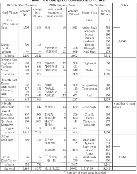
3 Features of expansion of the cultivated area in each district in Yäkän prefecture
(1) The outline of changes of cultivated area
It is needed to clarify the spatial detail about the expansion of arable land
5 We need to except Qoshrap (霍什拉甫) District that has 3 yazas. (The South- ↗and arrangement of irrigation system in Yäkän. In the attached
Table, thedata of 3 periods is divided into areas covering waterways and brooks.
(Changes of arable land in Yäkän in the 19th
century to the 20
thcentury.)
5)The arable land in villages of the prefecture was divided into 6 regions.
The source is alone the Yarkand River.
6)In the main waterways(östän
⌒g)
laid on the Yarkand River, regions depend on the Opa Östän
⌒g, the biggest and the oldest, are ① from to ③, and the rest, ④ to ⑥ rely on different irrigation canals.
Let us consider the changes of arable area in Yäkän using this Table.
(2)
Features of each district
a. Irrigation canals centering around the Opa Östän⌒
g
Neighboring villages of Yäkän city are located in the North-West, the North-East and the South-East part of the oasis. With a few exception, most parts rely on the Opa Östän
⌒g. Exceptional two yaza ・bazars are located at the edge of the North-West part. They rely on new water ways constructed after the issue of . The Han⌒gdi Östän⌒g (= 荒地渠, 旧劉渠, Yen⌒gi-abat Östän⌒g(英額瓦提渠)) was set in 1887
7), being recorded in
. The Shin⌒gnuch (= 新劉渠) was set in 1915, which was not recorded in .
① The North-
West of Yäkän Oasis
In this area, the farming land relied on the Opa Östän
⌒g was expanded from
↘West of Yäkän Prefecture) The reason is the District is separated with the desert from the Yäkän Oasis that we are concerning in this essay, although Qoshrap was recorded in as the big villages in Yarkand.
6 Baghwat Yaza and Qarasu Yaza are new villages in the 20th century. The water is taken from the Tiznap River.
7 It is clear that 4 waterways of upper and mid Yen⌒gi-abat Östän⌒g(英額瓦提渠)
(reaches around Rawatchi(熱瓦奇荘)in ) and a waterway of lower part (Teräk-län⌒ggär) were already constructed in the 1850s. Therfore, this östän⌒g was not the brand-new of the construction in 1887. (cf. Hori 2005, pp.179-181)
180,000 in 1855/56 to 190,000 in the end of the 20
thcentury. The ex- pansion was small, however, as the remarkable point , the land was expanded northward widely.
In in the 19
thcentury, northern end of arable land and gov- erned area were Elishqu (愛吉特虎) and Teräk-län
⌒ggär (鉄列亮喝爾). Both of them are now in Elishqu Bazar.
Khan
⌒gdi Bazar and Dön
⌒g-bagh Yaza are located in further north. They ware reclaimed in the end of the 19
thcentury, and also in the beginning of the 20
thcentury.
The length of Opa Östän
⌒g was originally 96 km. After the repair by the New China, it became 65km. Be that as it may, it is still big östän
⌒g. However, the use of canal has limitation except near the sluice gate of the Yarkand River, which is for the irrigation in a part of Arslan-bagh Yaza. The use has not been made as far as the middle of the canal. The reason was unclear since we could not have used a map of reference with contour lines. Fortu- nately, after making an on-the-spot inspection, we found out the upper part of canal was not man-made; moreover, about 20 km far from near the head gate, the river was running through under the deep cliffs that were more than 10m away from the shore. (I've got an idea if [Yar-kand] means [Cliff-Town], the name must have derived from this sight.)
The point where the surface of Opa Östän
⌒g reaches the same height as the shore is from the middle reaches; Concretely, after the crossing point of Kashghar-Khötan highway in Gül-baghYaza.
It is certain that the direct water intake from this östäng increases from this point.
② The North-East of Yäkän Oasis
The farming land decreases in this area. After the issue of ,
about 20,000 of the land was reduced. Even from the beginning of the 20
thcentury, it has been reduced about 30,000 . The reason is not clear. As a
few possibilities, since Yar-Bagh big villages were dismantled, the territory was obscure; the stream of the Yarkand River changed; and the big dam was constructed. It might have been because of mere statistical mistakes, but it must be suggested the reduction of existing farming land would happen.
Villages in this district are irrigated with present Misha Östän
⌒g from Opa Östän
⌒g and about 15 branches separated directly from the Opa. Regrettably, the Misha is recorded as Aq-ata ariq ( 阿哈阿塔渠) in . There- fore, the location and branches have some obscure points.
Furthermore, although eastern part of villages in this district expands to- wards the left bank (west) of the river, most of arable lands on the coast are a few meters higher than the river surface or river embankments were con- structed; Therefore the water intake has not been carried out.
③ The South-East of Yäkän Oasis
It is the village neighboring the south-east of Yäkän city. The altitudinal variation is big in the area and slopes eastward, toward the Yarkand River.
The farming land in this area has increase about 30 % for 150 years. Howev- er, ② and ④, southern and northern part of borders are obscure. With this point, we can consider the increase was in very small quantity.
At any rate, it is the farming area that spreads from the Jilchaq Östän
⌒g
(branch off from the Opa Östän⌒g running through to the North- East) to the drainage point of the Yarkand River.
It is noteworthy that the Jilchaq has been maintained the best for keeping the original condition among the oases. This is because the winding damp area prevented from new construction. It is understandable that in the 18
thcentury, the expedition of Qing Dynasty had a desperate fight at the Qara-su war at this place owing to the terrible geographical features.
b. Irrigation canals centering around the Chiliq Östän⌒
g
④ The South of Yäkän Oasis
The Chiliq Östäng has the head gate and the drainage point in the Yar- kand river. The area is depending on this canal. The farming area has been decreasing about 20 % from the beginning of 20
thcentury. It is because the Yarkand River changed its waterway and riparian works were carried out.
This district is the best for its well-planned and straight lined waterway repair in the oasis.
c. Irrigation canals centering around the Charäk Östän⌒
g
⑤ The West of Yäkän OasisThe farming area is located in the west end of Yarkand oasis. This area is depending on 2 östän
⌒gs. One is the Korwat, running through as the border of the desert and the oasis. The other is the Charäk, running parallel to 5 km east of the Korwat. Both of them vanish their tails in the desert. It is peculiar that about 60,000 mu of farming land was decreased from the 19
thcentury to the 20
thcentury.
The reason is clear. After the Muslim rebellion of north-western China, Qurghan village (98,000
) was abandoned. This village was cultivated un-der the leadership of the government in the end of the 1840s. Considering without this big village, the farming area was slightly increased as an exam- ple of the expansion in the north-west of Korwat district.
As mentioned above, the Han
⌒gdi Östän
⌒g and the Shin
⌒gnuchi Östän
⌒g that used the expansion of the district ① are running through the east of the Charäk Östän
⌒g, however, irrigation system of aforementioned canals had al- ready constructed in the 1850s.
d. Irrigation canals centering around the Bäsh-Känt Östän⌒
g
⑥ The East of Yäkän Oasis(
The East coast of the Yarkand river
・The Tiznaf river system)-In present villages in Yäkän prefecture, only three (Bäsh-Känt牌斯鉛, Tar-
tar塔塔爾, Kona-Tartar柯納塔塔爾-(Old Tartar)) existed in the east (right side) of Yarkand River at the times of . We found out Bäsh- Känt is present Besh-känt and Igärchi. However, we still can not have an idea which present villages suit both new and old Tartar. Even though, from the name of small village in TartarYaza, the big village was in the area of pres- ent Qara-su Yaza.
8)At any rate, although only about 80,000 land was recorded in the east cost of the Yarkand river in the 1850s, it increased in 250,000 in the early 20
thcentury. And now, the area spreads to the east cost of Tiznaf River, and covers the north-east of Yarkand Oasis, with 310,000 farming area in 7 yaza
・bazars.In other words, this district has the highest increasing rate of farming area in the Yäkän Oasis. The development was the result of the construction of Yen
⌒gstän (Awat as we know it today) Östän
⌒g in the end of the 19
thcentury and new drainages and reservoirs after the establishment of the autonomous region. The increased farming area was 170,000 in 4 yazas located at the lower reaches of the Bäsh-Känt. Moreover, the total of its increase in Qara-su yaza reached 210,000 .
The reason of the delay of the development in this area was a damp ground, and the area had been left for discharge water spot in case of a flood.
( It is not for the reason I mentioned before. Compare with the area near the Yarkand River and the Tiznaf River, this area is located in high position.) The cultivation has become possible owing to the present civil engineering.
4 Geographical features of expansion of cultivated area in Yäkän prefecture
In the end, let us make clear the features of changes of the farming land in Yäkän.
8 Hori 2005, pp.183-84
a. Near Yäkän city, and the south and the east region, the change of farm- ing area is small. (From the outline of districts ②③④.)
b. Arable land has expanded to the west and the north-west of the lower reaches in the desert owing to the construction of long distance canals.
(From the outline of districts ①⑤.)
c. At the damp ground in the east of lower part in the oasis, the land was expanded by the construction of new canals and drainages. As a result, it made a area that covers the Yarkand and the Tiznaf Rivers. (From the outline of district ⑥.)
Conclusion
Even it is very rough verification, we have clarified that in the North-West and the North-East of the lower reaches, the expansion of farming land is ob- vious in Yäkän prefecture for more than 150 years of changes of farming land in the Yäkän Oasis.
After this inspection, it is needed to make a precise conclusion of the above based on a detailed contour map. It is also needed to find out whether this tendency is the common phenomenon or not, for oases in the Central Asia at the same period, in other words, whether there is the possibility of general- ization can be proved or not.
< References ─All in Japanese─>
Hori S. 1980, The irrigation systems in under the Qing rule, ' , 14. pp.72-99.
Hori S. 1994, The cultivated acreage in under the Qing rule,
( ), 90. pp.16-35.
Hori S. 2004, The boundary of under the Qing rule,
( ), 134.pp.93-122.
Hori A. 2005, The villages and water canals of Yarkand under the Qing rule,
( ),139. pp.153-191.
Table The Changes of cultivated land in Yäkän
1855/56 1910s 1990s Notes
Head Village acreage(p.) change
into 100
main canal (number of small canals)
acreage
(100 ) Bazar・Yaza acreage
(100 )
City ─ ─ ─ ─ Yäkän 17
①North-West Opur
Elshqu Teräk -län⌒ggär
l,505
596
─ 1,806
715
─
窩浦 45
*愛吉特虎 2 英額瓦提 23
1,523
420 959
Arslan-bagh Gül-bagh
Ishqur Päkichi Qosh-eriq
Elshqu Khan⌒gdi Dön⌒g-bagh
553 228 496 379 250 530 600 278
──┐
│
│ │
─(1,906)
subtotal 2,101 2,521 2,902 3,314
②North-East Tagharchi Yar-bagh Mishar
209 569 224
251 683 269
*枯洪奇 12
*阿哈阿塔 11
*阿哈阿塔 26 368 451 510
Tagharchi Misha
650 376
subtotal l,002 1,202 1,329 1,026
③South-East Kamra Orda-östäng Khan-eriq Aral
252 127 92 374
302 152 110 449
*曲龍 8
*稀尼巴 4
*罕那里克 4
*沙巴拉 13 339 125 182 651
Yengi-östäng Tom-östäng
Aral
388 485 456
subtotal 845 1,014 1,297 1,329
④South
Otan-chiliq 539 647 秋魯克+ 13 632 Char-bagh 481
+another 4 main canals
⑤West Rawatchi Qosh-abad Qurghan Kökrawat- länggär
807 120 800 14
968 144 (980) 17
茄列克 3 英額瓦提 9 排泣普 科料熱 瓦特 6
266 623 141 434
Charäk Odanliq Zäräpshat Yaqa-eriq
605 780 277 196
subtotal 1,741 2,109 1,464 1,858
⑥East Besh-känt
Tartar Könä-Tartar
596
56
─ 715
67
─
別什幹 5 抜有力ロ 英額斯塘 15
** 吟拉蘇 2
塔 他 1,094
87 1,023 24 239
Bäsh-känt Igärchi Bagh-awat
AlmatAwat Azat-bagh
Qara-su
571 514 365 457 484 400 350
──┐
│
│
─(1,706)
subtotal 652 782 2,467 3,141
the total 6,880 8,275 M.-13/S.-202 10,091 B.-7/Y.-19 18,045
*
**number of main canal included belonging to Qaghaliq at the time