Key
Management of Wetland Ecosystems and Water Resources in the Lower Songkram River Basin, Northeast-Thailand
Kohei Kamata*, Samang Homchuen ** and Yasushi Sasaki *
The Lower Songkram River Basin (LSRB) encompasses a broad range of wetland habitats associated with the functional floodplain ecosystem that link to the Mekong Basin. Due to various habitat types, the Basin contains valuable natural resources. Communities located along the Songkram floodplain exhibit a high degree of dependency on wetland resources for their livelihoods such as capture fisheries, fish processing, harvesting wetland products, agriculture and livestock grazing. Thailand’s economic development during the past decade results in changes of local livelihood and greater complexity. Fish captured as a means to barter for essential goods has changed to fishery for cash income.
Conflicts are occurring between small and large scale fishers. Wetland ecosystems in the LSRB are gradually converted to farmlands such as eucalyptus plantation and tomato field. The wetland ecosystems are also deteriorating from human activities, especially big dams on upper Mekong Basin and weirs as well as from the impact of climate change. The studies conducted during 2004-2006 on wetland ecology, biodiversity and resource utilization in the LSRB indicate that impacts to wetland ecosystems and community structures are well-recognized but practical and economical wetland ecosystem management at local and regional scales remains limited. Due to early water level decrease in dry season, construction of check dams in sub-tributaries is recommended to balance water levels and extend flooding periods.
words: wetland ecosystems,Lower Songkram River Basin, water balance
1. Introduction
The 420 kilometers long Songkram River has catchments about 12,700 square kilometers within the provinces of Udorn Thani, Nong Kai, Sakhon Nakon and Nakon Panom. It is only one major Mekong tributary without a large dam. The whole basin is divided into upper and lower basin due to the different of geographical features .In the lower reaches, stretching up
to 200 kilometers from the mouth of the river, there is a seasonally flooded forest where annual floods cover an area of approximately 500,000-600,000 Rai for three or four months during the rainy season. The LSRB received floods derived from upstream runoff and backflow from the Mekong River. These ecosystems support a wealth of biodiversity and natural resources, subject to dramatic seasonal changes of floods and recession.
The complexity of local livelihood that have adapted to these environments is easily overlooked.
Rural livelihoods are based on the combined use of a wide range of resources adapted to seasonal changes.
Communities located along the Songkram floodplain exhibit a high degree of dependency on wetland resources for their livelihoods. Importantly, for the last three years unusual water fluctuation has been observed.
Such unusual water fluctuation has only ever been
* Graduate School of Science and Engineering, Saitama University, Saitama 338-8570
** Department of Environmental Science, Faculty of Science, Khon Kaen University, Khon Kaen 40002 Receive: 2007, April 14
observed within the last three years but the changes are already obviously recognized for instance the water level of the river is decreased earlier in dry season. While the exact causes may be in some doubt, such unusual water fluctuations are consistent with the development and operation of dams in the upper Mekong basin. When the river ecosystem is affected by the unusual water fluctuations, migration pattern of fish may also be affected as well as the degradation of seasonal flooded forest. Can wetland ecosystems in the LSRB be saved and how. People have to think about it before it can not be restored. This research is conducted to observe and collect data in order to make suggestions with regards to wetland use and water management.
2. Methodology
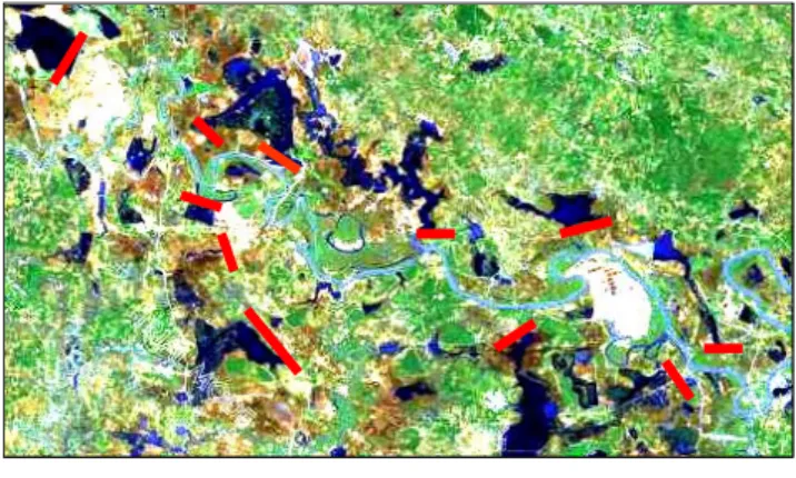
The field survey based study is carried out during 2004-2006 on wetland ecology, biodiversity and resources utilization in 10 villages by field observation, interview together with satellite images analysis and GIS applications in the LSRB (Fig 1).
Fig. 1 The study area of Songkram river basin
3. Ecology of the Lower Songkram river basin
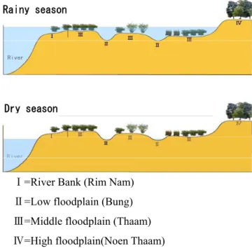
Part of the unique nature of the LSRB is the seasonally flooded forest (known in Thai as Pa Bung Pa Thaam) comprising many trees and shrubs, including a dominant pioneer bamboo species called Pai Gasa in the flood area and on the river banks. The vegetation related to landform
can be divided into four areas (Fig. 2 & 3):
Zone I : River bank (Rim Nam); this area is covered with the seasonally flooded forest which
Bambosa arundinacea is a dominant species.
Zone II : Low floodplain (Bung); this area is still have water in dry season no trees only aquatic plants.
Zone III : Middle floodplain (Thaam); this area cover with floods for 3-4 months in the rainy season, dominant species is also Bambusa arundinacea.
Zone IV : High Floodplain (Noen Thaam) this area cover with the dry-evergreen forest which.
Dry season (April 2006) Rainy season (Sep 2005)
Landscape of wetlands
Songkram river
Fig. 2 Landscape of wetlands in the lower Songkram basin in rainy season and dry season
Rainy season
Dry season
Ⅰ=River Bank (Rim Nam)
Ⅱ=Low floodplain (Bung)
Ⅲ=Middle floodplain (Thaam)
Ⅳ=High floodplain(Noen Thaam)
Fig. 3 Landforms and vegetations due to the fluctuation of water in the lower Songkram river basin
The village researchers find that the complex wetland ecosystems of the Lower Songkram River Basin consist of 28 different habitats, hosting diverse plants and aquatic organisms. These include 208 kinds of plants and fungi, 124 fish species, 5 turtle species, 4shrimp species, 10 mollusk species 4 crab species and 6 aquatic insects (Thai Ban Reserch, 2005).
0 2 4 6 8 10 12 14
1996 1997 1998 1999 2000 2001 2002 2003 2004 2005 2006
year m Maximum water level Minimum water level
Fig. 5 The fluctuation of water level in the Mekong river within 10 years (River levels typically vary 10-12 meters height difference between dry and wet seasons) at Nakhon Phanom station.
4. Water Level and Fluctuation
The LSRB encompasses a broad range of wetland habitats associated with the functional floodplain ecosystem that link to the Mekong Basin. The fluctuation of water level in the Mekong River will effect to the wetland ecosystem in Songkram Basin, especially in the year 2004 it was notable that rainy season finished abruptly in mid September at least a month ahead of normal and water level only at 0.42 m high in dry season while the precipitation is not different from another year.
This caused water levels to fall rapidly in the Songkram River and the floodplain (Fig. 4 &5). Such unusual water fluctuations are consistent with the development and operation of dams in the upper Mekong Basin.
5. Resources Utilization
The rural population of the LSRB are largely dependent on natural resources for their livelihoods.
According to the interview of local people in eight villages located next to the Songkram River, major incomes and subsistence of them are from fisheries (Fig. 6). Depending on seasonal and hydrological conditions, fishing tends to be highly seasonal activity, peaking during periods of fish migrations, both up and down the stream (Mekong →Songkram →Floodplain→
Songkram→Mekong). The most productive fishery comes at the end of rainy season (September-October).
Besides fish, many other types of living aquatic organisms are also harvested from the wetlands. These include mollusk, shrimp, crab, turtle, frog, snake, bird, and insect.
Dry season Rainy season
Water level of Songkram
H.W.L L.W.L
Mekong river
Migrant Only fishery
Fishery and gathering bamboo
Dry season
Fishery and rice farming Only rice farming
Rainy season
13%
17%
17%
87% 66%
Fig. 6 Major incomes of local people in the LSRB from products of wetland ecosystem
Fig. 4 Shown the fluctuation of water level in rainy season and dry season at Songkram river that linked
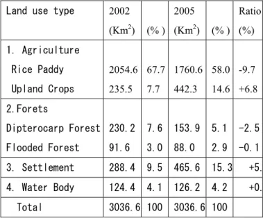
6. Conclusions and Discussion Landuse change was also studied by the application of
satellite images (Landsat 5 scale 1:50000 year 2002 and 2005) and GIS. The results found that there are 4 main types of land use such as agriculture, forest, water body, and settlement (Fig. 7)
While there is no doubt that the LSRB is a significant wetland area, the nature of and the change in the wetlands composition in recent years are not appreciated. There is strong evidence to show that there has been a very rapid conversion of forested land and natural wetlands being replaced by agriculture , upland crop: sugar cane, cassava, rubber tree plantation and permanent lacustrine wetlands (reservoirs).
The data shown in Table 1 was taken from analysis of satellite images (Landsat 5) in the year 2002 and 2004. While the increase in water resource appears, there has not been a corresponding increase in the paddy land as a result of more irrigation sources available. But at the same time, only some irrigated crops such as tomatoes and sweet corns which are belonged to several large agribusiness companies are arisen .
Rice Paddy Upland Crops Seasonally Flooded Forest Dry Dipterocarp Forest Water Body Settlement
The main agricultural crop grown in the area is wet paddy rice with smaller areas of cash crops (e.g.
sugar cane, cassava, tomato, melon and maize) Most farming in this region is characterized by rain fed agriculture with relatively small area being used for irrigated agriculture in dry seasons. From the study (Fig. 6) a large part of the local economy is likely to be derived from wetland products, especially fish both in the rainy and dry seasons. Because in the dry season the wetland can not keep much water, therefore fishery is not the main source of their incomes.
Fig. 7 Land use in the year 2002 (upper) and 2005 (under) by Landsat5, 1:50000
Table 1 Percent of land use changed from the year 2002 to 2005 (by Landsat 5, 1:50000)
Land use type 2002
(Km2) (% ) 2005 (Km2) (% )
Ratio (%) 1. Agriculture
Rice Paddy Upland Crops
2054.6 235.5
67.7 7.7
1760.6 442.3
58.0 14.6
-9.7 +6.8 2.Forets
Dipterocarp Forest Flooded Forest
230.2 91.6
7.6 3.0
153.9 88.0
5.1 2.9
-2.5 -0.1 3. Settlement 288.4 9.5 465.6 15.3 +5.
4. Water Body 124.4 4.1 126.2 4.2 +0.
Total 3036.6 100 3036.6 100
Villagers exhibit a high rate of out-migration for labor both in the nearby big cities and in Bangkok or abroad.
To prevent people migrate out from the villages, we must find the method in keeping enough water on floodplain during the whole dry season in order that they can do their fisheries. One of the above methods is to change a floodplain into a shallow reservoir by constructing a gate
Hd
water supply system for wetland extension groundwater river water wetlands
can not control can control
water supply system for wetland extension groundwater river water wetlands
can not control can control groundwater river water wetlands
can not control can control
Fig. 8 Water management model of constructing gates (sink dam) in keeping water on floodplain
Fig. 9 Diagram of the simulation of the water balance in wetland ecosystem
, sink dam as shown in the Fig. 8. References
The concept of this method is from the simulation of the water balance in wetland ecosystem as shown in Figure 9. Due to the water level decrease early in the dry season, construction of gates in sub-tributaries is strongly recommended before the wetland ecosystem is completely destroyed.
1) Baker, L., Thai Baan Research in lower Songkhram river basin, Thailand: reflections on experience and guidelines for establishing participatory resource research elsewhere. English summary eeport - Thai Baan Research, 2004.
2) Bennett, G., Integrating biodiversity conservation and sustainable use lessons learned from ecological networks. IUCN, 2004.
We assume that we can calculate the water level of wetland in dry season by the following equation.
3) Blake, D. and R. Pitakthepsombut., Situation analysis lower songkram river basin, Thailand.
Mekong wetland biodiversity conservation and sustainable use programme, 2006.
=Hr+W-E-P-O
Hd: Water level of wetland in dry season
(on the last day of August) 4) Sankamethawee, W., Case study on riverine floodplain forest (Paa Bung-Paa Thaam) along the songkhram river in Nakhon Phanom and Sakon Nakhon provinces funded by German Technical Co-operation (GTZ) on behalf of tropical ecology support program (TOEB), 1997.
Hr: Water level of wetland in rainy season
(on the last day of March) W: Total amount of rainfall from September to March E: Total amount of evaporation from September to March P: Total amount of permeability from September to March
O: Outflow of water from the wetlands to the river 5) Samang Homchuen, Yasushi Sasaki and Kohei Kamata, The Second International Field Ecology Symposium Biodiversity Management, Can wetland ecosystems in the Lower Songkram River Basin be saved? , 2007.