LIVING WITH DISASTERS:
LIVELIHOOD STRATEGIES IN CENTRAL VIETNAM
Akiko Iizuka
1∗, Ueru Tanaka
21
Utsunomiya University, Center for International Exchange, 350 Mine, Utsunmoiya-City,
Tochigi, 321-8505, Japan Address of first author
2
Research Institute of Humanity and Nature, Department of Research,
457-4 Motoyama, Kamigamo, Kita-ku, Kyoto, 603-8047
*Corresponding author:
iizuka@cc.utsunomiya-u.ac.jp AbstractDisasters are not new phenomenon in central Vietnam, where is located in the monsoon climatic zone. The rainy season lasts from September to January and the types of natural disasters include floods, typhoons, landslides, whirlwinds, and flash floods. Especially floods and typhoon between September and November have annually caused the damages, varying size although the local people have prepared and coped with these disasters based on their experiences and capacities. This paper analyzes the damages of disasters and people’s coping strategies at three sites: (1) Hong Ha, an upland, (2) Huong Van, a midland and and (3) Huong Phong, lowland areas of the Bo River watershed in central Vietnam. Although three sites were affected by the similar types of disasters, this study shows that the damages differ by three sites, depending on each geographical characteristics and production systems. Especially, physical and natural assets were heavily damaged in all three sites. In conclusion, this study highlights the importance of livelihood strategies to cope with natural disasters for sustainable livelihood of local people.
Keywords: disasters, floods, livelihood, disaster management, Vietnam
1. INTRODUCTION
Vietnam is a country of 83 million people. Over 70 per cent of its population is agrarian, with livelihoods based on agricultural cultivation and production, forestry and aquaculture. The central part of Vietnam is particularly at risk of disasters due to its location of monsoon climatic zone. The types of natural disasters include floods, typhoons, landslides, whirlwinds and flash floods. The local people annually suffer from such disasters during the rainy season from September to January although they have prepared and coped with the disasters based on their experiences and capacities.
The purpose of this paper is to study the impacts of disasters on livelihood and coping strategies at three different sites in Thua Thien Hue province. The central part of Vietnam possesses the diverse geographic characteristics within the narrow areas of 50 kilometers between South China Sea and the border with Laos. How are the impacts of disasters on the upland, midland and lowland areas of the Bo River watershed? Do the impacts vary among three sites with their different geographical, social and economic conditions? Furthermore, the people experience disasters every year and their coping strategies are identified in order to achieve sustainable livelihood in the disaster prone areas.
2. METHODOLOGY AND LITERATURE REVIEW
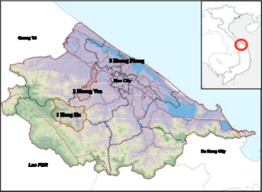
This paper analyzes the damages of disasters and people’s coping strategies in varied surroundings in upland, midland and lowland areas of the Bo River watershed in Thua Thien Hue province. As shown in Figure 1, the locations are (1) Hong Ha, an upland village, (2) Huong Van, a flood plain and (3) Huong Phong, a coastal village. The survey was conducted by the researchers of two universities: Hue University of Agriculture and Forestry (HUAF) and Graduate School of Global Environmental Studies, Kyoto University (GSGES)1. The field research was conducted by semi-structured interviews with key
informants including village leaders and union leaders and the affected people at three sites. The research was conducted during the rainy season in 2007, considering its severity of the damages and frequency of occurrence2. In fact, the floods occurred in 2007 were out of most people’s expectation:
six floods intensively caused the tremendous damages in central Vietnam during October 30 and November 18 just in less than one month.
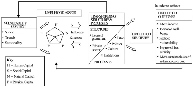
To analyze the impact of disasters on livelihood and its strategy, the concept of sustainable livelihoods framework is applied in this paper. The concept of sustainable livelihoods emerged in the 1990s and has been a main stream in the discussion of rural development paradigm last decades3. “The
sustainable livelihood framework summarizes the main components of and influence on livelihood”, including three components: vulnerability context (shock, trends, and seasonality), livelihood assets
1 Graduate School of Global Environmental Studies at Kyoto University (GSGES) has exchanged students and researchers with Hue University
of Agriculture and Forestry over ten years. I lived and worked in Hue for three years from 2006 to 2009 as a GSGES researcher.
2 The floods in 1999 is called as a historical flood causing tremendous damages in Central Vietnam province at the beginning of November
1999. More than 350 people died and more than 25,000 houses were fully or partially destroyed only in Thua Thien Hue province. The disasters in 2007 can be compared to the historical floods in 1999.
3 It has been adapted by many government and non-government organizations such as Department for International Development, UK
(DFID), United Nations Development Programme (UNDP) and CARE International.
Figure 1. Map of three sites in Thua Thien Hue province
(human, social, natural, physical and financial capital), and transforming structures and processes in order to achieve livelihood outcomes (see Figure 2) (DFID 1999). This analysis demonstrates the importance for inter-disciplinary or diversified sections in improving livelihoods. Livelihood resources include the different types of assets, some tangible and some intangible. Ashley and Carney introduces various capital assets as livelihood resources and group each capital accordingly (1999).
1) Human capital: knowledge, skills and good physical condition.
2) Natural capital: natural stocks such as water and soil and environmental functions. 3) Financial capital: savings and income.
4) Physical capital: infrastructure such as housing and roads.
5) Social capital; social and political network and relationship between local people.
The analysis of livelihood resources is used in the framework which elaborates sustainable livelihood outcome will be achieved by obtaining a “combination of livelihood resources” (Scoones 1998). According to Iwasaki; however, the framework has seldom been applied in the disaster management context due to its too broad concepts (2016). DFID states that “it does not provide the exhaustive list of the issue to be considered” as a limitation of the framework (1999). In this study; therefore, this framework is adapted and applied to the local circumstances in order to understand varied livelihoods influenced by disasters at three sites of central Vietnam.
3. RESULT AND DISCUSSION 3.1 Hong Ha
Overview
Hong Ha is a mountainous village in A Luoi district, located 45 kilometers to the south west of Hue city (see Figure 1. 1). The village is divided into five hamlets – Con Tom, Pa Hy, Can Som, Pa Rinh, and A Rom – which together provide a home to 1,332 people (Thua Thien Hue Statistical Office 2007: 58). People of Kinh ethnicity, who is the main ethnicity in Vietnam, number as few as 15 families, most of which are engaged in business sectors. Over 90 per cent of the population of Hong Ha belongs to one of four ethnic minority groups, namely Co-Tu, Ta-Oi, Pa-Hi, and Pa-Co. They still live in a subsistence economy although it’s been gradually changing. They have been adapting from their traditional shifting cultivation system to fixed cultivation and engaged in agricultural production of cassava, maize, rice and vegetables.
Disasters, the impacts on livelihood and strategies
Hong Ha often suffers from flood, typhoon, and landslide. The five floods and three typhoons occurred in 2007. The flood is often occurred along AA river. When AA river connects with Bo river in Pa Rinh hamlet, the flow of water slow down and often flooded (see Figure 3). The houses in Com Som hamlet and Pa Rinh hamlet in Hong Ha are often flooded since they are located along AA river and lower than the other hamlets. In 2007, no house in Hong Ha was flooded: the water came up to some gardens in front of houses, however the water level didn’t increase above the house foundation.
Figure 2. Sustainable livelihood framework (DFID 1999)
Influence & access Key H = Human Capital S = Social Capital N = Natural Capital P = Physical Capital F = Financial Capital LIVELIHOOD ASSETS LIVELIHOOD STRATEGIES TRANSFORMING STRUCTURES & PROCESSES VULNERABILITY CONTEXT STRUCTURES •Levels of government •Private sector •Laws •Policies •Culture •Institutions PROCESSES •Shock •Trends •Seasonality LIVELIHOOD OUTCOMES •More income •Increased well-being •Reduced vulnerability •Improved food security
•More sustainable use of natural resource base In order to achieve
The damages of natural and physical capitals were serious. The agricultural land was inundated by the constant and heavy rainfalls. The water with the soils and gravels drifted from the river or stream were deposited into the agricultural lands for cassava and rice. More than 20 per cent of cassava production areas were affected by flood in four hamlets of Pa Hy (5.5 hectors), Can Sam (5 hectors), Con Tom hamlets (4-5 hectors), and A Rom (3.6 hectors). Cassava root was spoiled due to the inundated water for long time or felled down with the power of strong water flow from the upper lands, characterized as flash floods. Right after the first flood, the people harvested cassava immediately to avoid the loss of cassava although cassava is normally harvested December to January next year (see Table 1); therefore, some harvested cassava roots were smaller than normal ones. Also, the deposited layer of soils and gravels were too thick to root out the cassava. As a result, the productivity of cassava was not as much as the usual. The natural capital was affected by flash floods and land inundation and their physical capital such as agricultural harvests was damaged. In this sense, natural and physical capitals are closely related in Hong Ha.
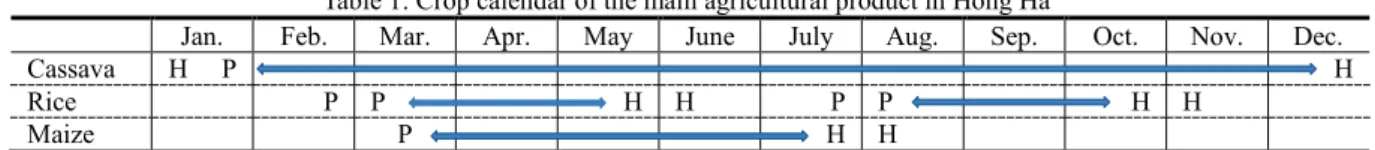
Table 1 shows the crop calendar of main agricultural products in Hong Ha: cassava, rice and maize. The people in four hamlets except Con Tam lost rice harvest. Rice is double cropping in a year harvesting around May to June and October to November. Early harvest of rice before the flood in Con Tam hamlet prevented the loss of rice harvest. Maize is one of the main agricultural products in Hong Ha and there is no damage to maize because it is harvested once a year in July and August before rainy seasons. The people have a strategies of right timing of the rice harvests before the floods according to the crop calendar.
Table 1. Crop calendar of the main agricultural product in Hong Ha
Jan. Feb. Mar. Apr. May June July Aug. Sep. Oct. Nov. Dec.
Cassava H P H
Rice P P H H P P H H
Maize P H H
Note: “P” stands for planting and “H” is harvesting. Rice is double cropping.
3.2 Huong Van
Overview
Huong Van is a plain village in the Huong Tra district, located 20 kilometers north west of Hue city (Figure 1. 2). There are 6,892 people living in the five hamlets of Lai Thanh, Long Khe, Son Cong, Lai Bang and Khe Trai (Thua Thien Hue Statistical Office 2007: 55). Most residents are of Kinh ethnicity, although a small portion of minority group of Van Kieu ethnicity lives in Khe Trai village. The people make a living by cultivating rice, vegetables, fruit and raising livestock such as pigs and chicken. Huong Van’s location renders it particularly prone to natural disaster: the village is severely affected by floods between September and December every year. Significant floods in 1999, 2004, 2007 and 2009 devastated housing, social infrastructure and livestock.
Disasters, the impacts on livelihood and strategies
The damages in 2007 was not as severe as the historical flood in 1999 since people gained coping strategies from the past experience. The continuous floods; however, caused damages to physical capital. Since Huong Van is located in Bo river basin, many houses in Huong Van were flooded in 2007. The water level and the damages are depending on the location. The most flooded area was Son Cong hamlet: 25% of houses in the hamlet was flooded because it’s lower than the other hamlets. Lai Thanh (15%) and Long Khe (10%) hamlets are following. The highest water level in Song Con hit 1.7 meters from sea level on November 15.
In the view of human capital, before the water level increases, many households evacuated to the other houses located in higher areas or built on the elevated foundation depending on their relatives or neighbors’ house. 16 households in Lai Bang and 11 households in Lai Thanh hamlet evacuated since their houses are located along Bo River. Some people live along the river for convenience in spite that the village provides the land at higher area to build the house. They only built the temporary houses in the higher land and stay during the flood and go back to live along the river after the flood due to the convenience. An officer of Huong Dien hydroelectricity lost his life: he was swallowed up by the river water flow while he went across the river to take tea leaves.
The flood caused severe damage to natural and physical capital. Cassava which is one of the main agricultural products in Huong Van was spoiled as large as 30 hectors and young pomelo trees, a type
of fruits which is famous in this area were spoiled in five hectors. There is no severe damage of livestock because the local people sell it or actively moved it up while the water level was going up. Regarding infrastructure as physical capital, the water pumping station along the river in Lai Bang, Son Cong, and Long Khe hamlets were filled up with water and didn’t work for a while. The school was closed for 15 days during the five floods at total. The secondary school is located at high area and was not flooded; however, the students could not go to school because two main roads were flooded.
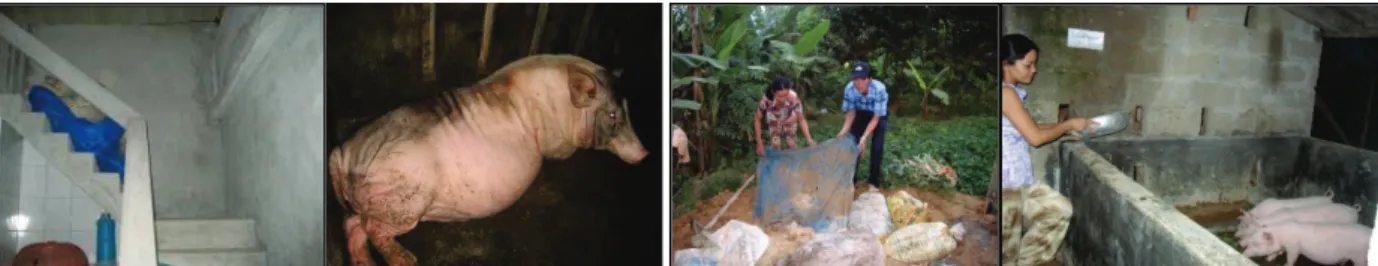
More than 70 per cent of households engages in rearing pigs in Huong Van village. Many households have boats to evacuate pigs during the floods, but the capacity of the boats is not enough; in fact, Ms Cau, a pig producer at low area in Huong Van, could evaluate only two to three pigs by a boat. The people have to sell pigs at lower price before rainy season because they are afraid of losing pigs by flood. Therefore, HUAF and GSGES project partly supported the cost of constructing a two-story pigpen which is used for evacuating pigs during floods4 (see Figure 3). After constructing two-story
pigpen in August 2008, people can keep raising pigs during rainy season, especially sow and sell them later at higher prices as a livelihood outcome. During dry season, some people use the space of two-story pig pen for storing feed or raising chicken.
Also, feed for pig is one of the important issues for pig farmers in Houng Van, especially in rainy season when local people have difficulty in cooking cassava as the feed. HUAF organized the training of producing fermented cassava as pig’s feed and conducted trials at key farmers’ house. The fermented cassava put in nylon bag can be kept under ground for seven to eight months without being affected by floods. Cassava is usually harvested in the rainy season in Huong Van, so local people can make use of local resource and ensure the feed for pigs during rainy season. Around 200 pig farmers in Huong Van use fermented cassava in the flood season in 2009 (see Figure 4).
3.3 Huong Phong
Overview
Huong Phong is a coastal village in Huong Tra district, 12 kilometres north of Hue city (see Figure 1. 3). There are 10,824 people living in the six hamlets of Thuan Phuoc, Thuan Hoa, Tien Thanh, Van Quat Thuong, Van Quat Dong and An Lai (Thua Thien Hue Statistical Office 2007: 56). The residents engage in aquaculture, fishing, rice production and animal husbandry. Livelihood depends on geographical location: many residents of Thuan Hoa and Van Quat Dong, located near Tam Giang lagoon, engage in aquaculture, whereas the inhabitants of other hamlets are more typically engaged in rice cultivation and animal husbandry.
Disasters, the impacts on livelihood and strategies
Huong Phong is located at the end of Huong river and Bo river and along Tam Giang lagoon, making vulnerable to flooding, whirlwinds, and typhoons. Compared to the two villages above, Huong Phong is a low and sunken area about one to 1.5 meters’ height at sea level. The impacts of each type of disaster differ by areas. Thanh Phuoc hamlet is higher than the others; however, it is often affected by flood because it’s located at the end of Bo river connecting to Huong river. On the other hand, Van Quat Dong and Thuan Hoa hamlets are lower areas where are affected by floods, and typhoon and whirlwind cause serious damage to these two hamlets since they are located along Tam Giang lagoon. In the past, the typhoon in 1985 caused serious damages on human capital: 22 people lost their lives and approximately 600 houses were collapsed and roofed off. The historical flood in 1999 caused the 5 casualties and the damages to houses and livestock.
4 According to Ms. Cau, she spent approximately 140 thousand JPY for building two-story pig pen and the project supported 14 thousand
JPY. Before the construction, she had to evacuate pigs to higher place in the village by boat or motor-cart or sell them before the flood season. After building the pig pen, she is no longer worried and move the pigs to the second floor before the floods. The project supported five farmers at total including Ms. Cau.
Figure 3. Two-story pig pen and sow Figure 4. Fermented cassava for pigs
Due to the low topography, the whirlwind often caused negative consequence to human capital. On October 30, 2007, the whirlwind caused devastated damages to human and physical capitals such as people, houses, and schools. An unexpected whirlwind turned up one boat and killed a couple who were on the boat and going home after fishing at 22:00. At the same time, the same whirlwind collapsed one house and roofed off four houses in Van Quat Dong hamlet. On the same day at 15:20, a whirlwind destroyed the roof of five classrooms of Huong Phong secondary school. As a result, one teacher and 24 students got injured with falling bricks and urgently carried to a hospital in Hue City.
The continuous heavy rain and floods also have caused serious consequences to physical capital of Huong Phong. In one month, middle of October to November, most houses especially in Van Quat Dong and Thuan Hoa hamlets were severely flooded four times. In each time, the flooded water remains in the house from five to seven days. The severe flood often creates serious damage on natural capital. In 2007, the flood caused damages to the area of 20 hectors where rice seedlings were planted for winter-spring crop and 37.7 hectors were filled up. The soil erosion often occurs along Huong river affecting to Thuan Hoa and Thanh Phuoc hamlets or Bo river affecting Thanh Phuoc, Tien Thanh, Van Quat Thuong and An Lai hamlets. In 2007, the erosion of Huong river eliminated one hector of agricultural land. The physical damage to the fishery production is also serious. There are about 3,000m3
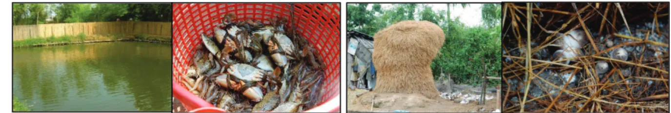
of shrimp ponds which belong to the fishery cooperative of Thuan Hoa village were broken and five hectors of ponds were filled up with flooded water and needed to be improved. Also, about 400 million VND of fishery equipment were damaged and three water pumping machines were broken. Furthermore, three tons of shrimp which were about to be harvested were lost and several tons of fish were lost.
Due to the intensive heavy rain, many roads were flooded and could not be used for many days. Especially the road from Thanh Phuoc hamlet to Thuan Hoa hamlet and from Thanh Phuoc hamlet to Van Quat Dong hamlet are seriously broken, causing the amount of damage at approximately 60,000USD. Also, the irrigation system which are closely connected with production was seriously damaged. The 23 sections of dyke system against salinity were broken. The longest part is 50 meter in length and 2 meter in depth. The economic loss is approximately 50,000USD. The inter-field irrigational system is also broken seriously with 9,061 meter in length. The primary and secondary schools were affected by floods; moreover, the students and teachers cannot go to school due to the damaged or flooded roads. Many teachers come from Hue City, therefore, they cannot go to Huong Phong school since the road connecting Huong Phong village with Huong Vinh village is often flooded. In spite of the severity of disasters, the people have coping strategies. In Huong Phong, aquaculture is one of their livelihoods especially for the people living near Tam Giang lagoon. Similar to the livestock in Huong Van, people sell the cultured fish before rainy season at lower price because they are afraid of the loss. The project showed the bamboo fence surrounding aquaculture pond which prevents fish from being swept away during inundation. Eight farmers made fence, as a result, they kept the fish during inundation and sold it at higher price after rainy season (see Figure 5). Another strategy is the diversification of income sources. The main income sources of Huong Phong are aquaculture of shrimp, fish, or crab and rice production. If the local people depend on monoculture as their livelihood, they will largely suffer when the disaster cause severe damages on the product. By using the rice straws, byproduct of producing rice, some people initiated mushroom production. They built the house made of rice straw and grew oyster mushroom in the house, keeping warm temperature and humidity in the house (see Figure 6). Also, some people try to culture a type of eels which can grow in the paddy field to diversity their income sources. In this way, the local people try their coping strategies in order to avoid the loss or decrease of income during the rainy season with the utilization of local resources.
4. CONCLUSION
Table 2 shows the summary of disasters and main damages and livelihood strategies of three sites. Based on the field research at three different sites, this paper finds flood, storm and whirlwind occurred
Figure 5. Bamboo fence surrounding pond and the products Figure 6. Rice straws and mushroom with the straw
continuously from September to November in 2007. The damages of the disasters differ by geographic characteristics of the three areas. Hong Ha is located upland area, so the damage is relatively less than the other two and especially no house was flooded. In Huong Van and Huong Phong; on the other hand, the serious damage was caused by the long inundation with high water levels, reaching up to 1.5 meters from the sea level. In 2007, the damage on human capital is not huge, but the damage on natural and physical capitals are serious in all three sites: the loss of cassava and rice in Hong Ha, cassava and pomelo in Huong Van and rice and fishery goods in Huong Phong. The people at three sites lost their main income sources which are very important for the local livelihood.
In the perspective of livelihood strategies, this study shows how local people tried to cope with disasters to decrease the damages of disasters. People engage in mainly three agricultural products: cassava, rice and maize. According to the crop calendars in Hong Ha, the local people try to adjust their harvesting period in order to avoid the large damage of the disasters. In Huong van, flooding causes serious physical damages: more than 25 per cent of houses in Son Cong hamlet are flooded. Due to people’s strategies of evacuating pigs before floods and keeping their feeds during rainy season, there was no severe damages on pig production although most people engage in animal husbandry in Huong Van. Also, how to earn a living during the rainy season is the strategy in Huong Phong as well. The people made a fence surrounding fish pond in order to avoid the loss of the cultured fish. Also, diversification of income sources is the strategy of decreasing the damages of disasters.
Disasters significantly influence people’s livelihood in central Vietnam. The damages differ by three sites, depending on each geographical characteristics and production systems. In all three sites; however, physical and natural assets was heavily damaged by disasters, stressing the importance of livelihood strategies to cope with disasters. Therefore, more and effective livelihood strategies are essential for the sustainable livelihood of local people.
Table 2. Summary of disasters and livelihood strategies at three sites
ACKNOWLEDGEMENT
I used to work for GSGES from 2006 to 2009. This paper is based on the research conducted by HUAF and GSGES researchers (Iizuka et al. 2011, Nguyen & Iizuka. 2007). I would like to thank my Japanese and Vietnamese colleagues and local people concerned in three sites. REFERENCES
Ashley, C., Carney, D. (1999) Sustainable livelihoods: Lessons from early experience, DFID, London, 47. Department for International Development (DFID) (1999) Sustainable Livelihood Guidance Sheets, DFID, London.
Iizuka, A., Tanaka, U., Ho, T. D. (2011) Enhancing livelihood strategies to cope with natural disasters in central Vietnam, Proceeding of Community and disasters, Japanese Agricultural System Society 2011 Spring, 17-18.
Iwasaki S. (2016) Linking disaster management to livelihood security against tropical cyclones: a case study on Odisha state in India, International Journal of Disaster Risk Reduction, 19 (2016), 57-63.
Thua Thien Hue Statistical Office (2007) Statistical Year Book 2006, Hue, Thua Thien Hue Statistical Office, 55, 56, 58.
Nguyen. T. H. M., Iizuka A. (2008) Survey on disaster damage on upland, plain, and coastal areas of central Vietnam in 2007, GSGES Asia Platform Annual Report 2007, Graduate School of Global Environmental Studies (GSGES) Kyoto University, 99-103.
Scoones, I. (1998) Sustainable Rural Livelihoods, A Framework for Analysis, IDS Working Paper 72, Institute of Development Studies, 7-8.
Hong Ha
(upland village) (flood plain) Huong Van (coastal village) Huong Phong
Main livelihood cultivation of
cassava, rice, maize, and vegetables
animal husbandry, cultivation of rice, fruits, cassava and vegetables
aquaculture, fishing, cultivation of rice and vegetables
Type of disasters flood (5)
storm (3) flood (5) flood (6) whirl wind (1)
Damage on human
capital none 1 person lost 2 people lost 25 injured by whirlwind
Damage on natural
and physical capital - cassava (19ha) - rice (1.6ha) - cassava (30ha) - pomelo (5ha) - livestock - pumping station - roads
- rice seedling (20ha) - shrimp (3t)
- inundation of fishery pond (5ha) - broken fishery pond, equipment, etc. - roads
- school
- irrigation cannels Livelihood
strategies/outcomes - timing of harvest - diversification - timing of selling pigs - construction of two-story pigpen
- producing fermented cassava as pigs’ feeds
- timing of selling fish - diversification
- bamboo fence surrounding aquaculture pond
-mushroom production