SoutMast Asian Studies, Vol. 28, No.4, March 1991
Rainfed Rice Culture and Population Growth
- - A Case Study at a Northeast Thai
Village--Yasuyuki
KONO*I Introduction
Paddy fields are mainly located on alluvial plains, where the topography is relatively flat and seasonal flooding brings necessary water and fertility for rice growing.
In
this sense, irrigation is artificial flooding. The worldwide distribution of paddy fields is concentrated in Monsoon Asia, including southern half of East Asia, Southeast Asia and the westernhalfof theIndian
subcontinent, where the world's larger alluvial plains are to be found.In
other words, rice cultivation is predominant in Monsoon Asia, because this region contains extensive land pro-viding a suitable natural environment.Under the natural environment of the alluvial plain, irrigation benefits rice cultivation by en-suring an adequate volume of water at the necessary time. Fanners can know in advance when and how much water they can receive. As a result, not only dose irrigation stabilize rice production,· it also enables fanners to intro-duce and to invest in new technologies. Though it takes a lot of money and labor to construct an irrigation system, farmers can long continue to benefit from it if it is maintained and managed well. It is not known whether rice cultivation employed irrigation when rice was first domes-ticated, but irrigation was certainly been used
*
iiiIl!f.Z., The Center for Southeast Asian Studies, Kyoto Universitysince very early times [Furukawa 1988]. The
area
of irrigated paddy land has gradually expanded in accordance with growth in popula-tion and the demand for rice. Water resources have also been reinforced in order to provide enough irrigation water for newly reclaimed fields and old but water-deficient fields. At first, headworks for diverting water from a river or stream were modified to utilize natural water discharge effectively. When the demand for irrigation water grew to exceed the natural water discharge, a reservoir or tank was con-structed in order to adjust water discharge to seasonal water requirement. As a further step, water transfer between catchment areas was tried.In
areas where the natural environment is suitable for rice cultivation, paddy field re-clamation and water resource development have thus occurred spirally and interdepen-dently, and irrigated rice culture has been ex-panded and elaborated.Such suitable areas are, however, unevenly distributed and of limited acreage in comparison with the demand for rice. Hence, rice must also be cultivated in areas with less suitable natural environments, where water resources are not abundant and it is technically and economically difficult to develop irrigation systems. Fanners there have to depend on rainfall. Even area where development of an irrigation system is technically feasible, this may take a long time to
506 - 56- it
complete, and fanners again have to rely on rainfed rice culture. Rainfed rice culture is thus practiced in inferior areas for rice cultivation and as emergency measures to absorb rapid population growth. Nevertheless, in Monsoon Asia, especially in the easternhalfof the Indian
subcontinent and Southeast Asia, rainfed rice culture prevails over a large area and will con-tinue to be a major type of agriculture in the future.
Northeast Thailand is one of the most domi-nant areas of rainfed rice culture in Monsoon Asia. The natural environment is not so suit-able for rice cultivation. Annual precipitation is about 1,300 mm, but rainfall is intennittent, with interval of one week to more than one month even in the rainy season. Water re-sources are scarce and the topography is un-suitable for developing an irrigation system.
Since the eighteenth century, the Lao popula-tion of Northeast Thailand has grown and ex-panded [Fukui 1988: 51]. They have estab-lished new settlements and reclaimed rainfed paddy fields. One of their major routes of migration was upstream along the Chi river from such provinces as Roiet and
Mahasar-akham through Khon Kaen and Udon Thani
[Kuchiba 1990: 203]. This type of migration is called ha na di in Thai, which means "to seek good paddy land." That is, they have migrated to areas which are comparatively suitable for rice cultivation, even though the natural en-vironment of the Northeast as a whole is less suitable. Because these better areas are of limited distribution, people often had to journey for several days or more to find land suitable for a new settlement [Hayashi 1985].
This paper focuses on a village in Khon Kaen province and in the middle of the Lao people's
migration route. After analyzing the process of paddy field reclamation and the balance of rice production and population growth in the village, I shall discuss the evolution and the limitation of rainted rice culture.
II The Hydrological Environment of Rainfed Rice Culture
1. The Natural Setting
DD Village is located about 15kmsouthwest of Khon Kaen city, at the northern edge of a gentle hill between the floodplains of the Chi and Mun rivers. The village's paddy fields are mainly located in the floodplain of the Chi river, north of the settlement.
The floodplain contains many small basins called nong. These are surrounded by low ridges which stand about 3 to 5 m above the bottoms of the basins and encompass acreages of from 20 ha to 50 ha. Villagers' paddy plots are scattered through about ten of these small basins.
Naturally, water ponds in the small basins during the rainy season and it remains for several months after the rainy season has ended. The depth of ponding at the bottom of each basin depends on its microtopography, but in some basins where the catchment area of the bottom, which is equal to the acreage of the basin, is comparatively large, it is more than 1 m. On the other hand, the area surrounding the bottom and the slope of the ridge cannot be expected to have ponding even in the rainy season, except when the Chi river overflows.
2. History ofHuman Settlement and Migration
The first settlers, consisting of three fami-lies, came to this area from Roiet province
- 5 8
-about the middle of nineteenth century [Fukui 1988: 106]. They settled on the edge of ahill
and opened paddy fields on the bottoms of small basins on the floodplain [Kaida 1985: 30]. One of the major works in opening paddy fields was to dig drainage canals connecting the bottoms of the small basins with the old river course out-side of the basins in order to drain ponded water. In most basins, however, the lowest
Part
was left as a small pond for fish culture. Several groups of settlers came later from Roiet and Mahasarakham provinces. They re-claimed other basins in the same way. After 1916, no large group of new settlers moved into the village [Fukui 1988: 108].From the 1930s, some villagers began to migrate from this village in search of good paddy land [Fukui 1988: 176]. Inthe interim, the area surrounding bottoms must have been reclaimed. This area is not naturally suitable for rice cultivation, but as suitable land had already been reclaimed, there was no other way for villagers to increase rice production to match population growth.
Though the destination of migrants from the village has gradually changed to big cities such as Bangkok since the 1960s, the tendency for emigration from the village has remained un-changed.
3.
Rice Cultivation Method and Drought
Avoid-ance Techniques
Rainfed rice culture at this village suffers flood. or drought damage almost every year. Flooding comes from the Chi river, and once flooding occurs, all the paddy fields on the floodplain are covered with floodwater for more
thanone month and the paddy crop ruined. The villagers have no effective countermeasures
508
against this type of natural disaster. Heavy flooding is infrequent, however, having occur-red four or five times in the last 60 years [Kono 1986: 149].
On the other hand, rice cultivation is in-fluenced by the seasonal distribution of rainfall and damaged by drought almost every year. Farmers have to pay constant attention to the weather during the rice cultivating period. They cannot predict precisely when and how much rain theywillhave. They know only that it will rain a lot in the rainy season, but not whether they will obtain a rice harvest that year.
Plots on the bottoms of small basins enjoy better hydrological conditions. These plots are fed by not only in-situ rainfall but also run-in water from their catchment area. Ifthe ponded water is too deep, it is drained through the drainage canal dug by the early settlers. As a result, drought damage is reduced and rice production is more stablethan in other parts of the basin. The newer plots around the bottoms and on the slopes of ridges have small catch-ment areas and are fed almost entirely by in-situ rainfall. Hydrological conditions are inevit-ably less stable and rice cultivation suffers from drought more severely and more frequently.
To utilize the unstable and unpredictable hy-drological conditions effectively for rice cultiva-tion, farmers have developed techniques to avoid drought damage. There are two impor-tant points involved [Kono 1986]. One is to adjust the rice cultivation period to the period of most favorable hydrological conditions, which varies from year to year and plot to plot. For this purpose, farmers can control the rice vari-ety to change the timing of heading and harvest-ing, and the starting date of transplanting to
,
,
"'.
l.fr.
I
match the best hydrological conditions. The other point is to keep as much water as possible in each plot. For this purpose, fanners can control the deep percolation rate and the fre-quency at which they check water conditions in their plot.
The effectiveness of these tedmiques was examined using the simulation model described later. As a result, these techniques were found effective in avoiding drought damage to some extent, but they can not decrease drought dam-age drastically. This means that the unsuitabil-ity of the natural environment for rice cultiva-tion in this village cannot be overcome by such cultivation techniques.
The rice cultivating methods employed in this
village are considered to have changed little since the first stage of reclamation was com-pleted. Some new technologies such as ferti-lizer application have begun to be introduced in
order to increase the rice yield per unit area, but they are not yet prevalent, nor is it certain that the hydrological conditions of this village can accept such new technologies. Hence, the increasing population must have been fed only by expanding the acreage of paddy fields onto less suitable land.
4. Rice Productivity
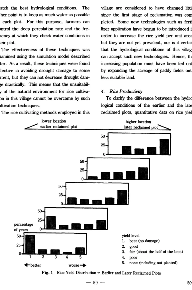
To clarify the difference between the hydro-logical conditions of the earlier and the later reclaimed plots, quantitative data on rice yield
lower location
L
earlier reclaimed plothigher location
later reclaimed plot"::==>.
yield level
1. best (no damage)
2. good
3. fair (about the half of the best) 4. poor
5. none (including not planted)
worse~ +better
~~
R:d
:~
....
~laJ::Ij
percen_
:L
~
of years 0. . . .,-=I::-IIJ
o
1 2 3 4 5should be shown. Rice cultivation in this village suffers from drought so frequently that rice yield is detennined mainly by the hydrological conditions of the year in question.
Every household at this village has a granary for storing rice in years of good harvest for consumption in years of poor harvest. The capacity of a granary roughly equals three years' consumption by a household. This means that fanners think in tenns not of annual rice production but of total rice production over several years. Actually, rice production fluctu-ates a lot [Kaida
et al.
1985], so rice productiv-ity cannot be judged from the observed data for a particular year, but must be judged from a long-term production record.To estimate rice productivity quantitatively, the drought and flood damage simulation model was developed [Kono 1986]. A record of rice yield over a long period can be obtained using this model. In this model, paddy fields in the village are divided into five groups. Each group has the same acreage, and the locations of the groups occupy successive areas from the bot-tom of the basin through the slope of the ridge. The probability distribution of rice yield for each group was estimated and is shown in Fig.
1. It is clear from this figure, that the plots located at the bottom of the basin and reclaimed earlier gave much better yields than those lo-cated on the slope of the ridge and reclaimed later. A rice yield better than "fair" can be expected four times in five years in the plots of lowest located group, but only about once in three years in the plots of the highest located group. This difference was caused by differ-ences in the size of catchment areas and in horizontal water movement both on the soil surface and under the ground.
III The Process of Paddy Field Expansion
Paddy fields in this village have been re-claimed from the bottoms of basins toward the slopes of their ridges in accordance with the village population growth. By 1983, when the survey was executed, about 80% of the flood-plain had already been reclaimed. The rest comprises mainly thehighland of the ridges and is used for farm roads, farm huts, vegetable gardens and bush. New reclamation seems to be almost impossible, because this area is also necessary for the villagers' life. This section examines the expansion of paddy land up to 1983 in order to investigate the balance of rice production and consumption.
1.
Available Data on
thePaddyField Acreage
Four sets of data are available for estimating the expansion of paddy fields.
(a) A map showing year of reclamation of paddy plots [Fukui
et al.
1985: 36-43].(b) A map of paddy plots reclaimed up to the 1930s [ibid. : 37-38].
(c) A map of paddy plots surveyed in 1981 and modified in 1983.
(d) Estimated village population after 1900 [Fukui 1988: 170].
Maps (a) and (b) were based respectively on interviews with the cultivators of each plot, and an elder villager who was about 55 years old in 1983. Though (b) and (c) covered almostallof the villagers' paddy plots, (a) covered about 60% of the villagers' plots in 1983. The years of reclamation in (a) and (b) did not coincide for a few plots, but generally they were in agree-ment. The data in (d) cannot be related directly with the acreage of paddy fields. By assuming a
,
1
l ~ ! t' 510 -60-balance between rice production and village population, however, the village population can be converted to the paddy field acreage. This is useful for the early yearin particular, for which the only available data on paddy field acreage are thosein (a), which are of lower credibility.
It is impossible to compare the credibility of (a) and (b), but in clarifying the process of paddy field expansion, (a) is more useful. Therefore, paddy field acreage was first esti-mated using (a). This estimation was then modified using (b), (c) and (d). The estimation period is from 1900 through 1983, because there is no data available for before 1900. 2. Method and Results
As a first stage, the paddy field expansion was estimated using (a). In (a), years of re-clamation are described variously, for example, "before 1912" or "1960-1961." Where there is uncertainly, the latest year mentioned is taken as the year of reclamation. This means that the acreage estimated by this method must be slightly less than the actual acreage of each year.
Map (a) does not cover all of the small basins where the villagers' paddy plots are distributed, and it also includes paddy plots of neighboring villages. It can be assumed, however, that the process of paddy field reclamation was similar in all villages in the locality and in the basins cov-ered by (a) and other basins in the locality. Therefore, it is assumed that the processes of the paddy field reclamation in the basins cov-ered by (a) and in this village's plots are the same. The basins covered by (a) are taken as the sample area for the estimation. The total acreage of the sample plots reclaimed up to 1983 is 223 ha, representing 63% of all of the
villagers' plots, and the total number of sample plots is 2,990.
With the above assumption, the acreage of paddy fields reclaimed during the period from 1900 through 1983 was calculated from (a). The results are shown in Fig. 2.
The acreage of paddy fields estimated from (a) was modified using(b)and (c). According to
(b), the acreage of paddy plots reclaimed up to the 1930s was 54% of that in 1983. And according to (c), the acreage of paddy plots reclaimed by 1983 was 245 ha in the sample area. This acreage is bigger than the acreage calculated from (a), because it includes some plots surveyed in 1983 for which (a) does not record the year of reclamation. These plots are located on higher ground than those described in (a). Therefore, the difference in acreage between (a) and (c) was assumed to represent plots reclaimed in recent years. Considering the results of (b) and (c), the modified expan-sion curve of paddy fields was drawn as shown in Fig. 2.
The expansion curve was also modified using (d). It is very difficult to assume a balance between population and rice production of this village throughout the estimation period. Some villagers said that the life was more severe in old times because they had to travel around looking for rice after successive years of poor harvests, even though they can now buy rice at town markets and also did so in the 1960s [Mizuno 1981: 48]. All that is certain is that villagers sometimes had to gain rice from out-side of the village after successive poor
bar-vests through the estimation period. As it is impossible to assume a balance between popula-tion and rice producpopula-tion, the acreage of paddy fields needed to feed the village population was
.
I
f.•
1980•
+-estimated acreage from a map an eldervillager drew(b)
• estimated acreage from populationdata (d)
• estimated acreage from interview data (a)
4 surveyed acreage in 1983 (c)
•
•
modification-+ considering (b) and (c) modification considering (d) O~----_r_----...,..----___,---r_....
1900 1920 1940 1960 yearFig.2 Estimation of Paddy Field Expansion
50 100 150 (ha) ---, 250,.. paddyfield acreage 200
provisionally calculated using the estimated average yield by the drought and flood damage simulation model. Annual per capita consump-tion was assumed to be 400 kg of unhusked rice.
The estimated acreage from the village population, also shown in Fig. 2, is larger than the expansion curve in 1900 and 1920, but smaller in 1935, 1965, 1975 and 1983. The
actual rice production fluctuated from year to year even in the early times when most of the plots were located at the bottoms of small basins. And it must have been a hard and dangerous job to travel outside the village to look for rice. Therefore, at least under the condition that the average harvest continued every year, rice production of the village must have been self-sufficient. According to this
,
,
"
r
I"' 512 -62-assumption, the expansion curve was modified as shown in Fig. 2.
3. Discussion
The year 1916 was the last year big group of settlers moved to this village. According to the estimated expansion curve, about one-fifth of the paddy plots in this village in 1983 had been reclaimed by 1916. These plots were probably to be located at the bottom of the small basins and are equivalent to the lowest located group assumed in the drought and flood damage simulation model. These facts reinforce the idea that the bottom of the small basins had been reclaimed already and that there were no unreclaimed basins left by this time, about 60 years after the first group of settlers migrated to the village.
Between this time and the 1930s, there was no large-scale migration into or out of the vil-lage. During this period, paddy fields were reclaimed very rapidly. Two-fifths of the paddy plots had been reclaimed by 1929 and three-fifths by 1935. During the period from the second half of the 1920s through the 1930s, the annual reclaimed acreage was nearly 10 ha for the whole village. These plots are located on land surrounding the bottoms. The gradient of the soil surface is not yet steep, and the hydro-logical conditions are still good compared to those of the higher plots.
From the 1930s, some villagers began to emigrate. The speed of paddy field reclamation slowed down, with four-fifths of the paddy plots being reclaimed by 1946, after which the annual reclaimed acreage became quite small. These plots are located on the slopes of the ridges. Rice cultivation in these plots suffers from drought almost every year and the rice
produc-tion is extremely unstable, as shown in Fig. 1.
IV Dynamics of the Balance of Rice Production and Consumption
Paddy field acreage cannot easily be con-verted into rice production in the case of rainfed rice culture, because rice yield differs greatly depending on the hydrological conditions of each plot. It is also dangerous to discuss the balance of rice production and consumption based on the average productivity, because the rice pro-duction fluctuates from year to year depending on the seasonal distribution of rainfall. This section first proposes a method to evaluate the instability of rice production from the viewpoint of self-sufficiency, then discusses the dynamics of the balance of rice production and consump-tion in the village based on the estimaconsump-tions made by this method.
1.
Method of Evaluation
Every household in the village has a granary for storing rice, with a capacity equal to three years' consumption. After paddy has been
har-vested and threshed, rice is brought to the granaries and stored. When it has all been consumed, villagers have to obtain rice by purchase or exchange. On the other hand, if
the granaries are full as a result of successive good harvests, rice is sold on the market or exchanged for something needed. Ifthe capac-ity of the granaries were to be increased, more rice could be stored, but storage losses would also increase. The behavior of the villagers mentioned above was incorporated into the simulation in order to evaluate the instability of rice production.
generated which preserved the statistical char-acteristics of the 17-year observed record. And a 100-year record of the annual per capita pro-duction of rice was estimated using the drought and flood damage simulation model. In this estimation, particular conditions such as paddy field acreage and the distribution of the plots must be given.
It was assumed that, apart from seed for the next year, the entire annual production of each household was stored in its granary, the capac-ity of which was three years' consumption. The volume of rice seed for next year and the annual per capita consumption were assumed to be 30 kg/ha and 400 kg, respectively, based on observations made in the village. Consumption was taken from the storage in a granary.
Annual storage loss was assumed to be 5%. Based on these assumptions, the volume of rice stored, the possible volume for sale, and the volume needed to be purchared each year were simulatedin order for long years.
Finally, the total volumes and the number of years each of sale and purchase in 100 years were obtained, and these values were taken as
indices of the instability of rice production from the viewpoint of self-sufficiency. The larger are the volume and the number of years of pur-chase, the lower are the stability of rice produc-tion and the degree of self-sufficiency.
In this evaluation, the instability under the given conditions was estimated by assuming that these conditions has persisted for more
than 100 years. Since this is not actually the case, the evaluation cannot take into account extraordinary circumstances or explain the
in-fluence of such circumstances. Nevertheless, it reflects the villagers' thinking. Those with chil-dren wonder whether their chilchil-drenwill be able in the future to produce enough rice from their paddy fields. Hthey conclude that their paddy acreage is too small for their children, they try to get more fields in the village or to open up new fields. Therefore, the evaluation by this method is considered valid in discussing the balance of rice production and consumption and its influences.
2.
Results and Discussion
The instability of rice production was
evalu-Table 1 Dynamics of the Balance of Rice Production and Conswnption
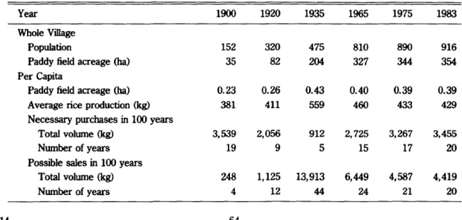
Year 1900 1920 1935 1965 1975 1983 Whole Village
Population 152 320 475 810 890 916
t
Paddy field acreage(ha) 35 82 204 327 344 354 ~
.
Per Capita :4iI Paddy field acreage (ha) 0.23 0.26 0.43 0.40 0.39 0.39 ItI
j
Average rice production (kg) 381 411 559 460 433 429 Necessary purchasesin100 years
Total volwne (kg) 3,539 2,056 912 2,725 3,267 3,455 Nwnber of years 19 9 5 15 17 20 Possible salesin100 years
Total volume (kg) 248 1,125 13,913 6,449 4,587 4,419 Nwnber of years 4 12 44 24 21 20 514 - 6 4
-I'
.
"
ll:\~
ated by the method described above. As the village population has been estimated for 1900, 1920, 1935, 1965, 1975 and 1983 [Fukui 1988: 170], the instability was evaluated for the same years based on the paddy field acreage and distribution for each year, as estimated in the previous section. The results are shown in Table l.
The per capita acreage of paddy land approx-imately doubled during the period from 1900 through 1935, since when it has remained con-stant. The frequency of the rice purchases decreased until 1935, since when it increased rapidly at first and gradually later. The fre-quency of purchase in 1935 was once in 20 years. This probability means a villager would have had to buy rice in one or two years in adult life. They must have known what to do in such a situation but regarded it as an emergency measure. Since 1965, the frequency has been around once in five years, which means that the situation would no longer be extraordinary. The villagers have to be constantly prepared for it. The frequency in 1900 was also estimated to be once in five years, but this high frequency might be a result of understirnation of the paddy field acreage, because there was plenty of unre-claimed land left
in
the village and it would have been very difficult to obtain rice from the out-side the village at that time. It is also possible, however, that at this time, when new migrants were still coming to the village, the villagers cultivated rice in the rainy season and opened new paddy fields in the dry season every year, and the acreage of paddy fields had not yet expanded enough to feed the villagers safely.In either case, there was often a deficit of rice in the first years of reclamation, but its frequency decreased in the 1920s and 1930s,
since when it has continued to increase. One more important point is that, even though rice was stored against years of poor harvest, the rice production of this village was not enough for complete self-sufficiency even in the 1920s and 1930s, when the best balance of rice pro-duction and consumption obtained.
Surpluses of rice have been small, and vil-lagers recognize the income obtained from sur-plus production as a bonus. Although rice may have been produced for sale as well as for home consumption in the 193Os, the villagers almost certainly gave priority to consumption over sale.
V Self-sufficiency and Rainfed Rice Culture
The first cash crop cultivated in the village was cotton, which was introduced during World War II. This was replaced in the late 1940s by kenaf, which in turn was replaced by cassava in the 1960s. Being cultivated in higher fields, these crops did not compete with rice. The road connecting the village with a national road was constructed in 1955 and paved with literate in 1966. Khon Kaen city, located about 20kIn from the village, has developed rapidly since the 1960s. A minibus runs between the village and Khon Kaen city. Opportunities for villagers to earn money in both agricultural and non-agricultural sectors have expanded considerably since World War II.
Before the 1930s, paddy plots in the village seem to have been reclaimed in accordance with the village population growth, and for this reason deficiencies in rice were infrequent. By this time, however, the lower parts of the small basins, more suitable for rice cultivation, had
already been reclaimed and only the more un-suitable areas were left. It was in just such a situation that the first cash crop was introduced into this village, though this was induced by a sudden rise in the price of cotton. Although paddy plots continued to be reclaimed in the village thereafter, their .production was low and unstable, and the acreage of newly reclaimed plots was not enough to feed the increased population. Nevertheless, the village population has continued to increase, because villagers have found new opportunities to earn money, such as cash crop cultivation, selling vegetables at the market and wage work, and they can buy rice at the market in years of poor harvest.
Thus, the villagers at first managed to ex-pand their paddy land and to remain self-sufficient in rice. Then when suitable land for rice cultivation became exhausted, it so hap-pened that cash crop cultivation was introduced. Thereafter they turned their endervors from maintaining self-sufficiency in rice towards earn-ing money from work outside rice cultivation. Rice cultivation remains one of the villagers' most important jobs, but it is no longer their only one.
While the above interpretation accords with my earlier estimation of the balance of rice production and consumption, its validity remains doubtful. Has any villagein Northeast Thailand ever preserved self-sufficiency in rice under rainfed safely?
At the end of the nineteenth century, paddy land was opened and rice production increased rapidly in the Central Plain. Many laborers and buffaloes went there from the Northeast to cultivate rice. Most of the laborers were sea-sonal workers. They also went to the North to work. for logging operations and were engaged
516 - 66
in railway construction Uohnston 1975: 226-234]. These job opportunities arose from their own particularcircumstances and they were not caused· by the imbalance between rice produc-tion and consumpproduc-tion in the Northeast. Never-theless, the Northeast could supply labor for such jobs. The same situation can be seen in the village when Gash crop cultivation was intro-duced. Whenever a profitable job arises, vil-lagers take the opportunity to earn money regardless of whether they can produce enough rice.
The image of rice culture in Japan seems to interfere with the consideration of rainfed rice culture and a society based on it. Rice culture in Japan has sophisticated irrigation systems and its production has been quite stable. Every-thing seems to be predictable for farmers and they can rely on their rice culture. But in
Northeast Thailand, fanners cannot rely on any-thing. They may be not able to produce any rice in some years. Even when the balance of rice production and consumption was bestinthe village's history, production was not enough for home consumption.
Rainfed rice culture cannot be relied on as a sole means of livelihood. It is always combined with jobs in other sectors of the economy and in other regions of the country, sometimes of foreign countries. And in Northeast Thailand, rainfed rice culture isrlominant because the area is not suitable for rice cultivation. The cultivation techniques for rainfed developed by fanners cannot overcome this unsuitability. Hence, villagers in the Northeast have always had their eyes open to the outside world. They have always been ready to go out and open new fields.
t
Acknowledgements
I wish to express special thanks to Prof. H. Fukui, CSEAS, Kyoto University, who encouraged me throughout the study. I also thank the members of DD Village Study and the villagers for their kind assistance and cooperation.
References
Fukui, H. 1988. Don Daeng: Agroecology of a North-east Thai Village (in Japanese). Tokyo: Sobunsha.
Fukui, H. et al., ed. 1985. The Second Interim Report, A Rice-Growing Village Revisited: An Integrated Study of Rural Deve/opment in North-east Thailand. CSEAS, Kyoto University.
Furukawa, H. 1988. Genealogy ofMiniature Wet Rice Fields-Spread of Oasis Culture (in Japanese). CSEAS, Kyoto University.
Hayashi, Y. 1985. Don Daeng Village in Northeast Thailand: Notes on Emigrant SettledinMo Nua Village, Udon 1bani Province (in Japanese).
Tonan Ajia Kenkyu [Southeast Asian Studies] 23(3): 280-294.
Johnston, D. B. 1975. Rural Society and the Rice Economyin Thailand, 1880-1930. Dissertation, Yale University.
Kaida, Y.; Hoshikawa, K. ; and Kono, Y. 1985. Don Daeng Village in Northeast Thailand: Instability of Rice Culture (inJapanese). Tonan Asia
Ken-kyu [Southeast Asian Studies]23(3): 252-266. Kono, Y. 1986. Study on the Rainfed Paddy
Cultiva-tioninthe Tropical Monsoon Area(inJapanese). Dissertation, the University of Tokyo.
Kuchiba, M, ed. 1990. Traditional Structure and Its
Changing Aspects in Don Daeng Village (in
Japanese). Tokyo: Sobunsha.
Mizuno, K. 1981. Social Organization of Thai Villages(inJapanese). Tokyo: Sobunsha.