Augmented telepresence using autopilot airship and omni-directional camera
2
0
0
全文
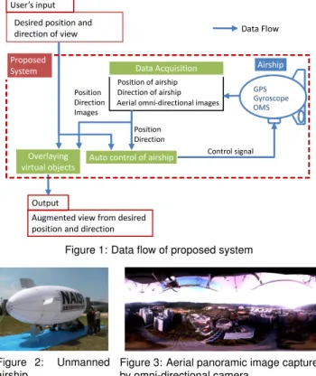
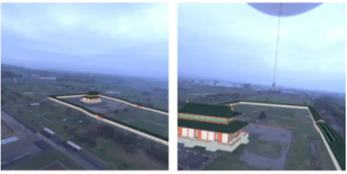
(2) 34.734. ▲: ●: ■:. ] ge34.7335 [d e d itut 34.733 a L. 34.7325 135.7325. 200. Origin of auto control End of auto control Waypoints. ]190 [m. C. deu185 itlt A180. B D 135.7335. A 135.7345. Longitude [deg]. B. 195. 135.7355. C. A. D. 50. 100 150 200. 175 170. 0. Time [s]. Figure 4: Trajectory of autopilot airship (Left: ground projection, Right: altitude): ‘∗’ in the figure indicates positions of airship every 50 seconds.. Position and direction of the OMS are determined by the extrinsic camera parameter estimation method [4] based on structurefrom-motion and GPS data. At present, real-time camera parameter estimation is not implemented for on-line telepresence. In extrinsic camera parameter estimation using GPS data in large-scale environment, feature tracking often fails mainly due to error of the GPS. To overcome the problem, a long video sequence is divided into short sequences with hundreds of frames. Neighboring sequences are overlapped, and estimated camera parameters on overlapped frames are integrated by weighted averaging. Direction information from gyroscope is used as initial direction of the OMS in each sequence. 2.3 Automatic control of airship To support changing user’s viewpoint efficiently, the proposed system provides user with the following two different approaches to control airship. 1. Following waypoints designated by user 2. Reducing DOF of remote control Each approach is detailed below. 2.3.1 Following waypoints designated by user In this approach, the airship is controlled to follow the waypoints using a proportional control scheme [5]. The points can be designated in advance or on the fly. This approach is suitable when the desired viewpoint is clearly defined. 2.3.2 Reducing DOF of remote control If desired position of viewpoint is not clear, it is required to control the airship to desired direction from current position. In usual remote control, the user should consider three DOF: speed, rudder, and elevation. This approach reduces DOF so as to control only speed and rudder, changing elevation automatically by using the proportional method [5]. 3 E XPERIMENTS 3.1 Prototype system To evaluate the proposed augmented telepresence system, we have carried out two experiments using a prototype system: • Automatic control of airship by designating points in advance, • Overlaying a virtual object on stored images captured from the airship. Our unmanned airship shown in Figure 2 was used for a prototype system. The airship equips an OMS (Point Grey Research, Ladybug3), a differential-GPS (Hitachi Zosen Corporation, P4-GPS), and a fiber-optic gyroscope (Tokyo Keiki, TISS-5-40). All sensors were connected to a laptop PC on the airship to store and transmit captured data. Another PC placed on the ground was used to generate control signal for the airship. A transmitter was connected to the PC on the ground to transmit control signal to the airship.. Figure 5: Examples of user’s view from different viewpoints. 3.2 Automatic control of airship In the experiment about automatic control, the airship was controlled around two points (230 m distance, 70 m altitude from the ground). The airship was controlled manually during takeoff and landing. Position and direction of the airship and control signal were generated in 4 Hz. Figure 4 illustrates a trajectory of the autopilot airship. For the most part, the airship was controlled around the points. However, sometimes the airship drifted from the points mainly due to measurement error of the gyroscope. 3.3 Overlaying a virtual object Virtual objects were overlaid on omni-directional images in offline processing because of the difficulty of omni-directional image transmission in the present system configration. The airship was controlled manually during capturing aerial images. In the experiment, a 3D model of an old palace in Heijo-capital was overlaid on a defunct base of the palace captured by the prototype system. The 3D model was successfully overlaid at appropriate positions in varying user’s views as shown in Figure 5. 4 C ONCLUSION AND FUTURE WORK This paper has proposed a large-scale augmented telepresence system using aerial images captured from unmanned airship. The autopilot airship supports to change position of user’s viewpoint, and an omni-directional camera realizes to change user’s viewing direction without rotation of the airship. A GPS and a gyroscope are equipped on the airship to measure position and direction of the airship and the OMS. The experiments have shown that the airship can be controlled appropriately for most part, and a 3D model of an old palace is overlaid at appropriate position on a defunct base of the palace. In future work, real-time transmission of omni-directional images is required as well as real-time extrinsic camera parameter estimation to realize a real-time augmented telepresence system. ACKNOWLEDGEMENTS This work was supported in part by the “Ambient Intelligence” project granted by the Ministry of Education, Culture, Sports, Science and Technology. R EFERENCES [1] S. Lawson, J. Pretlove, A. Weeler, and G. Parker. Augmented reality as a tool to aid the telerobotic exploration and characterization of remote environments. Presence, Vol. 2, No. 4, pp. 352–567, 2002. [2] H. Kim, J. Kim, and S. Park. A bird’s-eye view system using augmented reality. In Proc. of the Thirty-Second Annual Simulation Symposium, pp. 126–132, 1999. [3] S. Ikeda, T. Sato, and N. Yokoya. High-resolution panoramic movie generation from video streams acquired by an omnidirectional multicamera system. In Proc. of IEEE Int. Conf. on Multisensor Fusion and Integration for Intelligent System (MFI2003), pp. 155–160, 2003. [4] Y. Yokochi, S. Ikeda, T. Sato, and N. Yokoya. Extrinsic camera parameter estimation based-on feature tracking and GPS data. In Proc. of Asian Conf. on Computer Vision (ACCV2006), Vol. 1, pp. 369–378, 2006. [5] E. Paiva, J. Azinheira, J. Ramos, A. Moutinho, and S. Bueno. Project AURORA: Infrastructure and flight control experiments for a robotic airship. J. of Field Robotics, Vol. 23, No. 2–3, pp. 201–222, 2006..
(3)
図
関連したドキュメント
Notice that for the adjoint pairs in corollary 1.6.11 conditions (a) and (b) hold for all colimit cylinders as in (1.93), since (F ? , F ∗ ) is an equipment homomorphism in each
Making use, from the preceding paper, of the affirmative solution of the Spectral Conjecture, it is shown here that the general boundaries, of the minimal Gerschgorin sets for
Keywords: continuous time random walk, Brownian motion, collision time, skew Young tableaux, tandem queue.. AMS 2000 Subject Classification: Primary:
This paper presents an investigation into the mechanics of this specific problem and develops an analytical approach that accounts for the effects of geometrical and material data on
A bounded linear operator T ∈ L(X ) on a Banach space X is said to satisfy Browder’s theorem if two important spectra, originating from Fredholm theory, the Browder spectrum and
While conducting an experiment regarding fetal move- ments as a result of Pulsed Wave Doppler (PWD) ultrasound, [8] we encountered the severe artifacts in the acquired image2.
Wro ´nski’s construction replaced by phase semantic completion. ASubL3, Crakow 06/11/06
p≤x a 2 p log p/p k−1 which is proved in Section 4 using Shimura’s split of the Rankin–Selberg L -function into the ordinary Riemann zeta-function and the sym- metric square
