On
the Origin of the Joints iri the Futaba
Area
of the Joban
Coal-Field, Fukushima
Prefecture
Shinobu MiTSUI*、、Kazuo HOSHINO**、Tomomasa Hashimoto** Kazuo Inami** and Akira SAGAwA***I、ls£itute of Geolog:y、Faculりof Li teratur・ea、idScience、 **Geological Socieりof Japan
Abstract
・ The
purpose of the present paper is to interpret the origin and period of the
joints developed in the Cretaceous and Tertiary systems distributed in the Futaba
Area
of
the Joban coal-field,Fukushima
Prefecture。
The
joints in the investigated area were classifiedinto four stages,
1) joints with strikes
oiwNW-ESE
to WSW-ENE
in the Futaba-, Shiramizu-,
and Yunagaya
groups are the
oldest and were formed by the structural control of the basement rocks ; 2) dominant joints
with NNW-SSE
to NNE-SSぺV
strikein the Yunagaya
Group are closely related to the Futaba
thrust fault that was formed
prior to the sedimentation of the Izumi
Group,
and probably
by the same
stress as the thrust fault; 3) predominant
NNW-SSE
to NNE-SSW
trending
joints in the Izumi Group
are tension joints formed
under
the stress fields inwhich
the
maximum
tensil principal stress lies with about horizontal angle towards the east or west
when
the maχimum compressive principal stress was released after the reaction of the Futaba
thrust fault after the deposition of the Izumi
Group ; and,
4) joints with
WNW-ESE
to
WSW-ENE
strike in the Izumi Group
and Yamadahama
Formation
are the youngest‘tension
joints, and were formed after the development
of the joints with NNW-SSE
to NNE-SSW
strike in the Izumi
Group.
INTRODUCTION
AND
ACKNOWLEDGMENTS
In general, faults are defined as fractures in rocks in which the opposite walls have moved past each other to produce a displacement, whereas joints are defined as fractures along which there is little or no displacement (Badgley, 1965 ; Billings, 1966). Usually joints occur in sets, although the mean densities and patterns of the joints are considerably variable in different rock materials. Concerning the origin, joints are classified into tension joints parallel to a maximum compressive principal stress, and shear joints oblique to the stress・ Generally, they are related to the regional geological structures. Also, joints are differentiated into systematic joints and non-systematic joints CBadgley, 1965). The systematic joints are generally related with and applied in interpretation of the geological structure, from the following reasons ; 1)The non-systematic joints are formed by tectonic origin and are due to physical and chemical causes. 2)The systematic joints commonly possess planar surfaces, whereas the non-systematic joints show random curvilinear pattern, and this brings about difficulty in their application。
Because joints are closely related to the geological structure as the faults, many authors have reported on the joints associated with the regional geological structures (Hoshino, 1965 ;
2 高知大学学術研究報告 第21巻 自然科学 第1号
/丿
0 10 20 KML=∃==1
N心十ト
0エFTト
5 10 KM →一一→犬T祠jmノ 心
﹃/
I ; i ・ ・ d , ● . . ぷ ● i . ヽ ‘Fig. 1. Index map of the investigated area.
・ l「 . 1
Hirabayashi, 1964 ; Murai, 1965, a, b, 1966, . 1967 ; Yamaguchi, 1965 ; Hiranoレ1969;
Kitamura', 1962 ; Mitsui, 1971). ・I・ 二
The purpose of the present paper is to interpret the origin and period of the joint develoびed
in the cover rocks (Cretaceous and Tertiary sedimentary rocks) distributed in the Futaba
1
Area (Fig. 1) of the Joban coal-field. Fukushima Prefecture, and to describe the relationship
between the joints and the Futaba thrust fault, which is the most remarkable major fault in
φe Futaba Area and was named previously as the Hisanohama-Iwanuma dislocation line by
Yabe and Aoki (1924).
In addition to this study. experiments under high confining pressure undertaken for the
rocks of this region by the present authors. Detailed discussion on the results and geological
, ●applications will be reserved for another opportunity・ .,
Acknowlegments are due to Prof. Nobu Kitamura of the Institute of Geology and
Paleontology, Faculty of Science, Tohoku University, and Jun-ichi Iwai, Professor
Emeritus of the Tohoku University, for directing the field and laboratory works. Deep
appreciation is due to Professor Kotora Hatai of the Institute of Geology and Paleontology,
Tohoku University for his kind guidance and critical reading of the manuscript, and to DrS・
Masatora Kawai, Toshihiro Kakimi and Masatoshi Sogabe, all of the Geological survey
of Japan, for their suggestions on stratigraphic and geostructural problems relevant to the
present study. Thanks are also due to Professors Takeo Sawamura and Tiro Katto both of
the Institute of Geology, Faculty of Literature and Science, Kochi University, for their
igin of the joints in、the. Futaba Area, of。the Joban Goal-Field、 Fukushima Pref. 5 ㎜㎜■㎜
STRATIGRAPHY \
・The stratigraphic classification in the Futaba Area is shown in Pig:. 2, and briefly outlined helo'w and the geological map is shown in Fig. ろ.
The basement rocks of the cover rocks (Cretaceous and Tertiary sediments) in the surveyed area are the Abukuma metamorphic rocks, the Paleozoic rocks and pre-Tertiary granitic rocks. The Paleozoic rocks are Permian in age and called the Takakurayama Group (Yanagi-sawa, 1967). The group consists of black slate, sandstone conglomerate and phyllite, etc.,
AGE GR. FORMATION MEMBER THICK. COLUMN ROCK FACIES
U 」 Z L よ 」 U O − _ J Q 。 L J Z U 』 ○ ○ 山 山 Z Z . 山 U O ・ ← = 噂 Σ Z L J U 訴 追 ' I - t j ○ 山 t A ⊃ O a i U μ 山 c 「 U ヘ ノ 心 ¥ | ≪ ト 戸 隠
?
μ
YAMADAYAMA F. 匹 SEKINOUE F. 四 NAKAYAMA F. 四 ⇒ 匹 MISAWA SANDSTONE M. づご MUDSTONE M. 41m 心 164m m 20m 四 250 md(1「k olive mica, siltstone・with pumice and carbonate fragments
yel【ow to brown mica, sandstone
●●●●●●● ぇ。乙ぶ
dark olive mica, siltstone with sand-stone thin layers
一一一一一 フ匹匹 OOOOOOO Jり、タヽSもむ収Jり、S ●●●●●・● ::ニ::::::::::: ごニ:::::::::: ごニごご ら a. ⊃ O Q] ○ g ≪ ○ ≪ Z ⊃
>-sandstone, tu↑f,conglomerate
TAIRA F.
yellowish to reddish brown granule to m惣昌司笥7(北畠訟尚
135 m
こ
dj忿r?egrQy to dark olive tuffaceous
£一一一一
KAMENO-0 F. 135 m
蔚昌mご昌t次次ぷ‰
Å
MIZUNOYA F. 80m ` ゞ dark olive micaceous mudstone ''
GOYASU F. 70m
● ● ・ ● ● ● ●
brown color fine grained sandstone reddish brown gr. to eb. conalomerafe bearing arkose c.s(ln孟tone wiw4 P lignite layers ● ● ● ● ● ● ● 〃 O O B ≫ ● 申 ● ● ● ・ ・ @ ● @ a a O O ● ● ● ● ● ● ● ○ ● a ● ● ● ● ● ● ● KUNUGIDAIRA F. 心 SHIRASAKA F.
四
110 m ぺ 100 m - 一 一 一 一sandstone and mudstone grayish white rhyolitic tuff and rh olite lava
pelgble to cobble size conglomerate
● ● ● ● ● ・ / \ / S / X / 's. / Sv y V / V QOOOOOD OOOOOOO O○OQOOO り゛Jふ&4λJりヽ Q . ⊃ O Q こ ○ ⊃ N − Σ ≪ Q こ 一 工 C / 7 へ / 心 ○ ≪ f f l ≪
dark gray shaly mudstone or shale
・ASAGAI F. 80m ●●●●●●● ::::::M
3穴ぬ≒否認回流かe
stratifi- IWAKI F. 四 TAMAYAMA F.匹
110 m 四 80m ・ 申 ● ● ● ● ● a a o o a o O O a O ● O O a ● ● ● ● ● ● ●m‰旨認諾恰U匹昌穴み
;‰。t。cobb【e
size con lomerate
・・
with sandstone and coal
lyers
0 0 O 0 0 O 0 0 0 0 0 0 0 0 応 、 7 . 、 O 0 O O 0 coal
arkose coarse grained sandstone
● ● ● ● ● ● ● ● ● ● ・
KASAMATSU F. 160 m ● ● ● ● 嘩 ● ● ● ● ● ● ● ● ●
coal
arkose c. sandstone with mudstone ? ASHIZAWA F. 訃竺七三 BASEMENT ROCKS
W
80m
W
●●●●●●●薗
fine to medium
grained sandstone
granodiorite, amphvbolite, schist, slate limestone, sandstone, ets.
G・,GR・.:GROりP,Iz.:IZUMI, THICK.:THICKNESS
Fig. 2. Generalized stratigraphic sequence of the Futaba Area of the Joban
4 高知大学学術研究報告 第21巻, 自然科学 第1号
with intercalated small fossiliferous limestone lensesン
The cover rocks are composed of the Cretaceous and Tertiary sediments.
The Cretaceous Futaba Group overlies the basement rocks with unconformity. and is superposed by the Tertiary with unconformity. The Futaba Group is subdivided into the Ashizawa-, Kasamatsu-, and Tamayama for皿ations. The・Ashizawa Formation is Early Cenomanian in age and consists generally of massive fine grained sandstone attaining about 100 to 200 meters in thickness. The Kasamatsu Formation, about 140 meters in thickness, consists mainly of coarse grained arkose sandstone and is intercalated with layers of mudstone and lignite. The Tamayama Formation, 60 t0 120 meters in thickness, is composed mainly of coarse grained arkose sandstone with conglomerates and crosりamination in part and with intercalated lignite layers in the upper part. ,'゛
In this area the Tertiary sedimentary rocks a邨 classified, from the older to the yotinger, into the Shiramizu Group, Yunagaya Group, Nakayama Formation, Izumi Group and the
Yamadahama Formation. The Izumi Group and Yamadahama Formation are correlated with the Taga Group by Sugai and Matsui C1957) and Iwaりand Matsui (1961).
The Shiramizu Group is subdivided into the !waki・Formation, the Asagai Formation and the Shirasaka Formation in upward succession 呻d represents a transgressive facies. The Iwaki Formation lies on the Cretaceous Futaba Group with vmconformity and is about 100
meters thick. It is composed mainly of pebble to cobble size conglomerates intercalated with layers of coarse grained conglomerate bearing sandstone, fine to coarse grained sandstone, mudstone and coal. This Formation shows some cyclic sedimentation, comprising mainly conglomerate CEguchi et al.バ954). The Asagai F(μ・matioh consists of fine grained sandstone. but with discontinuous conglomerate beds near the boundary with the Iwaki Formation in the vicinity of Shinyashiki, Hirono・cho and on the south side of the Kido River. The Shirasaka Formation is composed of massive shaly mudstone showing good development of
joints・
The Yunagaya Group lies on the Shiramizu witトunconformity and is superposed by the Nakayama Formation with unconformity. This Group is subdivided into the Kunugidaira-, the Goyasu-, the Mizunoya-, Kameno-0-, and the Taira formations. The latter is subdivided into the Honya Mudstone and the Misawa Sandstone members.
The lower part of the Kunugidaira Formation consists mainly of conglomerate with con-glomerate-bearing sandstone and the upper of rhyolitic tuff intercalated with rhyolite lava. The uppermost part is of tuffaceous shale and coarse grained sandstone. The Goyasu Formation consists mainly of granule to pebble size conglomeratebearing medium to coarse grained arkose sandstone and is intercalated with layers of lignite (10 to 30cm thick) and pebble size conglomerate in the lower part. The Mizuncが1 Formation is about 80 meters in thickness and composed mainly of tu任aceous mudstone intercalated with the layers of sandstone near the boundary with the Goyasu Formation. In this Area this formation does not form a large scale alternation of mudstone and sandstone as in the Iwaki North and Iwaki South areas (Mitsui, 1971). The Kameno-0 Formation is composed of purplish gray stratified and laminated shale with the remains of molluscs and intercalated with layers of medium to coarse grained sandstone in the middle and upper part, which form the
alter-On the Oriein of the Joints in the Futada Area of the Joban Coal- Field) Fukushima Pref. 5
nation. In the alternation layers this formation shows interformational abnormal
deposition
(Iwai, 1953). The Honya
Mudstone
Member
interfingerswith the Misawa
Sandstone Member
and attainsa thickness of 100−150 meters. The lower part of this Member
is composed
of
ah alternation of mudstone
(dominant)
and sandstone.
The
middle to upper parts consists
of massive shaly mudstone with molluscan and foraminiferan remains. The Misawa
Sandstone
Member
is mainly of granule to pebble size conglomerate-bearing medium
to coarse grained
arkose sandstone showing
the good development
of cross-bedding.
The
Nakayama
Formation is distributed between
Yusuji
and Hisanohama
with strike of
NNW-SSE.
It is composed
of basal conglomerate
which
comprises gravels of andesite and
basalt, etc.
The
Izumi
Group
CMitsui, 1971) lies with unconformity
upon the Nakayama
Formation
and consists only of the Sekinoue Formation (Mitsui, 1971) in the Futaba Area. The Sekinoue
Formation is composed
mainly of dark olive siltstoneintercalated with thin layers of medium
to coarse grained sandstone and yields fossilmolluscs, foraminifers and diatoms. From
the
molluscan
and foraminiferan fossilsthe formation is Early Pliocene in age.
The
Yamadahama
Formation
(Mitsui, 1971) ovelies the Sekinoue Formation
Formation
with unconformity.
The lower part of the formation is composed
mainly of fine to coarse
grained sandstone
with abundant
molluscs and
the upper part is of dark
olive massive
siltstonewith thin layers of sandstone. ,.
GEOLOGICAL
STRUCTURE
In the Futaba Area, the major geological structures are the Futaba fold structure. the Futaba thrust fault, and the unconformity between the Nakayama Formation and the Izumi Group・
The Futaba fold structure with N10°−20°w strike extends northwards from Yusuji to the north of Iriumi spa and consists mainly of one syncline and one anticline, which shows isoclinal folding with westward dip.
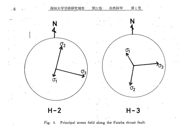
Field observations suggest that the Futaba fold structure was formed under the stress field where 03 the maximum compressive principal stress, lies nearly in east or west direction with horizontal angle (Fig. 4). Whereas, the cover rocks were deposited successively in upward sequence from the west towards the east. But, the dips of each formation are not equal. Namely, when the dips of each formation west of the Futaba thrust are observed, the Futaba Group and the Iwaki Formation dips at 10°−15°E, the Asagai and Shirasaka formations at 20°−40°E,and the Yunagaya Group and the Nakayama Formations show dips of 50°−80°E or W. Whereas, in the east of the Futaba thrust, the Izumi Group dips at" 10°E, and already reported by Ninagawa (1954) shows that the formations older than =
the Izumi Group were not folded and dip eastwards gently. Also a remarkable angular unconformity is developed between the Yunagaya Group or Nakayama Formation and the Izumi Group (Fig.ろ), indicating a considerable tectonic movement between the two groups.
Hence, this fold structure was originally a neχualfold which subsequently transformed into the present structure by the horizontal stress of the tectonic mOvement, before the deposition
1 r ゝ 6 高知大学学術研究報告 第21巻.・ 自然科学 第1号
N
H-2
N
H-3
Fig. 4. Principa】stress field along the Futaba thrust fault.
of the Izumi Group.
The
Futaba thrust fault extends with N-S
to NNW-SSE
trend along the western margin
of distributionof the Izumi Group‘from Yusuji
Hirono・cho
to the vicinity of Iwanuma-cho,
Miyagi
Prefecture and is equivalent to the“Hisanohama-Iwai!uma
dislocation line” of Yabe
and Aoki (1924). It is considered that the thrust was formed before deposition of the Izumi
Group
but again reacted after development
of the Izumi Group,
because the thrust fault cuts
the Izumi
Group
and is covered in part by the sedi皿entary rocks of the Izumi Group.
The
movement・ of the reactive faultis considered to have been slight from
the following reasons,
that is, ' 1) the shear along this thrustis small.
2) the pumice
grains contained in the
Izumi
Group
adjacent to the thrust are littledeformed
and 3) the thrust is discontinuous
(Tsuneishi,
1966).
METHOD OF JO]:NT STUDY
The method of investigation of the joints with' the geological structure were according to Mur尽i'sreport C1965)。
In order to observe the state of development of the joints in detail, it is advisable to measure the joints of different rock materials. Because each formation in the investigated area is classified, on the whole, by the rock facies, it does not contradict to consider that 出e measurement of the joints of each formation, agrees with that of each different kind of rock materials. Accordingly, the joints in each:formation are measured in this paper. The stastical method was done in the following order・; at (きach locality the strike and dip of ■ l i 1
30 t0 50 joint planes were measured, and a distribution dli昭ram was made by plotting the poles・ perpendicular to the joint plane on the lower hemisphere of the Schmidt equal-area
net, :and then by drawing
the c(χitour
lines in the net.
The
predominant
direction of the
observed joints are shown
for ・each group in Figs. アー9.
MEAN・ DENSITY OF THE JOINTS
For the analysis of the joints, the mean density of the joints at each locality was determi一 所d because of its usefulness to interpretate the development of the joints. Here, the mean denがtyis。defined as the ratio of the number of occurrence of the joints to the interval in
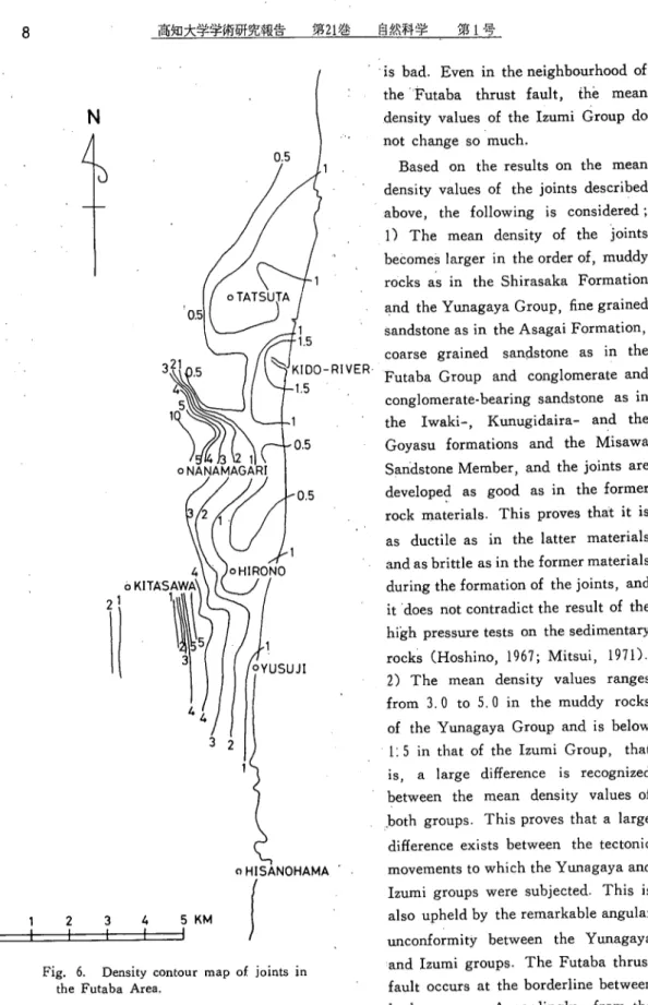
meters (number / meter). The mean density of the joints in the Futaba Area is shown in Fig. 5. Also, the density contour map of the joints is shown in Fig. 6. :
The Futaba Group consists mainly of coarse grained sandstone and the mean density values are from 1.0 to 2.1 numbers / meter. The value is below 1.0 in the Iwaki Forma-tion which is composed mainly of conglomerate and conglomerate-bearing coarse grained
sandstone. In the fine grained sandstone of the Asagai Formation and mudstone of the S!lirasaka Formation the mean density ranges from 3.8 t0 5.0 and the development of the joint is good.. In the conglomerate and conglomerate-bearing coarse grained sandstone of the Kyu!ugidaira Formation and conglomerate-bearing coarse grained sandstone of the Goyasu Formation the, mean density values are below 1.0. The Miziinoya and Kameno-0 forma-tions and‘theHonya Mudstone Member of the Taira Formation consist of muddy rocks that ’j
have been influenced strongly by the movement of the Futaba disturbed zone and the mean density values are 3.0-5.0. The value is below 1.0 in the Misawa Sandstone Member of Φ 1 1
the Taira Formation which is composed mainly of conglomerate-bearing coarse grained |
sandstone. In the Izumi Group and the Yamadahama Formation both composed mainly of tuffaceous muds tone, the mean density value is less than 1.5 and the development of joints
’7 CD Eこωoc 5 4 0 0 C M 1 0
Fig. 5. Mean density of jointsin the Futaba Area.
FuこFutaba Group, Iw :Iwaki Formation, As :・Asagai Formation Si : Shirasaka Formation, Ku : Kunugidaira Formation, Go':Goyasu Formation Mz : Mizunoya Formation i ., Km: Kameno・o Formation, Ho z Honya Mudstone Member, Mi:Misawa- Sandstone Member, Iz : Izumi Group, Ya : Yaraadahama Formation
8
N丿千丁ト
高知大学学術研究報告 第21巻 自然科学 第1号 o KIT 3喩暫り
fFig. 6. Density contour map of joints in
the Futaba Area.
is bad. Even in the neighbourhood of the ’Futaba thrust fault, the mean density values of the Izumi Group do not change so much.
Based on the results on the mean density values of the joints described above, the following is considered ; 0 The mean density of the joints becomes larger in the order of, muddy rocks as in the Shirasaka Formation
吋
sandstone as in the Asagai Formation, coarse grained sandstone as in the Futaba Group and conglomerate and conglomerate-bearing sandstone as in the Iwaki-, Kunugidaira- and the Goyasu formations and the Misawa Sandstone Member, and the joints are developed as good as in the former rock materials. This pro▽esthat it is as ductile as in the latter materials andas brittle as in the former materials during the formation of the joints. and itdoes riot contradict the result of the high pressure tests on the sedimentary rocks CHoshino, 1967; Mitsui, 1971). 2) The mean density values ranges from 3.0 t0 5.0 in the muddy rocks of the Yunagaya Group and is below ユ:5 in that of the Izumi Group, that
is, a large difference is recognized between the mean density values of .bothgroups. This proves that a large difference exists between the tectonic movements to which the Yunagaya and Iztuni groups were subjected. This is also upheld by the remarkable angular unconformity between the Yunagaya and lzu皿igroups. The Futaba thrust fault occurs at the borderline between both groups. Accordingly, from the (!ifferenceof the mean density values,
On the Origin of the Jointsin the・Futaba Area of the Joban Coa】-Fie】d,Fukushiraa Pref. 9
it is considered that the Futaba thrust fault was formed before deposition of the Izumi Group,
and that the thrust strongly affected the Yiuiagaya Group.
3)Themean
density values in
th(きmuddyrocks of the Izumi
Group
are below 1.5, and this value is not very large even
near to the Futaba thrust. The
Futaba
thrust fault cuts the sedimentary rocks of the Izumi
Group
and is also covered by the group. Hence,
from the small value and invariability of
the mean
density of the Izumi
Group,
it is considered that the reacted Futaba thrust fault
was not large so much
in scale and had only littleinfluence on the Iziimi Group.
This is
also upheld by that the pumice
grains contained in the Izumi Group adjacent to the thrust
are littledeformed.
JOINT
SYSTEM
OF EACH
FORMATION
(Description)
In the basement composed of granitic and metamorphic rocks, the predominant joints strike N60°E一N60°χv with dips of 70°−90?N or S, and strike N100ぺV一N30°E with dips of 65°− 90°E or w, whereas those with N-S strike and with 10w dip are rare. In the Futaba Group, the predominant' ones have N70°E一N60°ぺV strike and dips of 500−900Nor S. The other predominant ones strike N一S and dip at 800−90°E or W. In the Iwaki Formation。 the dominant joints strike N55°E-N55°W with dips of 55°−85°N or s, and strike N5°E− N35°W with dip of 75°−80°E or W, whereas those with NW-SE strike are rare. In the Asagai Formation, the most dominant joints strike N60°E-N70°W with dip of 55°−90°N or S, and the dominant ones of second rank strike N10°−30°W with dip of 50°−70°E or W, whereas those with NVV一SE strike are rare. The dominant joints in the Shirasaka Formation have faces with N75°E一N70°ぺV strike and dip of 55°−85°N or S, and N5°− 20°E strike and dips 60°−85°E orべA^, whereas, those with NIV一SE strike are rare. In the Kunugidaira Formation, the most predominant trends are N75°E−N60°W (dips 55°−90°N or S) and the predominant ones of second rank have N10°E-N15°W (dips 50°−85°E or W), whereas those with NE − sw strike are rare. In the Goyasu Formation the dominant joints strike N60°E-N60°W with dips of 40°−70°N or S and strike N15°E−N30°W with dips of 65°−859EorべA'^,whereas those with NE一SべV strike are. rare. In the Miziinoya For-mation the most dominant joints have faces with N15°E一N30°w strike and dips of 40°− 85°E or w and the dominant ones of the second rank are with N55°E一N65°w strike and dips of 65°−85°N or S, whereas those of NE-SW strike are rare. In the Kameno-0 For-mation the predominant ones have N20°E−N30°W strike and dips of 70°−90°E or ぺN. The other predominant ones strike N65°E一N60°ぺV and dip at 50°−90°N or S, whereas those with Nχ,V-SE and NE一sw strikes are rare. In the Honya Mudstone Member of the Taira Formation the dominant joints strike N85°E一N70°W with dips of 40°−90°N or S and strike N25°E-NIO°W with dips of 70°−90°E or W, whereas those of NW-SE strike are rare. In the Misawa Sandstone Member of the Taira Formation the dominant trends are WNW-ESE to WSW一ENE and NNW-SSE. In the Izumi Group bordering the Futaba thrust
fault, the predominant joints have faces with N30°E−N30°W strike and dips of 35°−85°E or W, and the predominant ones of the second rank have N70°E一N60°べV strike and dips of 40°−85°N or S, whereas those of NE-SW and NW-SE strike are a
10
Nノ詣丁ト
矢
高知大学学術研究報告 第21巻. 自然科学 第1号六千上作
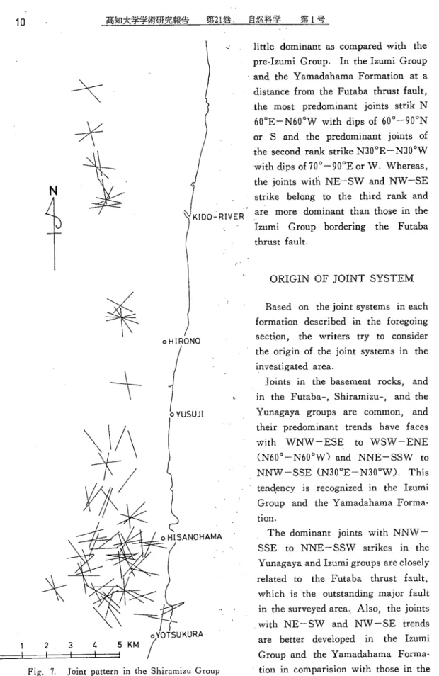
羊 十
0 1 2、3 4 1 t KIDO一一RIVERFig. 7. Joint pattern in the Shiramizu Group
little dominant as compared with the
pre-Izun!i Group. In the Izumi Group
and the Yamadahama Formation at a
distance from the Futaba thrust fault。t屈耳lost predominant joints strik N
60°E−N60°w with dips of 60°−90°N
or S and the predominant joints of
the second rank strike N30°E−N30°w
with dips of 70°−90°E or ぺV.ぺA^hereas,
the joints witli NE-SW and NW-SE
strike belong to the third rank and
are more dominant than those in the
Izumi Group bordering the Futaba
thrust fault.
ORIGIN
OF
JOINT
SYSTEM
Based on the joint systems in each formation described in the foregoing section, the writers try to consider the origin of the joint systems in the investigated area。
Joints in the basement rocks, and in the Futaba-, Shiramizu-, and the Yunagaya groups are common, and their predominant trends have faces with ぺVNぺA^-ESE to WSW-ENE (N60°−N60°べvj and NNE−SSべv to
NNW−SSE(N30°E-N30°W). This
tendency is recognized in the Izumi Group and the Yamadahama Forma-tion。
The dominant joints with NNW-SSE to NNE一ssw strikes in the Yunagaya and Izumi groups are closely related to the Futaba thrust fault,
which is the outstanding major fault in the surveyed area. Also, the joints
with NE-SW and NW-SE trends
are better developed in the Izumi Group and the Yamadahama Forma-tion in comparision with those in the
pre-Izumi Group.
'ln the Futaba and Shiramizu groups 由e joints with WNW-ESE and
NNW-SSE to NNE-SSW strikes
are developed dominantly {Fig.ア). These two dominant joints were for-med by the structural control of the basement rocks, from the following reasons; 1) The tendencies of their strikes agree with those in the base-ment rocks. 2) The Futaba and Shiramizu groups show dips of 10°− 30°E, and it is considered that the dips eχpress nothing but the inclina-tion m the east wing of up-warping of the basement by the uplift of the Abukuma Mountains, and not the influence of the Futaba thrust fault。 In the Yunagaya Group, which was strongly influenced by the Futaba thrust fault, the joints extending from the Kunugidaira up to the Misawa Sandstone Member of the Taira Forma-tion are common the predominant trends areべVNM/一ESE to wsw-ENE and NNW一SSE to NNE-SSW (Fig. 8). The predominant joints with NNべV一SSE to NNE−SSぺV trends
were probably formed by the same stress as the Futaba thrust fault, in which the maχimum compressive pri-ncipal stress lies with horizontal angle
towards the east or west, because the joints are nearly parallel to the Futaba
thrust fault which has faces with N-S to NNW一SSE strike and dips of 35°− 70°W.べA^hereas, the other predomi-nant ones with ぺVNVV一ESE to wsw一 ENE trend were developed by,the strac-tural control of the basement rocks,
and not by the same stress as the Futaba thrust fault, from the following
N心千ト
片九
半
KIDO-RIVER NOHAMA D 1 2 3 4 5 KM12
Nノ下Tト
高知大学学術研究報告 第21巻.自然科学 第1号 KIDO-RIVER OHI J 0 1 2・ 3 4 5 KM Fig. the Mβ9. Joint pattern in the Izumi Group and Yamadahama Formation
reasons ; 1) The tendencies of their strikes agree with those in the Futaba and Shiramizu groups and the base- ment rocks. 2)lt is observed in the Goyasu Formation, distributed west of Shimo-Kita-Hasama, Hirono-cho, etc.. 幽at the joints with WNW-ESE to wsw一ENE strike were cut by thど joints with NNW-SSE to NNE-SSW strike.
In the Izumi Group and the Yamada- hama Formation the most predominant ・ joints have faces with NNW-SSE
to NNE一SSべv and 凧
wsw一ENE, and the former is better developed along the Futaba thrust fault than the・ latter which is distributed o丘
the thrust fault (Fig. 9). The other predominant ones have NE-SW and NべA^-SE strikes which are well de- ve loped off the Futaba thrust fault. All of the joints in the Izumi Group and the Yamadahama Formation are only tension joints. The judgements ‘ofthe tension joints are based on that; O The joints have a small crevice of aboリtseveral millimeters in width, and are filled with limonite. 2)The
plumose markings are observed on the fracture surfaces.
The tension joints with NNW-SSE to NNE一SSぺv strike are developed mainly in the area along the Futaba thrust fault, and it is considered that φe joints are closely related to the thrust fault, because the strikes are nearly parallel to the trends of the thrust. It is logical that these joints with their strikes were formed iinder the stress fields in which the minimum compressive principal stress (or the
of the Jointsin the Futaba Area of the Joban Coal-Field, Fukushima Pref. 15
with horizontal angle towards the east or west. Whereas, when observed in the stress fields of the Futaba thrust fault, the maximum compressive principal stress ("3) acts with low angle towards the east or west, the intermediate principal stress 02)lies with 10w angle towards the north or south, and the minimum compressive principal stress (ら)acts nearly with vertical angle (Fig. 4). Accordingly, it should be considered that the tension joints with NNW一SSE to NNE一ssw strike were formed under the stress fields in which the maximum tensil principal stress (or the minimum compressive principal stress) (''l) acts with low angle towards the east or west and the maximum compressive principal stress ((y3) was released after the formation of the Futaba thrust fault. Whereas, it is thought that the tension joints with WNW-ESE to WSぺA^-ENE strike were formed after the formation of NNW-SSE to NNE-SSW joints, from the following reasons: 1)The faults with E-W strike parallel nearly to the joints with their strikes cut the Futaba thrust fault (Fig.ろ). 2)The joints become dominant towards the area separated from the Futaba thrust. 3) The tension joints are considered to have been formed iinder the stress fields in which ・71,the maximum tensil principal stress lies with horizontal angle towards the north or south, and (71 at the formation of this joints is different from ''l at the formation of NNW一SSE to
NNE-SSW joints. Finally, the writers infer that the tension joints with NEニsw to NべV一SE trends were formed under the same stress fields as the joints withぺVNIV一ESE toぺA^SW − ENE strike, because the distributions of the joints with their trends are・defined
in the areas away from the Futaba thrust fault.
SUMMARY
The results of the present study can be summarized as follows ;
1. The oldest joints in the Futaba Area are the ones withべVNぺA^-ESE to ぺVSぺA^-ENE trends in the Futaba-, the Shiramizu-, and the Yunagaya groups, and they were formed by the structural control 0f the basement rocks.
2. The next old joints are the ones with NNW-SSE to NNE-SSW strike. These occur mainly in the Yunagaya Group, and they were probably formed under the same stress fields as the formation of the Futaba thrust which acted prior to the sedimentation of the Izumi Group. ., 3. The joint at the third stage are the tension joints with NNW-SSE to NNE-SSW trends in the Izumi Group, and they were formed under the stress fields in which the maximum tensil principal stress Cor the minimum compressive principal stress) lies with horizontal angle towards the east or west, after the reaction of the Futaba thrust fault and
after the deposition of the Izumi Group.
4. The youngest joints in the investigated area are the tension joints with WNW-ESE toぺA^SW 一 ENE strike in the Izumi Group and the Yamadahama Formation, and they are considered to have been formed after the formation of NNW-SSE to NNE-SSべV joints in the Izumi Group.
5. Based on the results of the mean density values of the joints, it became clear that the Futaba thrust fault had strongly affected the Yunagaya Group but had only littleinfluence on the Izumi Group and the Yamadahama Formation.
(inJapanese with English Abstract)
5) Hirano, M. , Joint System of the Rokko Mountain即hge-Tectonics of Uplifted Massif in the Kinki District, Japan (I). Osaka CiりVniv., Jour. GeoslCl. ,V.12, Art. 3。p. 25-44 (1969) 6) Hoshino, K. , Fracture System and Natural Gas Occurrence in the Joban Coal-Field. Rep・ Geol.Surv. Japan,n0. 210,p. 1-36 (1965)・
7) Hoshino, K. , Mechanical Properties of Some Japanese Sedimentary Rocks under Confining Pressure (1).Applied Geol., V. 8, no. 3, p. 151-164 (1967Kin Japanese wit!1 English Abstract) 7) Iwai, Jン, Interformational Abnormal Deposition Observed in the Kameno-o Formation. T砿oku Univ.,Inst.Geol, Paleont. , Contr・, n0. 42, p. 1-22(1953) (in Japanese with English Abstract) 8) Iwao, S.
)and Matsuii H. , Explanatory Text of the
Geological Map of Japan, Seal 1 : 50,000, Taira and Kawamae. Geol。Siirv,Japan,Tokyo (1961) (in Japanese with English Abstract) 9) Kitamura, N. , Preliminary Report on Systematic Jointing in the Taishu Group developed in Mitsushima-cho, Tsushima Islands, Japan. Toiiofeu Univ., Sci.Re*・,2a
Vol., no. 5, p. 303-319 (1962)
10) Mitsui,・S. , Studies on the Mechanism of Deformation of Sedimentary Rocks in the Iwaki Area of the Joban Coal Field, Fukushima Pretectute. Toliofew. U・niv., Set.Rei)・,2, 「. Ser. (Geol. )> V. 42, n0. 3, p. 199-272 (1971)
11) Murai, I. , The Fracture System Deve】oped in the Vicinity of Katsuura, Boso Peninsuχa. Earthq. Res. 7z7μ.,£ 「/. , V. 43, no. 4, p. 829-869 (1965) (in Japanese with English Abstract) 12) Murai, I. , Fracture System developed on the Island, Awa-shima, near the Epicenter of the Niigata Earthquake in 1964. £αΓthq. Iしs. Inst., B 「/., V. 43, no. 3, p. 611-624 (1965) (in Japanese with English Abstract)
13) Murai, I. , Tectonic Analysis of the District between Murakami and Tsuruoka. GeoL Surり. Japan., S*ec. Re*。no. 3, p. 15-25 (1966) (in Japanese with English Abstract)
14) Murai, I. , Fracture Analysis of the Seismic Area where the Matsushiro Earthquake Swarm has been occurring. Earth・q. Res. Inst., BuU.,ヽV. 45√no. 2, p. 505-536 (1967) (in Japanese with English Abstract)
15) Ninagawa, S., Seismic Prospecting in Tomioka District, Joban Coal-Field.Geol..Sy・. Japan・ Bull・, V. 5, no.・ 9, p. 483-492 (1954) (in Japanese with l?:nglish Abstract)
16) Sugai, N. , and Matsui, H., Geological Maps of the Coa! FieMs of Japan (0, Geological Map and Explanatory Text of the Joban Coal Field, Scale l1 :.50,000. p. 1-143,Geol. Surてノ,Japan, Tokyo (1957) (in Japanese with English Abstract)
17) Yabe, H. , and Aoki, R., Mesozoic and Cenozoic History of the Abukuma Plateau and its Foreland along the Pacific Coast. Jap. Jour. GeolレGeogr. , V. 3, nos. 3-4, p. 23-27 (1924) 18) Yamaguchi, T. , Tectonic Study of Rock Fractures. G・ ・.S・c. Ja戸αzz・ Jour. , V. 71, no. 837, p. 257-275 (1965)
19) Yanagisawa, I. , Geology and Paleontology of the Takakura-Yaguki Area, Yotsukura・cho. Fukushima Prefecture. Tohofett Univ. ,Sci. Rep・,2nd Ser.(GE。/. ), V. 39, no. 1. p. 63-112 (1967)
−●W哺
E二]]二]I
YA : YAMADAHAMA FORMATION
「T ̄T ̄「]\ sK:SEKINOUE FORMATION
[で ̄う ̄乙子I NA:
NAKAYAMA FORMATION
rt ̄lJTy]I MI:MISAWA SANDSTONE MEMBER
一一一
E三万三五二I HO:
HONYA MUDSTONE MEMBER
EΞΞΞ] KM:KAMENO-0 FORMATION
nrai]
Mz: MIZUNOYA FORMATION
匹回ごI
GOI:GOYASU
FORMAT
IOh、j
F三三司KU:
KUNUGIDAIRA
FORMATION
−−
「三 ̄三Tヨ!SI : SHIRASAKA FORMATION
F耳:呂:呂Trr
AS: ASAGAI FORMATION
「うてylTyllw:IWAKI FORMATION
Eこ二召IFU:FりITABA FORMATION
「ニFて:i:でRI GRANITIC
・ROCKS
A ・- o一 一250 m BFig. 3. Geological map of the Futaba Area
N O 一一 1 ●‘ 2 3 4 5 KM 250 m 250 m m 0 25 0 −