西 南 交 通 大 学 学 报
第 54 卷 第 6 期
2019 年 12 月
JOURNAL OF SOUTHWEST JIAOTONG UNIVERSITY
Vol. 54 No. 6
Dec. 2019
ISSN: 0258-2724 DOI:10.35741/issn.0258-2724.54.6.42
Research Article
Architecture
T
HE
G
LORY OF
S
EMARANG
C
OASTAL
C
ITY IN THE
P
AST
,
M
ULTI
-E
THNIC
M
ERCHANTS AND
D
UTCH
C
OMMERCE
过去,多民族贸易和荷兰商业中三宝垄沿海城市的荣耀
R. Siti Rukayah a, *, Muhammad Abdullah ba Architecture Departement, Diponegoro University
Jl. Prof. Soedarto, Tembalang, Semarang, Indonesia, tututrsiti68@gmail.com b
Indonesian Literature, Diponegoro University
Jl. Prof. Soedarto, Tembalang, Semarang, Indonesia, abdullahabah47@gmail.com Corresponding author: R.Siti Rukayah
Abstract
In The Image of the City, Lynch describes how individuals perceive and recall features in urban spaces. Lynch's approach is categorized by paths, nodes, edges, districts, and landmarks – giving shape to individuals' mental representation of the city. Recently, to test that theory on a large-scale city requires high accuracy to understand a city. So, it requires tools such as computational techniques using the GIS system. The cities of the 14th-18th centuries were not as complicated as the ones Lynch was dealing with in the 1960s. How do you reveal the image of the city? The image of the city in the past had not been explored yet. To explore the glory of Semarang city, Central Java, Indonesia, as Venetia van Java, which has the sugar industry in Asia, and the first railway track in Indonesia, you can still use hand-drawn sketches to reconstruct the image of the old city. Old data such as maps, photographs, and videos are integrated to reconstruct the image of the city in the past. Recently, the name of port of Semarang,
Tanjung Emas – cape of gold – implies the glory of Semarang. The Semarang seaport played an
important role in the pre-colonial and colonial eras. The architectural heritage at the two-river estuary of the Semarang coast uncovers the history of naming it the ‘cape of gold’. The river serves as roads and train lines, as the path is important as a tool to evaluate the city transportation facilities for urban planners, watershed services, and urban conservation.
Keywords: River Transportation, Rail Train, Semarang, Colonial, Multi-Ethnic
摘要 在《城市形象》中,林奇描述了人们如何感知和回忆城市空间中的特征。林奇的方法按路径 ,节点,边缘,地区和地标分类-塑造了个人对城市的心理表现。最近,要在一个大型城市上测试 该理论,需要很高的准确度才能理解一个城市。因此,它需要使用地理信息系统系统的工具,例 如计算技术。 14 至 18 世纪的城市并不像林奇在 1960 年代处理的城市那样复杂。您如何展现城市
形象?过去尚未探索过这座城市的形象。要探索印度尼西亚中爪哇省三宝垄市的荣耀,就像拥有 亚洲制糖业和印度尼西亚第一条铁路轨道的威尼斯范爪哇一样,您仍然可以使用手绘草图来重建 旧城区的图像。整合了诸如地图,照片和视频之类的旧数据,以重建过去的城市形象。最近,三 宝垄港口的名字丹戎·埃玛斯(金角)象征着三宝垄的荣耀。三宝垄海港在前殖民时代和殖民时代 起着重要作用。三宝垄海岸两河口的建筑遗产揭示了将其命名为“金海角”的历史。河流充当道 路和火车线,因为这条道路对于评估城市规划者,分水岭服务和城市保护区的城市交通设施至关 重要。 关键词: 内河运输,铁路,三宝垄,殖民地,多民族
I. I
NTRODUCTIONIn 1960, Kevin Lynch published The Image of the City [1], one of the most influential theories in the formation of city images. City image research continues to grow, along with the development of the city. At present, the city is developing very rapidly into a metropolitan city of a large scale that requires presentation and tools to test the image of the city using a computational approach [2].
Meanwhile, the extent and complexity of cities in the past are not that complicated compared to cities in the present. Therefore, the use of city image theory to reveal the representation of a city image in the past is still a research opportunity, especially in historic areas.
Coastal cities have become the focus of research today because of the issue of coastal disasters, such as rising seawater and land subsidence [3]. The disasters require handling, especially in historic areas [4]. Some historic coastal areas emerged due to the development of trade since prehistoric times in the Southeast Asian region. The Asian region has attracted the presence of traders from Arab-Persia to the archipelago in addition to traders from India and China [5]. The location of Indonesia attracted explorers of the world to trade or transit even for a stopover [6].
The trace of the settlement of the traders from around the world is the multi-ethnic architectural heritage that is scattered along the coast of Indonesia, especially in Java. In Semarang city, Central Java, Indonesia, the multi-ethnic settlement become an embryo for city development. In the Dutch colonial period, they created a city to resemble the Netherlands using canals for transportation. Semarang city is well known as the Venetia van Java.
They chose Semarang because of its position precisely in the centre of Java. So, the ports on the north coast of Java played an essential role as the political and economic power base of the Dutch East Indies Company. It was the heart and
politics of the Dutch in controlling crop yields. To bring some crops from interior Java, they built the first railroad route in Indonesia. The development of sugarcane and coffee gave rise to the Asian conglomerate in its era.
However, the remaining area of the past glory is now partially lost due to geological disasters on the North coast of Java that have occurred since the 8th century [7]. Sedimentation and land subsidence have caused heritage areas to become submerged in water. Some big cities such as Jakarta, Surabaya, and Semarang are also predicted to sink [8], [9], [10], [11], [12]. This paper aims to uncover the glory of the city of Semarang in the past and reveal that its cultural heritage is at risk.
The city of Semarang, based on maps from 1719 and 1800, consisted of three districts, namely the Malay village area, the old downtown area in Kanjengan, and the colonial fortress area. Semarang Map Semarang in 1719 put this as a reference. The area of Semarang city was around 500 by 600 meters, or about 30 hectares. There is a historical record that the foreign sailor, Tome Pires, when he arrived in Semarang a century after the arrival of Cheng Ho, witnessed that Semarang was already a city led by Muslim rulers who were the vassals of the Sultanate of Demak. The population was around 3000 people. That port had three junks and four or five boats. The commercial commodities produced were mainly rice and other food ingredients [13].
Semarang's history is inseparable from its geological problems. This can be seen from the transfer of the port location. In the 8th century, Semarang was still a group of islands with a coastline located in the Pragota region (now known as Bergota Hill) [14]. History records that Admiral Cheng Ho's fleet landed at the port of Simongan in 1405 [15], [16]. In the 14th century, the coastline was in what is now the Kampung
Melayu / Malay Village region, or precisely in
the Sleko region [17]. Port traces as a landing places for foreign traders recently disappear, but
3
the name of the place still refers to its meaning of a landing place [18], [19], [20].
The Dutch government moved the port from Simongan to the Semarang river in the Boom Lama area, which has been operating since 1743. This port also experienced siltation so that, in 1870, the government dug a channel to the east of the river mouth, which was named New Canal/Moeara Baroe 'Havenkanaal [1].
Semarang city in central Java has become one of the mainstay cities in the VOC's (Vereeniging Ost-Indische Company) trading strategy. This region is located right in the middle of the coast and is connected to Kartasura, the capital of
Sunan (the king) [2]. The old port near the
Malay village on the Semarang river estuary is experienced in siltation. However, to expedite trading activities, the Dutch government built a new canal to the new port. The siltation still processes, so that port also experienced silting until the Dutch government made the modern port in Tanjung Emas port-cape of gold.
The name of the Tanjung Emas is a strategic topic to research to uncover the glory of Semarang in the past along the two-river estuary. Although the existence of the old building experienced a geological disaster, nevertheless, the colonial government archives about the area are complete. Old data such as images, photos, maps, and videos made during the Dutch colonial era could be used to reconstruct the Semarang city image. The study of transportation uses and its role in trade is one aspect of economic archeology [22].
Based on historical archives, architectural heritage, and grounded research, the research from an architectural and urban design perspective will use an architectural and city historic approach and analysis using hand-drawn sketches. This method has an advantage compared to using mock-ups to reconstruct the city in the past, which is the method that is usually used by archaeologists [23].
The image of the city using mock ups is less easily captured because of the scale of the city model and the materials used. The image of the city using the computational system has weaknesses because all objects are equally dominant. Displaying the image of the city by using a hand-drawn sketch will allow us to give emphasis to the desired area and obscure the less dominant picture [24]. A picture is worth more than a thousand words. Images are often the language that often captures messages and meanings compared to written and spoken languages [25].
II. M
ETHODSThe old data about architectural building heritage along the Semarang river and new canal area were detected from old map, drawings/ photographs [3] Maps and photos are obtained from kitlv, tropen museum and atlas mutual heritage. The old maps are taken from 1695, 1719, 1875, 1880, 1888, and 1892. Map of the first railroad network in Indonesia in Semarang and the map on 1907 became a tool for analyzing industrial networks from the interior to the river estuary
Along the Semarang River estuary, there are the port as a transit point and residing traders from various regions such as Handramut, Arabic, Chinese, Malay, Banjar, Bugis, etc. [4] and they left a multi-ethnic village [5], [6]. According to Rukayah [7] the area are dominated by ethnic Arabs and Chinese traders.
Meanwhile, along the new canal estuary, they are several buildings reveal the triumph of the VOC trade in 1678 [28].
The historical approach of reading maps and images is essential in historical research because pictures provide more stories than narratives [30]. Meanwhile, local data before the arrival of Dutch colonialism was minimal. Therefore, it requires reading the toponym of the place name to reveal the building and function of the place at the time [30].
The analysis is done using hand-drawn sketches and ancient aerial photographs of the two-river estuary [31].
Reconstructing the city image of Semarang in the past will be analyzed based on the paths, edges, districts, nodes, and landmarks [1].
III. R
ESULTS ANDD
ISCUSSIONThe path element became the first element to reconstruct the image of Semarang city in the past because the river was the only transportation route. Based on photos and maps from 1917, the canal was 1,180 meters long and 23 meters wide [32]. The file elements that are very prominent and formed the city image of Semarang in the past are:
A. Paths
Paths are channels that observers or visitors usually pass through – the relationship between the road and the environment that is regulated is interrelated [1].
The nickname of the city of Semarang was
Venetia van Java, indicating the role of the canals
as a transport route at that time. The traces of transport in the pre-colonial were on the river
Semarang. The old port lied in Darat village Old
Boom. Darat (Javanese) and Boom (Dutch)
toponyms refer to that place having a function as a port. A Chinese traveler, Ong Tai Hae, who had visited Semarang in 1783, said that the port of Semarang was attended by many merchant ships. The ship was small that sailed to Pedamaran near the square of Semarang. The location of the Old
Boom is very strategically located close to the Pedamaran market close to the city center [33].
The construction of a new port canal, named
Nieuwe Havenkanaal, began in 1872. The port
plays a vital role as a gateway for the export-import of products from the interior, such as sugar, coffee, indigo, and so on. The port increasingly developed as the largest port and port city in Central Java [34]. The Haven Kanaal port was seen as being integrated with the railroad network of the Kemidjen station in
Tambaksari and the city center (see Semarang
Map 1875) to Vorstenlanden-Surakarta and Yogyakarta [21].
Figure 1. Havenkanal development, Semarang estuary into two, from atlas mutual heritage 1753 and KITLV 1917
B. Landmarks
Landmarks are points that are considered necessary to observers. They are easy to identify because the shapes are clear and easy to remember and have the advantage of spatial location. People understand a city from landmarks [1]. According to Masitha & Heston [35], buildings are one of the elements that form the image of the city, especially in historic areas – transforming the city's image without erasing the potential image of the city itself [36]. Culture in general can contribute significantly to designing cities [37].
From several theories about the image of the city above, people who live or settle in the area usually describe the part or place that is most easily recognized or has its own characteristics. One of them is a heritage building that illustrates the features of the culture of the city itself.
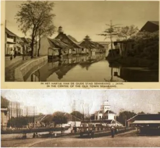
The results of the hand-drawn sketch capture the image of the city in which the Layur Mosque (early 18th century) became the landmark of the Semarang river. Whereas, in 1877, the Menara
Syahbandar/Menara Sleko (uitkijk) became the
landmarks of the new canal. The meeting point area of the two rivers marked by the presence of the Layur Tower Mosque and Sleko Tower became the city gate to Semarang at the time. The Layur Mosque once functioned as a lighthouse. Meanwhile, the Sleko Tower functioned as a small port that was equipped as a viewing tower to regulate loading and unloading of small traders and to oversee the pier and be able to view the city from the top of the tower.
Figure 2. Layur Mosque Tower at Semarang River and Syahbandar Tower at Baroe Semarang River from KITLV
C. Edges
An edge is a barrier, although sometimes there is a place to enter. It is also the end of a district if continuity is clearly visible. Likewise, the boundary function must be clear – divide or unite [1].
At the Semarang river estuary, there could be said to be something that represents an example of the multi-cultural trade city in Southeast Asia, which was formed from power-trading activities among Javanese, Malay, Chinese, and Arabic [39]. They were migrants who traded (trading partners) before the arrival of the Dutch in the early 17th century [27], [40], [41]. By using the visual image, the characteristics of various architectural buildings’ heritage are spread along the river, such as the Banjar community, Javanese house, Arab house, Chinese house, Indis house, and Melayu house [49]. Ethnic Arabs and Chinese dominate trade activities. This can be seen from the architecture of the building in the main corridor of the Melayu village [27],
5
[28]. It can be concluded that Semarang river estuary has a multi-ethnic merchant character.
Figure 3. The multi-ethnic community in the Old Semarang River (yellow area) on a map in 1719 [46], [47]
Buildings along the new canal are more dominated by warehouse buildings and sugar factories. Sugar was an essential commodity for the Dutch East Indies in the 19th century. At that time, Java was the largest sugar producer in the world. Based on this data, Muara Kali Baroe had the character of a city image of Dutch Commerce [48].
The livelihood of warehouses in the port of Semarang affected the tax revenue obtained from Semarang in 1677, which exceeded the acquisition of several ports in the vicinity, because, in the 1900s, the production of sugar was very promising, especially with the Dutch government supporting the production of sugar [42]. Along the new canal, headed to the port, there was a rapid increase in business activities and sugar trading in the 1870s [43]. One of the most prominent sugar business leaders is Oei Tiong Ham, who is famous for the nickname "Sugar King of Java" [44]. In the years of his success, between 1850-1900, the role of the new
canal was significant for the distribution of sugar. It can be concluded that the new canal was brought by Dutch trading companies. However, the new canal also provided transportation for local traders, for example, the Tasripien Concern Company, which sends its commodities, especially leather, to various destinations [45].
Figure 4. Atlas of the construction of the railroad in Semarang as the first train in Indonesia and the Row of
Buildings at Kali Baru [46], [47]
D. Node and District
Nodes are points, strategic spots in a city where an observer can enter and which is the focus for his destination [1].
Districts a two-dimensional urban areas with a medium-to-large city scale, where humans feel 'in' and 'out' from a region with generally different characteristics [1]. The characteristics that determine districts are thematic continuities which may consist of an endless variety of components [1].
In the Dutch colonial era, urban planning played an essential role in creating the existence of colonial power at that time. Their power is shown by hiding the existence the districts of the
Malay village and local government in their old
map. The city design that consists of the square, mosque, and Kanjengan are almost not visible on the map design except on the map from 1917.
Figure 6. Industrial estate and warehousing according to old map 1917
The presence of the Malay villages since the 14th century, the local government in the 15th century, and the colonial government in the old fortress town of the 17th century formed a triangle district connected to two Semarang river estuaries.
The Dutch colonial government set the Dutch fortress at the meeting point of the two estuaries of the Semarang river and the new canal. The fortress area becomes a node. The area of this node becomes the gateway to the Dutch colonial fortress to and from the harbor. The name of gateway area is Sleko, means the city gate. The area characterized by the presence of tower Sleko.
E. The Golden Cape
The symptom of coastal geological disaster always occurred until today. The sedimentation process, causes the siltation of the Semarang river estuary (Krisprantono, 2013; Supriyono, 2007) and continues until the Semarang city government built and developed the Tanjung Emas Port in Semarang in 1982.
Apparently, it was not wrong to give the name of the golden cape because Semarang had a glory from the port of Mataram era, Cheng Ho's
landing period, the pre-colonial period, and the colonial period.
IV. C
ONCLUSIONUsing the hand-drawn sketch, it can be concluded that:
1. The driving force of economic activity in the port in old river estuary is the local economy and multiple ethnic traders. This can be seen from the presence of the architectural building heritages that indicate multiple ethnic ties [1].
2. The architectural building heritage in the new canal estuary indicates the commercial offices, warehouses, and train stations that connect the port with the interior area in Java, making the image of the estuary area as the center of Dutch commerce.
The hand-drawn sketch of the glory of the city in the past displays the image by giving emphasis to the desired area and obscuring the less dominant picture [24]. A hand-drawn sketch of the city is worth more than a thousand words. The city images are often the language that captures messages and meanings, compared to written and spoken languages [25].
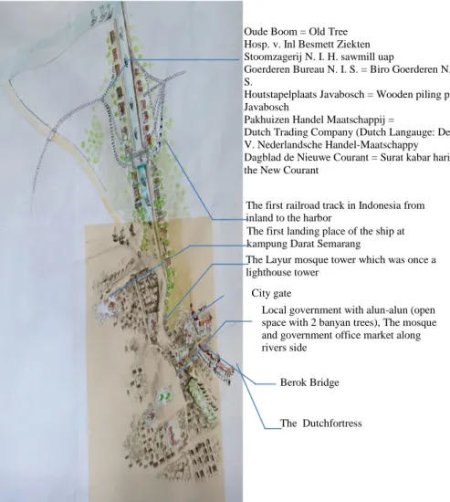
The first landing place of the ship at kampung Darat Semarang
Local government with alun-alun (open space with 2 banyan trees), The mosque and government office market along rivers side
Oude Boom = Old Tree Hosp. v. Inl Besmett Ziekten Stoomzagerij N. I. H. sawmill uap
Goerderen Bureau N. I. S. = Biro Goerderen N. I. S.
Houtstapelplaats Javabosch = Wooden piling place Javabosch
Pakhuizen Handel Maatschappij =
Dutch Trading Company (Dutch Langauge: De N. V. Nederlandsche Handel-Maatschappy Dagblad de Nieuwe Courant = Surat kabar harian the New Courant
The first railroad track in Indonesia from inland to the harbor
The Layur mosque tower which was once a lighthouse tower
Berok Bridge
The Dutchfortress City gate
7
Using the image of the city theory, the Layur Mosque Tower was found as the landmark of the old river estuary. The Syahbandar (the head of port) Tower at the new canal estuary (Kali
Baroe) and the sugar warehouses owned by Oei Tiong Ham (one of the Asian conglomerates of
his era) shape the image of the new canal. The meeting point of the two estuaries becomes a node with the nickname Sleko (Dutch), which means the city gate. The image of the glory of Semarang is lost due to the problem of land subsidence. Urban planning in the past, based on the river as transportation, resulted in the architecture and spatial structure of the Semarang city had an identity as a multi-ethnic port city (14th century) and 17th-century industrial port city. Understanding the problems, opportunities, and use of city planning in the past, [38] will allow us to plan for urban planning in the future.
A
CKNOWLEDGMENTResearchers would like to thank the research and community service institutions of Universitas Diponegoro, and the Ministry of Research and Technology for providing grants for Higher Education Applied Research in 2019 No. 101-138 / UN7.P4.3 / PP 2019. The output of the research also for strengthening collaboration research between Indonesia (DIKTI) and Netherland (NWO-WORTO) in 2019-2021 with grant No.257-91/UN7P4.3/PP/2019. Researchers would like to thank the Semarang City Spatial Planning Office and the Central Java Marine Service for providing data assistance on Semarang river activities.
R
EFERENCES[1]
“De
locomotief:
Samarangsch
Handels- en advertentie-blad,”
Feb-1869.
[2]
D. Lombard, Nusa Jawa Silang
Budaya. Gramedia Pustaka Utama,
2005.
[3]
Kuntowijoyo, Metodologi Sejarah.
Tiara Wacana Yogya, 1994.
[4]
D. Susanto, “Tradisi Seni Lisan
Sebagai Strategi Dakwah di Kalangan
Kaum
Habib
(Studi
Kasus
di
Kampung Melayu Kota Semarang).”
Fakultas Dakwah dan Komunikasi
IAIN Walisongo Semarang, 2014.
[5]
R. S. Rukayah, D. R. Puguh, and
Endang Sri Susilo, “Local Wisdom of
The Native Settlement as A Main Gate
in The Northern Axis of Javanese City
Center In Semarang Local Wisdom of
The Native Settlement as A Main Gate
in The Northern Axis of Javanese City
Center In Semarang,” 2018.
[6]
R. S. Rukayah, E. S. Susilo, M.
Abdullah, and S. Saputro, “Exploring
The Position Of Old Semarang Sea
Port: Based on Javanese City Pattern,”
IOP Conf. Ser. Earth Environ. Sci.,
vol. 116, no. 1, pp. 0–8, 2018.
[7]
R. Rukayah, D. R. Puguh, E. S. Susilo,
and M. S. Indraswara, “Local Wisdom
of the Native Settlement as A Main
Gate in the Northern Axis of Javanese
City Center in Semarang,” IOP Conf.
Ser. Earth Environ. Sci., vol. 152, no.
1, 2018.
[8]
S. Wibowo, “Sejarah Perkembangan
Kota Semarang ( Jawa Tengah ) di
Masa Lalu dan Dampak Kehadiran
Polutan Nitrat Pada Airtanah di Masa
Kini History of the past development
of the Semarang city ( Central Java )
and its impact on nitrat pollutants
presence in the ground,” Ris. Geol.
dan Pertamb., vol. 23, no. 1, pp. 25–
36, 2013.
参考文:
[1] 林奇(K. LYNCH)(1960 年)《城市
形象》,第 1 期。 11.马萨诸塞州剑桥:
麻省理工学院出版社。
[2] FILOMENA,G.,VERSTEGEN,J.A.,
MANLEY,E. 和 LYNCH,K.(2019)一
种计算方法,用于“城市形象”。城市,89,
第 14-25 页。
[3] SARAH , D. 和
SOEBOWO , E.
(2018)爪哇岛北海岸的地面沉降威胁及
其管理。眼压会议系列:地球与环境科学,
118 (1),012042。
[4] REEDER-MYERS,L.A.(2015)二十
一世纪的文化遗产面临风险:美国沿海考
古遗址的脆弱性评估。岛与海岸考古学报,
10,第 436-445 页。
[5] Z. RAMLI 和 N.H.S.N.A. RAHMAN。
(2009)交易商交易活动在阿拉伯 - 波斯
马来半岛据国外资料和考古资料。莎莉
( 莎 丽 ) : 《 法 律 杂 志 》 , 27 (2), 第
147-165 页。
[6] WAHBY,A.E.I。(2007)爪哇早期
清真寺和神社的建筑:15 和 16 世纪阿拉
伯商人的影响?论文,班贝格大学。
[7] VAN BEMMELEN,R.(1949)印度
尼西亚地质。海牙:V.F.A.政府印刷局。
[8] COLBRAN,N.(2009)雅加达会成为
下一个亚特兰蒂斯吗?自来水管网失灵导
致地下水过多使用。 5/1 法律,《环境发
展杂志》,5,第 20-37 页。
[9] HADI,S.P.(2017)寻求可持续的沿
海管理:印度尼西亚三宝垄的案例研究。
眼压会议系列:地球与环境科学,55,
012054。
[10] GUMILAR , M. , ABIDIN , I. ,
SIDIQ , H.Z. , ANDREAS , T.P. ,
MAIYUDI,H. 和 GAMAL,R.(2013)
绘制和评估三宝垄(印度尼西亚)土地沉
降的影响。印度尼西亚地理空间杂志,2
(2),第 26-41 页。
[11] KUEHN , F. , ALBIOL , D.D. ,
COOKSLEY
,
G.G.
和
MURDOHARDONO , A.H.D.
D. 。
(2010)使用稳定点网络(SPN)技术检
测印度尼西亚三宝垄的地面沉降。环境地
球科学,60,第 909-921 页。
[12] E. CHAUSSARD,F。AMELUNG 和
H.Z. ABIDIN 。 ( 2012 ) 印 尼 的 沉 没 城
市:土地沉降速率和空间分布的空间大地
证 据。 在 : 《艺穗节 2011 研讨会论文
集》,弗拉斯卡蒂,2011 年 9 月,第
19-23 页。
[13] CORTESAO,A。(1944 年)东方之
书的一些东方:从红海到日本的东方记述,
于 1512 年至 1515 年在马六甲和印度发表。
伦敦:哈克卢伊特社会丛刊。
[14] MAZIYAH,S。(2012)八世纪至十
五世 纪中 爪哇 的状况 中号. 曼尼卡 ,15
(
9
)
。
可
从
https://ejournal.undip.ac.id/index.php/humani
ka/article/view/3999 获取。
[15] JOE,L.T. (1933)三宝垄历史:从
他的三宝桑佩到孔古安。三宝垄:何金
Yo 书店。
[16] YUANZI,K.(2000)成浩·穆斯林·
廷加。群岛旅行的奥秘。雅加达:亚亚桑
·普斯塔卡·奥博尔印度尼西亚。
[17] TIO,J.(2004 年)哥打三宝垄达兰·
克南甘。三宝垄
[18] RUKAYAH , R. , PUGUH , D.R. ,
SUSILO , E.S. 和 INDRASWARA, M.S.
(2018)在三宝垄的爪哇市中心北轴作为
本地大门的本地居民的当地智慧。眼压会
议系列:地球与环境科学,152(1),
012032。
[19] RUKAYAH,R.S.,SUSILO,E.S.,
ABDULLAH , M. 和
SAPUTRO , S.
(2018)探索三宝垄旧港口的位置:基于
爪哇城市模式。眼压会议系列:地球与环
境科学,116(1),012036。
[20] RUKAYAH,R.S.,SUSILO,E.S. 和
ABDULLAH,M.(2018)三宝垄·哥打佩
西西尔喇嘛。日惹:泰克诺·塞恩。
[21] 机车:萨马兰奇商业和广告 杂志。
(1869 年)三宝垄。
[22] PRIHATMOKO,H.(2014 年)《达
西航空达拉姆·帕达冈甘·帕达·马萨·贾瓦·
库 纳迪
·贾瓦·蒂穆尔》。考古论坛,27
(3),第 155-174 页。
[23] ANDRISIJANTI,I。(2015)政府中
心样机开发。 1(1),第 1-29 页。
[24] DEVANNY,S.(2010)手绘草图在
莱昂纳多·达·芬奇与弗兰克·盖里的素描
之间的比较研究建筑师行业中的作用。印
度尼西亚大学。
[25] POLE,C。(2004)眼见为实?视觉
研究方法。贾出版社。
[26] SUSANTO,D。(2014 年)口头艺
术传统,社会上的大瓦战略,哈比布·卡
苏斯案例研究,甘榜,三宝垄市马来语)。
IAIN Walisongo 三宝垄的大华与传播学院。
[27] MADIASWORO,T。(2009 年)振
兴甘榜美拉宇三宝垄的当地智慧价值观。
地方智慧,1,第 10-18 页。
[28] WIBAWA,S.(2013)三宝垄市(中
爪哇省)过去的发展历史及其对当今地下
水中硝酸盐污染物存在的影响。印尼地质
与采矿杂志,23(1),第 25-36 页。
9
![Figure 3. The multi-ethnic community in the Old Semarang River (yellow area) on a map in 1719 [46], [47]](https://thumb-ap.123doks.com/thumbv2/123deta/8047517.1255200/5.892.120.455.124.655/figure-multi-ethnic-community-old-semarang-river-yellow.webp)