トップページ - 横浜国立大学学術情報リポジトリ
24
0
0
全文
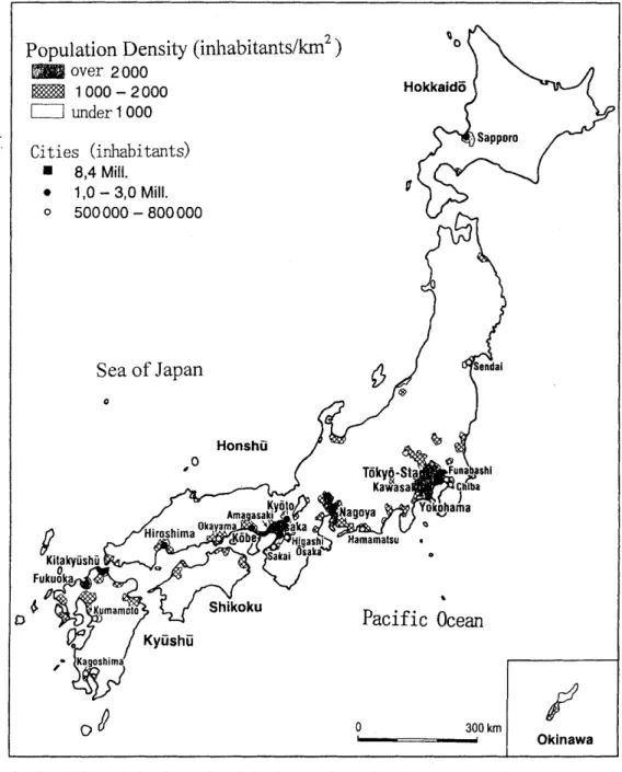
(2) 1. Introduction Nature conservation in cities has advanced in the last decades in many industrial countries, connected with the rapidly increasing urban population (e. g. Adams & Leedy 1988, Goode 1989, Muller 1997, Sukopp 1990, Sukopp & Sukopp 1987, Sukopp & Werner 1982, 1988). Nature conservation in cities focuses on the conservation of a t least a minimum number of plants and animals, and their habitats (biotopes). These should be conserved a s a basis for direct contact between urban dwellers and the natural elements of their surroundings, and in order to preserve biodiversity, and to improve the quality of the environmental media: air, water and soil. The growing concern for urban nature is illustrated by the "Green Paper on the Urban Environment" published by the European Community (19901, which stresses the importance of nature conservation in cities. In Germany, for example, a special law for nature conservation demands that nature be conserved, maintained and developed in populated areas as well a s in unpopulated areas. In the 1970s, investigations started in Germany in order to take inventory of the habitats of flora and fauna which are important for nature conservation in cities (Starfinger & Sukopp 1994, Sukopp & Weiler 1988). The investigations, which became famous a s "biotope mapping", focus mainly on floristic and phytosociological features. Additionally, some animal populations are studied (cf. Miiller 1997). In general "biotope mapping" involves the investigation of plants and animals, their habitats (biotopes) and the assessment for nature conservation. In contrast to most European countries, where biotope mapping is an important basis for nature conservation, similar standardised investigation methods so far do not exist in Japan. There-, fore, in the urban agglomeration of Tokyo-Yokohama, a pilot study was started in the summer of 1996 in order to test this method in Japan. The background for this study and general features of urban habitats and methods of biotope mapping were explained in a recently published paper (Miiller 1997). Methods and first results of * the pilot study are presented in this publication, along with recommendations for the future.. 2. General Features of Japanese Cities Japan is among the most densely populated countries of the world. In general, the archipelago is characterised by a high concentration of the population in cities, which are mainly situated on flat areas along the coastline. In the year 1990, 59% of the total population lived in cities (more than 100,000 inhabitants) and 21% in cities with more than one million inhabitants (Fluchter 1994). There are 10 cities with more than 1 million people and 21 cities with more than 0,5 Mill. inhabitants. The main urban agglomerations concentrate around Tokyo, Nagoya and Osaka, where more than 2000 inhabitants per square km are living (Fig. 1). In general, the few flat areas along the coast are populated densely, whereas the hilly and mountainous areas remain unsettled or have a low population density. The fast growth of settlements after the industrial period is typical in Japan. Besides the expansion of settlements in the open landscape, the reclamation of new land along the coast is typical. In order to satisfy the high demand for land in Tokyo Bay, The sea is filled with soil and rubbish to create new areas for settlement and industry. Due to fast growth in this century and the high frequency of disasters such a s earthquakes, and subsequent fires, there are few old settlements and old green spaces in Japanese cities compared with European. An exception and particular characteristics of Japan are Shinto shrines.
(3) 0under 1000 Cities (inhabitants) 0. 8,4 Mill. 1,O - 3,O Mill. 500 000 - 800 000. Sea of Japan 0. Pacific Ocean. 0. 1. 0. 300 km. Quelle: 1985 Population Census Population Maps of Japan, Part 2, Nr. 2; Population Density by Shi, Machi and Mura. Bearbeitung: W. Fliichter Fig. 1 Population density of Japan (from Fliichter 1994). and Buddhist temples, where the woody vegetation has remained untouched since ancient times. Therefore relics of old forests can often be found (e. g. Miyawaki et al. 1980, Okuda 1972). Typical for urban habitats is the high number of alien plants, which have their origin mainly in Europe and North America (Asai 1993)..
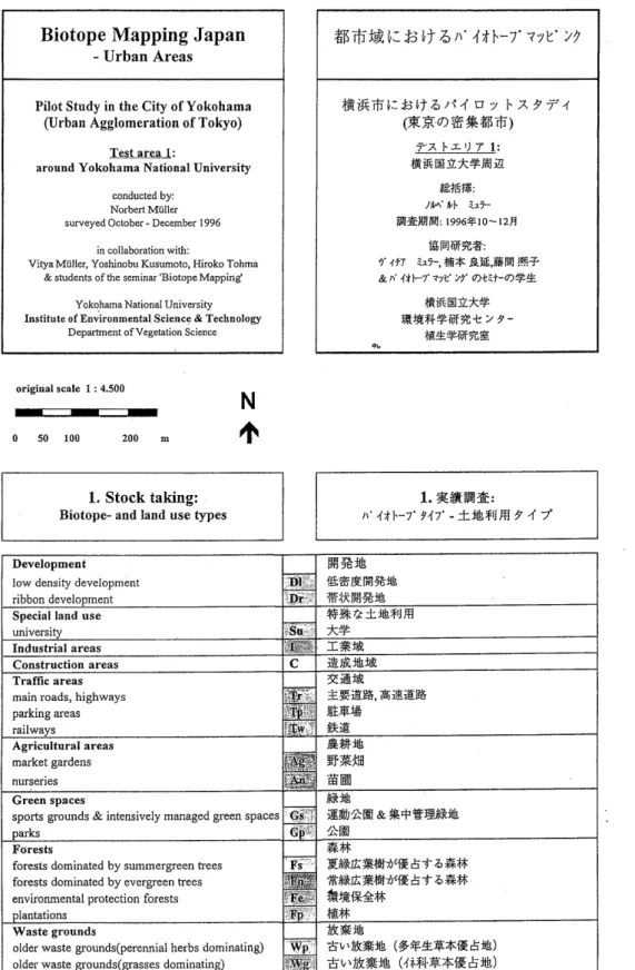
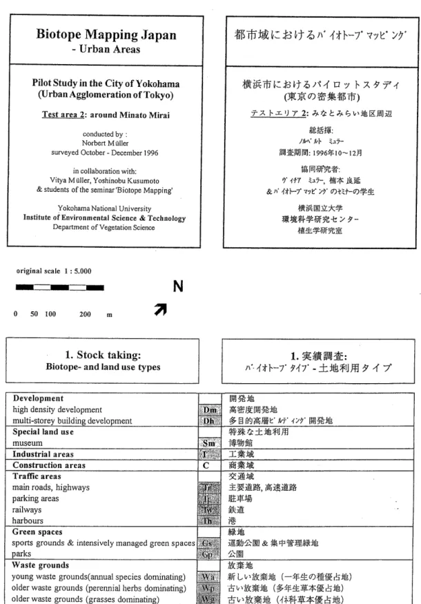
(4) 3. Methods In order to test the European method for biotope mapping in a short time and with a small staff, the pilot study in the urban agglomeration of Tokyo was done a t only two test areas in Yokohama City. A modified method for the representative mapping was used for the investigation. After investigation of the land-use types and after checking the biologically rich areas, a n evaluation was done. In this way, only areas worthy of protection were selected. A demohstration of all areas which are important for nature conservation (e. g. special land-use types which are important a s corridors in the city) was not possible, due to the small size of the test areas.. 3 . 1 Selection of the test areas Many investigations in cities have shown (e. g. Gilbert 1991) that the land-use types are homogeneous habitats for flora, vegetation and wildlife. The test areas were selected in such a way that many typical land-use types of the urban agglomeration of Tokyo would be represented. Investigations were done: a ) around the campus of Yokohama National University - test area 1; b) around Minato Mirai. -. test area 2.. 3 . 2 Checking of the available biological data Actual data of flora and vegetation exist for parts of test area 1, the campus of Yokohama National University (Okuda 1994, Thoma et al. 1994). Further basic information sources include old and actual vegetation maps of Yokohama City (Miyawaki et al. 1972, Yokohama City 1993).. 3 . 3 Mapping of the land-use types The land-use types were marked and controlled by field investigations on the basis of aerial photos a t the scale 1: 4000. In this way, the biologically rich areas were marked, i. e. areas with a high amount of spontaneous vegetation and low human impact, e. g. green spaces, abandoned land, forests and plantations, agricultural areas, special land-use types with a high amount of green space and low-density development. They were investigated in more detail in the next step.. 3 . 4 Checking the biologically rich areas and evaluation of biotopes worthy of protection By field investigation, representative samples of fldra and vegetation of the biologically rich areas were investigated. Releves from typical plant communities and lists of the dominating vascul a r plants were compiled. Afterwards, the areas worthy of protection were selected and described with standardised forms. The fundamental parameters for all sites were: -. Reproducibility and age of the site - areas which are replaceable in the long or medium term (at least 3. -. 4 years) were mapped.. - Size - for the selection of a biologically rich area the minimum size was in general 0.2 ha. Additionally, at least one of the following parameters was necessary for selection a s a biotope worthy of protection: - Spontaneous occurrence of the site -. -. areas with a typical spectrum of spontaneous species;. Structural variety of the site - areas with a high variety of vegetation types and age (e. g. green spaces with different vegetation types, such a s lawns, shrubs and plantations);. - Rarity of a site and of the spontaneous species. -. areas which are rare or contain rare species. in settlements (e. g. wetlands and natural forests)..
(5) 3 . 5 Summarising the data and displaying the results After the field investigations maps were drawn at the scale 1: 5000 from the a) land-use types, b) biotopes - biologically rich and worthy of protection. The biotopes worthy of protection were summarised on standardised forms with a short description of the biotope, the characteristic and dominant plants and special suggestions for further management, etc. (cf Table 1). Finally, a list with a short description of the biotopes worthy of protection was made.. 4. Areas Studies and Land-use Types 4.1 Test area 1 - around the campus of the Yokohama National University The test area is situated west of the centre of Yokohama and characterised by a hilly morphology (Fig. 2). The potential natural vegetation of the area is evergreen forest (Quercetum myrsinaefoliae) (Miyawaki et al. 1972). Today, low-density development with many private gardens dominates the test area (Fig. 2). The southern part includes the campus of Yokohama National University (mapped a s special land-use type "universityJ'). The university was founded on a hill in the year 1949. Today the area includes vacant land a t different ages due to the initial reservation of larger areas for the further development of the university. The high number of secondary forests, which is almost 50 years old, is remarkable. The forests remain on steep hills a s relics of the former land-use. The forests have been cut regularly in order to get firewood. Larger agricultural areas are situated in the northern part of the test area. Mainly vegetables such a s cabbage are cultivated here. Also larger areas for traffic can be found here, such a s a goods depot and a highway. Larger vacant and/or abandoned areas are situated on the University campus and in the agricultural area.. 4.2 Test area 2. - around Minato Mirai. The area embraces the old port of Yokohama. -. the leading international port in Japan, which. was opened in the year 1859. The potential natural vegetation of the area is evergreen forest (Polysticho-Perseetum thunbergii) (Miyawaki et al. 1972). Today the flat area along the sea is settled densely with a high concentration of buildings (Fig. 3). Dominant land-use types are high-density development, areas for traffic (main roads, parking areas) and multi-storey building development. Along the coastline are industrial areas. All these land-use types show high paved areas. Larger unpaved areas with waste grounds can be found only along the railways. There are three large public parks and several smaller intensively managed public green spaces mainly along the coast. A particularity of the test area is reclaimed land. It can be found along all of Tokyo bay (cf Miyawaki et al. 1975). New areas for settlements are created by filling up the sea with soil and other deposits. In the test area, a modern city (Minato Mirai 21) is in development on filled land. New multi-storey buildings are dominant here beside younger vacant land for further development.. 5. Biotopes Worthy of Protection In this chapter the biotopes worthy of protection are described briefly, by their vegetation and their characteristic species. A short description of all biotopes appears in the appendix (Table 2 and 3). More detailed information about plant communities can be found in Tohma et al. 1994.
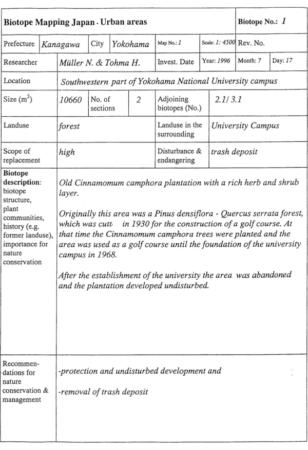
(6) Table 1 Example of a form for a biotope worthy of protection. I. IBiotope Mapping Japan - Urban areas Prefecture Kanagawa. 1. City. Yokohama. Biotope No.: 1. Map NO.:1. Scale: 1: 4500. Rev. No.. Invest. Date. Year: 1996. lvlonth: 7. Day: 17. Researcher. MGller N. & Tohma H.. Location. ( Southwestern.part of Yokohama National University campus. Size (m2). 10660 No. of sections. .. 2. Adjoining biotopes (No.). 2.11 3.1. Landuse. forest. Landuse in the surrounding. University Campus. Scope of replacement. high. Disturbance & endangering. trash deposit. Biotope description: biotope structure, plant communities, history (e.g. former landuse), importance for nature conservation. Old Cinnamomum camphora plantation with a rich herb and shrub layer. Originally this area was a Pinus densipora - Quercus serrata forest, which was cuttl in 1930 for the construction of a golf course. At that time the Cinnamomum camphora trees were planted and the area was used as a golf course until the foundation of the university campus in 1968. After the establishment of the university the area was abandoned and the plantation developed undisturbed.. Recommen-protection and undisturbed development and dations for nature ~ ~ ~ ~ ~ r v&a t -removal ion of trash deposit management.
(7) Cinnamomum camphora. Hedera rhombea ~ i ~ u s t r ujaponicum m Nandina domestica. Houttuynia cordata Ophiopogon ohwii. a, S.1994: Flora of Yokohaina National University, Tokiwadia Cai?zpus.Bull. Inst. Environ. cLence & Techn. Yokohama National University 20: 147-159 Tohma, H., Ishii, S. & Fujiwara, K 1994: Actual vegetation in tlze Yokohama National University Campus - Vegetation change over 25 years. Bull. Inst. Environ. Science & Techn. Yokohama. Prof: Dr. K Fujiwara, H. Tohma & Pri$ Dr. S. Okuda, Yokohama National University Institute Environmental. Science &.
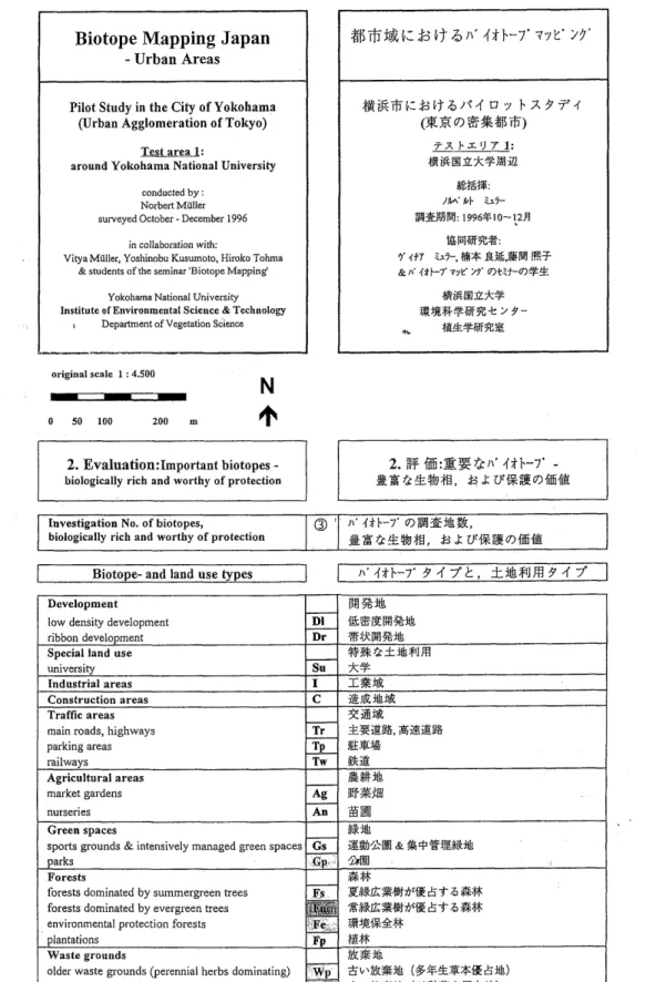
(8) Biotope Mapping Japan. %b*igb:. $3 k f. 6 )I* 4%b-7a ?7t029. - Urban Areas Pilot Study in the City of Yokohama (Urban Agglomeration of Tokyo). @i&*C~;rjlb-f&lf4 17 7 ~~~~4. (3ES.aB%%R*) P'X. Test area 1: around Yokohama National University. E%f;)$:. conducted by: Norbert Muller surveyed October - December 1996 in collaboration with: VityaMiiller, Yoshinobu Kusumoto, Hiroko Tohma & students of the seminar 'Biotope Mapping'. ~ J I - ' J7 1:. %%H~A+Jaiz /~h/\' kb <zj-. 1%%k!: 1996q10-12fi. tXIAHifFR2: 3' 4-f7 <15-, U$ hZ,Ik!!%3 & 1)' 4tb-7' wC' 73' a+< +-a?&. @i&HG%%. Yokohama National University Institute of Environmental Science & Technology Department of Vegetation Science. %%?+Y@F%-k 2 9-. ~B&%H%% 4C. original scale 1 : 4.500. 1. Stock taking: Biotope- and land use types. low density development. & intensively managed green spaces. forests dominated by evergreen trees environmental protection forests. Fig. 2 Land-use types of test area 1.
(9)
(10)
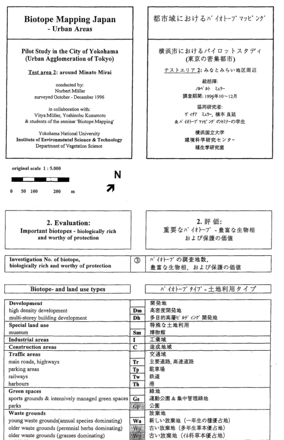
(11) Biotope Mapping Japan. - Urban Areas. Pilot Study in the City of Yokohama (Urban Agglomeration of Tokyo) Test area 2: around Minato Mirai conducted by : Norbert M iiller surveyed October - December 1996 in collaborationwith: Vitya M iiller, Yoshinobu Kusumoto & students of the seminar 'Biosope Mapping' Yokohama National University Institute of Environmental Science & Technology Department of Vegetation Science. original scale 1 :5.000. N. I 0. 50 100. 200. 3. m. 1. Stock taking: Biotope- and land use types. Fig. 3 Land-use types of test a r e a 2.
(12)
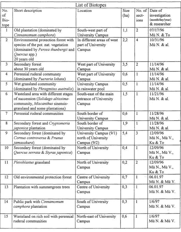
(13) Table 2 Short description of the biotopes worthy of protection in test area 1. Arround Yokohama National University. List of Biotopes No. of Biotope 1 2. 3 4. 5 6. 7 8. 9. 10. Short description. Location. Size (ha). Old plantation (dominated by Cinnamomum camphors) Environmental protection forest with species of the pot, nat. vegetation (dominated by Persea thunbergri and Quercus spp.) 20 years old Secondary forest about 30 years old Perennial ruderal commumty (dominated by Pueraria lobata) Wet grassland community (dominated by Phraginites australis) Wasteland area with different stages of succession (Solzdago altissimacommunity, Miscanthus sinensisgrassland and some plantations) Perennial ruderal communities. South-west part of University Catnpus In different areas of west part of University Campus. 1,l. Secondary forest and Cryptonzeria japonica plantation Secondary forest (dominated by Cornus controversa & Prunus jamasakura) Secondary forest (dominated by Quercus serrata & Styrax japonica). West part of University Campus West part of University Campus University Campus in rainwater pool South-east of the main entrance of University Campus. 2,2. No. of Date of sect- investigation (month/day/year) ions & researcher 07/17/96 2 Mu N. & To 1013 1/96 4 Mii N. & al.. 3,5. 2. 0,6. 1. 0,5. 1. 1,5. 1. South border of 0,6 University Campus South border of 1,9 University Campus University Campus (911) 5,4 north of University Campus (912) North of University 0,4 Campus. 1 1 3. 1. 11/14/96 Mu N. & al. 11/14/96 Mu N. & al. 11/14/96 Mu N. & al. 11/21/96 Mu N. & al.. 11/28/96 Mii N. & al. 11/28/96 Mu N. & al. 12/09/96 MuN., Mu V., Ku & To 12/0 9/96 Mu N., Mu V., Ku & To 12/09/96 Mu N., Mu V., Ku & To 06.01.97 Mu N. & Mu V. 06.01.97 Mu N. & Mii V.. 11. Plezoblastus grassland. North of University Campus. 0,2. 2. 12. Old environmental protection +rest. 0,7. 1. 13. Plantation with summergreen trees. Centre of University Campus Centre of University Catnpus. 0,3. 1. 14. Public park with Cinnamonzum camphora plantation. 0,3. 1. 1/6/97 Mu N. & Mu V.. 15. Wasteland on rich soil with perennial North-east of University ruderal communities Campus. 0,6. 1. 1/6/97 Mu N. & Mu V.. South of University Campus. B.
(14) 16. Remnant of old plantation (dominated by Cyptomer~a japonzca). 17. M~scanthusgrassland. 18. 19 20 21. 22 23 c9. 24 25 26. 0,2. 2. 12116/96 Mu V. & To. 0,5. 3. 06.01.97 Mu N. & Mu V.. 0,7. 2. 06.01.97 Mu N. & Mu V.. 0,6. 1. 0,4. 1. 2,4. 1. 12116/96 Mu V. & To 12116/96 Mu V. & To 06.01.97 Mu N. & Mu V.. 0,7. 1. 1,6. 1. 1,3. 1. 1,2. 4. 0,3. 1. 0,7. 2. Railway area north of University Campus. 0,2. 1. Highway and railway embankment north of University Campus North of University Campus. 0,7. 2. East of University Campus. North-west of University Campus at highway embankment Secondary forest North-west of University Campus along the highway Public park with Prunus yedoensis East of University plantation Campus Secondary forest (dominated by East of University Quercus serrata) Campus Sec~ndaryforest North-east of University Campus west of highway M~scanthusgrassland north of University Campus Secondary forest North of University Campus Pleroblastus grassland & remnant of North of University secondary forest Campus Secondary forest North of University Campus Old plantation with swnlnergreen North of University trees Campus. 27. Pleioblastus grassland with remnants North of University Campus of secondary forest. 28. 29. Annual and perennial ruderal communities on rough gravel (dry and wet sites) Miscanthus grassland. 30. Secondary forest. 31. Old private park. North of University Campus. 0,5. 1. 32. Secondary forest along a highway. North east of University Campus. 1,2. 2. 1. 06.0 1.97 Mu N. & Mu V. 12119/96 Mu N. & al. 12/19/96 Mu N. & al. 12119/96 Mu N. & al. 0 1/07/97 Mu N., Mu V. & Ku 0 1/07/97 Mu N., Mu V. & Ku 0 1/07/97 Mu N., Mii V. & Ku 0 1/07/97 Mii N., Mu V. & Ku 0 1/07/97 Mu N., Mii V. & Ku 0 1/07/97 Mu N., Mu V. & Ku 1/20/1997 Mii N. & Mu V.. Abbreviations: Mu N.= Miiller, N., To = Tohrna H., Mu V. = Miiller V., Ku = Kusomoto, Y..
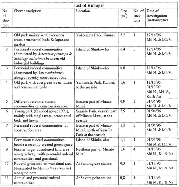
(15) Table 3 Short description of the biotopes worthy of protection in test a r e a 2. Arround Minato Mirai.. List of Biotopes No. of Biotope 1. 2 '. 3. 4. 5. 6. 7. 8. 9. 10. 11. Short description. Location. Size (m2). No. of Date of sect- investigation (mortth/day/year) ions. Old park mainly with evergreen trees, ornamental beds & Japanese garden Perennial ruderal coimnunities (dominated by Artenzisiaprinceps & Solidago altissima) between old industrial buildings Perennial ruderal communities (dominated by Aster subulatus) along a recently constructed road Old park with evergreen trees, lawns and ornamental beds. Yokohama Park, Kannai. 3,2. 1. 1,2114/96 Mu N. & Mu V.. Island of Shinko-cho. 0,4. 3. 12/14/96 Mu N. & Mu V.. Island of Shmko-cho. 0,8. 2. 12/14/96 Mu N. & Mu V.. Yamaslita Park, Kannai, at the seaside. 1,6. 1. Eastern part of Minato 0,9 Mirai Seaside Park, eastern part 3,9 of Minato Mirai, at the seaside Eastern part of Minato 1,3 Mirai, north of Seaside Park at the seaside Island of Shinko-cho 1,l. 5. 12/15/96, 01/13/97 Mii N., Mu V., Ku & Na 0 1/04/96 Mu N. & Mu V. 0 1/04/96 Mu N. & Mu V.. Different perennial ruderal coimnunities on construction area Young park (founded about 1993), mainly with single trees, ornamental beds and lawns Perennial ruderal communities, on construction area Pennanent ruderal colmnunities beside a recently created green space Former larger abandoned land area along railway, with perennial ruderal communities and grasslands Ruderal grassland on wasteland area (dominated by Miscanthus sinensis) along the port Annual and perennial ruderal communities. 1. 2. 0 1/04/96 Mu N. & Mu V.. 1. 0 1/04/96 Mu N. & Mu V. 01/13/96 MuN., Ku & Na. Northern part of Minato Mirai. 1,6. 4. At Sakuragicho station. 0,3. 1. 01/13/96 Mu N., Ku & Na. At Sakuragicho station. 0,8. 1. 0 1/16/96 Mu N., Ku & Na. Abbreviations: Mu N.= Miiller, N., Mu V. = Muller V., Ku = Kusomoto Y., Na = Nagaoka F.. d.
(16) (campus of Yokohama National University), in Miyawaki et al. (1972) and Yokohama City (1993) (vegetation of Yokohama). A flora of the campus of Yokohama National University was published by Okuda (1994).. 5.1 Test area 1. - around the campus of the Yokohama National University (Fig. 4). Almost 18 % of the test area was covered with secondary forests (Prunus jamasakura. -. Cornus. controversa community). Characteristic species are summergreen trees, such a s Prunus jamasakura a n d Cornus controversa. In the dense shrub layer, the main species are Aucuba japonica and. Fatsia japonica. Pleioblastus chino often dominates in the herb layer. A relict of a primary forest with evergreen trees (Ardisio-Castanopsietum sieboldii) remains in the centre of the University campus. Many environmental protection forests were planted in the campus area 20 years ago. Evergreen trees (Persea thunbergii, Quercus div. spec., Castanopsis cuspidata var. sieboldii, etc.) of the potential natural vegetation were used for these plantations. Since then, many native species of shrubs and herbs of the evergreen forest have invaded. Some old plantations (mainly with Cinnamomum camphora) were mapped a s biotopes worthy of protection due to their natur a l herb and shrub layers. In grass-dominated old abandoned areas Miscanthus sinensis and. Pleioblastus chino form a dense layer. An earlier stage of succession on vacant areas is dominated by perennial herbs. Due to human impact and the nutrient conditions in the soil, different plant. communities have. arisen. Dominant communities with the native. pioneer. species. B. Polygonum cuspidatum or the alien species Solidago altissima are common on episodically disturbed areas. Many alien species (e. g. Aster subulatus, Oenothera biennis) are also characteristic for dry sites along the railway area. On fresh and nutrient-rich sites, liana communities with. Pueraria lobata are characteristic. 5.2 Test area 2. - around Minato Mirai (Fig. 5). This area shows fewer biologically rich areas. Parks and abandoned land with herbaceous ruderal vegetation cover about 2 percent of the whole area studied. Older large parks are the Yokohama P a r k and the Yamashita Park. Yamashita P a r k was founded on the area reclaimed with garbage from the Kanto Dai-Shinsai earthquake (in 1923). It is the oldest public park in Yokohama. The main plantation trees in Yokohama P a r k are Castanopsis cuspidata var. sieboldii and Zelkova serrata. In the older Yamashita Park Lithocarpus edulis and Myrica rubra are most commonly planted trees. Both green spaces are used frequently for recreation. Therefore the. Zoysia japonica lawns are partly reduced by trampling to communities with Poa annua and Taraxacum officinale. The seaside park, a young park, has until now had less spontaneous vegetation. Transplanted lawns, ornamental beds and solitary trees form this new park, constructed in the year 1994. The main planted trees are Myrica rubra, Cinnamomum camphora and Pinus thunbergii. Different old abandoned areas, situated mainly on reclaimed land, were studied a s biotopes worthy of protection. In general these are remnants of former larger abandoned areas which are now under construction o r already settled. The main species of the herbaceous ruderal vegetation are Artemisia. princeps, Oenothera biennis, Bidens pilosa and Solidago altissima. On younger sites Aster subulatus is dominant. Tree seedlings of Cinnamomum camphora, Aillanthus altissima and Celtis sinensis are frequent. Naturalized cats are conspicuous in the parks and vacant land of the Minato Mirai area.. 1.
(17) Biotope Mapping Japan - Urban Areas Pilot Study in the City of Yokohama (Urban Agglomeration of Tokyo) Test area 1: around Yokohama National University conducted by : Norbert Miiller surveyed October December 1996. -. in collaboration with: VityaMiiller, Yoshinobu Kusumoto, Hiroko Tohrna & students of the seminar 'Biotope Mapping' Yokohama National University Institute of Environmental Science & Technology Department of Vegetation science. ,. original scale 1 : 4.500. 2. Eva1uation:Important biotopes -. Investigation No. of biotopes, biologically rich and worthy of protection. I. @. Biotope- and land use types. :. 1\.4$b-7. D%&&%, &g&&%@, & k b4%%04fI4E )\..(tE-7'. 9 4 7 2 , f&;fllH94l. M%!&. Development low density development ribbon development Special land use university Industrial areas Construction areas Traffic areas main roads, highways parking areas railways Agricultural areas market gardens. Dl Dr SU I C. 1&%?7&5Efk4%& %kMl%M %%6?k&$~H. I%@. %&&&. ?zi!%i&. Tr Tp. &%?%4,&%%%. Tw. $kg. Ag. @I#% @%tm. sports grounds & intensively managed green spaces. forests dominated by summergreen trees. . .. #%li;%Rfl@ &?4 %%. -. Fig. 4 Biotopes worthy of protection in test area 1. I.
(18)
(19) Biotope Mapping Japan. - Urban Areas Pilot Study in the City of Yokohama (Urban Agglomeration of Tokyo) Test area 2: around Minato Mirai conducted by: Norbert Milller surveyed October - December 1996 in collaboration with: Vitya Miiller, Yoshinobu Kusurnoto & students of the seminar 'Biotope Mapping' Yokohama National University Institute of Environmental Science & Technology Department of Vegetation Science. original scale 1 : 5.000. 2. Evaluation:. Important biotopes - biologically rich and worthy of protection. Investigation No. of biotope, biologically rich and worthy of protection. I. Biotope- and land use types. @. I\*. 4i-b-7. a%?$%@,. &g&&%$4, &1 7.F%@a@i@. 1. 1)'. .l'%b-7' 947'. - kf&$lJH 9 4 7'. main roads, highways. older waste grounds (perennial herbs dominating) older waste grounds (grasses dominating). &b)&%N (dm-%*@. Fig. 5 Biotopes worthy of protection in test area 2. k%).
(20)
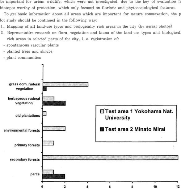
(21) 5 . 3 Summarisation The large number of biotopes worthy of protection in test area 1 is remarkable, compared with the other areas (Fig. 6). The reasons are the hilly morphology and the development of settlements recently. In contrast, test area 2 belongs to the old city of Yokohama and has been settled for a long time. Along the flat coast a high density of old settlement was possible, and therefore fewer areas remained for spontaneous nature.. 6. Continuation of the Pilot Study and Recommendations for the Future For a final evaluation for nature conservation the actual data are not enough. In test area 2, the special land-use type 'university' and the agricultural areas may be important as corridors in the city, due to their high number of small vacant areas. At the moment, an evaluation of this type is not possible, due to the limited investigation area. In the same way some areas may be important for urban wildlife, which were not investigated, due to the key of evaluation for biotopes worthy of protection, which only focused on floristic and phytosociological features. To get basic information about all areas which are important for nature conservation, the pilot study should be continued in the following way:. 1. Mapping of all land-use types and biologically rich areas in the city (by aerial photos) 2 . Representative research on flora, vegetation and fauna of the land-use types and biologically rich areas in selected parts of the city, i. e. registration of: - spontaneous vascular plants - planted trees and shrubs - plant communities. grass dom. ruderal vegetation herbaceous ruderal vegetation. old plantations. environmental forests. K l ~ e sarea t 1 Yokohama Nat. University. I I Test area 2 Minato Mirai. primary forests. secondary forests. parcs. Fig. 6 Expanse of biotope-types worthy of protection (in percent) in the two test areas, as compared to the whole area investigated (100%)..
(22) -. selected animal populations (especially species with a high value of indication for urban habitats). The following animals should be studied: birds; selected groups of mammals, e. g . bats,. shrews. and. hedgehogs;. amphibians. and. reptiles;. grasshoppers,. (Macrolepidoptera) , beetles (Carabidae) , dragonflies, spiders (Araneae). butterflies. and wild. bees. (Apoidea) (Arbeitsgruppe "Methodik der Biotopkartierung im besiedelten Bereich" 1993). 3 . Developing of specific mapping guidelines for biotopes worthy of protection and other landuse types important for nature conservation in the city (priority areas for nature conservation). 4 . Investigation of priority areas for nature conservation in the whole city area -. description of the biotopes worthy of protection, with standarized forms. -. description of the land-use types important for nature conservation in the city (such a s important corridors). 5 . Summarising the results and display on maps - m a p of biotopes worthy of protection would be important for nature conservation in the city. 6 . Development of general recommendations for management and green planning for all types from the viewpoint of nature conservation After finishing the pilot study in Yokohama, the mapping guidelines can be used for further investigation in the agglomeration of Tokyo a s well a s in other Japanese cities. The results will be available shortly, following standardised method. The advantage is that, afterwards, the results from different cities can be compared. In this way a n overview of the situation of nature in the different Japanese cities will be available. In addition to the information about National Parks in J a p a n , this will be important information for further strategies in nature conservation policy. In order to get comparable data, biotope mapping should be organised and conducted by the government.. 7. Practical Use and Application Through biotope mapping in urban areas, much biological information can be gained and summarised up in a short time. The advantage of this method is the practically orientated investigation and demonstration of the results on standard forms, with recommendations for further investigation a s well a s management and protection. After finishing the pilot study in Yokohama City and in other cities the results can be used for several purposes:. 1. Infrastructure planning, for example: - basic information for the land-use plan (e. g. where are the priority areas for nature conservation?) - fundamental information for the landscape plan (kind of conservation status for the priority areas for nature conservation, location of important corridors and their development, information for the development of the different urban land-use types with special attention to nature conservation) 2 . Programs and laws for nature conservation, for example: - programs for endangered species - fundamental information for the development of laws (e.g. for the protection of trees in cities) 3 . Recommendations for nature management of the land-use types --especially green spaces, e. g. - no cutting of hedges, - no hoeing of leaves and ruderal plants,.
(23) - no removal of dead leaves, twigs or dead wood from wooded areas. - reduction of tree surgery, - measures to encourage local fauna e. g. reduction of cutting, - one-site composting,. 4. Basic information for green planning -. which spontaneous plants are best adapted to the different ecological conditions in urban habi-. -. the traditionally established parks can be expanded by a system of existing biologically rich. tats and therefore should be used for green planning areas, which can be used for non organised forms of recreation, e. g. walking, viewing nature, -. new types of green spaces can be developed on bare ground by using the natural invasion and succession of wild plants. 5. Nature education -. biologically rich areas such as old vacant land, and secondary forests can be used for education in schools and also for increasing awareness among adults (which plants and animals live in my immediate neighbourhood?). -development of nature trails 6 . Bioindication and ecological research -. also the distribution of vascular plants or animals can be used for bioindication. -. the data can be used for research on urban ecology. To sum up, one can say that for the fast-growing Japanese cities it will be very important for the future to start with standardised investigations for the assessment of urban habitats. As a consequence of the re-creation of native forests in green spaces, which is based on vegetation mapping (e. g. Miyawaki et al. 1987), there will be a comprehensive network of planning guidelines for all urban land-use types and biotopes by applying the results of biotope mapping.. Acknowledgements We thank Dipl. Biol. V. Muller (Augsburg, Germany) for collaboration by the investigations and evaluation of the pilot study. We are grateful to all students of the seminar "Biotope Mapping" especially Y. Kusumoto and H. Thoma for cooperation by the field investigations. We express cordial thanks to Prof. Dr. E. 0 . Box (University of Georgia, U. S. A) spending time for English editing.. References Asai, Y. 1993. Midori no Shinnyusha-tachi (Plant aliens). 294pp. Asahi Sensho. Asahi Shinbunsh'a. (In Japanese) Arbeitsgruppe Methodik der Biotopkartierung im besiedelten Bereich. 1993. Flachendeckende. Biotopkartierung im besiedelten Bereich als Grundlage einer a m Naturschutz orientierten Planung. -. Natur & Landschaft 68 : 491-526.. Adams, L. W. & D. L. Leedy 1988. Wildlife conservation in metropolitan environments. -. National. Inst. for Urban Wildlife, Columbia, Maryland. European Community 1990. Green paper on the urban environment. Commission of the European Communities, Brussels, 82 pp. Fliichter, W. 1994. Population density by shi, machi and mura. In Mayer J. & J., Pohl (Eds.):.
(24) Landerbericht Japan. Schriftenreihe Bundeszentrale fur politische Bildung. Vol. 324. Gilbert, 0 . L. 1991. The ecology of urban habitats. Xxxpp. Chapmann & Hall, London. Goode, D. 1989. Urban nature conservation in Britain. J . App. Ecol., 26: 859-873 Miyawaki, A., K. Fujiwara & E. 0 . Box 1987. Toward harmonious green urban environments in Japan and other countries. Bull. Inst. Enuir. Sci. Technol. Yokohama Natn. Uniu., 14 (1) : 6782. Miyawaki, A., S. Okuda & K. Suzuki 1975. Tokyo-wan no shokusei. (Veget.ation in der Urngebung der Bucht von Tokyo). Yokohama, Japan. 119 pp. tables, in Japanese with German summary. Miyawaki, A., H. Tohma, K. Fujiwara, K. Inoue, M. Furuya, Y. Sasaki, H. Harada, K. Ohno & K. Suzuki 1972. Yokohama-shi no shokusei (Vegetation der Stadt Yokohama - Eine. pflanzensoziologische Studie fur den Umweltschutz und die Schaffung einer vegetationsreichen Stadt.). Yokohama, Japan. 143 pp., 3 maps and tables, in Japanese with German summary Okuda, S. 1972. Shizen kyouikuen ni seiikusuru sudajii kyoboku gun no genjo to sono hog0 ni tsuite (Growth of old huge Shii. -. trees (Castanopsis cuspidata var. sieboldii) and their conserva-. tion in the National Park for Nature Study). Miscellaneous Reports of the National Park for Nature Study, Japan, 3: 16. (In Japanese with English summary) Okuda, S. 1994. Flora of Yokohama National University, Tokiwadai Campus. Bull. Inst. Enuir.. Sci. Technol. Yokohama Natn. Uniu. 20 (1) : 127-160. (In Japanese with English synopsis) Miiller, N. 1997. Biotope mapping and nature conservation in cities. Part 1: Background and methods a s basis for a pilot study in the urban agglomeration of Tokyo (Yokohama City). Bull.. Inst. Enuir. Sci. Technol. Yokohama Natn. Uniu. 23 (1) : 47-62. Starfinger, U., & H. Sukopp 1994. Assesment of urban biotopes for nature conservation. In Cook, E. & H. von Lier (eds): Landscape planning and ecological networks. 89-115. Elsvier, Amsterdam. Sukopp, H. 1990. Urban ecology and its application in Europe. In Sukopp, H., S. Hejny & I. Kowarik (Eds.): Urban Ecology. Plants and Plant Communities in Urban Environments - SPB Academic Publishing, The Hague: 1-22. Sukopp, H. & U. Sukopp 1987. Guidelines for nature conservation in cities of Central Europe. Miyawaki, A., A. Bogenrieder, S. Okuda & J . White (Eds.): Vegetation ecology and creation of new environments. Tokai University Press, Tokyo: 347-355. (In German with English summary) Sukopp, H. & S. Weiler 1988. Biotope mapping and nature conservation strategies in urban areas of the Federal Republic of Germany. Landscape and Urban Planning, 15 : 39-58. Sukopp, H. & P. Werner 1982. Nature in cities. A report and review of studies and experiments concerning ecology, wildlife and nature conservation in urban and suburban areas. Council of Europe Nature and Environment Series 28, Strasbourg: 94 pp. Sukopp, H. & P. Werner 1987. Development of flora and fauna in urban areas. Council of Europe Nature and Environment Series 36, Strasbourg: 67 pp. Tohma, H., S. Ishii & K. Fujiwara 1994. Actual vegetation in the Yokohama National University campus. Vegetation change over the last 25 years. Bull. Inst. Enuir. Sci. Technol. Yokohama. Natn. Univ. 20 (1) : 31-96. Yokohama City 1993. Local environmental characteristic maps. Yokohama City, Japan: 8 maps, in Japanese with English synopsis..
(25)
図
+6
関連したドキュメント
The result of the observation of Cakranegara is 36 settlement blocks, which include 33 blocks dwelt in by the Hindu community in the center of the city, two blocks by
This study, as a case study of urban plan system of Pudong large-scale development project in Shanghai, China, examines how land use control has been planned by urban plan system
In order to improve the coordination of signal setting with traffic assignment, this paper created a traffic control algorithm considering traffic assignment; meanwhile, the link
The commutative case is treated in chapter I, where we recall the notions of a privileged exponent of a polynomial or a power series with respect to a convenient ordering,
Then it follows immediately from a suitable version of “Hensel’s Lemma” [cf., e.g., the argument of [4], Lemma 2.1] that S may be obtained, as the notation suggests, as the m A
Imre and Bogaert 36 presented that the scaling exponent of the urban area-perimeter relation is just ratio of the fractal dimension of urban boundary to that of urban form..
小林 英恒 (Hidetsune Kobayashi) 計算論理研究所 (Inst. Computational Logic) 小野 陽子 (Yoko Ono) 横浜市立大学 (Yokohama City.. Structures and Their
The solution to the facility location problem is a set of located facilities in nodes that minimize total transport cost from each point of demand in the network to its
