C21
Risk of Rainfall-triggered Landslide Disasters under Climate Change by Applying Critical Line
Method to NHRCM02 and NHRCM05
〇Ying-Hsin WU, Eiichi NAKAKITA
Background
Global warming is affecting our living environment by altering climatological conditions. Recently, it is more frequent to experience short-duration intense torrential rainfall and/or long-lasting Baiu rainfall in record-breaking amounts. These disastrous rainfall easily triggered flood inundation in plain area as well as landslides and debris flows in mountainous area by taking one recent case for example, the massive shallow landslides in Kure, Hiroshima, during 2018 heavy rainfall event in West Japan. For the safety and sustainable development of our living environment, it is essential to understand the future tendency of landside risk under this irresistible global warming in a changing climate. Therefore, this study attempts to reveal the nationwide risk of rainfall-triggered shallow landslide under climate change.
Generally, landslides and debris flows could be triggered by many factors, such as ground vibration, vegetation, soil type, and groundwater. Many useful methodologies for landslide risk estimation have been proposed in terms of different approaches. As we focus on revealing the connection between landslide and climate change, we adopt a hydrometeorological approach, called Critical Line (abbreviated as CL) method, to estimate landslide risk (Osanai et al., 2010). The CL method is currently being applied for real early warning practice by each prefectural government and Ministry of Land, Infrastructure, Transport and Tourism (MLIT), and has been successfully testified through disaster prediction and emergency evacuation of many real events in the whole Japan. The latest CL
information is for 1 by 1 km grids, and could provide better estimation. Therefore, it would be advantageous to use the CL method not only for investigating nationwide landslide risk in the future under climate change influence, but for providing valuable information to promote better disaster response and preparedness.
Data and processing
For reflecting the future climate, we used the datasets of the famous Nonhydrostatic Regional Climate Models in the resolutions of 2 and 5 km (abbreviated as NHRCM02 and NHRCM05), which are developed and published by Meteorological Research Institute of Japan Meteorological Agency (JMA). Each dataset includes one member of present climate (SPA), and four members of future climate (SFA_c1, SFA_c2, SFA_c3, SFA_en). The simulation period of SPA ranges from 1980 to 1999, and the period of all future members ranges from 2076 to 2095. Only the parameter of surface precipitation in the all period is used in our analysis. To fit the spatial resolution of 1 by 1 km of the CL method, we used bilinear interpolation to obtain the 20-year time series of surface precipitation at each grid.
Landslide risk threshold - Critical Line Method
For estimation of landslide occurrence at each 1-km grid, the CL method uses two hydrometeorological parameters of hourly rainfall intensity and soil-water index, and judges whether any pair of parameters passes through a critical line, which is calibrated using
historical events. Particularly, soil-water index is calculated using the tank model being currently utilized by JMA. The way for event extraction is referred to the manual published by MLIT.
Current and expected results
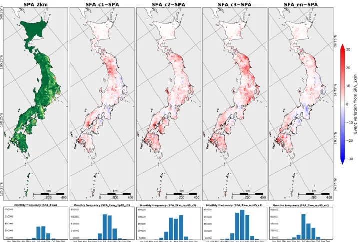
Comparison among the estimated risks obtained by the present and future climate datasets were performed. The results indicate a clear increasing trend of landslide risk in the whole Japan except some regions in Hyugo prefecture, area nearby Kii peninsula, and in Kanto in the side of Pacific Ocean. Particularly, larger increase of event can be found in Kyushu, Chugoku, and Tohoku regions, and slight increase in Hokkaido. The occurrence period concentrates on from July to September, and it exits slight occurrence in June and October. All results are illustrated in Fig. 1.
More detailed regional and seasonal changes as
well the relationship between snake line movement and field disaster conditions would be our next analysis targets. Through this research, we would like to contribute valuable and high-resolution mapping information of the future change of landslide risk for the governmental authorities.
Acknowledgement
This research is supported by the “Integrated Research Program for Advancing Climate Models (TOUGOU program)” from the Ministry of Education, Culture, Sports, Science and Technology (MEXT), Japan. The authors would like to appreciate MLIT Sabo Office and prefectural governments for providing valuable critical line information.
References
Osanai, N., et al. (2010). Landslide 7, 325-338. Fig. 1 Distribution of event frequency extracted from the present member (SPA_2km) of NHRCM02, and
variation of the future members (SFA_2km_c1, SFA_2km_c2, SFA_2km_c3, and SFA_2km_en) from SPA. Monthly histogram of event frequency for each distribution are illustrated in the lower row.