E205
Assessment of survivability of young oil palms against floods at a river basin scale
using remote sensing
〇Eva MS YAMAMOTO, Takahiro SAYAMA, Kodai YAMAMOTO, Apip
Summary
Palm oil is one of the key drivers of economic growth in some regions in the humid tropical countries such as Indonesia. However, previous studies showed the flood risk in the future will increase which threaten the sustainable production of palm oil. To date, there are only a few studies on the survivability of oil palms (OPs) against floods and most of them were carried out at laboratory or plantation scales. While most of flood risks studies were done at basin scale level, the survivability of OPs against floods at this scale remains poorly understood. One of the reasons is obtaining survivability data of through field survey for such large area is exhaustive.
This study proposed the use of remote sensing to assess the survivability of OPs at river basin (RB) scale. The OP distribution maps in 2015 and 2018 were obtained using Random Forest classification model from Sentinel-1 and 2 and the composite of flood extents in between years was obtained using Sentinel-1. Our results show that OP distribution at river basin scale can be obtained at accuracy of 87%. Furthermore, the study shows that only 6% of the flooded young OPs in 2015 could survive and reach maturity in 2018, while 35% remains young (slower growth/replanted) and 59% changed to other land uses (e.g. barelands/abandoned).
Introduction
Despite of the high economic loss against big flooding, there are only a few studies on the survivability of OPs against floods, and most of them
were carried out at laboratory scale or plantation scale. These studies show that immature OPs with age less than 3 years will likely not to survive prolonged floods [1][2] or floods that is higher than their leaf axils [3]. OPs which are planted in frequently flooded area has fewer biological activities than those in area with ideal water table [4] and yields 20-30% less fruits [5][6]. There are also cases where flooded mature OPs died due to physical damage (toppled over)[5].
Currently, industrial scale plantations are able to limit the economic loss due to floods by canalization and pumping. Furthermore, these companies obtained concession sites that has been surveyed to have infrequent flooding or no floods at all. Therefore, the current flood risks seem to be manageable for these companies. Small holder farmers, on the other hands, have limited resources to deal with floods and therefore affected more than the companies.
Based on several studies, flood risks in the future will increase due to LULC and climate changes. Yamamoto et al. (2021), mentioned that the flooding area at Batanghari RB, Indonesia will increase by 1.4 times and the maximum flood depth will increase from 3.7 m to 4.8 m in the year 2079 - 2098. The flooding will concentrate at downstream area where most of the OPs are located. Thus, managing future floods can be a lot harder than the current ones.
Study Area
This study used the Batanghari River Basin (42,960 km2) as a study area which covers part of Jambi and West Sumatra provinces. The two provinces are among the biggest palm oil contributors in Indonesia.
Methods
Based on the previous studies on OP life cycle, oil palms will reach maturity in 3 years after plantation. During this immature period, OPs are most vulnerable to flood (called young oil palms (YOP) here on). Mature oil palms (MOP) are more resilient to floods. Thus, this study aims to quantify how much of the flooded YOP can survive and achieve maturity within 3 years period.
To achieve this objective, this study produced three of maps i.e. OP distribution map at year t, OP distribution map at year t+3 and floods at year t to t+3. We selected year t = 2015 due to severe floods in the years of 2016 and 2017.
We used Sentinel-1 (radar scene) and Sentinel 2 (optical image) to obtain the OP distribution maps which distinguished YOP from MOP. For this purpose, we collected 5,455 points from 2015 Google Earth orthophotos where 50% were used for model training and the remaining were used for validation. The YOP were identified in orthophotos as OPs with crown projection area < 16 m2 [7]. The classification used random forest classifier and additional texture analysis such as Gray-Level Co-Occurrence Matrix (GLCM) and median filters were applied to improve accuracy. Composite of flood extent during 2016 and 2017 were obtained using Sentinel-1 imageries. The detailed algorithms will be presented.
Results
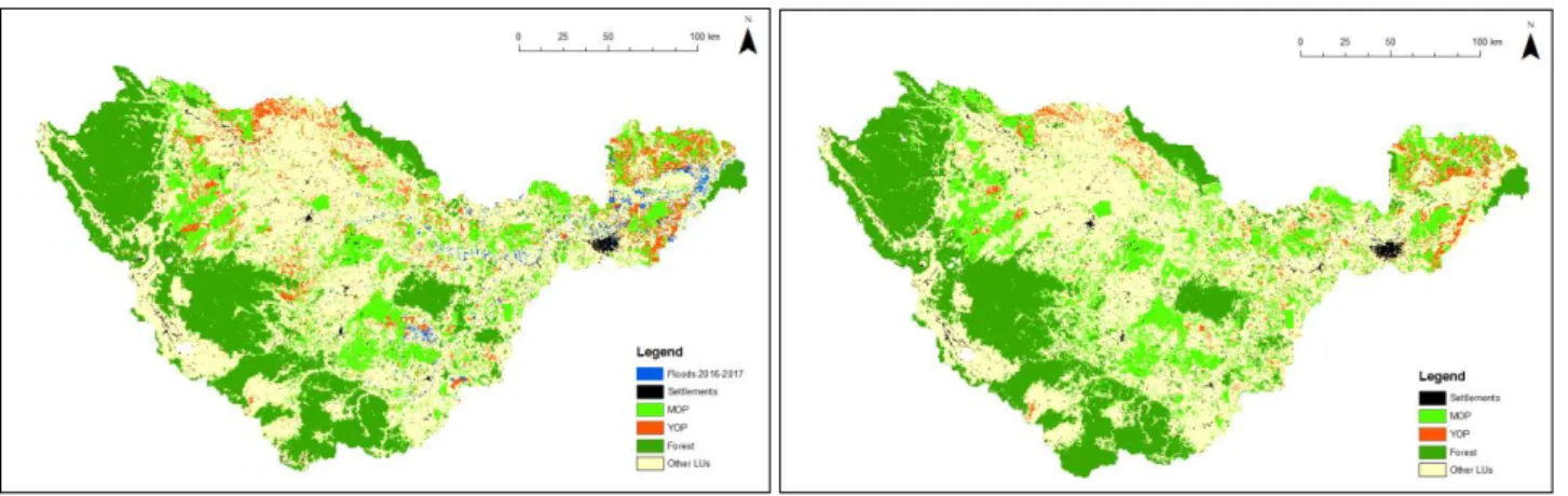
Figure 1 shows the results of classification of OP and other LUs in year 2015 and 2018 as well as
composites of flood extents during 2016 – 2017. The accuracy of OP classification is 87%. This study shows that non-commercial imageries can be used in classification of YOP and MOP at RB scale.
In 2015, OPs occupied 21% (8,902 km2) of the basin area and 29% of them categorized as YOP (2,580 km2). About 19% (498 km2) of the YOP were exposed to floods during 2016 – 2017. In 2018, only 6% of the flooded YOP reached maturity, whereas 35% remains young and 59% changed into other LUs. The flooded YOP may have slower growth or can be replanted between 2015 – 2018, thus some remained young. However, most of the flooded OP turned into other LU such as bare lands (abandoned) or other LUs. These findings are in line with the previous findings at laboratory and plantation scales described earlier. This study also shows that new YOP can be found in 2018 thus the area of distribution of OP in 2018 is slightly less but does not change much.
Conclusion
Survivability of flooded YOP at RB scale can be quantified using Remote Sensing. Classification YOP and MOP using Sentinel 1 and 2 at RB scale results in 87% accuracy. Only 6% of flooded YOP can be matured in time while 35% remains young and 59% turned into other LUs
Reference
[1] Government of Malaysia (1977), [2] Teoh CH et al. (2001), [3] Corley and Tinker (2015), [4] Henson et al. (2008), [5] Sumarga et al. (2016), [6] Abram et al. (2014), [7] Chemura et al. (2015).