Advances in River Sediment Research – Fukuoka et al. (eds)
© 2013 Taylor & Francis Group, London, ISBN 978-1-138-00062-9
Reservoir sedimentation and sediment management techniques in the Nile River basin countries
S.A. Kantoush
Civil Engineering Department, German University in Cairo, New Cairo City, Egypt
T. Sumi
Water Resources Research Center, Disaster Prevention Research Institute, Kyoto University, Japan
ABSTRACT: Currently, there are thirteen large dams on the Nile and around thirteen future dams planned. The Nile has been the major supplier of suspended sediment to the eastern Mediterranean Sea until the construction of the Aswan High Dam (AHD). The objective of water and sediment incor- poration is to manipulate the river-reservoir system to achieve sediment balance while maximizing the beneficial storage and minimizing environmental impacts and socioeconomic costs. The paper aims at reviewing the current state of Nile Basin reservoir sedimentation and sediment yield. It also summa- rizes the response of AHD to reservoir sedimentations of the newly constructed or planned dams in the upstream regions. As the Ethiopian Highlands are the main source of sediment, the river systems draining this region have witnessed severe sediment management problems since the construction of large dams.
Coordinated sediment management and dam operation are highly recommended for the cascade dams along the Blue Nile.
to serious reduction in reservoirs storage capacities and hence leading to hydropower generation prob- lems, banks flooding and ultimately negatively impact on the socio-economic lives of the users, environment and ecosystem in general. The reduc- tion of sediment supply in large alluvial systems due to sediment trapping in upstream reservoirs might lead to long-term impacts on the fluvial process.
One such example is the river channel down- stream of the Aswan High Dam (AHD) on the Nile River, where river bed degradation and bank erosion occurred and serious shore erosion was observed at the river mouth area. In the case of the AHD, the aggregate storage capacity of Lake Nasser, which is twice as large as the annual run- off of the Nile River at the dam site, is sufficient to change both the flow regime and sediment supply to the river channels downstream of the AHD. Thus, the downstream section of the Nile is transformed into a system with a non-equilibrium sediment transport process. As a result, the annual peak discharge has been reduced to less than a third of its original value, which caused navigation problems (Abdelbary 2004).
Dams and their reservoirs are constructed and operated for multipurpose including power gen- eration, flood protection, drinking water, agricul- tural water supply, recreation, fishing, and others.
1 INTRODUCTION
The Nile River is the main source of water for the eleven countries that make up the Nile basin as shown in Figure 1. The climate and hydrology of the Nile Basin (NB) ranges from Equatorial in the White Nile headwaters to arid in the desert region of northern Sudan and Egypt. Thus, for much of its course, the Nile is an exotic river (Woodward, et al. 2007). Stretching over 35 degrees latitude of the north-eastern African quadrant, the Nile River basin represents one-third of the entire African continent. With an area of almost 3,176,543 km2 extending over different geographical, topographi- cal and climatological regions, the basin spans over ten African countries: Burundi, Democratic Repub- lic of Congo (DRC), Egypt, Eritrea, Ethiopia, Kenya, Rwanda, Sudan, S. Sudan, Tanzania and Uganda, (Fig. 1).
NB catchment suffer severe land degradation and soil erosion due to extended dry seasons in some parts of the Basin, torrential rain and geolog- ical nature, bringing large quantities of sediment in the drainage systems (Abdelsalam, 2008). This leads to land degradation in the watershed and the upper lands, e.g. in Ethiopia Highlands in the east, and around upstream Lake Victoria in the south.
At the same time, the sediment deposition in the reservoirs and irrigation systems downstream lead
upstream. Kondolf (1997) has described that, by changing flow regime and sediment load, dams can produce adjustments in alluvial channels, the nature of which depends upon the characteristics of the original and altered flow regimes and sedi- ment loads.
Downstream impacts develop through disconti- nuity in downstream gradients, e.g., sediment sup- ply, water quality, temperature, flow and sediment regimes. Sediment deficit is not only an environ- mental issue but also a socio-economic problem, for instance due to loss of reservoir capacity (e.g., Fan and Springer, 1993). In addition, dams alter the downstream flow regime of rivers (Williams and Wolman, 1984), which controls many physi- cal and ecological aspects of river form and proc- esses, including sediment transport and nutrient exchange (Poff et al., 1997). Hydrological effects caused by dams include changes in flood frequency and magnitude, reduction in overall flows, changes in seasonal flows, and altered timing of releases. If flows released from dams have sufficient capacity to move coarse sediment, water becomes ‘hun- gry water’ (Kondolf, 1997), which may transport sediment downstream without replacement from upstream and the ecological effects on fluvial and deltaic systems.
Necessary elements of sediment management strategies for sustainable reservoirs are to collect enough data of deposited sediment for evaluation and select a suitable management technique for case by case. Furthermore, it is important to estab- lish techniques for redeveloping existing dams, by construction of sediment bypass, and to develop environmental impact assessment approaches.
These techniques minimize the minus impacts such as water quality change, and maximize the plus impacts such as the recovery of sediment routing.
Considering a sediment movement zone from Japanese alpine mountainous regions through coastal areas, a comprehensive approach has already been started in Japan to recover a sound sediment circulation in the sediment transport sys- tem. Reservoir sedimentation problems are com- mon in all countries, whether they are developed or developing countries. Therefore, it is necessary to exchange knowledge and collaboratively work for a solution with countries having the same prob- lems. Schleiss et al., (2008) presented the reasons, problems of reservoir sedimentation, and possible measures against sedimentation. Putting its experi- ence to use, Japan intends to make great interna- tional contributions to the promotion of reservoir sedimentation management in the field of techno- logical development in future.
Current state of Nile Basin reservoir sedimenta- tion and sediment yield is presented. Dam impacts on flow and sediment discharges to Nasser Lake Figure 1. Map of the Nile Basin showing basin sources,
the Nile course and the drainage network (Nile Basin Initiative, State of the River Nile Basin 2012).
Until now in the Nile Basin (NB) the common engineering practice has been to design and oper- ate reservoirs to fill with sediment. With such an approach, the consequences of sedimentation and project abandonment are left to be taken care of by future generations. Therefore we need to develop ingenious solutions for integrated sediment and water management; unless we will lose the struggle to enhance the available water resources. Regardless of their purpose, all multipurpose dams trap sedi- ment and inevitably lead to physical and ecological changes downstream of the reservoir site, as well as in the reservoir itself, and in some cases also
life span should be clarified and discussed. As the Ethiopian Highlands are the main source of suspended sediment in the basin, the river sys- tems draining this region have witnessed some of the most severe sediment management problems.
There are still key gaps in our understanding of basin-wide sediment dynamics in the Nile. This paper is to review the reservoir sedimentation sta- tus in the Nile basin.
2 THE ENVIRONMENTS OF NILE BASIN The Nile is a major north-flowing river in north- eastern Africa, and the major rivers of the NB are the Main Nile, the Blue Nile, the Atbara, the White Nile, the Rahad, the Dindir, the Sobat, the Akobo and the Baro, which are shown in Figure 2. Formed by the confluence of the three main tributaries, White Nile, Blue Nile and Atbara River, the Nile River flows over 6’695 km from the south glaciated highlands through alluvial plains and desert sands into the eastern Mediterranean (NBI, 2012). The most distant source of the Nile is the Ruvyironza River, which flows into Lake Victoria through the Ruvubu and Kagera rivers. From Jinja in Uganda, the White Nile emerges from Lake Victoria as the Victoria Nile, and travels northwards, passing through two other Equatorial Lakes—Kyoga and Albert. The river re-emerges from Lake Albert as the Albert Nile and journeys northwards to Nimule near the South Sudan–Uganda border. From this point, the river, now known as the Bahr el Jebel (mean- ing river of the mountains), flows over the Fula rapids and through the Sudd before meeting the Bahr el Ghazal (meaning river of the gazelles) at Lake No (Fig. 1). The Bahr el Ghazal drains high rainfall areas of western South Sudan. From Lake No, the river turns eastwards to join with the Sobat River, which carries high, seasonally varia- ble, flows originating in the Ethiopian Highlands.
The combined Bahr el Jebel and Sobat rivers form the White Nile, which continues its north- ward descent and meets with the Blue Nile at Khartoum, The Sudan. The Blue Nile (also known as the Abbai or Abay) originates in Lake Tana in Ethiopia, and is the second principal stream of the Nile. Before meeting the White Nile, the Blue Nile is joined by a number of rivers, the main ones being the Rahad and Dinder, both originating in the Ethiopian Highlands. From Khartoum, the combined rivers of the Nile flow northwards, and are joined by the Atbara (Tekezze), also originat- ing in the Ethiopian Highlands. The Main Nile continues travelling northwards and flows into Lake Nasser. The Nile eventually discharges into the Mediterranean Sea via its delta.
The longitudinal profile of major rivers in the ENB is shown in Figure 2. The Akobo and the Baro are two rivers in the upper part of ENB.
The Baro Originates at an elevation of 2,200 m and the Akobo at an elevation of 1,000 m. These two rivers meet the Sobat River which joins the White Nile. The Blue Nile originates at Lake Tana at an elevation of 1,800 m which meets the White Nile at Khartoum at an elevation of about 350 m and commonly regarded as Main Nile. Finally it falls in the Mediterranean Sea. In the Main Nile the High Aswan Dam is one of the major dams where river elevation falls about 100 m.
2.1 Hydrology of the NB
The spatial pattern of rainfall inputs across the Nile Basin is highly variable. Local water resources are minimal in the arid and semi-arid regions of Egypt and Sudan, and evaporation and seepage losses are high in this part of the basin (UNEP, 2000). Precipitation dynamics in the Blue Nile and Atbara headwaters are influenced by three main mechanisms (Conway, 2000): (1) the sum- mer monsoon; (2) tropical upper easterlies; (3) local convergence in the Red Sea coastal region.
About 70% of the annual rainfall in the Blue Nile headwaters of Ethiopia falls between June and September declining from 2000 mm in the southwest to less than 1000 mm in the northeast (Conway, 2000). On average about 85% of annual flow of the Blue Nile is concentrated into one third of the year between July and October. The 1900 to 1982 gauging station records for the Blue Nile at Khartoum show a mean monthly range in discharge from 9 to 8834 m3/s with a mean of 1513 m3/s. The flow regime of the Atbara exhibits even greater seasonality and the river is commonly dry from December to May with very low flows in November and June.
The present average contributions from each of the three main tributaries to the entire Nile River Figure 2. Longitudinal profiles of the major rivers in
the NB.
flow are schematically represented in Figure 3.
Runoff from the Ethiopian Plateau via the Blue Nile and Atbara accounts for roughly 70% of the annual water discharge, whereas the White Nile contributes about 30% (Roskar, 2000). Although the contribution of the White Nile to the total annual flow is rather small, the White Nile is most important because of its continuous flow during the dry season when its discharge is large com- pared to that of the Blue Nile.
Subject to seasonal variations, about 80% of the total annual discharge of the River Nile occurs during the summer rainy season (July to October) mainly with the Blue Nile and the Atbara River (Woodward et al., 2001). Atbara River runs dry at times of the year while the White Nile maintains the flow in the Nile over the entire year. Without the discharge of the upper White Nile the Nile River would probably run dry in May. More than 95% of the mean annual suspended sediment load of the Nile River upstream of the Aswan High Dam (120 Million t/yr, Woodward et al. 2001) comes with the Blue Nile (72%) and the Atbara River (25%) whereas the White Nile contributes only 3% of the total load. Apart from seasonal variations, the total annual discharge of the Nile River is subject to intense annual variations with the highest annual flows of 154 km3/yr recorded in 1878 (Abu Zeid, 1987) and 120 km3/yr measured in 1984 (Woodward et al., 2001). The lowest annual flow on record was observed in 1913 with only 42 km3/yr (Abu Zeid, 1987). The mean annual flow of the Nile River and the three tributaries calculated over the period 1901–1995 (Mohamed et al., 2005).
2.2 Sediment yield and suspended sediment budget This section examines the sediment production and suspended sediment budget of the basin upstream of the delta complex sedimentation in reservoirs.
The sedimentation problems in the ENB started from the Ethiopia. Rainfall in the Ethiopia High- lands falls on bare lands at the beginning of the rainy season in July and brings high sedimentation
load before the maximum runoff occurs in the area.
The highest sediment concentrations occur in the rising flood waters in late July to the first ten days of August. The average specific sediment yield rate of the basin is 9000 ton/sq. km/yr (Shenkut, 2006).
The Hydraulics Research Station (HRS) under the MWRI, the Sudan measures sediment concen- tration and discharge in several locations of the Gezira Scheme canalization system. It has con- cluded that 5% of the sediment settles in the main canals, 23% in the major canals, 33% in the minor canals and 39% passes into the farm fields. The huge reduction of the original capacity of the Sudan res- ervoir due to sedimentation is easily noticeable. The Sennar lost 66%, the Girba 60% and the Roseires 30% (Ahmed, 2006). Suspended sediment concen- trations and loads have been measured at several stations on the Egyptian Nile-especially in the dec- ades leading up to the planning and construction of the Aswan High Dam—but continuous long- term records are not presently available in the scien- tific literature. The suspended sediment load of the Nile is rather modest in comparison with its basin area. Milliman and Syvitski (1992) quote a value of 120 million tonnes year1 for the average annual pre-Aswan High Dam load and a mean annual sed- iment yield of 40 t km2 year1.
It is important to realize that sediment produc- tion and sediment delivery vary markedly in the major tributary basins and marked spatial and temporal (annual and seasonal) variability in sus- pended sediment flux. Suspended sediment con- centrations and loads are subject to considerable annual variation. According to Abu El-Ata (1978) the annual sediment load of the Nile at Aswan has varied between 50 and 228 million tons. Due to the erodible upland terrains, high sediment supply and high runoff, much of the suspended sediment load measured at Aswan derives from the highlands of Ethiopia. In fact, together the Blue Nile and Atbara contribute on average about 97% of the Nile’s annual suspended sediment load (with about 72% from the Blue Nile and 25% from the Atbara) and the White Nile the remaining 3.0% (Fig. 4)
Figure 3. Water balance at Eastern Nile Basin.
Figure 4. Daily flow and suspended sediment concen- tration for summer floods at Wadi Halfa and Gaafra (Shahin, 1985).
(Foucault and Stanley, 1989). Suspended sediment flux is dominated by the summer flood in the Blue Nile and Atbara catchments.
For example, with a peak flow to low flow ratio of 40:1, and typical mean August and June sedi- ment concentrations of 4000 and 100 mg/l, respec- tively, the Blue Nile can transport up to 1600 times more sediment during the summer floods than at the end of the dry season (Williams et al., 1982).
The White Nile drains the resistant rocks of the Equatorial plateau and these terrains have much lower erosion and a more effective cover of protec- tive vegetation in contrast to the deeply dissected Blue Nile headwaters. Consequently, suspended sediment concentrations are much lower in the floodwaters of the White Nile and the lower gradi- ent White Nile is a much less efficient suspended sediment delivery system (Fig. 4). A significant proportion of its suspended sediment load is also trapped in the swamps and marshes of the Sudd region in the middle White Nile reaches. In the main Nile at Aswan the sediment wave tends to peak in August before the main flood peak and several weeks may separate these two events. The suspended sediment concentrations for the summer flood of 1955 at Gaafra (near Aswan) peak at over 5500 mg/l in mid-August and then decline steadily to 500 mg/l by the end of October (Fig. 4).
2.3 Dams on the Nile River Basin
Summarized by El-Hinnawi (1980), the Nile River control measures started in the early 19th century when a series of barrages were built to transform the old recession irrigation system to perennial irrigation so that instead of growing one crop per year, two or three corps could be grown on the same land. The Delta Barrage was built just below Cairo to control the Rosetta and Damietta branches of the Nile together with the Zift a Bar- rage on the Damietta branch. Constructed in 1902 and enlarged in 1938, a dam at Assiut was built to provide perennial irrigation in central Egypt.
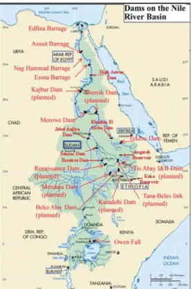
In 1908, the Esna Barrage followed by Nag- Hammady in 1930 was constructed on the Nile River to improve the water supply for irrigation schemes in Upper Egypt. Figure 5 shows the large dams on the Nile and the location of one of the planned dams as well.
The new Aswan High Dam, designed to be never drained, caused a revolution in the Egyptian irrigation system. Practically, all the fertile sedi- ment from the Ethiopian Plateau was deposited in the reservoir. Although the missing suspended particles created certain disadvantages, the extra stored water and the reduction of silting in the irrigation channels allowed the perennial irrigation as well as a significant increase in irrigated area.
Figure 5. Map of the Nile Basin showing location of large dam on Nile.
About 45 km south of Kharthoum, the Jebel Aulia reservoir was constructed in 1937 to hold back part of the White Nile flow during rich discharge of the Blue Nile. Since the Nile valley upstream of Jebel Aulia is very flat and open, a large quan- tity of water is being lost due to evaporation and seepage.
The Owen Falls Dam (Fig. 5) completed in 1954 was the first control work on the upper White Nile. With a primary goal of producing hydroelec- tric power, the dam controls the outflow of Lake Victoria and therefore created the largest reservoir in the world. In 1999, after a year-long debate, the Ugandan Parliament approved the construc- tion of the Bujagali hydropower dam as a private hydroelectric power plant project in Uganda.
The project is one of several hydropower plants planned to be scattered along the upper reaches of the White Nile including Owen Falls, Busowoko, Ralangala, Raruma, Ayago North, Ayago South and Murchison Falls. Situated 1’100 m a.s.l. at Bujagali Falls, about 8 km north of Lake Victoria, construction of the Bujagali plant was due to begin in January 2003, but was initially delayed after vocal protests by environmentalists and residents
of the area. In February 2005, the Ugandan Government announced that the project will go ahead. With a volume of up to 750’000 m3 and a verti- cal drop of 30 m, the reservoir water will feed four tur- bines with a total installed capacity of 250 MW.
On the Blue Nile, the Sennar Dam (Fig. 5) completed in 1925 serves the needs of Sudan by providing the basis for the Sudan’s agriculture economy. Its main function is to store water for the Gezira irrigation scheme during the flood season of the Blue Nile. Further upstream, near the Sudan- Ethiopian border, the Roseires Dam was completed in 1966 with the two primary pur- poses of increasing the storage capacity of the Blue Nile water and producing hydropower. Far above Roseires, below the Blue Nile Gorge, Lake Tanna (Ethiopia) was considered for many years as a good place for a storage reservoir to hold back a large proportion of the Blue Nile flood.
The first one is the Chara Chara weir that regu- lates the Lake Tana outflows to the 5 Tis Abbay power complex, located some 32 km downstream the Lake. Then, the Tana-Beles scheme (started operation in May 2010) consists of an artificial link between the Lake Tana and the Beles river to generate hydroelectricy and aims at irrigate around 150 000 ha in the future. In the upper Ethiopian part of the Atbara sub-basin (Tekeze river in Ethiopia), the largest Ethiopian hydraulic infrastructure. With an over-year storage capacity and an installed capacity of 300 MW, the Tekeze dam started to generate hydropower in 2009 and aims to produce around 30% of current total national electric production.
A large hydropower and irrigation project is newly constructed on the Tezeke River in the Tigray Region of northern Ethiopia. The Tezeke Dam with a height of 185 m will be 10 meters higher than the highly controversial Three Gorges Dam in China. In his study Aforki (2006) reported that 40% of the reservoir storage capacity is provided as a room for the sediment inflow throughout the 50 years design life time of the dam. Therefore the dead storage is about 3.7 billion m3. Hence the rate of sedimentation expected annually is about 75 million m3 i.e. less than 1%. The sediment data in the feasibility study report of the dam is lim- ited; hence the rate of sedimentation of Tekeze reservoir still remains unpredicted. No doubt the sediment load in Tekeze River is large compared to other Nile basin systems, since it falls within a dry area with torrential rainfall during short period (July–Sept).
Recently constructed, the Merowe Dam on the Nile River, about 800 km north of the capi- tal Khartoum (Sudan) is the largest contempo- rary hydropower project in Africa. Merowe dam will submerge the Fourth Cataract of the Nile
and form a 200 km long artificial lake. Monenco (1993) estimated the storage capacity of the reser- voir at level 298 masl as 11.05 billion m3 equiva- lents to a pool reservoir surface area of 724 km2. The low supply level (290 masl) corresponds to 476 km2 surface area and 6.17 billion m3 i.e. live storage of 4.88 billion m3 would be available.
However recently it was decided to raise the full supply level to 300 masl, which correspond to a storage capacity of 12.4 billion m3. The dam is 67 m high with 1250 MW hydropower generation capacity, which was completed on 2009. Estimates of sediment from Monenco, (1993) study indicated average suspended sediment load into Merowe reservoir as 134 million t/yr for the period 1929 to 1964, 121 million t/yr in 1971 and 181 million t/yr in 1990. Monenco (1993) added 25% to the esti- mated suspended load as bed load, which resulted in 180 million t/yr total sediment load received by Merowe reservoir. It was then concluded that over 50 years after the project implementation the total deposited sediment into the reservoir will be 4.24 billion m3.
2.4 Reservoir sedimentations in the NBC On the Nile system there are several dam reser- voirs: two in Uganda, four in Ethiopia, five in Sudan, and two in Egypt. However, in the Nile Basin several new dams are planned for different purposes. Assessments of sediment information in the Nile Basin show that suspended sediment dominates the total sediment in transport and few meaningful of bed load transport have been undertaken for the Nile system. Available data suggests that suspended sediment commonly accounts for approximately 90% of the total sedi- ment load. Reservoir surveys to determine the vol- ume of deposited sediment and hence the loss in capacity by bathymetric survey and other means seem to be made often for larger than smaller size reservoirs. AHD in Egypt is the most frequently surveyed reservoir followed by Roseires and Sennar reservoirs and less so by Khashm ElGirba reservoir in Sudan. Angereb and Koka reservoirs in Ethiopia and Owen and Bujagali reservoirs in Uganda have not been surveyed so far. Smaller reservoirs (Angereb, Koka, Sennar and Khashm El Girba) are impacted more adversely by reser- voir sedimentation than the larger ones (Roseires and Aswan) because the relative loss in capacity is much faster.
In Egypt the deposited material in Lake Nasser has resulted in delta formation and affects the useful life of the reservoir see Figure 6 for sedi- ment process in Lake Nasser Reservoir. The total deposited sediment in AHD reservoir ranges between (3.014 r 109 m3 and 3.732 r 109 m3).
3 SEDIMENT MANAGEMENT TECHNIQUE IN THE NBC
Although there are several large dams on the Nile Basin that are subjected to high suspended sedi- ment budget and sediment deposition, there is no effective sediment management techniques imple- mented in integrated way. Most of Nile Basin res- ervoirs have traditionally been planned, designed, and operated on the assumption that they have a finite (life), frequently as short as 100 years, which will eventually be terminated by sediment accu- mulation. However, the sustainability criterion was recently introduced by United Nation (UN) towards the end of the last century to suggest a minimum of 1000 years of operation for new designed reservoir projects.
Downstream, water released from the dam pos- sesses the energy to erode the channel bed and banks, but has little or no sediment load. The rapid reservoir sedimentation not only decreases the storage capacity, but also increases the prob- ability of flood inundation in the upstream reaches due to heightening of the bed elevations at the upstream end of the reservoir and the confluences of the tributaries. In order to remove and reduce reservoir sedimentation, many approaches such as flushing, sluicing, dredging and water and soil con- servation are developed (ICOLD, 1989).
Among these approaches, flushing is consid- ered the only economic approach to swiftly restore the storage capacity of the reservoir with severe deposition. Basically, there are two types of flush- ing operations with, and without drawdown, and optional techniques can be used with the complete drawn flushing as shown in Figure 7. Drawdown is the lowering the water levels in a reservoir.
Hydraulic flushing involves reservoir drawdown by opening the bottom outlet to generate and acceler- ate unsteady flow towards the outlet (Morris and Fan, 1998). This accelerated flow possesses an increased stream power and consequently erod- ing a channel through the deposits and flushing the fine and coarse sediments through the outlet.
During this process a progressive and a retrogres- sive erosion patterns can occurs in the tail and Figure 6. Sediment distribution in Nasser Lake and
newly formed Delta in the reservoir.
The percentage of losses from the dead storage zone (under level 147 m) ranges between (3.3%
and 3.348%). The percentage of losses from the life storage zone (between level 147 m and 175 m) ranges between (2.9% and 2.97%). The percent- age of losses from the total reservoir capacity (162 r 109 m3 at level 182 m) ranges between (2.3%
and 2.304%). Suitable methods to control sedimen- tation and water quality deterioration necessitate the importance of using coupling model in order to perceive a better understanding to the problem.
This is to minimize the expected impacts and pro- pose mitigation measures. Mitigation measures may include revising and improve the operation system, using river regulation works such as dredg- ing or flushing and pollution control.
The Roseires Dam (1966) on the Blue Nile and the Khashm el Girba Dam (1964) on the Atbara River (Fig. 5) both encountered major problems with sedimentation within a decade of their construction (Elsheikh et al., 1991). The Roseires Dam was built close to the Ethiopian border to store Blue Nile water for irrigation use in central Sudan. According to these authors, the storage capacity of the Roseires reservoir (3.02 r 109 m3) had fallen by 18% after 10 years and 21% after 15 years—while the capacity of the Khasm el Girba reservoir fell by 25.4% after 7 years of operation and by 42.3% after 12 years.
Bathymetric survey showed that 540 million m3 of sediment had been deposited in the Roseires reservoir between 1966 and the 1975/1976 hydro- logical year—giving a mean annual value for sediment deposition of about 54 million m3 for this period. The total volume of deposited sedi- ment had increased to 640 million m3 by 1980/81
(Elsheikh et al., 1991). Figure 7. Classification of sediment flushing techniques.
delta reaches of the reservoir, respectively (Batuca and Jordaan, 2000).
For instance in Roseires and Khashm ElGirba Dams the most effective sediment strategy is to apply regulation rules to operate the reservoir tak- ing into consideration how to get rid of the maxi- mum possible quantity of sediment and pass it downstream. Drawdown, sediment sluicing during the rainy season and impounding only after the passage of the peak of the flood are the preferred methods to control sediment deposition in the Sudanese reservoirs. Both reservoirs are provided with low-level sluicing gates with discharge capac- ity comparable to river annual flood flows. In the case of hydropower generation in Roseires reser- voir, low level sluices are intended to pass the bulk of the larger sediment particles which are presence during the flood season to minimize abrasion of the runner blades of the turbines. Removal of the already deposited sediment is rather very limited for most of the reservoirs in the Nile. Occasional flushing is made in Khashm ElGirba reservoir.
Sediment removal by dredging is regularly made in Roseires reservoir in front of the power house intakes before the following flood. Excavation or dredging of the deposited sediment is rather very limited for most of the reservoirs in the Nile.
Occasional flushing is made in Khashm ElGirba reservoir. Sediment removal by dredging is regu- larly made in Roseires reservoir in front of the power house intakes before the flood.
Even for the newly constructed dams on the Blue Nile as Tekeze reservoir, almost the same strategy of sediment management has been imple- mented, where 40% of the reservoir storage capac- ity is dead storage throughout the 50 years design life time of the dam. Therefore the dead storage is about 3.7 billion m3. Aforki (2006) concluded his study with three different scenarios for the reduction of the sedimentation in Tekeze reservoir through flushing (i) Empty drawdown; (ii) Partial drawdown and empty drawdown but after the dead storage is filled; (iii) Four hydro-suction pipes options with different diameter (300 mm; 600 mm;
900 mm and 1200 mm). Therefore, further study based on reliable and consistent time series sedi- ment monitoring techniques is required in order to reach a technically sound estimate of sediment both in terms of quantity. Lessons should be learned from the Roseires reservoir design which was based on very limited sediment strategy.
To evaluate the influence of sediment flush- ing for three of reservoirs (Roseires, Merowe, and Shereik dams) in Sudan, 1D numerical model MIKE11 was used by Eizel-Din et al. (2010), to estimate the long-term water and bed level changes due to reservoir impounding and to optimize the flushing activities during flood times. Roseires
dam was constructed in 1966 on, Merowe dam was completed on 2009, and Shereik dam is under plan- ning. Based on Brune’s curves the estimated value of the trap efficiency of the Roseires reservoir was estimated to be about 79%. However, after 10 years of operation the sediment deposited in the reser- voir revealed that the trap efficiency was 45.5%
and then decreased dramatically to 26.2% after 30 years. Based on the numerical simulation Eizel-Din has concluded that the trap efficiency will decrease from 39% after 10 years to 30.3% after 100 years for the case without flushing. Applying flushing schemes, the trap efficiency will decrease from 25.5% after 10 years to 23% after 100 years.
The question is how these newly constructed dams will influence on the AHD operation and Delta formation. Merowe reservoir is going to face serious sedimentation problems by receiving sedi- ment load for both rivers (Blue Nile and Atbara River). The upstream dams in the upstream coun- tries will reduce the sediment yield to AHD and the water quality in Nasser Lake will be questionable.
Moreover, the inflow discharge to AHD reservoir is questionable and important issue for Egypt.
3.1 Sedimentation and expected life of AHD A number of estimates of the expected life span of Lake Nasser located in Egypt and Sudan has been made in the past several years. Published estimates range from as little as 20 years (Sterling 1970) to over 1500 years (Makary 1982). The wide range of differing values is a function of many variables, including computation method, input data, and theoretical assumptions underlying the mathemat- ical approach taken. Such a broad range of values is typical of sedimentation studies performed for areas that lack an adequate historic data base. The trap efficiency of Lake Nasser/Nubia is close to 100% and this has created a dramatic shift in sedi- ment dynamics and geomorphological processes in the reaches downstream of the Aswan High Dam.
The sluices of the dam are opened periodically to maintain main channel flows for navigation, irrigation and for hydroelectric power. Between 1965 and 1973 the mean flux of suspended sedi- ment passing through the Aswan High Dam was estimated to be about 2.5 million tons (Shahin, 1985). Stanley and Wingerath (1996) state that about 98% of the sediment load (mainly silt and fine sand) that had previously been transported to the delta and the Mediterranean Sea is depos- ited in Lake Nasser/Nubia and clay-sized material (2 Mm) is now the major particulate fraction trans- ported from the reservoir behind the Aswan High Dam to the downstream reaches of the Egyptian Nile. The Ministry of Water Resources and Irrigation (MWRI) of Egypt carries out sediment
investigations three times a year, before, during and after the flood period. It can be noticed from the historical records that the sediment concentration decreases from 3000 ppm to just around 40 ppm, before and after AHD respectively see Figure 8.
It has been noticed that almost all the sediment deposition occurs in the Nile reach between 345 km and 430 km south of the dam site. In this region, sediment has already deposited in the live storage zone. However, several studies showed that until 1973, 99.98% of sediment was deposited in Lake Nubia. Available data suggests that suspended sed- iment dominates the total sediment in transport, which account to approximately 90% of the total sediment load. This means less than 10% is left for the bed load. If we assumed all the suspended sedi- ment is deposited in the reservoir plus 10% for the bed load (10 million tons), hence the expected life span of the AHD is over 1000 years. However, the dead storage requires about 200 years to be filled, but unfortunately most of the sediment if not all is deposited in the live storage, which slightly reduces the function of the dam.
It can be noticed that sediment deposition started at the tail zone of the reservoir and steadily progresses northward along the river bed. Several research studies suggest that the dead storage capacity was estimated to be sufficient to accom- modate sediment load (130 million m3/ year) for 300 to 500 years. It has been proved that the char- acteristics of rocky-narrow channel of the south- ern part of Lake Nubia work as a place for a new delta formation on the sides of the lake. A number of estimates of the potential life span of Lake Nasser located in Egypt and Sudan was published, ranging from 20 years to over 1500 years, Makary (1982). The time forecasted for filling the reservoir by sediment deposition is estimated by MWRI to be 362 years, which is less than the original design life span of 500 years.
Stanley (1996) has described the sediment depo- sition in Lake Nasser as ‘the New Nile delta’, and by the mid-1990s this rapidly growing feature was about 200 km long, 12 km wide and about 40 m thick—extending northwards to Abu Simbel. When the annual flood reaches Lake Nubia, the flow veloc- ity falls from 1.0 m s1 to about 0.02 m s1 (Shahin, 1985). Thus, the trap efficiency in the Aswan High Dam is close to 100% and under normal condi- tions only the finest fractions of the suspended load are transported to the downstream portion of the reservoir. The total volume of deposited sedi- ment between 1964 and 1998 has been estimated to be 3.5 km3 and 90% of this sediment is within the Sudanese side of the reservoir (El-Manadely et al., 2002). This estimate is based on a series of re- surveys of the original Nile river channel bed levels and valley floor cross-sections that were conducted before the construction of the dam.
In Figure 9, dams in the worldwide are plotted by the parameter of the turnover rate of water (CAP/MAR Total capacity/Mean annual runoff)
Figure 8. Mean monthly discharges and suspended sediment concentrations before and after the construc- tion of AHD (El-Manadely et al., 2002).
Figure 9. Reservoir operation and classification of sediment management techniques in the worldwide and in the Nile River Basin.
and sediment (CAP/MAS Total capacity/Mean annual inflow sediment) (Sumi, 2003). The selected sediment management measures are changed by these two parameters. It is understood that meas- ures actually selected have changed in the order of the sediment flushing, the sediment bypass, sedi- ment check dam and excavating, and dredging as CAP/MAR increases. This is because of greatly depending on the volume of water to be able to use the sediment management measure that can be selected for the sediment transport (Sumi, 2000).
Several research studies suggest that the dead storage capacity was estimated to be sufficient to accommodate sediment load (130 million m3/ year) for 300 to 500 years. However, almost all the sedi- ment load reaching the AHD reservoir deposited in the live storage. A number of estimates of the potential life span of Lake Nasser located in Egypt and Sudan was published, ranging from 20 years to over 1500 years, Abdelsalam, (2008). The time forecasted for filling the reservoir by sediment deposition is estimated by MWRI to be 362 years, which is less than the original design life span of 500 years. AHD as the second largest artificial Lake in the world has its positive and negative impacts on the region and the socio-economic development of Egypt in particular.
4 CONCLUSIONS
It is clear from this review that any discussion of the sediment production and reservoir sediment man- agement techniques of the Nile Basin must be set within an integrated sediment management. Assess- ing issues, depending on each case, of dam security, sustainable management of water resources and sediment management in a sediment transport sys- tem, we have to draw up an effective sediment man- agement plan with a limited budget and take specific action. Needless to say, of course, our best endeav- ors should be exerted to minimize negative environ- mental impacts involved in sediment management.
A successful sediment management proceeds from a permanent change in river management: Sediment management is a relatively new issue which is nei- ther well understood nor accepted.
Monitoring techniques are useful to evaluate sediment transport during flushing, and should be intensively studied and developed to support sedi- ment management strategies.
Reservoir sedimentation management in Japan is entering a new era. Although there are still tech- nical problems to be solved, it is believed that the importance of sediment management will increas- ingly grow. Assessing issues of dam security, sus- tainable management of water and sediment in a sediment routing system, an effective sediment
management plan should be studied. The comple- tion of the new dams at the upstream of AHD will result in a marked reduction in flow and suspended sediment budget to Lake Nasser; stakeholders need to recognize that the river transports sedi- ment addressed in the management equation. It is a complex undertaking. Exact answers to all ques- tions will not be known in advance.
REFERENCES
Abu El-Ata, A. 1978. Egypt and the Nile after the High Aswan Dam. Ministry of Irrigation and Land Recla- mation, Egypt.
Abu Zeid, M. 1987. Environmental Impact Assessment for the Aswan High Dam. Water Research Center, Ministry of Irrigation. In: Biswas A. and Q. Geping (Eds) Environmental Impact Assessment for Develop- ing Countries, pp 168–190.
Abdelbary, M.R. 2004. Physical and environmental impact of Aswan High Dam on the Nile River. Proc., 9th Int. Symp. on River Sedimentation, Vol. 1, Tsing- hua University Press, Beijing, 170–175.
Abdelsalam, A.A. 2008. Sediment in the Nile River System. UNESCO-IHP.
Aforki H.G. 2006. Sediment Studies for Tekeze Hydro- power Development, University Library (BIBSYS), Norwegian Centre for International Cooperation in Higher Education.
Batuca, D.G. and Jordaan, J.M., 2000. Silting and desilt- ing of reservoirs. A.A. Balkema, Rotterdam.
Batalla, R.J. 2003. Sediment deficit in rivers caused by dams and instream gravel mining. A review with examples from NE Spain. Cuaternario y Geomor- fología 17(3–4):79–91.
Conway, D. 2000. The climate and hydrology of the Upper Blue Nile River. The Geographical Journal, 166(1), 49–62.
El-Hinnawi, E.E. 1980. The state of the Nile Environment:
An Overview. Water Supply & Management 4: 1–11.
El-Manadely, M.S., Abdel-Bary, R.M., El-Sammany, M.S.
and Ahmed, T.A. 2002. Characteristics of the delta formation resulting from sediment deposition in Lake Nasser, Egypt: approach to tracing lake delta formation. Lakes and Reservoirs: Research and Management, 7, 81–86.
Elsheikh, S., Kaikai, A. and Andah, K. 1991. Intensive sediment transport from the Upper Nile Basin and water resources management in Sudan. In: Hydrology for the Water Management of Large Rivers (F.H.M.
van de Ven, D. Gutknecht, D.P. Loucks and K.A.
Salewicz, Eds.). IAHS Publication No. 201, 291–300.
Fan, S., and F.E. Springer. 1993. Major sedimentation issues at the Federal Energy Regulatory Commission.
In: Fan, S., Morris, G. (Eds.), Notes on Sediment Management in Reservoirs. Water Resources Publica- tions, Colorado, USA, 1–8.
ICOLD. 1989. Sedimentation control of reservoirs.
International Committee of Large Dams.
Kondolf, G.M., 1997. Hungry water: effects of dams and gravel mining on river channels. Environmental Management, 21(4): 533–551.
Milliman, J.D. and Syvitski, J.P.M. 1992. Geomorphic, Tectonic control of sediment discharge to the ocean:
the importance of small mountainous rivers. The Journal of Geology, 100, 525–544.
Morris, G.L. and Fan, J., 1998. Reservoir sedimentation handbook: Design and management of dams, reser- voirs, and watersheds for sustainable use. McGraw- Hill.
Monenco 1993. Merowe multi-Purpose Hydro-Project”, Feasibility Study, Volume I–VI, MOIWR, Sudan.
Poff, N.L., J.D. Allan, M.B. Bain, J.R. Karr, K.L.
Prestegaard, B.D. Richter, R.E. Sparks, and J.C.
Stromberg. 1997. The natural flow regime: a paradigm for river conservation and restoration. Bioscience 47(11):769–784.
Shahin, M.1985. Hydrology of the Nile Basin. Elsevier, Amsterdam, 575 pp.
Schleiss, A., De Cesare, G., Jenzer, J. 2008. Reservoir sed- imentation and sustainable development, Presented in CHR Workshop Erosion, Transport and Deposition of Sediments, Berne, Switzerland.
Shalash, A. 1982. Effects of sedimentation on the stor- age capacity of the High Aswan Dam reservoir.
Hydrobiologia, 92(1), 623–639.
Stanley, D.J. and Wingerath, J.G. 1996. Nile sediment dis- persal altered by the Aswan High Dam: the kaolinite trace. Marine Geology, 133, 1–9.
Sumi, T. and Kantoush, S.A. 2010. Integrated Manage- ment of Reservoir Sediment Routing by Flushing, Replenishing, and Bypassing Sediments in Japan River Basins, 8th International Symposium on ECO- HYDRAULICS (ISE 2010), COEX, Seoul, Korea, pp. 651–673.
Sumi, T. and Kantoush, S.A. 2010. Stochastic sediment deposition processes of large reservoirs in Japan, 11th Int. Symp. on River Sedimentation (ISRS), South Africa, pp. 1–11.
Sumi, T. and H. Kanazawa. 2006. Environmental Study on Sediment Flushing in the Kurobe River. 22nd International Congress on Large Dams, Barcelona, Q.85-R.16, 219–242.
Sumi, T., K. Kobayshi, K. Yamaguchi, and Y. Takata.
2009. Study on the applicability of the asset manage- ment for reservoir sediment management. Interna- tional Congress on Large Dams, Brasilia, Q.89-R.4.
UNEP, 2000. Water Sharing in the Nile River Valley.
Project GNV011: Using Remote Sensing for the Sus- tainable Use of Natural Resources. UNEP, Geneva, 85 pp.
UNESCO, 1978. World Water Balance and Water Resources of the Earth. UNESCO Studies and Reports in Hydrology No. 25, Paris.
Williams, G.P., and M.G. Wolman. 1984. Downstream effects of dams on Alluvial Rivers. US Geological Survey Professional Paper 1286.
Woodward JC, Macklin MG & Welsby DA (2001) The Holocene fluvial sedimentary record and allu- vial geoarchaeology in the Nile Valley of northern Sudan. In: Madday D, at al. (Eds) River Basin Sedi- ment Systems: Archives of environmental change (pp 327–355). Rotterdam, Balkema.