Small Valley Irrigated Taro Agriculture in the Hawaiian Islands : An Extension of the Wet and Dry Hypothesis
著者(英) Mark D. McCoy, Michael W. Graves journal or
publication title
Senri Ethnological Studies
volume 78
page range 115‑133
year 2012‑03‑30
URL http://doi.org/10.15021/00002513
115
Edited by Matthew Spriggs, David Addison, and Peter J. Matthews
Small Valley Irrigated Taro Agriculture in the Hawaiian Islands:
An Extension of the ‘Wet and Dry’ Hypothesis
MARK D. MCCOY University of Otago
MICHAEL W. GRAVES
University of New Mexico
We present new fi eld surveys from one of Hawai‘i Island’s small valleys, Halawa Gulch, to highlight variability in irrigated taro agriculture management. In Halawa Gulch we found little evidence for the manipulation of irrigation water and garden plot size suggesting that top-down pressure on surplus may have been relaxed in comparison with large valleys, or rain-fed fi eld systems. Surplus was possible, in fact a single small valley fi eld complex could provide one to three households with subsistence and surplus levels of taro with remarkably little effort. However, the small size of fi elds may have made the logistical effort of top-down management less attractive when compared with larger continuous irrigated and non- irrigated fi eld systems. This builds on Kirch’s (1994) ‘wet and dry’ hypothesis where he noted that inherent limitations on absolute productive capability in rain-fed systems motivated chiefs to seek to expand power through warfare. Our study suggests that within irrigated systems, there was signifi cant variability in management style, and this may be linked to variation in production potential, per unit area, and to constraints on the overall size and internal struc- ture of irrigated fi eld complexes.
1. INTRODUCTION
The geographic distribution of irrigated taro agriculture in the Hawaiian Islands appears to have been dictated largely by where we fi nd the confl uence of several environmental factors:
a year-round water source, an area of gentle slope to construct terraces to impound water, suf- fi cient gravitational fl ow to sustain diverted irrigation water, appropriate temperature for taro generally found below 300 metres above sea level (masl), and a geomorphological setting with suitable soils for taro cultivation (Ladefogedet al. 2009: 2376). One landform that fi ts these criteria, but remains poorly studied through fi eld survey, is that of small, narrow valleys made up of networks of branching gulches. This is the dominant type of valley in eastern Hawai‘i Island, and elsewhere such as southern Moloka‘i Island (Juvik and Juvik 1998), and contributed to a large portion of the land which could potentially have been irrigated. Here we present new survey data from one such valley named Halawa Gulch, one of the Eastern Gulches of the North Kohala District, Hawai‘i Island (Fig. 1). The fi elds described here are
Figure 1 Zones of agricultural production, North eastern Hawai‘i Island (after Ladefoged et al. 2009). This map shows the approximate extents of irrigated fi eld complexes in large valleys like Waipio and small valleys like those in the Eastern Gulches, as well as the rain-fed fi elds of the North Kohala Dryland Field System.
Inset map shows distribution of known archaeological sites on Hawai‘i Island including major surveys in West Hawai‘i (Kohala and Kona Districts). 500 foot elevation contours
part of an interconnected network of irrigated complexes spread over 5 km with a surprisingly large summed area, roughly 11.1–12.3 hectares ha or about one-quarter the size of one of Hawai‘i’s large valleys (McCoy and Graves 2010; McCoy et al. 2010). We give a detailed account of fi ve of these complexes to highlight several aspects of these fi elds that set them apart from large valley systems; specifi cally the lack of large-sized complexes and the wide diversity in average plot sizes. We then use general estimates of yield, population, and labour
Figure 2 Ages of geologic substrates in Eastern Gulches study area. Older Pololu Series shown in dark grey;
Younger Hawi in light grey
to try and determine how this unique setting may have infl uenced the tension between the domestic mode of production and the push by elites for surplus to underwrite their aspirations to increase power. We suggest that the lack of large fi elds helped create conditions that were not attractive to direct, top-down management by elites when compared with the continuous farmlands found in large valleys like Waipio Valley and rain-fed fi elds like those found in leeward North Kohala. This represents an extension of the ‘wet and dry’ hypothesis (Kirch 1994), and puts limited potential for surplus from small valley irrigated fi elds in the same category as limits to surplus due to the lower productive capacity of rain-fed farming in that both factors may have made expansionist warfare an attractive option for chiefs to expand their power base.
2. WINDWARD NORTH KOHALA, HAWAI‘I ISLAND
Our overall study area, called the Eastern Gulches, includes the easternmost drainages on the windward slopes of the Kohala Mountains, Hawai‘i Island (Fig. 2). This network feeds into Hapu‘u, Kapanaia (also Kapana on modern maps), Keokea, and Neue Bays. Each of these watersheds, or small valleys, were farmed in much the same fashion as narrow sections of larger valleys, such as upland Anahulu on O‘ahu Island (Kirch et al. 1992), with irrigated fi elds found from the coast to about 366 metres above sea level (1,200 feet a.s.l.). The Halawa Gulch is made up of two major branches (West, East) and can be divided into sections by elevation (upper: +230 m a.s.l. [+750 ft] and lower: 0–230 m a.s.l. [0–750 ft]). The lower sec- tions of the gulch’s main branches converge at around 124 m a.s.l. (407 ft) to create a single Halawa Gulch stream.
There are several key environmental factors that created opportunities and constraints for farmers: rainfall, surface water, soils, slope gradient, and temperature. The size and orientation of the Kohala Mountains in relation to the predominant northeastern tradewinds create classic wet, windward conditions with annual rainfall among the highest on Hawai‘i Island—1,500 mm annually in coastal areas to +5,000 mm in the uplands—with most rain in the winter months. Streams in the study area are classifi ed by the State of Hawaii GIS Program as perennial (http://hawaii.gov/dbedt/gis/).
The geologic age of the parent material of volcanic soils has been identifi ed as an impor- tant variable considered by farmers in Hawai‘i. Soils in the study area are derived from rela- tively young volcanics called the Hawi series (120 to 260 kya) and the older Pololu series (260 to 500 kya) which is more likely to have been depleted of nutrients over time (Fig. 2). However these younger series soils are sometimes unfi t for agriculture due to nutrient depletion from dramatically high rainfall, as is the case with Hawi soils at the higher elevation range of the North Kohala Field System (Vitousek et al. 2004). In windward Kohala, this same process has left both Pololu and Hawi series soils largely depleted of nutrients but this can be reversed in geomorphologically active environments where soils are rejuvenated by colluvial processes (Vitousek et al. 2003). Fortunately for farmers, colluvial gulch slopes appear to have created a bank of available nutrients that probably reached taro gardens dissolved in irrigation water (Palmer et al.2009).
The slope gradient of the landscape varies across the study area with most falling in to a
6% to 11% grade, with as low as a 4% grade (Table 1). Not surprisingly, grade tends to in- crease in the uplands toward the crest of the Kohala Mountains and lower towards the coast.
Overall, slope does not appear to have been a limiting factor for farmers.
In their recent summary of irrigated farming in the Hawaiian Islands, Ladefogedet al.
(2009: 2376) point out that ideal temperature for growing taro is most likely to occur in regions below 300 metres a.s.l. (984 ft). Most of the fi elds described here are within this range, however there are a signifi cant number found between 300 and 366 m a.s.l. (984–
1200 ft) where temperature could have impacted yield.
The overall picture of the environmental setting in windward Kohala is one that is favour- able for irrigated taro farming.
3. PREVIOUS ARCHAEOLOGY
The history of archaeology in North Kohala District begins with a turn of the century survey of ritual sites by J. F. G. Stokes of the Bishop Museum (Stokes 1991). This was followed in the 1960s and 1970s by a series of University of Hawai‘i, Mānoa archaeological fi eld schools in western (leeward) North Kohala at Lapakahi (Newman 1970; Tuggle and Griffi n 1973) and eastern (windward) North Kohala in Pololu Valley (Tuggle and Tomonari-Tuggle 1980).
Unlike Stokes, later researchers recorded the full range of different types of sites encountered in their study areas. The leeward half of the district has received a great deal of attention by academic researchers and cultural resource management projects compared with windward Kohala (Ladefoged and Graves 2000, 2008; Ladefoged et al.1996, 1998, 2003, 2005; Vitousek et al.2004; see McCoy and Graves 2007: Fig. 5 for a summary of research across the district).
Signifi cant work in the windward area includes an in-depth regional overview completed by Tomonari-Tuggle (1988) as well as several other surveys (Cordy et al. 2005; Erkelens and Athens 1994; Tomonari-Tuggle 1988; Wolforth 2003).
With few exceptions, windward Hawai‘i Island has generally seen much less research
Table 1 Grade of slope for Eastern Gulches
Gulch name Grade Elevation range (m a.s.l.) Length (m)
Halawa 4% 0–100 2,572
Walaohia 6% 40–300 4,340
Puwaiole 7% 100–400 4,059
Niuli‘i 7% 0–353 4,870
Aamakao 7% 0–400 5,874
Waikani 8% 60–460 4,779
Waikama 8% 0–423 5,217
West Halawa 9% 100–400 3,344
East Halawa 11% 100–400 2,761
Hinao 11% 117–400 2,677
Waipuhi 11% 289–400 1,052
To give a broad, overall evaluation of slope in the study area, slope is calculated here simply as total
‘rise over run’ (e.g., 1 m of elevation/9 m of linear distance = 11% grade) for sections of gulches.
than leeward. Over the past few years, several new projects—including the one described here—have been initiated to help correct this by conducting new surveys and excavations that will give us a better notion of the complete history of Kohala (Field and Graves 2008; McCoy and Graves 2007, 2008, 2010). This is especially important since North Kohala is one of the best preserved traditional districts (moku) in the Hawaiian Islands and as the home of Kamehameha the Great, Kohala holds a unique place in the early history of the Hawaiian Kingdom and includes a variety of sites associated with the regent himself. In the years fol- lowing the establishment of the kingdom, Kohala once again rose to prominence as a central place in the cultivation, processing, and export of sugar (see Schweitzer and Gomes 2003).
This historical process changed the landscape dramatically, but there are still many locations where evidence of pre-European contact life remains well-preserved.
4. HAWAI‘I ARCHAEOLOGICAL RESEARCH PROJECT
This chapter describes archaeological survey conducted between 4 June and 17 July 2007 as part of the Hawai‘i Archaeological Research Project (HARP) (McCoy and Graves 2007). The research goals of this project centred on describing and explaining the region’s unique social history through examining long-term changes in traditional taro agriculture, while our educa- tional goals centred on training students in the methods of archaeological fi eldwork through participating in an active research program. While the focus here is on the 2007 fi eld season, our research within the territory of Halawa ahupua‘a began with an initial fi eld season in 2006 directed by Julie Field, and we have continued to work in the area in 2008 and 2009 (McCoy and Graves 2007, 2008, 2010). As we outline below, the majority of features we have encountered and recorded in these gulches were likely used for irrigated agriculture.
However, the techniques employed to farm these locations are remarkable for their variety, the density of garden plots, and engineering.
In describing architecture we use the term featureto denote a single structure. Features are mostly found in clusters of related structures called here complexes. When a new complex was encountered on our survey it was given a designation according to the territory (ahupua‘a) and a number assigned in the order in which it was recorded. For example, HLW-1 is the fi rst complex recorded within Halawa ahupua‘a (see McCoy and Graves 2007, Appendix III, for a list of ahupua‘aname codes used in the project). Individual features are given letters, such as HLW-1A, HLW-1B, and so on. In the case of terraces—that is, architecture with two-to- three free-standing sides creating a fl at surface—a feature designation refers to both the retaining wall and the area behind it. Terrace complexes were lettered starting at the upper- most tier. Irrigated terraces, or pondfi elds, are referred to in Hawaiian as lo‘i and irrigation ditches as ‘auwai.
5. RESULTS
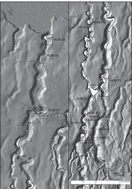
Reconnaissance survey of irrigated fi elds in Halawa Gulch showed 11 to 12 hectares of fi elds and we intensively mapped 32 complexes representing about 5 hectares (Fig. 3). Others were visited to compare their layout to a Kohala Sugar Company Map from 1935 which generally
indicated the size and location of pondfi elds. Here we describe fi ve of the 32 intensively sur- veyed complexes to give the reader a sample of the range in size, composition, and irrigation techniques found in the West and East Halawa Gulches. We begin with the uppermost fi elds (HLW-3, HLW-13), then describe lower fi elds (HLW-11, HLW-31), and end with a complex near Hapu‘u Bay (HLW-29). Nearly all these systems can be found on historic period maps, suggesting their continuous use well after European contact. Excavations and radiocarbon dating suggest these were fi rst constructed across the study area in the Expansion Period (1200–1650 A.D.) and continued to be built and remodelled, probably reaching maximum production sometime in the Proto-Historic Period (1650–1795) (see Kirch 1985 for defi nition of the Hawaiian culture historical sequence).
5.1 Upper Halawa Gulch
Upper West Halawa Gulch (HLW-3A to -3I)
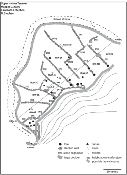
HLW-3 is a terrace complex 64 metres north-south by 50 metres east-west located on the east bank of the stream (Fig. 4). It has a total area of 0.21 ha and contains nine stacked stone, earth fi lled, terraces (HLW-3A to -3I). Bordered by the stream on the west end HLW-3A through -3E are roughly rectangular in shape and lack a wall on the streamside. A stone alignment transects the centre of the fi elds in a north-south direction. While the water intake location was not discovered, it is likely the system was fed from a short, direct irrigation ditch off the stream and had an internal ditch that followed the stone alignment along the eastern side to
Figure 3 Known irrigated fi eld complexes in Halawa Gulch
distribute water more evenly over terraces.
Upper East Halawa Gulch (HLW-13A to -13AM)
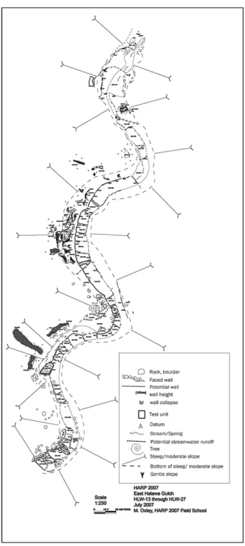
HLW-13 is a barrage terrace complex in East Halawa Gulch 1.26 ha in size built directly in the stream bed (Figs. 5 and 6). We presume that in addition to stream runoff, an un-located natural spring somewhere near the top of the system added to the irrigation water available.
The barrage complex itself consists of 37 irrigated terraces forming the main barrage (HLW- 13C to -13AM), with two additional terraces that may have been used for habitation or dry- land agriculture (HLW-13A and 13B). These are like other terraces in the area with stone retaining walls separating each terrace. They range from a single course to as many as eight
Figure 4 Irrigated Terrace Complex (HLW-3A to -3I), Upper West Halawa Gulch. This complex has 14 garden plots, is 0.212 ha in total size, and has an average plot size of 151 m2
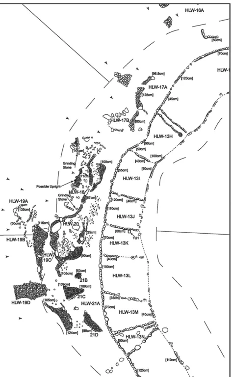
Figure 5 Barrage-Styled Pondfi elds (HLW-13), Upper East Halawa Gulch. This complex has 39 garden plots, is 1.264 ha in total size, and has an average plot size of 324 m2
Figure 6 Examples of Barrage-Styled Pondfi elds (HLW-13) and associated features, Upper East Halawa Gulch
courses high. HLW-13C is the fi rst of the irrigated barrage terraces. Moist soil here suggests the spring may begin to reach the surface at this point; however HLW-13E is the fi rst terrace in the complex with fl owing surface water. From this point water continues to fl ow continu- ously throughout the remainder of the system.
5.2 Lower Halawa Gulch
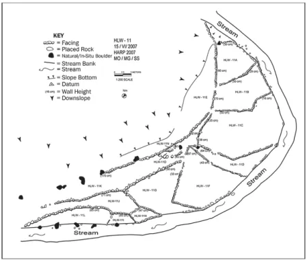
Lower West Halawa Gulch (HLW-11A to 11O)
HLW-11 is a small 0.18 ha system located on a stream bend. It is comprised of 14 terraces (HLW-11A to -11O) that stretch for nearly 100 metres within 10–50 metres of the bank (Fig.
7). Terraces range in size from less than 10 × 10 metres to 16 × 27 metres and retaining walls from one to fi ve courses high. Like HLW-3, irrigation water was likely tapped from the stream at the top of the system and bifurcated along a small interior ditch visible in our plan view map as bends in retaining walls at the upper end and short interior alignments at the lower end of the fi elds.
Lower Halawa Gulch (HLW-31A to -31H)
HLW-31A to -31E is a complex of fi ve large rectangular agricultural terraces covering an area of 0.28 ha along 161 metres of the south side of a sharp bend in the stream (Fig. 8). Terrace walls range up to six courses of stones high. HLW-31 abuts an historic oven site as well as a
Figure 7 Irrigated Terrace Complex (HLW-11A to 11O), Lower West Halawa Gulch. This complex has 13 garden plots, is 0.184 ha in total size, and has an average plot size of 142 m2
possible habitation to the south. Like other fi elds, these were likely watered by tapping the stream at the top of the fi elds but may have had an exterior ditch running parallel to the stream at the foot of the gulch slope.
Figure 8 Irrigated Terrace Complex (HLW-31A to -31H), Lower Halawa Gulch. This complex has fi ve garden plots, is 0.28 ha in total size, and has an average plot size of 560 m2
Figure 9 East Bank Irrigated Terrace Complex HLW-29A to -29J, Lower Halawa Gulch
Lower Halawa Gulch (HLW-29A to -29M)
HLW-29 is a complex roughly 0.33 ha in size with two series of terraces running south to north on the eastern and western banks of the stream (Figs. 9 and 10). On the eastern side (HLW-29B to -29J), irrigation water was diverted from a small natural pool of water at the top of the system and used to water the main set of terraces that border the stream (Fig. 9).
Irrigation water was probably also drawn to feed higher terraces on the side of the complex opposite the stream (HLW-29F and -29G). At the top of the system, a small terrace above the fi elds on the west bank appears to have been used for habitation (HLW-29A).
This portion of the complex has nine garden plots, is 0.328 ha in total size, and has an average plot size of 364 m2.
A beach access road separates the eastern terraces from a set of three west bank terraces (HLW-29K, -29L, and -29M) (Fig. 10). Excavations and geophysical survey in later seasons showed this small group of terraces has a long history of construction and has been slightly realigned over time (McCoy and Graves 2008). Irrigation water was likely drawn from the stream much lower than the east bank terraces. It was brought along the upslope side of HLW-29M and allowed to fl ow down this group and eventually out to rejoin the stream at a point that is today covered by the beach road.
6. YIELD, POPULATION, AND LABOUR ESTIMATES
To calculate production, the size of population that could have been supported, and labour requirements, we used criteria set out in Ladefogedet al. (2009) that allow us to use the area under cultivation to approximate: (1)yield (8.5 metric tons [dry wt]/ha/year); (2)d total popu-
Figure 10 West Bank Irrigated Terrace Complex HLW-29K to -29M, Lower Halawa Gulch. This map shows excavation units and conductivity/resistivity survey results used to locate buried features
lation supported (5.48d people/metric ton; based on 4 kcal per g dry wt and a diet of 2 kcal/day) which we expressed in terms of households (average 6 people per household); and (3) the number of full-time farmers required to cultivate (1.45 workers per ha/year; assuming 300 d days × 8 work-hours per day) (Table 2). Clearly these estimates mask variation in terms of yield, diet, and work, but they nonetheless allow us to consider what the local conditions could have been at the time of maximum production in the Proto-Historic Era. For example, it appears that most fi eld systems could have supported the equivalent of perhaps one to three households but only required the labour of one person devoting 1/2 to 1/3 of their potential full time labour. The largest complex described here, HLW-13, may have supported around 10 households with the labour equivalent of just two people working full time. Incredibly, 517 people could have been sustained on the cultivation of Halawa’s taro pondfi elds by as few as 17 full-time farmers.
Given these conditions, we can start to consider how small fi elds scattered across the branches of Halawa Gulch presented different opportunities and constraints for commoner farmers focused on an anti-surplus ‘domestic mode of production’ (Sahlins 1972) relative to chiefl y demand for produce. On the one hand, these fi elds required little tending for the num- ber of people who could have been fed. Thus, depending upon local population density, sur- plus may have been created with relative ease. At the same time these fi elds did not present the same large base of surplus when compared with centralised large valleys.
There is some evidence in the layout of fi elds that supports the interpretation that there was relatively less top-down control of small valley fi elds as compared to similar environ- ments. In Fig. 11, we compare average size of fi eld plots (m2) in Halawa Gulch with Kawailoa- uka, an upper section of the well-documented Anahulu Valley (O‘ahu Island). Kirch et al.
(1992: 138–139) note Kawailoa-uka represents only a small portion of the area’s total capacity and lacks examples of large complexes found elsewhere in Anahulu. This is true for other large valleys on Kaua‘i and Moloka‘i Islands where complexes over fi ve times the largest fi elds in Kawailoa-uka or Halawa Gulch have been documented (Earle 1978; Kirch 1977).
What sets small valleys like Halawa apart from Anahulu and other valleys is that small valleys lack large fi elds entirely. More interestingly, we see a major contrast in average garden plot
Table 2 Estimate of yield, population supported, and labour required for Halawa Gulch fi elds
No. of Features
Area (hectares)
Approximate Yield (8.5 metric tons [dry wt]/ha/year)
Total Population Supported (5.48 people/
metric ton [4 kcal per g dry wt; 2 kcal/day])
No. of Families (6 people per
household)
Labours Required (1.45 workers
per ha/year [300 days, 8 hr per/day])
HLW-3 9 0.21 1.80 9.87 1.65 0.31
HLW-11 15 0.18 1.56 8.57 1.43 0.27
HLW-13 39 1.26 10.74 58.88 9.81 1.83
HLW-29 13 0.33 2.79 15.28 2.55 0.48
HLW-31 21 0.28 2.38 13.04 2.17 0.41
See Ladefoged et al. (2009) for a detailed account of estimation methods.
size with uniformly small plots reported for Anahulu but a wide range in Halawa Gulch. If we accept the premise that the subdivision of fi elds via secondary ditches was ‘extremely important from the sociological viewpoint of internal tenure arrangements within irrigation systems’ (Kirchet al. 1992: 139), then smaller, more uniform, plots are indicative of closely monitored Anahulu fi elds. Further, a correlation between increasingly smaller, more uniform fi elds during the development of the rain-fed North Kohala fi eld system have also been inter- preted as an indicator of greater top-down monitoring of agricultural production through standardi zation (McCoy 2000). Halawa Gulch fi elds run counter to this pattern, however, perhaps indicating less restrictive management despite good evidence for the use of internal ditches. There are inherent dangers in using plot size and uniformity as metrics of manage- ment style since we lack detailed information on the chronology of fi eld construction, and fi eld layout patterns may be constrained by the natural land-form of small valleys. Future research should consider all possible explanations for differences in fi eld layout.
In sum, we believe the limited size of fi eld complexes in small valleys helped create conditions that were not attractive for direct, top-down management by elites when compared with the continuous farmlands found in large valleys and rain-fed fi elds. The ‘wet and dry’
hypothesis of Kirch (1994) is extended here by placing small-valley irrigated agriculture in
Figure 11 Average size of fi eld plots (defi ned by bunds) in relation to the total area of each fi eld recorded (defi ned as a single irrigation unit), in a large valley (Anahulu) and a small valley (Halawa). Plots in the smaller valley are generally larger and show greater variability in size
the category of limited agricultural potential, along with dry, rain-fed fi eld systems. We believe that future research will show that even where irrigated agriculture was present, there could be limiting factors that made expansionist warfare attractive for chiefs looking to increase their power base.
7. CONCLUSIONS
In this chapter we present new fi eld surveys from one of Hawai‘i Island’s small valleys, Halawa Gulch in the North Kohala District, and suggest that small valley irrigated agriculture represents an exceptional case in the application of the ‘wet and dry’ hypothesis. Several lines of evidence, including a lack of management through plot subdivision, suggest that during the Proto-Historic Period, small valleys were not as attractive a target for top-down managed farming when compared with large valleys or rain-fed fi eld systems. In these systems, groups of farmers of perhaps one to three households could have produced subsistence and surplus levels of taro with remarkably little effort. However, chiefs may have chosen to monitor more closely surplus elsewhere where there weren’t the same limitations on expansion. This is analogous to how inherent limitations in terms of absolute productive capability of dry, rain- fed agriculture could have provided motivation for expansionist warfare. But, in this case the limitations for small valley agriculture are on the maximum potential for surplus rather than productive capability.
ACKNOWLEDGMENTS
This research was supported by the National Science Foundation Research Experience for Undergraduates Program (Award # SES-0552977). We want to thank Julie Field for her con- tributions to documenting and understanding the agricultural landscape of Halawa Gulch.
Thanks also to our colleages on the larger NSF project ‘Long-Term Dynamics of Population Growth, Agricultural Intensifi cation, and Sociopolitical Change: Hawai‘i as a Model System (1200–200 yr B.P.)’ (Award # HSD-0624238): Oliver Chadwick, Patrick Kirch, Thegn Ladefoged, and Peter Vitousek. David Addison and Matthew Spiggs for organized an excellent and pro- ductive session at the IPPA conference in Hanoi and we thank them for inviting us to partici- pate and contribute this chapter. Surety Kohala Corporation, Kamehameha Schools, Vipassana Hawai‘i, New Moon Foundation, and George and Alexa Russell graciously granted us per- mission to conduct archaeological research on their property. Thanks also to Alex Baer, Anna Browne-Ribeiro, Fred Cachola, Vikki Creed, Robin Connors, Bennett Dorrance, James Flexner, Michael Gomes, Amy Hathaway, Jack Hoyt, Kathy Kawelu, Susan Lofton, Windy McElroy, Peter Mills, Robin Mullin, Gail Murakami, Mark Oxley, Courtney Rader, Lilie Richards, Bill Shontell, Jesse Stephen, and Nani Swenson. Matthew Spiggs, Thegn Ladefoged, and an anony- mous reviewer read a previous version of this chapter we thank them for their valuble comments.
REFERENCES
Cordy, R., E. Komori, and K. Shun
2005 Archaeological Work in Waipi‘o Valley, Hāmākua District, Hawaii Island. Hawaiian Archaeology10: 70–95.
Earle, T. K.
1978 Economic and Social Organization of a Complex Chiefdom: The Halelea District, Kaua‘i, Hawaii. Ann Arbor, Museum of Anthropology, University of Michigan.
Erkelens, C. and J. S. Athens
1994 Archaeological Inventory Survey Kohala Plantation Village, North Kohala, Hawai‘i.
Prepared for Chalon International of Hawaii, Inc. Honolulu, Hawai‘i: International Archaeological Research Institute, Inc.
Field, J. S. and M. W. Graves
2008 A New Chronology for Pololu Valley, Hawai‘i Island: Occupational History and Agricultural Development. Radiocarbon50: 205–22.
Juvic, S. P. and J. O. Juvik
1998 Atlas of Hawai‘i.Third edition. Honolulu: University of Hawai‘i Press.
Kirch, P. V.
1977 Valley Agricultural Systems in Prehistoric Hawaii: An Archaeological Consideration. Asian Perspectives20: 246–280.
1985 Feathered Gods and Fishhooks: An Introduction to Hawaiian Archaeology and Prehistory.
Honolulu: University of Hawai‘i Press.
1994 The Wet and the Dry: Irrigation and Intensifi cation in Polynesia.Chicago: University of Chicago Press.
Kirch, P. V., M. Sahlins, M. Weisler, and M. Spriggs
1992 Anahulu: The Anthropology of History in the Kingdom of Hawaii. Vol II. Chicago: University of Chicago Press.
Ladefoged, T. N. and M. W. Graves.
2000 Evolutionary Theory and the Historical Development of Dry-Land Agriculture in North Kohala, Hawai‘i. American Antiquity65(3): 423–448.
2008 Variable Development of Dryland Agriculture in Hawai‘i: A Fine-Grained Chronology from the Kohala Field System, Hawai‘i Island. Current Anthropology49(5): 771–802.
Ladefoged, T. N., M. W. Graves, and J. H. Coil
2005 The Introduction of Sweet Potato in Polynesia: Early Remains in Hawai‘i. Journal of the Polynesian Society114: 359–373.
Ladefoged, T. N., M. W. Graves, and R. P. Jennings
1996 Dryland Agricultural Expansion and Intensifi cation in Kohala, Hawai‘i Island.Antiquity 70: 861–80.
Ladefoged, T. N., M. W. Graves, and M. D. McCoy
2003 Archaeological Evidence for Agricultural Development in Kohala, Island of Hawai‘i.
Journal of Archaeological Science30: 923–940.
Ladefoged, T. N., M. W. Graves, B. V. O’Conner, and R. Chapin
1998 Integration of Global Positioning Systems into Archaeological Field Research: A Case
Study from North Kohala, Hawai‘i Island. SAA Bulletin16: 23–27.
Ladefoged, T. N., P. V. Kirch, S. O. Gon III, O. A. Chadwick, A. S. Hartshorn, and P. M. Vitousek 2009 Opportunities and Constraints for Intensive Agriculture in the Hawaiian Archipelago Prior
to European Contact. Journal of Archaeological Science36: 2374–2383.
McCoy, M. D.
2000 Agricultural Intensifi cation and Land Tenure in Prehistoric Hawai‘i (Master’s thesis) Auckland, New Zealand: University of Auckland.
McCoy, M. D. and M. W. Graves
2007 An Archaeological Survey of Halawa and Makapala Ahupua‘a, North Kohala District, Hawai‘i Island: Hawai‘i Archaeological Research Project 2007. Report on fi le with the Hawaii State Historic Preservation Division, Kapolei.
2008 An Archaeological Investigation of Halawa and Waiapuka Ahupua‘a, North Kohala District, Hawai‘i Island. Report on fi le with the Hawaii State Historic Preservation Division, Kapolei.
2010 The Role of Agricultural Innovation on Pacifi c Islands: A Case Study from Hawai‘i Island.
World Archaeology42: 90–107.
McCoy, M. D., M. W. Graves, and G. P. Asner
2010 Reconstructing Irrigated Agriculture in the Hawaiian Islands through Slope Contrast Mapping with Airborne Lidar Data. Paper presented at the 75thAnnual Society for American Archaeology meetings, St. Louis, MO.
Newman, T. S.
1970 Hawaiian Fishing and Farming on the Island of Hawaii in AD 1788.Honolulu, Department of Land and Natural Resources.
Palmer, M. A., M. Graves, T. N. Ladefoged, O. A. Chadwick, T. K. Duarte, S. Porder, and P. M. Vitousek 2009 Source of Nutrients to Windward Agricultural Systems in Pre-Contact Hawai‘i.Ecological
Applications19: 1444–1453.
Sahlins, M.
1972 Stone Age Economics. Aldine Transaction.
Schweitzer, S. V. and M. Gomes
2003 Kohala ‘Aina: A History of North Kohala.Honolulu: Mutual Publishing.
Stokes, J. F. G. (edited by T. S. Dye)
1991 Heiau of the Island of Hawai‘i: A Historic Survey of Native Hawaiian Temple Sites.
Honolulu: Bernice P. Bishop Museum Press.
Tuggle, H. D. and P. B. Griffi n (eds.)
1973 Lapakahi, Hawaii Archaeological Studies. Asian and Pacifi c Archaeology Series No. 5.
Honolulu: Social Science Research Institute, University of Hawaii.
Tuggle, D. and M. J. Tomonari-Tuggle
1980 Prehistoric Agriculture in Kohala, Hawaii. Journal of Field Archaeology7: 297–312.
Tomonari-Tuggle, M. J.
1988 North Kohala: Perception of a Changing Community; A Cultural Resources Study. Division of State Parks, Outdoor Recreation and Historic Sites, Department of Land and Natural Resources, State of Hawaii.
Vitousek, P. M., O. A. Chadwick, P. Matson, S. Allison, L. Derry, L. Kettley, A. Luers, E. Mecking, V.
Monastra, and S. Porder
2003 Erosion and the Rejuvenation of Weathering-Derived Nutrient Supply in an Old Tropical Landscape. Ecosystems6: 762–772.
Vitousek, P. M., T. N. Ladefoged, P. V. Kirch, A. S. Hartshorn, M. W. Graves, S. C. Hotchkiss, S.
Tuljapurkar, and O. A. Chadwick
2004 Soils, Agriculture, and Society in Precontact Hawai‘i. Science304: 1665–1669.
Wolforth, T. R.
2003 An Archaeological Inventory Survey for the Proposed New Moon Retreat Center in ‘Iole, North Kohala, Hawai‘i (portions of TMK: 5-3-5:5 and 10): Investigations into the Changing Patterns of Water Control in the Uplands of ‘Iole.Scientifi c Consultant Series Inc.