Status and Problems in Location Model Research for Guidance Signage in Comprehensive
Passenger Transportation Hubs
著者 Jianxin Lin, Jifeng Dai, Rui Song journal or
publication title
International Review for Spatial Planning and Sustainable Development
volume 4
number 3
page range 27‑35
year 2016‑07‑15
URL http://hdl.handle.net/2297/45837
doi: 10.14246/irspsd.4.3_27
27
DOI: http://dx.doi.org/10.14246/irspsd.4.3_27
Copyright@SPSD Press from 2010, SPSD Press, Kanazawa
Status and Problems in Location Model Research for Guidance Signage in Comprehensive Passenger
Transportation Hubs
Jianxin Lin
1, 2*, Jifeng Dai
2and Rui Song
11 School of Traffic and Transportation, Beijing Jiaotong University
2 Beijing Urban Transportation Infrastructure Engineering Technology Research Center, Beijing University of Civil Engineering and Architecture
* Corresponding Author, Email: [email protected] Received: 11 December, 2015; Accepted: 17 March, 2016
Key words: Comprehensive Passenger Transportation Hub, Guidance Sign, Location Model, Massive Passenger Flow, Spatial Topological Network
Abstract: Internal guidance signs are critical for the normal operation of a comprehensive passenger transportation hub. In the present paper, the procedures, methods and restrictions on the development of guidance sign locations are summarized in terms of the planning and design method of guidance signs and an evaluation of guidance sign service manuals after a sorting and analysis of relevant literature.
The results show that the existing location model fails to quantitatively describe the behavior characteristics of massive passenger flows and results in the spatial planning and design of guidance signage being inaccessible for many in mass passenger transit and spatial topological networks resulting from 3D hub architecture make the constraint conditions of location models more complex.
Sophisticated guidance signs and location models responding to behavioral characteristics and spatial topological networks will be a trend of interest in the optimal layout of future comprehensive passenger transportation hubs.
1. INTRODUCTION
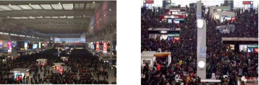
Travelers and management sectors have an increasing concern for transport hub guidance signs as information mediums for comprehensive Passenger Transportation Hubs (PT Hubs) where multiple forms of public transport merge (hereinafter referred to as a hub). The advantages and disadvantages of guidance sign location directly affect the internal traffic organization and distribution of urban PTBs. Illegible guidance sign systems may induce serious safety accidents, in particular, under massive or congested passenger flows. On February 1, 2016, China’s Spring Festival travel rush combined with poor weather to cause a massive passenger flow - the time of entry to and exit from the Hongqiao Hub was delayed by several hours (Fig.
1), such as has occurred frequently in Wuhan and Guangzhou. The absence of
an effective hub guidance sign added to the paralysation of the hub under the
pressure of a massive passenger flow, in addition to the weather and train
delays. Under the specially-dense passenger flow, the passengers inside the
28 IRSPSD International, Vol.4 No.3 (2016), 27-35
hub react with urgency to reach their destination accurately and reliably using the shortest travel time or pathway according to the guidance sign system. In addition, the hub management authority also expects to provide reasonable transportation facilities, setting up optimal guidance sign locations so as to provide quality traffic services for travelers. Therefore, the planning and design of guidance signs in comprehensive PT Hubs has become a broad research hotspot in research fields related to facility location; it is a key issue for assisting the construction and operation of hubs, improving their efficiency and travel service quality.
Figure.1. Stagnated passenger flow and queue for Hongqiao railway station
The remainder of this paper is organized as follows. The basic problem concept is described in the next section, Section 2. In Sections 3 and 4, the planning method and evaluation method are described, respectively. Section 5 presents policy suggestions and future research trends of guidance signage.
Finally, two critical problems are concluded in Section 6.
2. BASIC PROBLEM CONCEPT
The guidance sign system refers to a comprehensive solution to comprehensively communicate PT Hub functions, such as information transfer, visualization, identification and orientation, so as to help visitors to obtain their required information using minimal time, based on the guidance of systematic design in the spatial and information environment. Such a guidance system consists of two parts, an orientation system and a signage system. In this paper, a comprehensive guidance sign in a comprehensive PT Hub is a system pertinent to the 3D space, which consists of multiple story, a centralized passenger flow, and requiring integration across hub facilities.
Therefore, understanding the service level of PT Hub guidance signs is a key research issue, particularly when taking into consideration multilayer 3D architecture, massive passenger flows and guidance signage.
Entrance
Lift Stairs Elevator
Security inspection
Ticketing Entertainment&
shopping Entertainment&
shopping
Passage Passage
Platform Lift
Stairs Elevator
Ramp Gate
Service facility 3D spatial
facility
Ticketing facility
Plan spatial facility Info induced
facility Hall
Guidance sign
Figure 2: Schematic flow for passenger entrance
Platform
Lift Stairs Elevator
Entertainment&
shopping Passage
Ramp
Lift Stairs Elevator
Ramp Gate
Hall
Guidance sign
Exit
Service facility 3D spatial
facility
Ticketing facility
Plan spatial facility Info induced
facility
Figure 3: Schematic flow for passenger exit
Typical passenger flows inside a hub are shown in Figures 2 and 3 above.
A guidance sign is effective through the entire process of a passenger’s traffic behavior. The schematics mainly highlight the flows of passengers either entering or exiting a station.
3. RESEARCH ON PLANNING METHOD FOR PT HUB GUIDANCE SIGNAGE
Lynch (1960), an architect, proposed the planning of guidance signage as early as 1960. Its purpose is to allow visitors to obtain their required information in as fast a time as possible within the modern complex spatial and information environment. Patkar and N. (1984) presented the idea that a hub’s service level cannot be separated from the presence of reasonable guidance and directional signage, and that the location of such signs can directly improve the accessibility of a destination and reliability of arrival time for passengers and further improve a passenger’s satisfaction in a hub.
Beginning from the 1960s and ‘70s, traffic orientation system design started to be researched and the application of graphic symbols gradually evolved into creating flows and methodology for guidance sign planning.
Lynch (1960) originally extracted urban essential elements, applying them to signage and creating the theory of guidance sign planning for application in urban planning and design. Later intensive research shifted to the importance of passenger transit signage in transport hubs and studies of signage standardization were begun. With intensive research on the streamlining of hub design, Arthur and Passini (1992) made guidance signage one of their design objectives, comprehensively taking into account the integration of people, architecture and guidance signage, determining the key design elements of guidance signage using the wayfinding method. Their results were widely accepted, modified and applied by most scholars. For example, Passini (1996) has extensively elaborated on the logical mechanism and specific application of the wayfinding method in spatial structure and interactions.
This method has mostly been used for the evaluation of hub systems. In the
last 10 years, Ichiro (2005) analyzed the example of Japan's Yokohama
Railway Station and summarized the pedestrian traffic flow and procedures in
the hub, researching the standard design and barrier-free design of guidance
signage in the full process. Resultantly, the planning and design of the hub’s
guidance signage became richer and more refined. Mehranian et al. (2001)
planned and designed air flight information signage in order to shorten
passengers’ wayfinding time. Chen, J. (2004) started research on public traffic
guidance systems, and Xiao (2006), Mou (2006), Zhang and Yan (2007) and
30 IRSPSD International, Vol.4 No.3 (2016), 27-35
others studied the spatial visual environment, hub transit guidance sign standards and spatial orientation issues. The planning and design of guidance signs became more standardized in China with the introduction of GB_T 15566.1-2007: Guidance system for public information – Setting Principles and Requirements and TB10074-2007 J81-2008: Code for Design of Passenger Transport Information System of Railway Passenger Stations.
Concurrently, research results became more abundant. For example, Bao, Dong, and Su (2009) performed a special survey on the hub guidance signage, Wu, Hu, and Chen (2011) studied visual perception based on the motion of space, and Guo, Yu, and Dong (2015) studied the planning and design issues of hub guidance signage based on human-computer interactions. In location method research, Tam (2011) proposed the multi-objective planning model based on the maximization of space incorporating level and orientation distances for the layout of a single-story hub’s architectural guidance signage (Lin, Kang, & Shi, 2013). The above research results were mostly applied in the planning and design practice of transportation hubs, such as in Beijing, Shanghai, Guangzhou, Xi’an, and so on. However, the studies of existing guidance sign layout are limited within their qualitative analyses on the flows and lines of passengers inside the hub. The signage is laid out in key locations according to the standards, but a perfect optimal quantitative layout method has not yet been created. Guidance sign layout is to be further resolved and modelled based on multi-story spatial networks with visual characteristics of massive passenger flow.
4. RESEARCH ON THE EVALUATION METHOD OF SERVICE LEVEL IN HUB GUIDANCE SIGN SYSTEMS
Increasingly, scholars have intensively become concerned with and studied guidance signage, qualitatively analyzing planning and design decision-making defects based on experiences since 2007. Previous studies were mostly based on the evaluation indexes of guidance signage, based on the elements of guidance signs and the “static” evaluation of guidance sign location. Accordingly, in improving relevant evaluation index systems, scholars have refocused their research toward evaluation models based on passenger behavior, mainly in the two following categories:
The first category is based on the spatial environment and the process comparison method in which the reasonability of guidance sign locations is qualitatively evaluated based on traffic engineer experiences in the hub. The design elements (location, color, light, font, etc.) in the hub’s guidance signs were compared (Jeon & Hong, 2009). Additionally, some researchers have evaluated guidance signs based on the analytic hierarchy process and satisfaction analysis method (Choi, J.-S. & Yoo, B.-B., 2006; Choi, J.-S. &
Yoo, H.-B., 2006). This method depends heavily on designers’ experiences as there is a lack of commonality between the layout of guidance signage across different hubs; it is difficult to isolate massive passenger flows and the visual effect mechanism of signage within the essential context of multi-story topological transport hub network architecture. Therefore, the method is insufficiently convincing and is to be refined scientifically.
The second category involves the analytic evaluation method in which the
hub’s passenger traffic behavior and the interactions between people and
signage are resolved, and further, the service level of the guidance signs’
design elements are evaluated. Studies on the evaluation of service level focus more on the indexes, such as coverage of the guidance sign, time of passenger arrival to the destination, optimal environment for visual accessibility, etc.
With the aim of setting up guidance signs as a method for resolving passenger traffic behavior, the reasonability of design elements, such as height, font and layout background, are further evaluated. For instance, Tam and Lam (2004) constructed a simplified traffic network model, introduced a passenger traffic behavior feature, and revealed the feasibility of a passenger’s visual behavior in regard to the service level of guidance signs. Nevertheless, they did not study the passenger’s visibility considering the spatial dimensions of a multi- story linked network. Chen, Z., Chen, and Xiong (2009) analyzed the effect of a passenger’s visual zone using the visual field superposition technique and further evaluated the reasonability of guidance signs; Wu, Hu, and Chen (2011) created the streamline visibility index based on visual perception, and provide the quantitative evaluation and analysis method for the reasonability of guidance signs inside railway stations. It has been shown that research on guidance signage using the analytic method assessing passenger’s visual behavior is feasible and has gradually becomes a hotspot of research.
However, these methods are unclear about the flow rules of massive passenger flow inside hubs, and merely focus on single-story topological networks without any consideration of the associated multi-story spatial architectural distribution of a hub. Therefore, the accuracy of such evaluations is in doubt.
5. POLICIES FOR ISSUES AND TRENDS IN GUIDANCE SIGN RESEARCH
5.1 Existing issues in hub guidance sign research
Four existing issues may be identified by analyzing the status of research on the optimization method, as applied to hub guidance sign layout:
(1) In academic thought, most existing research is based on the issued national or industrial standards and specifications. The guidance signs are laid out at critical points in traffic lines based on single-story architectural features, signage design elements and engineer’s experiences in a hub, in addition the reasonability of their distribution is qualitatively analyzed. Rare studies focused on the traffic behavior and movement rules of massive passenger flows for identifying an optimal model for multi-story spatial guidance sign layout.
(2) In research methodology, guidance sign layout based on massive passenger flows needs abstracted multi-story and visual virtual topological network models, although the optimal model of guidance sign layout depends on a common location problem. Such problem requires the resolution of basic considerations, such as of traffic geographic information technology and graph theory, however existing basic research on the key issues of spatial topological networks for multi-story hub guidance sign layout is insufficient.
(3) In the resolution of scientific issues, existing research mostly focuses
on the direct transformation of guidance sign layout problems according to the
p-center problem and p-median problem. However, difficulties in
quantitatively describing the need of guidance signs lead to the difficulties in
constructing the target functions of the above two models. Therefore, the
existing research on optimal models of guidance sign layout is absent of
32 IRSPSD International, Vol.4 No.3 (2016), 27-35
scientific quantitative descriptions and the resolution of passengers’ needs for guidance signs.
(4) Regarding the choice of evaluation indexes for optimal guidance sign layout, existing research focuses on the evaluation index of single-story architectural guidance sign coverage, therefore leading to difficulties in quantifying needs because of the absence of traffic behavior analysis of passengers in multi-story hubs and basic research on the mechanisms of guidance signs within these environments. As a result, it is difficult to select an optimal index for guidance sign layout associated with multi-story architecture; and models of multi-story guidance sign layout are lacking in systematic research results.
5.2 Trend and policies for research of hub guidance sign location research
According to the above research status and summarization of problems, it is believed that the trend of guidance sign research in existing hubs mainly includes models of guidance sign layout under optimal efficiency, models of guidance sign layout based on the traffic behavior of massive passenger flows and models of guidance sign layout in 3D spatial networks.
(1) Layout of guidance signs combined with research on guidance sign efficiency
The efficiency concept and measurement method must be updated for assessing guidance sign placement in comprehensive Passenger Transportation Hubs in order to derive optimal results for guidance sign location: 1) the target value of guidance signs (P
E) is defined as a subjective value, which is relatively fixed and possesses less influence on the efficient improvement of guidance signs in a hub; 2) the apparent value of guidance signs (Pi) and the deviation function value of the passenger behavior (f (∆𝑋
𝑖,
∆𝑌
𝑖)) are determined. The resulting value has a direct influence on the efficient improvement of a comprehensive Passenger Transportation Hub, that is, the more stable the passenger behavior is, or the bigger the positive effect of factors is, the higher the system’s apparent value will be. According to the factors influencing the efficiency of a guidance sign, in this paper, it is believed that the following polices can significantly improve the efficiency of a guidance sign in a comprehensive Passenger Transportation Hub:
① A guidance sign is seeable. A hub’s buildings are designed in an
overall manner by considering the location of a guidance sign. The inner space
of a comprehensive Passenger Transportation Hub is closely related to the
architectural design of the buildings. The hub’s buildings must be designed
integrally in space, color, light, temperature and humidity, etc., with
consideration being directed particularly toward the requirement of efficient
lighting, so that passengers may find signs easily; meanwhile, regarding the
color of guidance signs, distinguished colors must be set alongside indications
of direction and distance (see Figure 4) so that the passenger can select the
most efficient pathway according to their destination’s transport route.
Figure 4: Easily found guidance sign Figure 5: Continuously-designed guidance signs
② Continuously-designed guidance sign: the signage must be set up according to the overall layout of facilities. So, the distance between guidance signs inside the hub must be determined according to the range of visibility, typically every 40-50m. When the distance is more than 20m, the posted signage can be supplemented; additionally, the continuance of guidance signs ensures that they are apparent from ground to head level (See Figure 5) in order to facilitate a passenger’s ability to find their target pathway continuously and conveniently.
③ The guidance sign is adequate in size and height. The size and height of the guidance sign must be determined according to the behavior characteristics of passenger flow owing to differing passenger density and retention extent in different facilities inside a comprehensive Passenger Transportation Hub. According to the experience in a Japanese Passenger Transportation Hub, a hanging guidance sign is typically 2.2~2.5m from the floor.
④ The set guidance signs are matched to the surrounding properties. The passenger’s interpretation in selecting and finding a pathway is subject to error due to the saturation of surrounding commercial and entertainment zones.
Therefore, a guidance sign must be set against the surrounding properties in a manner which precludes the misguiding of a passenger selecting their pathway. Once such a problem occurs, the posted signage must be supplemented with different properties to guide a passenger to pass through the hub efficiently from that point forward.
(2) Model of guidance sign layout based on the traffic behavior of massive passenger flow
The movement rule and visual behavior of massive passenger flow and effect of guidance signs are the decisive factors for the layout of guidance signs in the hub. On the basis of mastering the movement rule and attributes of passengers inside the hub, data such as basic attributes of passengers (sex, age, destination, familiarity with hub, etc.) can be collected and surveyed, and the importance of destination facilities on different architectural floors during transit can be graded using a questionnaire to determine the weighting and missed properties of signage. Moreover, it will be an effective, feasible method for the quantitative analysis of traffic behavior of massive passenger flows and guidance sign location, to collect geometrical data (such as travel time and traffic facilities), to systematically resolve the mechanisms of movement and visual behaviors of massive passenger flows, and to abstract the traffic behavior of massive passenger flows as a visual matrix.
(3) Model of guidance sign layout in a 3D spatial network
34 IRSPSD International, Vol.4 No.3 (2016), 27-35
The 3D spatial network is a typical characteristic of a comprehensive Passenger Transportation Hub. Therefore, it is significant to investigate the model of guidance sign layout by applying it to a 3D spatial network.
Stairs or passage
Figure 6: Conceptual drawing of 3D multi-story spatial topological network
The model research emphasis lies in resolving the difficulty of mass transit quality, regarding: 1) how to transit to and construct a multi-story spatial topological network from single-story networks (as shown in Figure 6), which will directly lead to issues in the basic science of guidance sign layout; 2) what is the story-link in a multi-story spatial topological network, and how are the measurement indexes introduced for passenger traffic behavior, also, how is the correlation of the different story indexes described? How to combine single-story networks and passenger flows, as multi-story networks and flows, is a key issue; the solution to this problem will be directly used to describe constraints within models of guidance sign location.
6. CONCLUSION
The comprehensive Passenger Transportation Hub is an important place
for urban traffic and passenger transport. The high distribution level of its
inner passenger flow has a direct influence on its operation. Research on the
status and trend of guidance sign location models can provide an idea and
method for quantitatively evaluating the advantages and disadvantages of hub
guidance signs, in order to design stable, efficient and practical guidance signs
in the integral Passenger Transportation Hub. The research results show that
it is critical to resolve both the issues of multi-story behavior index correlation
for passenger flow as well as constructing 3D spatial topological traffic
networks. Both of the above issues have a direct influence on the applicability
and reliability of a guidance sign location model. In addition, research on the
status and policies of guidance sign location models is a necessary phase in
exploring the layout of dynamic guidance signs.
ACKNOWLEDGEMENTS
This work has been carried out under the support of Beijing Talent Cultivation Foundation ( ) and Beijing University of Civil Engineering and Architecture Research Foundation (Z10060).
REFERENCES
Arthur, P., & Passini, R. (1992). Wayfinding: People, Signs and Architecture. New York, NY:
McGraw-Hill, Incorporated.
Bao, N., Dong, Y., & Su, T. (2009). "Survey and Analysis on Guidance Sign in Beijing Subway Station". Urban Rapid Rail Transit, 22(6), 23-28.
Chen, J. (2004). "The Research on Way_Finding System Design of Urban Public Transit".
(Master), DONG HUA University. Retrieved from
http://d.wanfangdata.com.cn/Thesis/Y580706
Chen, Z., Chen, X., & Xiong, W. (2009). "Design Evaluation of Pedestrian Guidance Sign Based on the Superposition Analysis of Visual Field". Urban Rail Transportation Research, 12(4), 19-24.
Choi, J.-S., & Yoo, B.-B. (2006). "The Distribution of Signs and Pedestrians' Walking Behaviors in Underground Space - a Case Study of the Underground Shopping Centre in Tenjin, Fukuoka". Journal of the Korea Academia-Industrial cooperation Society, 7(2), 246-250.
Choi, J.-S., & Yoo, H.-B. (2006). "Characteristics of Sign Distribution in Underground Space".
Journal of the Korea Institute of Information and Communication Engineering, 10(7), 1180- 1187.
Guo, F., Yu, D., & Dong, B. (2015). "Evaluation of Guidance Sign Layout in Traffic Hub Based on Interaction between Human and Environment". Journal of Southwest Jiao Tong University, 50(4), 597-603. doi: 10.3969/j.issn.0258-2724.2015.04.004
Ichiro, W. (2005). "Standardized Guide Signs at Yokohama Station". Japanese Railway Engineering, 45, 16-18.
Jeon, G. Y., & Hong, W. H. (2009). "An Experimental Study on How Phosphorescent Guidance Equipment Influences on Evacuation in Impaired Visibility". Journal of Loss Prevention in the Process Industries, 22(6), 934-942.
Lin, Y., Kang, L., & Shi, Y. (2013). "Multi-Objective Optimized Modelling and Solution of Ifd-Nsga- Ii Algorithm for Pedestrian’s Guidance Sign Layout". Journal of System management,, 22(4), 553-559.
Lynch, K. (1960). The Image of the City. Cambridge: The MIT Press.
Mehranian, H., Fisher, D. L., Duffy, S. A., & Niswander, E. (2001). "Alternative Terminal Sign Format Evaluation: Generating Efficient Information Dense Displays". Human Factors &
Ergonomics Society Annual Meeting Proceedings, 45(23), 1676-1679.
Mou, Y. (2006). "Standard Mode of Urban Orientation System in China". Standardization of China(12), 29-32.
Passini, R. (1996). "Wayfinding Design: Logic, Application and Some Thoughts on Universality". Design Studies, 17(3), 319-331.
Patkar, S. K. M., & N., V. (1984). "Transport Terminal Design and Passenger Orientation".
Transportation Planning & Technology, 9(2), 115-123.
Tam, M.-L. (2011). "An Optimization Model for Wayfinding Problems in Terminal Building".
Journal of Air Transport Management, 17(2), 74-79. doi:
http://dx.doi.org/10.1016/j.jairtraman.2010.06.001
Tam, M.-L., & Lam, W. H. K. (2004). "Determination of Service Levels for Passenger Orientation in Hong Kong International Airport". Journal of Air Transport Management, 10(3), 181-189. doi: http://dx.doi.org/10.1016/j.jairtraman.2003.10.011
Wu, J., Hu, S., & Chen, Z. (2011). "Evaluation of Guidance Sign Layout Based on the Visual Perception of Movement Space". Journal of Tongji University (Natural science edition), 39(8), 1167-1172,1176. doi: 10.3969/j.issn.0253-374x.2011.08.012
Xiao, Y. (2006). "Visual Environment of Transit Link Space in Rail Transportation Hub".
(Master), Beijing University of Technology. Retrieved from http://d.wanfangdata.com.cn/Thesis/Y890920
Zhang , H., & Yan, K. (2007). "Transit-Induced Signage in Comprehensive Passenger Transport Hub in Shanghai South Railway Station". Traffic and Transportation: Academic Edition(B12), 7-10.